
La Bruguière
|
La Bruguière La Bruguièira |
||
|---|---|---|
.svg)
|
|
|
| region | Occitania | |
| Department | Gard | |
| Arrondissement | Nîmes | |
| Canton | Uzes | |
| Community association | Pays d'Uzès | |
| Coordinates | 44 ° 7 ' N , 4 ° 25' E | |
| height | 228-320 m | |
| surface | 16.43 km 2 | |
| Residents | 328 (January 1, 2017) | |
| Population density | 20 inhabitants / km 2 | |
| Post Code | 30580 | |
| INSEE code | 30056 | |

La Bruguière ( Occitan : La Bruguièira ) is a French commune with 328 inhabitants (as of January 1, 2017) in the Gard department in the Occitanie region . It belongs to the Arrondissement of Nîmes and the Canton of Uzès (until 2015: Canton Lussan ). The eponymous district developed on the river Hers .
geography
La Bruguière is located about 31 kilometers north-northeast of Nîmes and about 26 kilometers east-southeast of Alès . The neighboring municipalities of La Bruguière are Lussan in the north, Fontarèches in the east, Saint-Quentin-la-Poterie in the south and south-east, Montaren-et-Saint-Médiers in the south and south-west, Belvézet in the west and Vallérargues in the north-west.
history
A first settlement took place by the Volques Arécomiques , a Celtic people . The Romans later moved here and named the place Brugetia . This name refers to the heather ( brugues ) that are common in the area . The knowledge of the former inhabitants comes from excavations of the 20th century: two Merovingian - sarcophagi and 47 graves from the 12th century with remnants of memories, ceramics and Roman amphorae were found during road construction work.
The village was first mentioned in documents in 1080: the first inhabitants had built the Church of St. Martin , which was subordinate to the Monastery of Moissac. After several hundred years of use, the church fell into disrepair.
The inhabitants who remained over the following centuries devoted themselves to the cultivation of silkworms and planted mulberry trees from the Middle Ages . To obtain the silk, they used the power of water mills , remains of which are still preserved.
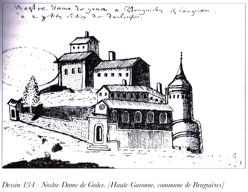
During the Hundred Years War , the residents and the monks built a protective wall up to ten meters high. This was removed at the end of the 16th century after the Duke of Ventadour occupied the city. In addition, the local history is linked to a pilgrimage to Notre Dame de Grâce, which is derived from the discovery of a statue of the Virgin Mary in a field in Bruguière. Experts put the age of the statue in the 14th century. The small church of the Assumption of Mary was built for the pilgrims in 1602 .
From 1511 to 1538 the church of St. Martin was rebuilt on the ruins of the earlier church building . In addition to the patron saint of St. Martin, it was dedicated to Saint Eutrope , the first bishop of Saintes. The building was on May 20, 1550. Benoit de la Roue (Benedictus from Rota), bishop of Chartres , consecrated . German Protestants burned the church down as early as 1562 .
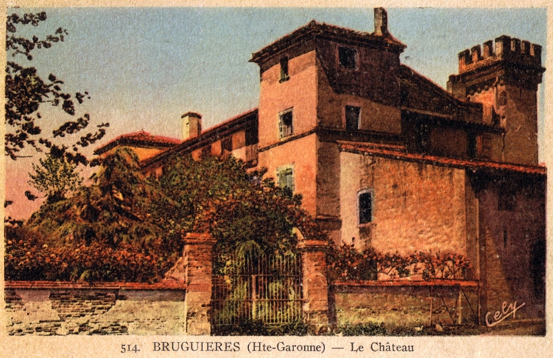
In 1560, the owner of St. Jory , Michel Dufaur, acquired the jurisdiction of Bruguière. There must have already been a castle (Château Bruguière) at that time, because an inscription above the main door of the preserved building announces that the parliamentarian Georges d'Olive had the castle rebuilt in 1657. Between 1621 and 1631 the plague raged in the country and numerous residents of Bruguière fell victim to it. In a map series from 1695 ( Cartulaire of the Abbey of St-Sernin ) Bruguières is entered with some houses. In 1740 the residents straightened the course of the river, which hardly caused any flooding. With a decree of 1789, the influence of the consuls on local development was abolished and communities were founded. Combret became the first mayor of Bruguière.
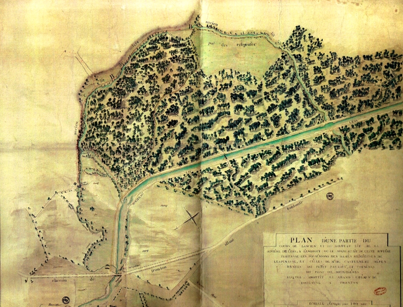
After the French Revolution , the property of the landowners was confiscated and the monastery lost its importance. The sanctuary was sold together with the monastery for 100,000 pounds in 1793 to the merchant Toulouse Lacan, who made it his residence. Eventually all the mulberry trees were cut down and a period of agriculture and fishing began, the residents became farmers, ranchers and fishermen. Thanks to frequent flooding by the Hers in the southern area of the village, there were very fertile mud deposits there.
With the start of the railway construction, Bruguière and Fronton were to be connected to the main line Bordeaux – Cette ( Sète ). Because of the rugged landscape around Bouloc and Saint-Sauveur , this plan was not implemented.
In the late 19th century, the silkworm culture was revived and brought about the prosperity of the villagers. In addition, a school was built around 1810, which also served the children of neighboring parts of the community. A house for the sick was also added. In 1904, an earlier wooden bridge over the river was replaced by a steel structure. In 1907 a new school building opened on Avenue de Toulouse. Both - the school and the hospital - served as a retirement home in the late 20th century, which was looked after by the nuns (sisters) of St. Vincent de Paul until 2007 . In 1923 the place was connected to the electricity supply. In 1952 a new town hall was completed.
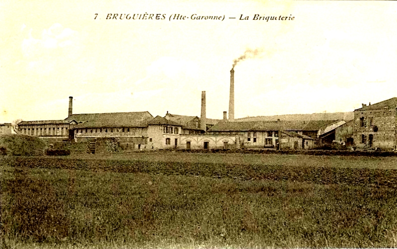
In the 20th / 21st In the 19th century, the residents made a living from tourism, their own agriculture and the 19th century industry, especially two brick factories (1862, 1875) and a briquette factory.
Population development
| year | 1962 | 1968 | 1975 | 1982 | 1990 | 1999 | 2006 | 2017 |
|---|---|---|---|---|---|---|---|---|
| Residents | 169 | 172 | 158 | 188 | 184 | 182 | 268 | 328 |
| Sources: Cassini and INSEE | ||||||||
Attractions


- Church of the Assumption
- Romanesque tower from the 12th century
- Castle
Web links
Individual evidence
- ↑ a b c d e f g h i j k History of La Bruguière on www.mairie-bruguieres.fr (French)
- ↑ Drawing by Vincent Laudin, 1665: Notre Dame de Grâce in the Bruguières commune .
- ^ View of the Virgin Mary statue, 1975
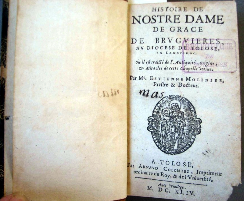
- ↑ A book from the 17th century tells the story of the pilgrimage in detail: Histoire de Nostre Dame des Bruguieres , MDCXLIV .
- ↑ View of the castle on a postcard from 1930.
- ^ Maps from 1675
- ^ Plan for the rectification of Hers, 1740 .
- ↑ Map section: go to Bruguière , there a marker points to a ZA de la Briquetterie .
- ^ View of the briquette factory, 1900