
Cornillon
| Cornillon | ||
|---|---|---|
.svg)
|
|
|
| region | Occitania | |
| Department | Gard | |
| Arrondissement | Nîmes | |
| Canton | Pont-Saint-Esprit | |
| Community association | Gard Rhodania | |
| Coordinates | 44 ° 14 ′ N , 4 ° 29 ′ E | |
| height | 58-360 m | |
| surface | 15.58 km 2 | |
| Residents | 934 (January 1, 2017) | |
| Population density | 60 inhabitants / km 2 | |
| Post Code | 30630 | |
| INSEE code | 30096 | |
| Website | http://www.cornillon.fr | |
 Village view |
||

Cornillon is a French commune in the Gard department in the region of Occitania . It is assigned to the canton of Pont-Saint-Esprit and the Arrondissement of Nîmes .
geography
The medieval southern French village with 934 inhabitants (at January 1, 2017) is located on a 80 meter high rock projection 44 kilometers northeast of Nîmes and managed by the department road served D980.
In addition to the village center ( Cornillon Village ), the municipality includes the hamlets of Cabrol , La Vérune , Saint Nabor , Saint Gely , Roman , Talazargues , Cazerneau , Privat and Ivagnas .
The Place du Barry at the top of the castle ruins offers an impressive view of the Cèze valley .
history
The history of Cornillon is strongly linked to its castle, which dates back to the 13th century. The place has long since lost its strategic importance, but thanks to the development of tourism and gastronomy, the number of inhabitants has grown steadily in recent years.
Population development
| year | 1962 | 1968 | 1975 | 1982 | 1990 | 1999 | 2009 | 2017 |
|---|---|---|---|---|---|---|---|---|
| Residents | 422 | 432 | 448 | 538 | 609 | 689 | 892 | 934 |
Attractions
- The castle has belonged to the De Sibert family for over a century . It is now used as a theater, but is still open to the public.
- Gargoyles on the rue de la gargouille
- Remains of sarcophagi next to the old parish church , which were then set on fire by the Huguenots

Castle ruins 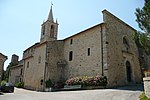
Saint-Pierre church 
Old house on the castle wall


