Aujargues
| Aujargues | ||
|---|---|---|

|
|
|
| region | Occitania | |
| Department | Gard | |
| Arrondissement | Nîmes | |
| Canton | Calvisson | |
| Community association | Pays de Sommieres | |
| Coordinates | 43 ° 47 ' N , 4 ° 7' E | |
| height | 50-143 m | |
| surface | 6.85 km 2 | |
| Residents | 846 (January 1, 2017) | |
| Population density | 124 inhabitants / km 2 | |
| Post Code | 30250 | |
| INSEE code | 30023 | |
| Website | http://www.aujargues.fr/ | |
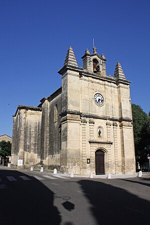
 Parish Church of Saint Martin |
||
Aujargues is a French commune with 846 inhabitants (as of January 1, 2017) in the Gard department in the Occitanie region .
geography
Aujargues is located 13 kilometers northwest of Lunel between Nîmes, 20 kilometers away, and Montpellier, 28 kilometers away . The border with the Hérault department runs a few kilometers to the southwest . The municipality is traversed by the Ruisseau des Corbières and Ruisseau de Font Gaillarde streams . The neighboring municipalities of Aujargues are Souvignargues in the north, Calvisson and Congénies in the east and Villevieille in the south and west.
Culture and history
Church and cemetery
After the old village church had been destroyed in the course of the Huguenot Wars , the decision to build a new church was made in April 1686. Construction work was completed in 1689 and Aujargues received its new church under the name Saint-Martin . Since 1984 this has been one of the Monuments historiques .
Externally, the building has different designs, including a facade in the classic style. Distinctive features of the church are in particular some pilasters , as well as two small pyramids on the roof that frame the bell tower. The inner ceiling forms a ribbed vault , which is a typical element of Gothic architecture. It also contains some arch elements in the Romanesque style. In addition to the main room, the church has three chapels, with each chapel having its own altar .
The communal cemetery was initially in the immediate vicinity of the church, but was declared inadequate in size by a resolution of the local council in 1903. This was followed by a decision to relocate the cemetery in February 1905 and the acquisition of suitable land in June 1906. The cemetery, which was completed in 1908, is around 800 meters outside of the town center.
lock
The castle of Aujargues has existed since the Middle Ages, when it was initially a fortress. In 1306 it came into the possession of Guillaume de Nogaret , who received it as a gift from Philip IV . It remained in the possession of his descendants until 1800, but was badly damaged by arson in the course of the French Revolution on April 1, 1792. The grounds of the castle, which was declared a classified natural monument in 1969, also include a pigeon house built in 1699 .
Pont du Curé
Near the church is the so-called Pont de Curé (Pastor's Bridge), which is an overpass across the street. They connect the rectory with the pastor's garden. It was created in 1866 mainly from limestone. After being destroyed by a truck in 1993, it was rebuilt using a lighter stone.
Population development
| year | 1962 | 1968 | 1975 | 1982 | 1990 | 1999 | 2009 | 2017 |
|---|---|---|---|---|---|---|---|---|
| Residents | 223 | 232 | 295 | 366 | 469 | 673 | 844 | 846 |
Web links
Individual evidence
- ↑ Mairie d'Aujargues , annuaire-mairie.fr
- ↑ Histoire et patrimoine ( Memento of the original from July 28, 2013 in the Internet Archive ) Info: The archive link has been inserted automatically and has not yet been checked. Please check the original and archive link according to the instructions and then remove this notice. , aujargues.fr
