
Montaren-et-Saint-Médiers
| Montaren-et-Saint-Médiers | ||
|---|---|---|
.svg)
|
|
|
| region | Occitania | |
| Department | Gard | |
| Arrondissement | Nîmes | |
| Canton | Uzes | |
| Community association | Pays d'Uzès | |
| Coordinates | 44 ° 2 ' N , 4 ° 23' E | |
| height | 83-274 m | |
| surface | 19.42 km 2 | |
| Residents | 1,434 (January 1, 2017) | |
| Population density | 74 inhabitants / km 2 | |
| Post Code | 30700 | |
| INSEE code | 30174 | |
| Website | http://www.montarenetsaintmediers.fr | |

Montaren-et-Saint-Médiers is a French commune with 1,434 inhabitants (as of January 1, 2017) in the Gard department in the Occitanie region ; it belongs to the Arrondissement of Nîmes and the Canton of Uzès . The inhabitants are called Montarénois .
geography
Montaren-et-Saint-Médiers is about 20 kilometers north of Nîmes . The Seynes River crosses the municipality. Montaren-et-Saint-Médiers is surrounded by the neighboring municipalities of La Bruguière in the north, Saint-Quentin-la-Poterie in the east and northeast, Uzès in the east and southeast, Arpaillargues-et-Aureillac in the south, Serviers-et-Labaume in the west and Belvézet in the northwest.
Population development
| year | 1962 | 1968 | 1975 | 1982 | 1990 | 1999 | 2006 | 2017 |
| Residents | 571 | 518 | 654 | 805 | 1094 | 1236 | 1351 | 1434 |
| Sources: Cassini and INSEE | ||||||||
Attractions
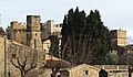
- Remains of the former castle of Montaren-et-Saint-Médiers

Remains of the former castle complex
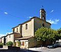
Saint-André et Saint-Médiers church

Chapel in Saint-Médiers
Montaren Castle
_(10).jpg)
.jpg)
.jpg)
