
La Bastide-d'Engras
|
La Bastide-d'Engras La Bastida d'En Gras |
||
|---|---|---|
.svg)
|
|
|
| region | Occitania | |
| Department | Gard | |
| Arrondissement | Nîmes | |
| Canton | Uzes | |
| Community association | Pays d'Uzès | |
| Coordinates | 44 ° 6 ′ N , 4 ° 29 ′ E | |
| height | 154-260 m | |
| surface | 9.85 km 2 | |
| Residents | 196 (January 1, 2017) | |
| Population density | 20 inhabitants / km 2 | |
| Post Code | 30330 | |
| INSEE code | 30031 | |

La Bastide-d'Engras ( Occitan : La Bastida d'En Gras ) is a French commune with 196 inhabitants (as of January 1, 2017) in the Gard department in the Occitanie region . It belongs to the Arrondissement of Nîmes and the Canton of Uzès .
geography
La Bastide-d'Engras is located about 31 kilometers north-northeast of Nîmes and about 31 kilometers east of Alès . The neighboring municipalities of La Bastide-d'Engras are Saint-Laurent-la-Vernède in the north and west, Cavillargues in the northeast, Pougnadoresse in the east, Vallabrix in the south and Saint-Quentin-la-Poterie in the southwest.
Population development
| year | 1962 | 1968 | 1975 | 1982 | 1990 | 1999 | 2006 | 2017 |
|---|---|---|---|---|---|---|---|---|
| Residents | 134 | 133 | 123 | 123 | 134 | 171 | 211 | 196 |
| Sources: Cassini and INSEE | ||||||||
Attractions
- church
- Saint-Jean chapel in Orgerolles from the 15th century
- Orthodox nunnery Solan
- Site fortification
- lock
- Clock tower
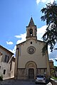
church

View of the castle
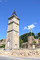
Clock tower

Solan Monastery


Web links
Commons : La Bastide-d'Engras - Collection of images, videos and audio files