Cavillargues
|
Cavillargues Caubilhargues |
||
|---|---|---|

|
|
|
| region | Occitania | |
| Department | Gard | |
| Arrondissement | Nîmes | |
| Canton | Bagnols-sur-Cèze | |
| Community association | Gard Rhodania | |
| Coordinates | 44 ° 7 ' N , 4 ° 31' E | |
| height | 105-262 m | |
| surface | 11.27 km 2 | |
| Residents | 843 (January 1, 2017) | |
| Population density | 75 inhabitants / km 2 | |
| Post Code | 30330 | |
| INSEE code | 30076 | |
| Website | mairiedecavillargues.sitew.com | |
 Mairie Cavillargues |
||
Cavillargues ( Occitan : Caubilhargues ) is a French commune with 843 inhabitants (as of January 1, 2017) in the Gard department in the Occitanie region ; it belongs to the arrondissement of Nîmes and the canton of Bagnols-sur-Cèze . The inhabitants are called Cavillarguais .
geography
Cavillargues is about 22 kilometers west-southwest of Orange . Cavillargues is surrounded by the neighboring communities of Sabran in the north and northeast, Saint-Pons-la-Calm in the east and southeast, Le Pin in the south and southeast, Pougnadoresse in the south, La Bastide-d'Engras in the southwest, Saint-Laurent-la- Vernède in the west and Saint-Marcel-de-Careiret in the northwest.
The municipality is part of the Côtes du Rhône wine-growing region .
Population development
| year | 1962 | 1968 | 1975 | 1982 | 1990 | 1999 | 2006 | 2017 |
| Residents | 525 | 510 | 445 | 492 | 601 | 645 | 744 | 843 |
| Sources: Cassini and INSEE | ||||||||
Attractions
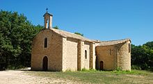
- Hermitage ( Hermitage ) Notre-Dame-du-Saint-Sépulcre, Monument historique
- Right in the center is the Château de Nicolay , a stately building flanked by 2 round towers, with remains of the city fortifications on the back
Web links
Commons : Cavillargues - Collection of images, videos and audio files

