
Gotthard Pass
| Gotthard Pass | |||
|---|---|---|---|
 Hospice and museum on the Gotthard Pass |
|||
| Compass direction | North | south | |
| Pass height | 2107 m above sea level M. | ||
| Canton | Ticino , Uri | Ticino | |
| Watershed | Gotthardreuss , Reuss ( Rhine ) | Foss , Ticino ( Po ) | |
| Valley locations | Andermatt | Airolo | |
| expansion | Pass road | ||
| Built | 1827-1830 | ||
| Winter closure | November – May | ||
| particularities | old road: 13.4 km, maximum gradient: 11.4% |
||
| profile | |||
| Denzel scale | SG 2 | SG 2, SG 3 (old street) |
|
| Ø pitch | 5.5% (659 m / 12 km) | 6.4% (931 m / 14.6 km) | |
| Max. Incline | 9% | 8.8% | |
| map | |||
|
|||
| Coordinates | 686 113 / 157047 | ||

The Gotthard Pass ( Passo del San Gottardo in Italian ) was one of the most important north-south connections across the Alps from the Middle Ages until the construction of the railway and motorway tunnels . The Gotthard axis is the name of the transport axis that is still important today in Europe and leads in a north-south direction over the Gotthard massif or under it. It is the direct traffic connection through the Central Alps, as it only leads over a mountain ridge . For this reason, unlike the pass itself, it is still of great importance for Alpine transit . The passport is named after St. Godehard von Hildesheim .
course
The mountain pass connects the villages of Andermatt in the Urseren valley in the canton of Uri and Airolo in the Leventina valley in the canton of Ticino . The pass is at an altitude of 2107 m above sea level. M.
The Gotthardstrasse, as it is officially called, connects Altdorf and Biasca over a distance of around 110 kilometers . This main road 2 follows the Reuss valley from Altdorf and touches the villages of Schattdorf , Erstfeld , Silenen , Amsteg , Intschi , Wassen , Wattingen and Göschenen . After Göschenen follows the Schöllenen Gorge with the Suworow monument and then the village of Andermatt , a traffic junction. This is where the Gotthard axis and the central east-west axis of the Swiss Alps intersect, connecting the Valais and Goms in the west via the Furka Pass and the Oberalp Pass with Graubünden and the Surselva in the east.
The pass road or main road 2 crosses the main European watershed between the Rhine and Po at the Gotthard pass . It is flanked by the Gotthard line and the mountain lake Lago della Piazza . From the canton border, which lies between Hospental and the Gotthard Pass, it bears the name Via San Gottardo and as such leads into the Leventina . In Airolo it reaches the valley floor. In Piotta it changes its name to Strada Cantonale .
history
.jpg)
Although the Gotthard was known to the Romans as a pass under the name Adula Mons , they hardly used it: paved Roman roads led over the Septimerpass , Reschenpass and Brenner . Although the Gotthard could always be crossed in and of itself, the Schöllenen Gorge further north was an insurmountable obstacle. Finds of Roman coins show, however, that the pass was only used to a small extent. The Schöllenen was mostly bypassed via the Bäzberg or traveled via the Furkapass and Oberalppass , which at the time were at least accessible via a mule track .
A prerequisite for the movement of goods and people over the Gotthard was the opening of the Schöllenen Gorge between Göschenen and Andermatt . The Twärren Bridge was first built around 1220 and the first wooden bridge over the Reuss , the Devil's Bridge, around 1230 . In 1595 this was replaced by a stone one. Robert Schedler dealt with the legend of the establishment of the first path through the Schöllenen Gorge in his historical novel Der Schmied von Göschenen .
The fast transit on the Gotthard was also convenient for the Staufer Emperor Friedrich II , because the possibility of being able to move messengers and soldiers quickly across the Alps was so important to him and his son Heinrich (VII), who reigned as king in Germany , that he did so in 1231 Uri was granted a charter in return for a ransom sum and the deposit of free and secured passage. This made the Uri empire free, which meant that they owed obedience only to the emperor. The cantons of Schwyz and Unterwalden were later given the same status.
Mule track

When the Schöllenen Gorge was made accessible, the ascent of the Gotthard Trail began and continues to this day. In the 13th century it was given a pebbled or paved with granite slabs mule path up to three meters wide, over which around 12,000 people moved annually. However, the mule track was not that wide everywhere, there were numerous bottlenecks. As in the present day, these bottlenecks on the old mule track led to columns that repeatedly brought the trade caravans to a standstill. Nevertheless, the Gotthard Border Trail was considered a comfortable road for the late Middle Ages, and the Gotthard Pass quickly developed into one of the most important Alpine crossings. The names for the pass at that time were Monte Tremulo , Mons Ursarie and Mons Elvelinus .
Numerous contracts of the places on the Gotthard route regulated the mule traffic, the first time in 1237. The Mule Order of 1383, concluded between Uri and the Valle Leventina, already enabled a kind of express freight traffic. Not only did the haulers hold the transport monopoly, they also took care of the maintenance and expansion of the roads. The creation of safe paths was therefore also in their interest, as it enabled them to increase their profits. The hitherto poor area soon grew to a certain degree of prosperity thanks to the mule system. The military also quickly accepted the new passport: As early as 1240, Schwyz soldiers rushed over the Gotthard to the aid of their emperor near Faenza .
Numerous celebrities traveled over the Gotthard early on, including many church princes. The first reliable news about the use of the pass comes from Albert von Stade , a Benedictine abbot from the diocese of Bremen, who in 1236 chose this route for a pilgrimage on his way back from Rome to Germany.
Some of the travelers left behind informative and dramatic travel reports, such as the Samland bishop Dietrich of Cuba, who wrote in his account book on March 16, 1473: .. over the Gothart a nasty evil when I (not) changed byn all myn leptage . The Oxford chronicler Adam de Usk, who traveled the Gotthard in March 1401 in a sleigh pulled by oxen, reported that he had his eyes blindfolded in the most dangerous places in order not to have to look into the deep abysses.
meaning

Barely fifty years after the Devil's Bridge was built, the Gotthard had become so important that the Bishop of Chur exempted his colleagues in Lucerne (1278) and Zurich (1291) from customs in order to maintain the frequencies on the Septimer .
The Gotthard tariffs concentrated in Lucerne from Hospental to Reiden were a main source of income for the Habsburg administration. It was the Habsburgs who promoted the expansion of the Gotthard Trail in the first hundred years. Before that, the Gotthardweg was more or less a series of more or less well-maintained and sometimes very old municipal roads.
Already at the beginning of the 15th century, around 10,000 people and 9,000 pack animals crossed the pass every year. Even if the summer months favored traffic over the Gotthard, the winter months were more lucrative for the mule-haulers. In winter they could use a sleigh pulled by two oxen, with which they could transport up to 600 kilograms, four times as much as in summer. In 1500 around 170 tons of goods were transported over the Gotthard. The journey from Flüelen to Bellinzona took around 30 hours on foot .
The Thirty Years' War made the Gotthard lose its importance for a long time. The revenue from the customs offices in Basel and Lucerne, which at the end of the war in 1648 was barely 20% of 1619, serve as a yardstick. At that time Germany was too bled out for Italy's trade with Germany to flourish. That changed with the conclusion of peace and in 1655 new records were set in trade.
During the Second World War , the Gotthard fortress was expanded at the top of the pass and remained in service until 1998. These included the Sasso da Pigna fortress at the top of the pass as well as the Foppa Grande fortress and Gütsch fortress , which secured the access roads.
hospice


A chapel is said to have stood at the top of the pass early on. It is not known who built it and when. During excavations in the cellar of the old hospice on the top of the pass, their foundation walls were found, which at least go back to the Carolingian era; another predecessor is conceivable.
The chapel and a sust at the top of the pass are first mentioned in a peace treaty concluded between Urseren and Livinen on August 12, 1331 following border disputes . The Milanese Archbishop Galdinus is said to have consecrated the chapel to Saint Godehardus in 1230 (according to Liber notitiae Sanctorum Mediolani ), after whom the pass is named. But there are also indications that the monks of Disentis maintained a chapel or accommodation here decades before and also worshiped Saint Godehardus there.
Soon a hospice ( refuge ) was built as a hostel for the numerous pilgrims to Rome and other travelers , which was enlarged in 1431/32. In the 17th century, Archbishop Federico Borromeo of Milan had the hospice expanded and a priestly apartment added. From 1685 the inn was run by Capuchins who were given special permission to wear shoes because of the extreme weather.
A report has come down to us from the end of the 18th century in which the hospitality of destitute travelers is reported. So the landlord had to give everyone a piece of bread, some lean cheese and a little sweet wine, and at lunchtime there was also a “lined soup”. They also gave night camps and, if necessary, care. Every year around 4,000 poor people are said to have been fed in this way.
During fighting between the Russians and the French, the hospice was destroyed in 1799 and the Capuchins were recalled, reinstated in 1837 and finally recalled in 1841. In 1830 the building passed to the Canton of Ticino, which renovated it in 1834 and had a hotel and customs building built in 1838. From then on, the hospice was looked after by Felice Lombardi from Airolo, whose family ran there until 1972. In 1866, Lombardi's son opened the Hotel Monte Prosa next to the hospice in order to be able to entertain distinguished guests in an appropriate manner. In 1905 the hotel burned down, but was immediately rebuilt. In the former sust opposite the hospice there is now a restaurant and the San Gottardo Museum. The hospice was gutted in 2005 as a result of an architecture competition by the architects Quintus Miller and Paola Maranta above the first floor. The gable was raised and next to the concrete staircase a wooden structure was built that reached under the roof.
First mail
Couriers, messengers, runners and warriors have been running again and again since the opening of the Gotthardweg, but without a fixed timetable. They carried messages between monasteries, universities and royal courts. The federal messengers, the professional runners, wore a colorful uniform and coat of arms, a messenger box, a spit and a short sword. They were official officials and were not allowed to be harassed. The authorities were obliged to help them.
From the 15th century on there was reports of an increase in mail traffic over the Gotthard. The Roman-German King and later Emperor Maximilian I is said to have had a regular messenger line set up by his postmaster Franz von Taxis in 1494 . This could not have lasted long, because when the Swabian War broke out in 1499 , the Confederates fought against Maximilian I. In 1563 at the latest, there was a postal line connecting Milan with Basel and mentioned in the postal travel book of the Genoese courier master Giovanni da l'Herba.
The first federal postal service was created in 1615 by the Zurich brothers Hess, who, on behalf of Zurich merchants and with official approval , had set up the first post office in the house at the Red Gate in Zurich . From October 5, 1615, they sent a runner over the Gotthard to and from Bergamo once a week . In the following years, other messenger services were set up, for example from 1653 to 1682 by Diego Maderni in Lugano , whose mounted couriers covered the route between Lucerne and Milan in four days. Probably the best-known ran the Bernese councilor and postal entrepreneur Beat von Fischer , who also owned the mail shelf on the Simplon Pass , from 1693 onwards. He set up a mounted post over the Gotthard, which lasted until 1832.
In order to keep mail and goods traffic going in winter, an ox was driven through the snow with a heavy tree trunk hanging on a rope in order to press the snow somewhat firmly so that it could be used by sledges. When the snow was too deep for the animals, shovel workers were used. The route of the Gotthardweg was found in the same way as it is today: in summer long wooden poles were stuck to the side of the road. The method of clearing snow by ox and tree trunk was used until motorized snow clearing vehicles came into use in the 20th century.
First expansion

The old mule track from the Middle Ages has been expanded in sections since its inception, so that from the end of the 18th century it could also be used by the Gotthard Post carriages. Towards the end of the 17th century, the Gotthardweg was paved with granite pebbles and gneiss slabs and turned into a street. The path was widened to five meters wherever possible.
It can be assumed that with this construction a modest traffic was also possible for the first time, which, however, still excluded the route over the pass and the Schöllenen. In the Tremola, the mule path was laid out in the form of a stone stepped path, a method popular in earlier times to compensate for differences in height quickly and safely, as it was possible for the pack animals like porters to cover the path in a direct line.
Car rides were hardly possible here, even if there was possibly another path parallel to the stepped path, which was significantly longer, but managed without steps due to a smaller gradient. The stepped path is still reported at the end of the 18th century, for example in an engraving from 1780, from the time from which the first reports of a Gotthard crossing by car are known.
In 1775 an Englishman, the geologist Greville, drove over the Gotthard for the first time. He had insisted on traveling on four wheels. To accomplish this, he was accompanied by 78 men who dismantled the carriage at the most difficult points, carried it around the obstacle and reassembled it. Greville was only an exception, however, most travelers preferred horse or sedan chair or crossed the Gotthard on foot, like Johann Wolfgang von Goethe , who crossed the Gotthard three times. Despite all the difficulties, travelers describe the traffic, especially the movement of goods, as extremely heavy. Nevertheless, it was to take a few more decades until conditions on the Gotthard improved and the old mule track was replaced by a new road.
Remnants of the old mule track can still be seen in some places today, for example near the hospice or the chapel of the dead. The remains of the old mule tracks are currently being expanded into a historic hiking trail. The IVS is in charge - the inventory of historical traffic routes in Switzerland .
First Street

With its medieval standard, the Gotthardweg was less and less able to cope with the increasing demands of traffic. Already at the end of the 18th century it became clear that the old Gotthardweg had to be expanded. In 1772 the Brennerstrasse was already expanded and in 1805 the Simplon followed.
Initially, however, this did not harm the Gotthard. The traffic at this time increased strongly and Brenner and Simplon were in enemy hands. After the Congress of Vienna in 1815, however, the situation looked different and traffic took the faster routes - and that was no longer just the Gotthard. Graubünden reacted quickly by pushing ahead with the construction of the roads over the San Bernardino Pass with Ticino and Splügen with Austria on the south side in 1818 . The canton of Uri, which had previously not considered expansion of the Gotthard to be so important, now hastened to press ahead with the expansion. Only at first he was of the opinion that repairs to the mule track were sufficient; they had become necessary anyway after the destruction caused by the fighting of the Russian general Suvorov against the French in 1799.
In the first third of the 19th century, however, traffic over the Gotthard slackened; the new routes over the San Bernardino Pass, Splügen and Simplon were tough competition because of their better development. It soon became clear that the Gotthard also needed an easily navigable road, with the canton of Ticino in particular being the driving force.
After the cantons of Lucerne, Solothurn, Ticino, Basel and Uri had pledged four million francs, the rural community of Uri decided on May 3, 1818 to build a route from Amsteg to Göschenen. To finance this, a tariff increase was decided for a period of 35 years. On June 6, 1820, the company of Cirillo Jauch , an Uri resident living in Ticino, began construction work, which was completed in 1826. Uri had but rushed the first best contractors selected, which works poorly executed: After a few years slipped routes, and a bridge collapse, and so many sections had subsequently under the direction of barely twenty years Altdorfer engineer Karl Emanuel Müller again be built . Under his direction, the difficult section from Göschenen to Hospental was built from 1826 to 1830. At the same time, the Ticino engineers Columbara from Ligornetto built the road from Hospental to the canton border. By 1830, the demanding route between Giornico and the canton border was completed under the direction of the Ticino engineer Francesco Meschini .
On the new Gotthardstrasse, which was 5.5 to 7.5 meters wide, even heavy trucks could now comfortably drive and cross each other, and as early as 1831 900 carriages were rolling over the pass. In the middle of the 19th century, the Gotthardstrasse was in reasonably good condition, but the old freight haulers' cooperatives were an obstacle to well-functioning pass traffic because they still had the transport monopoly. Because the haulers were also farmers who had to do their farm work, there were always delays and traffic jams, especially in summer. The professional transport companies, which often came from the lowlands, profited from this and subverted the old haulage system so badly that it soon fell apart.
Time of the stagecoach
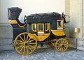
Gotthard carriage for ten passengers in the courtyard of the National Museum in Zurich

Ticket 1881

Stagecoach in front of Wassen , 1845

Gotthard post in a sleigh, 1873

«The Gotthard Post»; Painting by Rudolf Koller , 1873


After the opening of the new road in 1830, a through car drove three times a week in both directions between Flüelen and Chiasso. Small single-horse carriages with two to three seats were used. The great time of the Gotthard Post began in 1842 when a five-horse, ten-seater carriage drove in both directions every day. The journey from Como to Flüelen took just under 23 hours.
In 1849 the postal system was transferred from the cantons to the federal government. In the same year a second daily course was set up, again with a five-horse, ten-seater carriage, the standard stagecoach of the Swiss Post at the time.
In winter the carriages were replaced by columns of one-horse two-seater sleighs. On both sides of the pass 100 men had to stand ready to clear the snow. In 1848, after the formation of the Swiss federal state, the collection of road duties and cantonal fees was banned. Under the direction of the Swiss Post, services have been improved and travel times have been shortened. In 1857, over 29,000 postal travelers used the Gotthard, while the three Graubünden passes, San Bernardino, Splügen and Julier, only had 19,117 postal travelers. Despite the large number of travelers, the express mail was largely a loss-making business, even though the 50-hour carriage ride from Basel to Milan cost 68.60 francs, which was a huge amount at the time.
In the autumn of 1881, before the switch to winter sleigh operation, the last stagecoach drove over the pass, the conductor (not postillon) was the legendary Alois Zgraggen . In the following spring, sled operations were stopped.
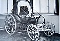
Two-seater Gotthard mail van as used from 1830

Departure of the stagecoach in Flüelen, 1820

Alois Zgraggen , lithograph

The last Gotthard post on September 13, 1921 above Airolo


When the Gotthard Railway opened in 1882, the Gotthard Road lost its importance overnight for a few decades. While only 15,000 travelers had crossed the pass before the Gotthard was expanded in 1820, it was more than 72,000 in the record year 1875. In the last full year of operation, 1881, there were 58,496. From 1881, mail was transported through the Gotthard tunnel, which was finished in shell, so that the arduous and dangerous journeys over the pass were no longer necessary.
In 1909 another attempt was made to revive the Gotthard in the summer with the reintroduction of a stagecoach course between Andermatt and Airolo, but the courses were only of local importance. In autumn 1921 a horse-drawn mail carriage drove over the Gotthard for the last time. In the whole of 1921, 188 passengers were carried. The Car-Alpin, the first Postbus, was already on the road in the next year.
Car traffic
The era of the automobile had begun: the first automobile is said to have reached the Gotthard Pass as early as 1895. In 1901, the French engineer I. Arraou reported his 3,000-kilometer round trip with the crossing of the Gotthard as the highlight. He drove a De Dion-Bouton weighing 350 kilograms with 3.5 hp. In Lucerne he procured four 10-liter canisters of gasoline, fearing that he would not find gasoline or mechanics for repairs as far as Italy. From Göschenen he shipped most of the luggage by train to the Italian border in order to save weight for the ascent. The car was pushed over the Teufelsbrücke because of the thick fog, and a passenger with a lantern in front of the car went to Hospental. Because the engine was too weak, the vehicle had to be pushed through the steepest passages. On the other hand, on the descent towards Airolo, the leather brake pads were burned after just a few minutes. The driver did everything possible to increase the braking force: a tree trunk fastened with wire was supposed to slow down the journey just like the convertible top, which was opened as a "brake sail" in a headwind. The descent to Airolo took eight hours.
The German poet Otto Julius Bierbaum's drive over the Gotthard in July 1902 is also documented in literature. For his trip to Italy, accompanied by his wife, Bierbaum received an 8 hp red Adler Phaeton and a driver named Louis Riegler from the Berlin publisher August Scherl . In 1902 the Gotthard was supposedly the only Swiss passport for which use with motor vehicles was not prohibited. The tour company covered the 136-kilometer route from Bellinzona to Brunnen in nine hours. The anecdotal climax of this trip, however, only reached on the descent in Göschenen: A police officer blocked the way and ordered to get out. Bierbaum was informed that the police in Andermatt had sent a telegram: “Automobile drove through here; impossible to stop. Provides it and decrees according to the law! " It turned out that the canton of Ticino had allowed the Gotthard to be driven on, but not the canton of Uri on the Schöllenen. Bierbaum had to pay a fine of 20 francs because he had not put an ox in front of his vehicle in Andermatt, after which he was allowed to continue on his way.
Cars and the rise of mass tourism led to an increased volume of traffic on the Gotthard Pass after the Second World War at the latest, and it became clear that the old and winding Gotthardstrasse was less and less able to meet the new demands, although between 1937 and 1941 the natural surface of the Tremolastrasse and other sections was through one Had replaced the surface with granite stones. From 1924, cars could be taken through the tunnel as luggage for the first time; In 1930 there were already around 3,600 vehicles per year. Nevertheless, a new road had to be found.

Bierbaum shortly before the Gotthard Hospice in 1902

Bierbaum at the top of the pass
The tremola 1928

Car loading on the Gotthard in the 1930s

The Schöllenen 1953
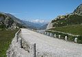
The old road north of the hospice


The new street
| Gotthard pass road | ||||||||||||||||||||||||||||||||||||||||||||||||||
|
||||||||||||||||||||||||||||||||||||||||||||||||||


From 1953, Uri began to fully develop Schöllenenstrasse. The Urnerloch was expanded and a new Devil's Bridge was built. In the summer of 1967 the first part of the new Tremolastrasse could be opened; the rest of the Tremola road could only be used in 1977. The new street with its new line, the thirteen bridges, a tunnel and its long avalanche galleries bypasses the old Tremola street on a large scale. In the summer of 1983, the last section of the new Gotthardstrasse was the Andermatt bypass as part of Hauptstrasse 2 . The old Tremola road between the top of the pass and Motto Bartola forms the main road 561.
From 2009 to 2011 the tremola was extensively restored with lots of concrete, which was criticized by art historians and the Federal Roads Office.
But this new Gotthard road was only an interim solution, especially since the pass is closed for a few months in winter. It soon became apparent that the construction of a vertex tunnel was inevitable. And so, after less than two decades, the new Gotthardstrasse also lost its importance, when a winter-safe connection was created under the Gotthard with the opening of the motorway tunnel on September 5, 1980.
The Gotthard axis today

With the opening of the Gotthard Railway in 1882, the increase in traffic on this route, which continues to this day, began. Today it consists of both a railway line and a motorway . The Gotthard axis is of central importance in European north-south traffic and is therefore often overloaded. There is also talk of the Gotthard axis in the larger European traffic context. But the core begins in the north, on the southern part of Lake Lucerne . It leads through the Urner Reuss Valley over or through the Gotthard Pass into the Leventina down to Biasca in the south.
The St. Gotthard Museum next to the hospice conveys the importance and influence of the pass road.
telecommunications

The Gotthard was also used by the post and telecommunications system: as early as 1852, an electrical overhead line for telegraphy ran across the Gotthard. In 1882 it was replaced by a cable in the railway tunnel. In 1900 a telephone cable was laid parallel to this . In 1979 this was replaced by a twelve-core coaxial cable .
tunnel
The Gotthard Tunnel of the Gotthard Railway was built from 1872 to 1882 . Mostly Italian guest workers were employed. 177 men died while working on the tunnel, including the project engineer Louis Favre . The newly built railway line ensured an economic upswing in Ticino. A memorial to the victims of the railway tunnel construction, created by the artist Vincenzo Vela , is in Airolo.
The Gotthard road tunnel was built from 1970 to 1980 and opened on September 5, 1980. It is the heart of the Swiss national road A2 from Basel to Chiasso and thus the shortest European motorway connection between Hamburg and Sicily . On October 24, 2001, a collision between two trucks led to a fire disaster in the tunnel, in which eleven people died.
At the end of 2016, the Gotthard Base Tunnel went into operation, the new rail tunnel between Erstfeld and Bodio and the core of the New Alpine Transversal Railway (NEAT) .
Wind turbines
Five Enercon E-92 wind turbines will be erected at the top of the pass ( Parco eolico del San Gottardo ). Together they have an installed capacity of 11.75 megawatts and are expected to generate 16 to 20 gigawatt hours of electricity annually, as much as a small hydropower plant. The wind turbines have 98 meter high masts and a rotor diameter of 92 meters. They are to be inaugurated in October 2020. There are power lines nearby, for example to the Lucendro power station , which can absorb the electricity produced.
photos
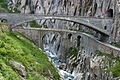
The old and the new Devil's Bridge in the Schöllenen Gorge
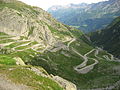
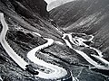
The old pass road in Val Tremola

The north ramp with the Schöllenen Gorge

Stagecoach, 2013


Quote
"
So always rising, you come to the heights
Des Gotthard, where the lakes are Ewg'en
The of the sky streams itself fill
There you farewell take from the German earth,
And merry run brings you one of other power
into Italy down, you the promised"
literature
- Marianne Burghalter and Christian Sumi (eds.): The Gotthard, Il Gottardo . Scheidegger & Spiess, Zurich 2016, ISBN 978-3-85881-503-3 .
- Mario Fransioli: Sankt Gotthard and his hospices. (= Swiss art guide. No. 317). Edited by the Society for Swiss Art History. Bern 1994, ISBN 3-85782-317-8 .
- Rudolf Laur-Belart : Studies on the opening history of the Gotthard Pass with an investigation of the Stiebende Bridge and the Devil's Bridge . Art. Institut Orell Füßli [commission publisher], Zurich 1924.
- Karl Franz Lusser: Fifteen views of the new St. Gotthards Street from the St. Gotthard Hospice to Lugano. Drawn and etched from nature by Joseph Meinrad Kälin, Jakob Suter; together with a description by Mr. Karl Franz Lusser. Heinrich Füssli, Zurich 1833. (digitized version)
- Karl Lüönd : Our Gotthard. Ringier, Zurich 1980, ISBN 3-85859-137-8 .
- Hans Peter Nething: The Gotthard. Ott Verlag, Thun 1990, ISBN 3-7225-6338-0 .
- Werner Meyer : 1291 The story - the beginnings of the Confederation. Silva-Verlag, Zurich 1990.
- Editor: Gotthard Pass. In: Historical Lexicon of Switzerland . August 30, 2016 .
- B. Richter: Natural and anthropogenic landscape factors in the Gotthard area. Freiburg im Breisgau 1996.
- Helmut Stalder: Gotthard. The pass and its myth. Orell Füssli, Zurich 2016, ISBN 978-3-280-05617-2 .
- Arthur Wyss-Niederer: Sankt Gotthard, Via Helvetica. Edition Ovaphil, Lausanne 1979.
Movie
- Life on the Gotthard . Documentation by Jérôme Porte and Béatrice Mohr.
Web links
- Literature on the Gotthard Pass in the catalog of the German National Library
- Gotthard Pass on the ETHorama platform
- The gradient of the pass road from Hospental to the top of the pass
- The gradient profile of the new pass road from Airolo to the top of the pass
- The gradient of the Via Tremola from Airolo to the top of the pass
- Driving on the Gotthard Pass by motorcycle and car
Individual evidence
- ↑ Editor: Gotthard Pass. In: Historical Lexicon of Switzerland .
- ↑ Genealogical library research at de.geneanet.org, accessed on 18 December 2018
- ↑ Sunday newspaper of November 14, 2010, p. 97.
- ^ Joseph Rübsam: An international postal course book from the year 1583. In: L'Union Postale. 1900, p. 98.
- ↑ Val Tremola at ethorama.library.ethz.ch/de/node
- ↑ Hans Peter Nething: The Gotthard. Ott Verlag, Thun 1990, p. 49
- ↑ Ulrich Neumann: Gotthard Pass - from the mule track to the high-speed road. In: Planet Knowledge. February 9, 2011, accessed on July 22, 2013 : “As early as 1895, a Peugeot Quadricycle is said to have been the first vehicle with a gasoline engine to climb the pass. [...] After that there were always daring people who also wanted to make it. "
- ↑ I. Arraou: Le passage du Saint-Gothard en voiturette automobile. In: Le Génie civil: revue générale des industries françaises et étrangères. June 15, 1901, pp. 111–113 , accessed May 5, 2016 .
- ^ Otto Julius Bierbaum : A sensitive journey in the automobile in the Gutenberg-DE project
- ↑ List of the main streets
- ^ Article on Swiss television ( Memento of the original from July 14, 2014 in the Internet Archive ) Info: The archive link was inserted automatically and has not yet been checked. Please check the original and archive link according to the instructions and then remove this notice.
- ↑ St. Gotthard Museum
- ^ Exhibit in the National Gotthard Museum.
- ↑ Helmut Stalder (text), Christoph Ruckstuhl (pictures): The wind turbines on the Gotthard are as big as those outside in the North Sea. But here the rotor blades are heated so that no ice forms. In: Neue Zürcher Zeitung . August 4, 2020, accessed August 7, 2020 .
- ^ Friedrich Schiller: Wilhelm Tell . 1st edition. JG Cotta'sche Buchhandlung, Tübingen 1804, p. 238-239 ( Wikisource : pp. 238 , 239 ).
- ↑ ard.de , broadcast a. a. on 3SAT December 2, 2015 9:05 p.m.
Ächerli • Agites • Aiguillon • Albis • Albula • Balmberg • Benkerjoch • Bernina • Böhler • Bözberg • Breitehöchi • Brünig • Buechenegg • Bürersteig • Chall • Challhöchi Pass • Champex • Chasseral • Chatzenstrick • Chilchzimmersattel • Croix • Croix • Croix de Coeur • Eichhöhe • Étroits • Etzelpass • Flüela • Forclaz • Furka • Ghöch • Givrine • glass • Glaubenberg • Glaubenbielen • Gottschalkenberg • Grimsel • Grosse Scheidegg • Gr.St.Bernhard • Gurnigel • Haggenegg • Hahnenmoos • Heitersberg • Hilferen • Hirzel • Hirzel Höhi • Hulftegg • Ibergeregg • Jaman • Jaun • Julier • Kerenzerberg • Klausen • Kunkels • Lein • Lenzerheide • Livigno • Lukmanier • Maloja • Marchairuz • Mollendruz • Mont Crosin • Monte Ceneri • Mont d'Orzeires • Montvoie • Morgins • Mosses • Mutschellen • Neggia • Nufenen • Oberalp • upper Hauenstein • Oberricken • oven • Orn • Passwang • Pierre Pertuis • Pillon • Planches • Pontins • Pragel • edge crossing • Rangiers • rates • Rengg • crocheted • Roches • 'groups • R üsler • Saanenmöser • Salhöhe • San Bernardino • Sanetsch • Santelhöchi • Sattel • Sattelegg • Schafmatt • Schallenberg • Schelten • Schönau • Schufelberger Egg • Schwägalp • Schwarzenbühl • Siblingerhöhe • Simplon • Splügen • St. Anton • St. Gotthard • St. Luzisteig • Staffelegg • Stoss • Susten • Tourne • Tronc • Umbrail • Unterer Hauenstein • Front Höhi • Vue des Alpes • Wasserfluh • Weissenstein • Wildhaus • Wissegg • Wolfgang