
Emmelsbüll-Horsbüll
| coat of arms | Germany map | |
|---|---|---|

|
Coordinates: 54 ° 49 ' N , 8 ° 41' E |
|
| Basic data | ||
| State : | Schleswig-Holstein | |
| Circle : | North Friesland | |
| Office : | Südtondern | |
| Height : | 0 m above sea level NHN | |
| Area : | 35.73 km 2 | |
| Residents: | 883 (Dec. 31, 2019) | |
| Population density : | 25 inhabitants per km 2 | |
| Postcodes : | 25924, 25899 | |
| Area code : | 04665 | |
| License plate : | NF | |
| Community key : | 01 0 54 166 | |
| LOCODE : | DE 72D | |
| Office administration address: | Marktstrasse 12 25899 Niebüll |
|
| Website : | ||
| Mayor : | Walter Sieger (ADW) | |
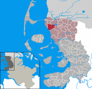
| Location of the municipality Emmelsbüll-Horsbüll in the district of North Friesland | ||
  |
||

Emmelsbüll-Horsbüll ( Danish Embsbøl-Horsbøl , Frisian : Ämesbel-Hoorbel ) is a municipality on the North Sea coast in the district of North Friesland in Schleswig-Holstein . It was created in 1974 from the merger of the two communities Emmelsbüll and Horsbüll.
geography
Emmelsbüll-Horsbüll is a scattered settlement which, in addition to the two parishes , the street village of Emmelsbüll and the hall- like Alt-Horsbüll located on a large warft , also includes several smaller towns.
history
The first traces of settlement date from the migration period.
Horsbull
Horsbüll, today the smaller of the two places, was first mentioned in 1231 in the Waldemar-Erdbuch as the center of what was then Horsbüllharde . The church dates from this time. Storm surges repeatedly forced the dike to be moved back. In this way, the western part of the Horsbüllharde disappeared over the centuries, so that the Horsbüller Church has stood directly on the dike since 1805. Today, however, behind it is no longer the North Sea , but the Friedrich-Wilhelm-Lübke-Koog . In addition to the hall-like old village center around the church, Horsbüll includes the street villages of Neu-Horsbüll, Humwerthusum and Diedersbüll.
The name explains a legend, according to which a landowner was rescued from the floods by his horse (= Hors ) during a large storm surge at the place where the Horsbüller Marienkirche stands today . Büll is often represented in the Frisian region and means settlement, village. JA Petersen has other versions of the origin of the place name.
Emmelsbull
Emmelsbüll on the southern edge of the Wiedingharde was also mentioned for the first time in the Waldemar Erdbuch. In addition to the village center with the church, it consisted of several farms on terps, including the formerly aristocratic Toftum estate . The area belonging to the municipality expanded through the extraction of the Kleiner Emmelsbüller Koog in 1554 and the Gotteskoog in 1566. From the 1950s the village was enlarged by several new development areas. In Südwesthörn, where today a pumping station drains the water collected in the Sielzug ( Alter Sielzug ) from the Gotteskoog and the Alter Wiedingharder Koog into the North Sea, there was a small port until the 20th century.
Church building
On February 1, 1974, the former municipalities of Emmelsbüll and Horsbüll were merged to form the new municipality of Emmelsbüll-Horsbüll.
Population development
| 1845 | 1885 | 1900 | 1925 | 1933 | 1939 | 1961 | 1970 | 2004 | 2008 | 2011 | |
|---|---|---|---|---|---|---|---|---|---|---|---|
| Horsbull | 436 | 418 | 413 | 410 | 400 | 646 | 394 | 449 | |||
| Emmelsbull | 797 | 862 | 792 | 750 | 819 | 1086 | 957 | 947 | |||
| total | 1233 | 1280 | 1205 | 1160 | 1219 | 1732 | 1351 | 1396 | 1051 | 984 | 936 |
Sources: 1845, 1900, 1885, 1925, 1933 and 1939, 1961 and 1970, 2008
Explanations:
- The increase between 1933 and 1939 can be explained by the establishment of camps of the Reich Labor Service (RAD).
politics
Community representation
Of the eleven seats in the municipal council, the AAE-H community of voters had five, the ADW three, the KWH two and the SPD one seat since the 2008 local elections .
The election on May 26, 2013 had the following results: the voting communities ADW, AAE-H and KWH each received three seats and the SPD two seats. The turnout was 55.7 percent.
Of the eleven seats in the municipal council, the ADW electoral community received five seats, the AAE-H electoral community four seats and the KWEH two seats as a result of the local elections on May 6, 2018 . The respective shares of the votes were: ADW 49 percent, AAE-H 32.2 and KWEH 18.9 percent. The turnout here was 55.9 percent
mayor
Walter Sieger (ADW) was elected mayor for the 2013–2018 election period. He succeeded Günther Carstensen (AAE-H), who was in office for 15 years.
Community partnerships
The partner community has been Unteregg in the Unterallgäu district since 2000 .
Culture and sights
With the Rimbertikirche from 1768 Emmelsbüll has a church worth seeing.

Rimberti Church in Emmelsbüll

Vault and organ

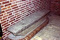
Lead-coated baptismal font
Old lintel with incised drawings


Marienkirche
The Horsbüller Marienkirche from the early 13th century is the oldest church in the Wiedingharde. Today it is right next to the dike, which was set back in 1802. The tower replaced a previous one that had burned down in 1897.
The granite font is perhaps even older than the church . The community was quite wealthy. Before the Reformation it had three Gothic carved altars. In 1780 these were torn down and replaced by the baroque altar. The cover of the baptism was decorated with the figures of the apostles from one of the old altars. The pulpit is a donation from the then dikemaster from 1655 and is attributed to Berend Cornelissen from Husum. The inventory also includes figures of apostles and a crescent moon Madonna, early modern stalls with doors and carved cheeks and a larger than life triumphal cross .

Marienkirche in Horsbüll

Cheek from the Horsbüller Church with the name of the owner

Cover of the font


Economy and Infrastructure
The community is dominated by agriculture, but the main sources of income are a mussel processing company and wind turbines . Similar to Galmsbüll, there is a community wind farm project .
Many residents make a living from tourism , be it by renting out holiday apartments , or through jobs on Sylt .
During the dike heightening of the Friedrich-Wilhelm-Lübke-Koog, clay was removed from fields, as the nature conservation law, clay removal, i.e. H. Dredging of the tidal flats in front of the dike is no longer allowed. Where the clay was removed, there is now a lake plateau that is increasingly used for tourism (swimming area, fishing pond) and is also accepted as a resting place by migratory birds.
A station on the Marschbahn ( Emmelsbüll ) existed until the 1980s . As in many other villages, the infrastructure has been severely curtailed in recent decades.
Landesstraße 6 runs through Emmelsbüll-Horsbüll from the Danish border to Ost-Bordelum to Bundesstraße 5 .
Education, schools
On May 11, 1967, the new school building, which replaced the old school opposite the church, was inaugurated as the Emmelsbüll-Horsbüll- Marienkoog Village Community School . The new building also included a gym, an outdoor swimming pool and a caretaker's apartment. In 1977 the main school was relocated to Neukirchen due to the declining number of pupils . The primary school students from Klanxbüll and Friedrich-Wilhelm-Lübke-Koog were enrolled here. In 1983 the last secondary school class was dismissed. The preliminary class established in 1973 was dissolved in 1998. Due to the further decline in the number of pupils, the school was closed at the end of the 2009/2010 school year.
The primary and regional school is located in Neukirchen. Secondary schools are located in Niebüll .
Southwest Horn

The Südwesthörn bathing area is located on the outer dike south of the Südwesthörn pumping station ( ⊙ ) . Here you will find a lawn with beach chairs, a public shower and a jetty into the Wadden Sea . Originally there was a small port at this point, but this is still shown on the current nautical charts. Up until 1977, there was a sewer in the form of a (closed) stand column at the site of the south-west Hörn pumping station . When the tide was low, the gates for drainage of the inland were opened; when the tide was high, they were closed. The pumping station Südwesthörn has four electrically operated pumps with a total delivery rate of 12,000 liters / second.
From here, guided mudflat hikes into the Wadden Sea National Park take place.
Personalities associated with Emmelsbüll-Horsbüll
- Christian Mommsen (1868–1927), born in Toftum, qualified farmer and animal breeding director in the province of Saxony
- Friedhelm Rathjen (* 1958), author and translator, lives and works in Emmelsbüll-Horsbüll.
- Christian A. Schwarz (* 1960), Protestant theologian and publicist, lives in the community.
- Gunnar Uldall (1940-2017), Senator for Economics and Labor in Hamburg, lived temporarily in Horsbüll and donated a bronze plaque with the ten commandments as a legacy to the Marienkirche in Horsbüll
literature
- JA Petersen: Walks through the Duchies of Schleswig, Holstein and Lauenburg, Volume 3 . Printed by C. Wäser, 1839. Complete edition on Google Books, approx. Pp. 422–430
- Werner Kambeck: The water solution Südwesthörn . Nordfriisk Instituut, Bredstedt 1977, ISBN 3-88007-066-0 .
Web links
Individual evidence
- ↑ North Statistics Office - Population of the municipalities in Schleswig-Holstein 4th quarter 2019 (XLSX file) (update based on the 2011 census) ( help on this ).
- ↑ Settlement history ( Memento from July 22, 2011 in the Internet Archive )
- ↑ JAPetersen: Walks through the Duchies of Schleswig, Holstein and Lauenburg, Volume 3 . 1839, p. 426 f .
- ↑ a b Federal Statistical Office (ed.): Historical municipality register for the Federal Republic of Germany. Name, border and key number changes in municipalities, counties and administrative districts from May 27, 1970 to December 31, 1982 . W. Kohlhammer GmbH, Stuttgart / Mainz 1983, ISBN 3-17-003263-1 , p. 182 .
- ^ W. Lesser: Topography of the duchy of Schleswig, Volume 1–2 . C. Schröder & comp., 1853 ( limited preview in Google book search).
- ^ Municipal directory 1900. Retrieved June 10, 2010 .
- ^ Michael Rademacher: German administrative history from the unification of the empire in 1871 to the reunification in 1990. tondern.html. (Online material for the dissertation, Osnabrück 2006).
- ↑ North Statistics Office: Population of the communities in Schleswig-Holstein on December 31, 2008 (PDF file; 539 kB)
- ↑ Web editor: Results of the 2013 municipal elections in the South Tondern office. In: www.amt-suedtondern.de. Office Südtondern, accessed on June 22, 2013 .
- ↑ Web editing: Result of local elections Emmelsbüll-Horsbüll 2018. In: www.amt-suedtondern.de. South Tondern Office, accessed on November 8, 2018 .
- ↑ With a narrow majority in the Husumer Nachrichten office of July 13, 2013, accessed on July 14, 2013
- ↑ School portrait School portrait ( Memento of the original from December 15, 2015 in the Internet Archive ) Info: The archive link has been inserted automatically and has not yet been checked. Please check the original and archive link according to the instructions and then remove this notice.
- ^ Off for Primary School Emmelsbüll-Horsbüll Nordfriesland Tageblatt of February 4, 2010
- ↑ Festschrift for the inauguration of the pumping station Südwesthörn, Werner Kambeck, Ed. Nordfriisk Instituut, Bredstedt, ISBN 3-88007-066-0
- ↑ The seabed meets the horizon "De Wattenlöpers" - professional association of mudflat guides in the Schleswig-Holstein Wadden Sea National Park
Achtrup | Ahrenshöft | Ahrenviöl | Ahrenviölfeld | Alkersum | Almdorf | Arlewatt | Aventoft | Bargum | Behrendorf | Bohmstedt | Bondelum | Bordelum | Borgsum | Bosbull | Braderup | Bramstedtlund | Bredstedt | Breklum | Dagebüll | Drage | Drelsdorf | Dunsum | Elisabeth-Sophien-Koog | Ellhöft | Emmelsbüll-Horsbüll | Narrow Sands | Fresendelf | Friedrich-Wilhelm-Lübke-Koog | Friedrichstadt | Galmsbüll | Garding | Garding, parish | Goldebek | Goldelund | Gröde | Grothusenkoog | Haselund | Hattstedt | Hattstedtermarsch | Högel | Spar | Hooge | Hörnum (Sylt) | Horstedt | Hude | Humptrup | Husum | Immenstedt | Joldelund | Kampen (Sylt) | Karlum | Katharinenheerd | Klanxbüll | Klixbull | Koldenbüttel | Kolkerheide | Kotzenbüll | Ladelund | Langeneß | Langenhorn | Leak | Lexgaard | List on Sylt | Löwenstedt | Lütjenholm | Midlum | Mildstedt | Fog | Neukirchen | Nieblum | Niebüll | Norddorf on Amrum | Norderfriedrichskoog | North beach | Norstedt | Ockholm | Oevenum | Oldenswort | Oldersbek | Olderup | Oldsum | Ostenfeld (Husum) | Oster-Ohrstedt | Osterhever | Pellworm | Poppenbüll | Ramstedt | Rantrum | Reußenköge | Risum-Lindholm | Rodenäs | Sankt Peter-Ording | Schwabstedt | Schwesing | Seeth | Simonsberg | Sollwitt | Sönnebüll | Sprakebull | Stadum | Stedesand | Struckum | South end | Süderhöft | Süderlügum | South March | Sylt | Tating | Tetenbull | Tinningstedt | Tönning | Tümlauer-Koog | Uelvesbüll | Uphusum | Utersum | Viöl | Vollerwiek | Vollstedt | World | Wenningstedt-Braderup (Sylt) | Wester-Ohrstedt | Westerhever | Westre | Winnert | Wipe | Witsum | Wittbek | Wittdün on Amrum | Joke word | Wobbenbüll | Wrixum | Wyk on Föhr