Peenemünde
| coat of arms | Germany map | |
|---|---|---|

|
Coordinates: 54 ° 8 ' N , 13 ° 46' E |
|
| Basic data | ||
| State : | Mecklenburg-Western Pomerania | |
| County : | Vorpommern-Greifswald | |
| Office : | Usedom-North | |
| Height : | 2 m above sea level NHN | |
| Area : | 25.54 km 2 | |
| Residents: | 345 (Dec. 31, 2019) | |
| Population density : | 14 inhabitants per km 2 | |
| Postal code : | 17449 | |
| Area code : | 038371 | |
| License plate : | VG, ANK, GW, PW, SBG, UEM, WLG | |
| Community key : | 13 0 75 106 | |
| LOCODE : | DE PEF | |
| Office administration address: | Möwenstrasse 1 17454 Zinnowitz |
|
| Website : | ||
| Mayor : | Rainer Barthelmes (community of voters) | |
| Location of the municipality of Peenemünde in the Vorpommern-Greifswald district | ||
Peenemünde is the northernmost municipality on the Mecklenburg-Western Pomerania Baltic Sea island of Usedom .
The place is known for the rocket development in the Peenemünde Army Research Institute , which was once stationed there, under which the missile aggregate 4, known as V2, became operational.
geography
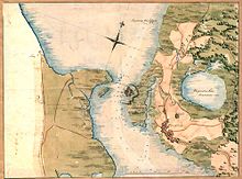
Peenemünde is the northernmost municipality on the island of Usedom and is located northwest of the seaside resort Karlshagen at the transition from the Peenestromes to the Baltic Sea .
Districts
- Peenemünde
- Desolations and living spaces
- Gaatz (desert)
- Jarchow (desert)
History of Peenemünde
Early history
Gold rings , which were discovered in the forest at Peenemünder Haken between 1905 and 1908 as a deposit, and another that was discovered in 1938 in the Peenestrom near Peenemünde as an excavation, document contacts to Scandinavia during the Viking Age . The rings are considered to be Danish goldsmiths from the time of Kings Gorm and Harald Blue Tooth in the 10th century.
Peenemünde was first mentioned in 1282 in a document by Duke Bogislaw IV , in which he donated the place to the city of Wolgast .
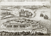
During the Thirty Years' War , the Swedish King Gustav II Adolf landed at Peenemünde with a 15,000-strong force on June 26, 1630 and soon occupied the entire Oder estuary after the conquest of Usedom. After the Peace of Westphalia in 1648, Peenemünde and Western Pomerania became Swedish.
During the Great Northern War , the Prussian general Georg Abraham von Arnim conquered the place from August 21 to 22, 1715. But only after the Peace of Stockholm in 1720 did the place with Usedom-Wollin and Old Western Pomerania become Prussian. Although a ski jump was built in front of Peenemünde on the Peenestrom as early as 1630 , the facility was only expanded as a real fortress in 1717. In 1759 this facility was modernized again because there were constant disputes between Prussia and Sweden.
After the administrative reform in 1815, Peenemünde became part of the Prussian province of Pomerania and from 1818 to 1945 belonged to the district of Usedom-Wollin .
In 1835 an amber mine was recorded in the PUM (Prussian Urmes Tischblatt) in Peenemünder Haken , which existed there as an open pit . Apparently this was not profitable or was exploited and was discontinued before 1880.
In 1858 Peenemünde had 550 inhabitants with the Gaatz Vorwerk, 33 families lived from fishing. There were 82 residential buildings and a school in the village. The village belonged to the city of Wolgast
In 1876 a chapel was built in the cemetery in Peenemünde.
After the storm floods of 1872, 1904 and 1913, which also badly destroyed Peenemünde, the construction of a dike with a height of 1.8 m began in 1927 .
From 1936: Army Research Institute

Peenemünde became known through the Peenemünde Army Research Center ( Peenemünde-Ost ) and the test site of the Air Force Peenemünde-West from 1936 to 1945. In 1936 the Wehrmacht acquired the entire north of the island from Karlshagen to Peenemünder Haken from the city of Wolgast and from private individuals. The population had to leave the place, only five residents remained as civil employees of the HVA (Heeresversuchsanstalt Peenemünde).
Since the high water of 1872 exceeded 2.64 m, that of 1904 with 1.90 m and that of 1913 with 1.91 m over the dyke of 1.80 m that had been built in the meantime, the dyke from Peenemünder Haken to the harbor was in 1939 Karlshagen increased to 4.0 m. Large quantities of sand were washed into the dike from the emerging harbor basin, the Peene River and the Baltic Sea, so that the level for the entire village area and the areas of the HVA could be increased by 2.0 m.
→ see main article Heeresversuchsanstalt Peenemünde and the test site of the Air Force Peenemünde-West
post war period
In accordance with the provisions of the Potsdam Agreement, the HVA facilities in and around Peenemünde were blown up after 1945, after all remains of the HVA had been secured and transported away by the Red Army . The area of Peenemünde after leaving Karlshagen was still a restricted area and could only be entered with separate passes to Peenemünde.
The HVA power plant was soon put back into operation to supply the military base and the population. It worked until 1990.
The site was used until 1952 as a Soviet naval and air base for the Red Army - later a group of the Soviet armed forces in Germany .
In 1952 the base was handed over to the Kasernierte Volkspolizei See as a forerunner of the National People's Army of the GDR. This took him, among other things as a naval base of the first flotilla of People's Navy and the airfield by the Jagdfliegergeschwader 9 of the air forces of the NVA . These military locations, the airfield and the military port, were further expanded; a repair yard was built north of the power plant for the NVA flotilla (now the north port). In the three control and testing facilities of the HVA in the south-east of Peenemünde, ammunition stores with the appropriate infrastructure were set up for the NVA.
Until 1990, the entire northern area of the island of Usedom up to Karlshagen was a restricted area of the National People's Army, which operated an important military airfield there . The Peenemünde airfield already belonged to the former test site of the Peenemünde-West Air Force and was expanded from 1958 to 1961.
After the reunification of Germany , the military base was dissolved in 1993.
The Nordic history of the island of Usedom was taken into account with the Viking camps at Pentecost from 1995 to 2000 in Peenemünde. A specially designed modern rune stone with rune signs later found its place in the harbor. The massive granite boulder bears an inscription carved into runes of the younger Futhark , which in translation contains the following: fusnan (= island of Usedom) - jomsbork (= Jomsburg) - CMXCV - MCMXCV (995–1995) . The Roman numerals refer to the 1000th anniversary of Mecklenburg-Western Pomerania, which was celebrated in 1995.
From 1945 to 1952, the municipality, with the part of the district of Usedom-Wollin that remained in Germany after the Second World War , formed the district of Usedom in the state of Mecklenburg , which was added to the Wolgast district in the Rostock district in 1952 . The community has belonged to the state of Mecklenburg-Western Pomerania since 1990 and from 1994 to the district of Ostvorpommern , which was added to the district of Vorpommern-Greifswald in 2011 .
Gaatz (desert)
Gaatz was mentioned in a document in 1693 as Holländerei Gartz . In the directory of 1906 it appears as Gaatz. The name is interpreted as a dike , but also as a wet field .
The village was located southeast of the Peenemünde location between Kämmerersee and the forest. Because of the location, only cattle farming was possible there, hence the old name Dutch .
It was marked as Vorwerk Gaatz on the measuring table sheet from 1920. With the construction of the HVA after 1936 it was dissolved and cleared away. In the course of the expansion of the HVA, a control stand was created there for the adjacent test stands or test and start systems for the A 4 (V2) units. In the direction of the Peenestrom, the Wehrmacht camp and the Peenebunker were built. All the objects mentioned around the Gaatz desert were connected with tracks from the HVA's works railway.
Jarchow (desert)
Jarchow was named as a district of Peenemünde in 1926. The location was not described. North of Peenemünde (old village) was the place designated only as Vorwerk Peenemünde in the MTB ( measuring table sheet ) 1880 and 1920.
Before 1936, the whole area including this place was bought up by the Reich, the inhabitants were resettled and the buildings were cleared as far as possible except for a few remains. The entire area was diked for the construction of the HVA and its sub-works and partially washed up by about two meters. Many areas, especially in the area of the current airport, were mossy meadows and breaks. There was also the place Jarchow, the former Vorwerk Peenemünde. The place was cleared and also washed up. However, there was no development for the HVA or branch plants. Today it is a wasteland southwest of the airfield.
politics
Municipal council
The seven-member community council consists of six community representatives and the mayor. In the local elections on May 25, 2014, the six community representatives were re-elected with a turnout of 61.6%. Four seats are allocated to the Peenemünde voter community (WP), one to the CDU and one to an individual applicant.
- Flat share : 5
- CDU : 1
- Otherwise: 1
coat of arms
|
Blasonierung : "Shared by a spickelförmig upward broken golden thread; at the top three (1: 2) golden crowns in red; a golden fish below in blue. "
The coat of arms was designed by Roland Bornschein from Wismar . It was approved on August 15, 1996 by the Ministry of the Interior and registered under the number 109 of the coat of arms of Mecklenburg-Western Pomerania. |
|
| Justification of the coat of arms: The three crowns in the coat of arms are intended to commemorate the landing of the Swedish fleet and the beginning of Swedish rule in Western Pomerania. The broken thread stands as a symbol for the mouth of the Peene in the Baltic Sea, the fish for the fishing industry as one of the traditional livelihoods of the inhabitants. |
flag
The municipality does not have an officially approved flag .
Official seal
The official seal shows the municipal coat of arms with the inscription "GEMEINDE PEENEMÜNDE".
Culture and sights
Missile Research Institute
- The entire Karlshagen - Peenemünde monument landscape (with the exception of the restricted areas due to ammunition residues) is signposted and provided with information boards.
- Chapel Peenemünde : In 1876 a chapel was built in the cemetery of the fishing village of Peenemünde. The octagonal central building of brick truss was built according to plans by Friedrich Kraeger . In addition to its function as a chapel , it now serves as a memorial for the victims of Peenemünde.
- A two-circuit 110 kV three-phase overhead line crosses the Peene between Peenemünde and Karlshagen, and its 75-meter-high masts are visible from afar. This line was built at the beginning of the 1950s to effectively carry the electricity generated in the Peenemünde thermal power station , which was largely no longer needed on Usedom after the Peenemünde Army Research Center was closed, to the mainland. A branch line to the Karlshagen substation was later built from this line. After the power plant was shut down in 1990, the 110 kV overhead line from the branch line to Karlshagen to the Peenemünde power plant was dismantled, so that the 110 kV three-phase current line over the Peene only feeds the Karlshagen substation.
- Karlshagen Memorial
Museums


- In the power plant and on the open spaces, the Historical-Technical Museum provides information about the history of the site and its surroundings in a comprehensive exhibition.
- Similar to Flensburg , Wolfsburg , Bremerhaven and Lüdenscheid , Peenemünde also has a Phenomenta , the “interactive exhibition to join in and try out”, which introduces the visitor to everyday phenomena in physics in a playful way.
- In the main harbor (Maritim Museum Peenemünde) lies the disused, diesel-powered submarine U-461 of the Baltic fleet (Red Banner fleet) with double launch containers for tactical missiles.
- A small privately operated toy museum is located in Peenemünde.
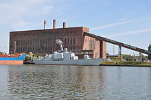
- The museum ship Hans Beimler is located in the main harbor , the former rocket high-speed boat of the Volksmarine can be visited.
Historical monuments
- Memorial chapel for Gustav Adolf v. Sweden near the open-air museum, destroyed in 1943, rebuilt in 1993 with an exhibition
- Memorial stone for the 300th anniversary of the landing of the Swedes under King Gustav II Adolf in 1930
- Foundling monument with bronze plaque as a stumbling block to commemorate the victims of forced labor in the army research facility
- Boulder memorial, in memory of the escape of Mikhail Petrovich Dewjatajew and nine other Soviet prisoners of war with a Heinkel He 111 bomber from the forced labor area
traffic
Passenger ferry
From the mainland, Peenemünde can be reached directly by ferry services from Kröslin and Freest.
Rail transport
Peenemünde can be reached via the Zinnowitz – Peenemünde railway with trains of the DB Regio Nordost , which uses the former works railway line (two-track in sections in 1943, later dismantled) of the Army Research Institute. In some places you can still see remains of the sidings and station tracks, some platforms (e.g. at the Trassenmoor stop and about 100 m north of the Karlshagen stop) and the concrete base of the electrical overhead line.
shipping
The community is the home port of the MS Adler Mönchgut , a passenger ship in the passenger shipping company Eagle ships , which in the summer on scheduled services between the islands of Rügen wrong and Usedom.
Airfield
The Peenemünde airfield is the starting point for island tours over Usedom. It is also used as a motorcycle racing track.
Personalities
- Kurt Ruchholz (1925–2008), geologist and university professor
See also
literature
- Volkhard Bode, Gerhard Kaiser: Missile tracks. Peenemünde 1936-2000. A historical report. Links-Verlag, Berlin (5th edition) 2004, ISBN 3-86153-345-6 .
- Johannes Erichsen and Bernhard M. Hoppe (eds.): Peenemünde. Myth and history of the rocket. Catalog of the Peenemünde Museum. Berlin 2004.
- Martin Kaule: Peenemünde. From the missile center to the monument landscape. Ch. Links Verlag, Berlin 2014, ISBN 978-3-86153-764-9 .
- Bernd Kuhlmann: Peenemünde - The missile center and its industrial railway. GVE-Verlag Berlin (3rd revised edition) 2012, ISBN 978-3-89218-100-2 .
- Thomas Stamm-Kuhlmann: Rocket armor and international security from 1942 to today (= historical messages on behalf of the Ranke Society, vol. 56). Wiesbaden 2004.
- Lutz Mohr : On Viking traces between Bodden and Peene. In: Heimathefte for Mecklenburg-Vorpommern. Series of publications: history, culture, nature and the environment. Vol. 2, No. 1, Schwerin 1992, pp. 26-32.
- Lutz Mohr: The memorial stone for the Swedish king Gustav II Adolf (1594–1632) in Peenemünde / Usedom island and the historical surroundings. In: Stone Cross Research (SKF). Studies on German and international land monument research. Edited by Rainer H. Schmeissner, Series B (anthologies), anthology no. 23 (NF 8), Regensburg 1996, pp. 90-101.
Web links
Individual evidence
- ↑ Statistisches Amt MV - population status of the districts, offices and municipalities 2019 (XLS file) (official population figures in the update of the 2011 census) ( help ).
- ^ Rodgero Prümers: Pommersches Urkundenbuch . Volume 2, Department 2, 1278–1286, Theodor von der Nahmer, Stettin 1885, pp. 475–476.
- ↑ Dirk Schleinert: The history of the island of Usedom. Hinstorff, Rostock 2005, ISBN 3-356-01081-6 , p. 73.
- ↑ a b Manfred Niemeyer: Ostvorpommern I . Collection of sources and literature on place names. Vol. 1: Usedom. (= Greifswald contributions to toponymy. Vol. 1), Ernst-Moritz-Arndt University of Greifswald, Institute for Slavic Studies, Greifswald 2001, ISBN 3-86006-149-6 . P. 13 ff.
- ↑ Office Usedom-Nord ( Memento of the original from September 4, 2014 in the Internet Archive ) Info: The archive link was inserted automatically and has not yet been checked. Please check the original and archive link according to the instructions and then remove this notice. (PDF; 7 kB)
- ↑ Hans-Heinz Schütt: On shield and flag production office TINUS, Schwerin 2011, ISBN 978-3-9814380-0-0 , p. 370.
- ↑ a b main statute § 1 (PDF).
- ↑ Maritim Museum Peenemünde ( Memento from January 23, 2013 in the Internet Archive ), Kulturportal MV
- ↑ http://www.usedom-spielzeugmuseum.de/ Spielzeugmuseum Usedom


