
Oldsum
| coat of arms | Germany map | |
|---|---|---|

|
Coordinates: 54 ° 44 ' N , 8 ° 27' E |
|
| Basic data | ||
| State : | Schleswig-Holstein | |
| Circle : | North Friesland | |
| Office : | Foehr-Amrum | |
| Height : | 4 m above sea level NHN | |
| Area : | 13.31 km 2 | |
| Residents: | 505 (Dec 31, 2019) | |
| Population density : | 38 inhabitants per km 2 | |
| Postal code : | 25938 | |
| Area code : | 04683 | |
| License plate : | NF | |
| Community key : | 01 0 54 098 | |
| Office administration address: | Hafenstrasse 23 25938 Wyk auf Föhr |
|
| Website : | ||
| Mayor : | Hark Riewerts | |
| Location of the municipality of Oldsum in the North Friesland district | ||
  |
||

Oldsum ( North Frisian : Olersem ) is a municipality in the district of North Friesland in Schleswig-Holstein .
geography
Oldsum is located in the northwest of the North Frisian island of Föhr .
The municipality of Oldsum consists of the three villages Oldsum (North Frisian: Olersem ), Klintum (North Frisian: Klantem ) and Toftum (North Frisian: Taftem ), which extend - roughly from west to east - for around two kilometers along the main road. The townscape is characterized by well-preserved, thatched-roof farmhouses. The landmark of Oldsum is an old, thatched-roof windmill, the predecessor of which dates from around 1700, burned down two hundred years later, was rebuilt until 1954 and has been used as a residential building since 1972. The distance to the west coast of the island is about two kilometers, to the north coast it is a little less. To the south of Oldsum is the municipality of Süderende , to the southwest of Dunsum and to the east of Alkersum and Midlum .
history

Oldsum was first mentioned in 1462 as Uluersum . In the 17th century the village was an important whaling place . One of the most successful whaling commanders, Matthias Petersen , born in 1632 , lived in Oldsum. He caught 373 whales in his lifetime. His grave is still today in the cemetery of the St. Laurentii Church in Süderende .
As part of Westerland Föhr , the three localities belonged to the royal enclaves and belonged directly to the Kingdom of Denmark, while Osterland Föhr and Wyk belonged to the Duchy of Schleswig . Only after Denmark lost Schleswig to Prussia , these places also came to Schleswig-Holstein in 1864. In the process, the Oldsum community lost the Süderende district south of the center , which has been an independent community since then. Since this split, Oldsum has had an uninhabited exclave south of Süderende with an area of around 122 hectares , which was not assigned to Süderende at the time.
Already on Friedrich von Warnstedt's map from 1823, Oldsum, Klintum and Toftum appear as a contiguous row village with no recognizable settlement boundaries between the places.
Before 1867, Klintum and Oldsum formed the municipality of Oldsum-Klintum, which merged with Toftum in 1970 to form the municipality of Oldsum. Until 1970 Oldsum-Klintum and Toftum were independent communities. In 1970 they merged to form what is now Oldsum.
politics
Of the nine seats in the municipal council, the Oldsum Voting Association (OWG) has eight seats since the local elections in 2018 . A single applicant holds another seat .
Economy and Transport
With the increase in tourism, especially in Oldsum, agriculture faded more and more into the background. Today there are only a few farms in the village. Some of them were also relocated from the village in the 1950s and 1960s and are outside of the village, but still in the municipality. Oldsum made a change from a farming village to an artists' village. There are numerous studios and galleries there. Other important economic factors are a growing number of craft businesses and retailers.
State road 214, the "Rundföhrstrasse", leads south of Oldsum . The towns of the Oldsum community are connected by county roads.
Attractions
The list of cultural monuments in Oldsum includes the cultural monuments entered in the list of monuments of Schleswig-Holstein.
Sons and daughters of the church
- Matthias Petersen (1632–1706), as Matthias the Lucky , famous whaler
- Hinrich Braren (1751–1826), captain and navigation teacher
- Oluf Braren (1787–1839), painter
- Nickels Peter Hinrichsen (* 1939), naval officer, 1982–1986 commander of the Gorch Fock
- Friede Springer (* 1942), majority owner of Axel Springer AG
Picture gallery

Frisian house with typical stone wall
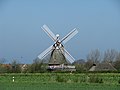
The Oldsum windmill is a landmark of the place
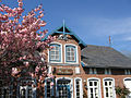
Friede Springer's birthplace


Web links
Individual evidence
- ↑ North Statistics Office - Population of the municipalities in Schleswig-Holstein 4th quarter 2019 (XLSX file) (update based on the 2011 census) ( help on this ).
- ↑ Schleswig-Holstein topography. Vol. 7: Munkbrarup - Pohnsdorf . 1st edition Flying-Kiwi-Verl. Junge, Flensburg 2006, ISBN 978-3-926055-88-0 , p. 266 ( dnb.de [accessed on July 22, 2020]).
- ^ Brar C. Roeloffs: From seafaring to agriculture. A contribution to the history of the island of Föhr. Karl Wachholtz Verlag, Neumünster 1984, ISBN 3-529-06184-0 , p. 16 .
- ^ Föhr-Land: communities of voters in front. In: Der Insel-Bote from May 7, 2018, accessed on May 9, 2018
Achtrup | Ahrenshöft | Ahrenviöl | Ahrenviölfeld | Alkersum | Almdorf | Arlewatt | Aventoft | Bargum | Behrendorf | Bohmstedt | Bondelum | Bordelum | Borgsum | Bosbull | Braderup | Bramstedtlund | Bredstedt | Breklum | Dagebüll | Drage | Drelsdorf | Dunsum | Elisabeth-Sophien-Koog | Ellhöft | Emmelsbüll-Horsbüll | Narrow Sands | Fresendelf | Friedrich-Wilhelm-Lübke-Koog | Friedrichstadt | Galmsbüll | Garding | Garding, parish | Goldebek | Goldelund | Gröde | Grothusenkoog | Haselund | Hattstedt | Hattstedtermarsch | Högel | Spar | Hooge | Hörnum (Sylt) | Horstedt | Hude | Humptrup | Husum | Immenstedt | Joldelund | Kampen (Sylt) | Karlum | Katharinenheerd | Klanxbüll | Klixbull | Koldenbüttel | Kolkerheide | Kotzenbüll | Ladelund | Langeneß | Langenhorn | Leak | Lexgaard | List on Sylt | Löwenstedt | Lütjenholm | Midlum | Mildstedt | Fog | Neukirchen | Nieblum | Niebüll | Norddorf on Amrum | Norderfriedrichskoog | North beach | Norstedt | Ockholm | Oevenum | Oldenswort | Oldersbek | Olderup | Oldsum | Ostenfeld (Husum) | Oster-Ohrstedt | Osterhever | Pellworm | Poppenbüll | Ramstedt | Rantrum | Reußenköge | Risum-Lindholm | Rodenäs | Sankt Peter-Ording | Schwabstedt | Schwesing | Seeth | Simonsberg | Sollwitt | Sönnebüll | Sprakebull | Stadum | Stedesand | Struckum | South end | Süderhöft | Süderlügum | South March | Sylt | Tating | Tetenbull | Tinningstedt | Tönning | Tümlauer-Koog | Uelvesbüll | Uphusum | Utersum | Viöl | Vollerwiek | Vollstedt | World | Wenningstedt-Braderup (Sylt) | Wester-Ohrstedt | Westerhever | Westre | Winnert | Wipe | Witsum | Wittbek | Wittdün on Amrum | Joke word | Wobbenbüll | Wrixum | Wyk on Föhr