Ungerberg (Saxony)
| Ungerberg | ||
|---|---|---|
|
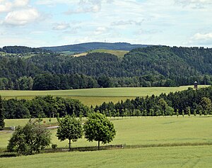
View from the Rathmannsdorfer observation tower to the Ungerberg with the distinctive cell phone tower |
||
| height | 537.2 m above sea level NHN | |
| location | Free State of Saxony , Germany | |
| Mountains | Lusatian highlands / Saxon Switzerland | |
| Coordinates | 50 ° 59 '49 " N , 14 ° 13' 47" E | |
|
|
||
| rock | Granodiorite | |
| particularities | Prince Georg Tower ( AT ) | |
The Ungerberg is a mountain located south of Neustadt in Saxony and belonging to the urban area. With a height of 537.2 m above sea level. NHN , it is a popular excursion destination in the region. Hiking trails lead up the mountain from six directions. The summit can also be reached via an access road.
Restaurant and lookout tower
The mountain, which at that time was still largely unforested, was already a popular vantage point when the Elbe Sandstone Mountains were opened up for tourism and which was praised by Wilhelm Leberecht Götzinger . When growing trees increasingly blocked the view, the manor owner von Burkersdorf had a covered wooden observation tower built in 1846. A small tavern opened at the foot of the tower. But in December 1848 the tower was destroyed by arson.
Today's stone tower, known as the Prinz-Georg- Tower, was built in 1885 with a height of 18 m. Julius Missbach from Neustadt in Saxony (born September 8, 1831 in Gelenau near Kamenz , † December 8, 1896 in Neustadt in Saxony) made a decisive contribution in 1883 to laying the foundation stone of the stone tower and building the restaurant . In 1973 a renovation took place in which the tower was raised. Today its height is about 33 m. There is also a mountain hotel with a restaurant on the hill, which was built on the foundations of the 1885 inn that burned down in 1929. The area with the observation tower and the restaurant was acquired by a foundation company, which reopened both the tower and the inn in the summer of 2018. There is also a small animal enclosure .
Telecommunications tower
On the Ungerberg there is also a 74.9 meter high telecommunications tower ( type tower FMT 9) built after German reunification , which is also used to distribute VHF radio programs. The programs are broadcast in analogue and in the digital DAB + standard as follows:
Analog radio (FM)
|
Frequency (MHz) |
program | RDS PS | RDS PI | Regionalization |
ERP (kW) |
Antenna pattern round (ND) / directional (D) |
Polarization horizontal (H) / vertical (V) |
|---|---|---|---|---|---|---|---|
| 89.6 | MDR current | MDR _____ / CURRENT_ | D3D5 | - | 0.2 | D (80 ° -200 °) | H |
Digital radio ( DAB + )
DAB is broadcast in vertical polarization and in single-frequency mode with other transmitters.
view
From the tower you have a beautiful panoramic view of the surrounding landscape and the mountains. In the south and west you can see the typical rock plateaus of the Elbe Sandstone Mountains , striking the Lilienstein , Königstein and Großer Winterberg . Behind it you can see the Eastern Ore Mountains when the visibility is good . In the east you can see the Lusatian Uplands and Zittau Mountains and with good visibility the Jizera Mountains and the Giant Mountains . In the north is the Hohwald with the Valtenberg as the highest elevation.
In winter, the descent towards Krumhermsdorf is popular as a toboggan run. There is a ski lift in Rugiswalde .
Web links
Individual evidence
- ↑ a b Map services of the Federal Agency for Nature Conservation ( information )
- ^ Wilhelm Lebrecht Götzinger: Schandau and its surroundings or description of the so-called Saxon Switzerland . GG Monse, 1804, p. 374 ( Google Books ): “You have to take a guide with you who takes you to the Unger. The very high mountain, which is one of the most famous in this area because of the splendid views it gives. "
- ^ Annette Schneider, Rolf Wilhelm Brednich, German Society for Folklore, Ute Werner, Rolf Wilhelm Brednich: Nature - Culture: Folklore perspectives on people and the environment . Waxmann Verlag, 2011, ISBN 978-3-8309-6100-0 ( Google Books ).
- ↑ Julius Missbach. Retrieved February 17, 2019 .


