
All
.png)
_IMG_2472.jpg)
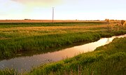
The Aller (Al) is a 260 km long, south-eastern and right tributary of the Weser in Saxony-Anhalt and Lower Saxony (Germany).
At the confluence of the Aller into the Weser near Verden , with an average water flow of 120 m³ / s, it is not only its largest tributary, but also the largest river in northern Germany that does not flow into the sea. Its lower part, the 115.8 km long (flowing stretch) Unteraller , is designated as a federal waterway . During the Allerregulierung in the 1960s, the river was largely expanded and straightened in some places, and largely for flood protection dikes .
Name interpretation
There are two possibilities for the explanation of the river names handed down as Alera in 781 , Elera in 803 , and Alara in 1096 :
- Interpretation as a shortening of * Eleraha , where * Eler can be traced back to Old Germanic * olisa or Old Slavic olsa (Polish: olsza ) for alder and aha (read: "Acha") corresponds to an old word for water that is common in river names (cf. Latin aqua ). The tree name has been adopted from Low German as Eller , which comes very close to the word Aller . All would therefore mean something like “Alder Water”, which could be derived from the fact that the river was largely overgrown with alder , a type of tree that prefers to grow in wet locations.
- In Hans Krahe's system of old European hydronymy , the old name of the Aller as Alara is an example of a series of river names with the root al- , which are spread over a large part of Europe and, according to Krahe, all refer to an Indo-European root * el - / * ol- with the meaning of flow back. For example, Alle , Alster , Iller , Elz or Ilmenau would be closely related . Krahe's hypothesis is, however, controversial in linguistics. Theo Vennemann adopted Krahe's model in a modified form in the theory of Vasconic language .
course
Above all


The Aller rises in Saxony-Anhalt in the west of the Magdeburg Börde between Oschersleben and Helmstedt . Their source streams gather on the northeast side of the Hohe Holz near Seehausen .
First, the Aller flows as a canal-like brook through hilly, intensively cultivated farmland in a north-westerly direction. The Flechtinger mountain range extends to the east and the Lappwald with its foothills to the west . The river passes the places Eilsleben and Weferlingen . After about 60 kilometers of the river, it reaches the southern edge of the Drömling near Oebisfelde and thus the glacial valley , which it follows to the mouth. On the other side of the state border with Lower Saxony, the Aller bends west at Grafhorst . Here the terrain level is 55 m . Until about 150 km from the mouth of the Aller loses just 40 meters in height, so it off here more slowly through a wide now as grassland used Aue flows. From Wolfsburg it has a generally west-northwest direction.
In Wolfsburg, the Aller at Wendschott crosses the Mittelland Canal in a culvert , crosses the Allerpark and passes the Allersee .

Everyone at Wefensleben
All at Oebisfelde
Allerbrücke in Vorsfelde


South of Weyhausen , the Allerkanal, which was built between 1860 and 1863 and is around 15 km long, branches off from the Aller . It should divert the long-lasting floods that were feared at the time more quickly. The canal runs to the return line west of Gifhorn a few kilometers south of the Aller through the Barnbruch and past Gifhorn, while the Aller flows through the city. In this almost 30 km long section parallel to the Allerkanal, the river can still meander in its natural river bed. East of Gifhorn near Osloß , the Aller is crossed by the Elbe Lateral Canal in a trough bridge. West of the city, the Oker, which is a little richer in water, is the first major tributary to flow into Müden .
Middle of all
Between the Oker estuary and Celle , the Aller is known as the Mittelaller in a 30 km long section. A little above Celle it flows past Wienhausen and his monastery . In Celle it is dammed for energy generation and crosses here with its side arms, the Magnusgraben and the Stadtgraben, the French Garden , the old town and the castle .

Beginning of the Mittelaller at the confluence of the Oker (right) in the Aller bei Müden

The Allerwehr in Celle with the Bundesstrasse bridge. 3


Under all
The last, 112.1 km long (shipping route, shortened by lock canals) section below Celle is navigable ( federal waterway ). Larger places are initially Winsen , above which the Örtze flows from the right , and Wietze . At Eickeloh , a yaw ferry crosses the Aller. There the Leine flows from the left , like the Oker, a little richer in water than the Aller, but with a smaller catchment area and no longer than the flow path from the Oker spring to the Lein estuary. Then the river Ahlden passes . From Eilte (part of Ahlden) to Hülsen it has several distinct meanders; The fact that the curves are not as narrow here as above the Oker estuary is not an expression of straightening, but a physical consequence of the much larger flow rate . The meanders form two groups. In the first group from Eilte to Frankenfeld , the most impressive is the loop, into whose bulging slope the Böhme flows from the right , the loop encloses a one and a half kilometer long headland on the left bank but only 160 m wide at the narrowest point with the village of Bosse . The small town of Rethem follows on the left bank . The Allerschleifen between Wohlendorf and Hülsen have been a nature reserve since 2004. Finally , the Aller flows into the Weser around 4 kilometers northwest of Verden , near the Eissel district. Before that there is an Alte Aller as a former left parallel run across from Verden, then another Alte Aller to the right of the Langwedeler Schleusenkanal to the former Allerm estuary further downstream.

The mouth of the Örtze (left) into the Unteraller near Winsen (Aller)

All-loop bosses, feeding arch, view from the isthmus towards the head

... and a leading curve, view from the isthmus downstream


Aller-glacial valley

_20150701.jpg)
Above Wolfsburg, the Aller enters the Ice Age drainage channel of the Aller- Urstromtal as part of the Breslau-Magdeburg-Bremer Urstromtal . The valley, which is an average of 20 km wide, was formed during the penultimate Ice Age, the Saale Ice Age around 200,000 years ago. Meltwater flowed into the North Sea in it. Today's floodplain is only slightly sunk into the kilometer-wide glacial valley with its many formerly intertwined flow channels. Within this floodplain, the meanders used to change with every flood. Today there are numerous dry lying backwaters , Totarme and remaining arms in the floodplain (z. B. the old Aller ). In the last glacial period, the Vistula glacial period, a broad fringe of inland dunes parallel to the river was blown north of the floodplain .
The floodplain of the Allerniederung between Celle and Verden is mainly used as grassland today. The humid, groundwater-related lowlands of the Aller and the confluent tributaries with their oxbow lakes, pools , groups of trees and rows of bushes have a species-rich flora and fauna . Due to gravel due to the post-glacial sea rise and the damming dune wall, fractures and bogs formed off the rivers . In the lower area, arable farming is also practiced on clay soils. In the upper reaches, pine forests are often cultivated on sandy soils.
There are preserved meanders on river km 181 to 151 near Gifhorn (Fließweg 30 km, straight line with bend 18.45 km, without bend 17.65 km, ratio 1.7: 1) and on river km 49.5 to 23 , 5 in front of and behind Rethem (Fließweg 26 km, linear distance 12 km, ratio 2.2: 1).
Tributaries
The largest tributaries
The Aller has three tributaries over 100 km in length, all three from the left. In the case of Müden (Aller) this is the Oker , in Celle the Fuhse and in Schwarmstedt the Leine .
- The Oker is longer and richer in water than the Aller above its mouth, so hydrologically the actual upper reaches of the Aller.
- The foot only brings water from the Harz foreland , not from the Harz itself.
- With a length of 280 km, the Leine is the third longest river in the Weser river system , viewed hydrologically after the Werra-Weser (751 km) and Oker-Aller (460 km) rivers, specifically after the Weser itself and the Werra (299.6 km) ). Its catchment area of 6,517 km² is larger than that of the Werra (5,497 km²).
The other tributaries mainly drain parts of the Lüneburg Heath .
Tributaries above the Oker
Downstream sequence, tributaries of the Allerkanal are lined up according to how they emptied in front of it:
- left: Salzbach from Morsleben
- right: Bartensleben main ditch
- left: Brunnentalbach from Bad Helmstedt
- left: Riole from the Lappwald
- left: Graslebener Mühlengraben
- right: Schölecke
- right: wages
- right: Spetze
- left: Lapau
- Right : Middle Drömling sgraben
- left: Katharinenbach
- right: Vorderer Drömlingsgraben
- left: Steekgraben with Hehlinger Bach
- right: Wipperaller
- left: Hasselbach
- right: Little Aller
- left into the Allerkanal: Kronriede
- right: Beverbach
- right: Springriede
- right: Maschgartenbach
- left: Clausmoorgraben
- right: Triangle Bog Canal
- right: Platendorfer Moorgraben
- left into the Allerkanal: Mühlenriede (old lower reaches to the Aller: Barnbruchsgraben )
- right: Ise
- left into the Allerkanal: Hehlenriede
- left through the Alte Hehlenriede into the Allerkanal: Vollbütteler Riede and Rötgesbütteler Riede
- left into the Allerkanal: Viehmoorgraben
Tributaries between the Oker and Leine
- re. before Wienhausen the Schwarzwasser
- re. between Lachtehausen and Celle die Lachte
- left in Celle die Fuhse
- left into the Fuhsekanal the Burgdorfer Aue
- re. at Winsen (Aller) die Örtze
- left in Wietze the Wietze
Tributaries below the Leine
- re. at Hodenhagen the Meiße
- re. in Böhme the Böhme
- left in Rethem the Alpe , whose main mouth through a flood into that of the
- Wölpe was relocated
- left in Rethem-Wüllendorf the Schipsegraben
- re. before Kirchlinteln -Hohenaverbergen the Lehrde ,
- re. in Verden- Eitze the Gohbach
- left in Verden die Wätern (from Wahnebergen as Alte Aller)
- re. 2 km before the Allermund at Verden-Dauelsen the Halsebach .
Palaces, castles, monasteries

- Bunkenburg , as a ring wall system of the 13th century on the Aller in Ahlden (Aller)
- Bierde Castle near Bierde
- Blankenburg Castle near Essel
- Blankenhagen Castle near Grethem
- Hodenhagen Castle near Hodenhagen
- Castle Hudemühlen in the Hodenhagen district of Hudemühlen, built as a castle in the 14th century, converted into a Renaissance castle in the 16th century and demolished in the 19th century
- Burg Oebisfelde than lowland castle probably in the 10th century on a sandbank of the Aller in the marshes of Drömling built
- Rethem Castle in Rethem (Aller), built in the 13th century and expanded into a bastion in the 17th century
- Verden Cathedral , built in the 12th century
- Wienhausen Monastery , formerly a Cistercian monastery from the 13th century
- Castle Bartensleben as Wasserburg emerged
- Ahlden Castle , built in 1549 as a moated castle on the Aller, in whose river bed the Leine flowed from 1618
- Celle Castle , built in the 10th century as a defense tower on an Allerfurt
- Gifhorn Castle , completed in 1581 with the character of a fortress
- Uhlenburg near Essel , as a noble residence of the 14th century
- Wolfsburg Castle , as a residential tower in. 14th century on the Aller developed into a moated castle with the character of a fortress
Culture and tourism
The Aller is one of the few - at least apparently - untouched larger rivers in Germany. From Celle to the Verden area, it forms the scenic Aller-Leine valley with the Leine . The Aller flows leisurely in a relatively natural environment along meadows and forests and through smaller villages and rural towns. It is therefore of great importance as a recreational area for the almost 4 million people in the Hanover-Braunschweig-Göttingen-Wolfsburg metropolitan region . Efforts are being made to expand tourism along the river in a nature-friendly way through gentle tourism , especially in the Aller-Leine valley. The approximately 250 km long Aller Cycle Path usually accompanies the river at a greater distance. Other leisure activities are river trips by canoe or houseboat . Water skiing is permitted for a limited time in smaller sections in the lower reaches of Hornbostel and Frankenfeld.
Hydrology
The river is the most water-rich tributary of the Weser. The catchment area of the Aller covers about a third of that of the Weser with 15,744 km²; of the catchment area above the Allermouth it is even 41.45%, more than Werra and Fulda combined and more than the Weser from Hann. Münden to Verden with one of its two source rivers. The Rethem gauge below the confluence of the Leine registers an average water flow of 114 m³ per second. At the confluence with the Weser, the Aller carries 120 m³.
From a hydrological point of view, the actual upper reaches of the Aller is the Oker , in terms of length, catchment areas and flow rates up to the confluence. Via this river and the Leine, the Aller absorbs about half of the amount of water flowing out of the Harz Mountains (the other half goes via the Saale and its tributaries into the Elbe). Accordingly, it is often exposed to flooding, especially from these tributaries.
Flow rate
The flow speed of the Aller is slow in places. In the upper reaches at the height of the Drömling, the body of water resembles a sluggishly flowing canal, in parts a body of still water . Apart from the reservoirs, the mean flow velocity is due to the low gradient, which in Lower Saxony is only 10–20 cm per kilometer (0.1 to 0.2 ‰) on average. The current is evenly sluggish in the upper reaches. Here the bottom of the water is covered by a mixture of sand and mud.
Sewage discharges
In the upper reaches of the Aller from the source to Müden / Aller, the treated wastewater from around half a million people is discharged directly and via tributaries . There are 40 larger sewage treatment plants for cleaning . The wastewater from the city of Wolfsburg, the only major city on the river, is not discharged, but trickled into sewage fields . The Volkswagen plant in Wolfsburg also uses the river water and discharges wastewater after cleaning in its own sewage treatment plant . The chemical water status of the Aller shows that the wastewater discharged is mostly treated satisfactorily.
Heavy metal pollution
The pollution of the Aller with heavy metals results from centuries of mining in Upper Harz . As a result, the Harz rivers, such as the Aller tributary Oker , absorb heavy metals from spoil heaps. It is mainly cadmium, zinc and lead compounds that accumulate in the suspended matter in the river. The solids are transported by the Oker all the way to the Aller and Weser, where they settle as sediments in calm water zones. In 1999, studies were carried out on the heavy metal content in suspended matter in the Aller near Verden. They showed that the Aller loads the Weser disproportionately with lead, cadmium, zinc and mercury.
Water quality
The Lower Saxony water quality report from 2004 rated the chemical water pollution of the Aller as moderately polluted (quality class II ). For individual indicators it is in quality class I ( unloaded to very lightly polluted ), but in some cases also very heavily polluted (quality class III-IV ). Heavy pollution primarily affects nitrate pollution . The local pollution with ammonium is attributed to the insufficient effectiveness of some sewage treatment plants. Increased phosphate levels were found in the intensively arable area near the source. The salinity today is below the critical limit for damage to aquatic plants . The salt content has decreased considerably since 1990, which may be related to lower discharges from the former GDR area as a result of the fall of 1989. The biological water quality based on the investigation of the saprobic system has mostly the condition unpolluted to very low . Only the area around Wolfsburg is critically polluted, for which digested sludge deposits in the river are responsible.
There is hardly any shade protection through forests (except along the Allerkanal in the Gifhorn district), so that direct sunlight promotes the spread of aquatic plants. The river water also warms up considerably in the summer without shady trees.
Floods and historical flood protection


In the past, spring floods often occurred in the lowlands, and they lasted for a long time. This was mainly due to the small river gradient from the entry into the Ice Age drainage channel of the Breslau-Magdeburg-Bremen glacial valley . After the snow melted, the river had to absorb large amounts of water in the Leinebergland and Harz through the Leine and Oker . In the spring, the Aller in the upper reaches filled the shallow Drömling swamp basin , from which the water withdrew slowly. In addition, the ear flowed diffusely through the Drömling. Since the watershed between the Weser and Elbe runs through the Drömling as a valley watershed , the direction of flow could even change, with the water from the Aller flowing to the Elbe. The eastern part of the Drömling, which belongs to Prussia , was drained by Prussian King Frederick the Great between 1780 and 1796 and made arable for colonists . The 24 km long Allerkanal was built from the vicinity of Grafhorst into the Calvörde area , through which all water could flow to the Ohre. Another canal for flood protection was the watercourse, also called the Allerkanal , which was completed in 1863 and protected the Allern lowlands near Gifhorn from flooding. The construction of the Mittelland Canal in the 1930s enabled excess water from the Aller to be drained away. This has been done at Grafhorst since 1952 through Aller-Relief II, a 3 km long canal. Despite these measures, floods also occurred in the Aller valley in the 20th century, which led to losses in agriculture.
Today's flood protection
In the years 1954 to 1962 there were repeated floods on the Aller ; In particular, the July floods in 1956 and the June floods in 1961 caused considerable damage in the floodplains. This was due to the uneven flow behavior of the river with flood plains between 300 m and 5,000 m wide in the Aller valley. In 1961, the Lower Saxony State Parliament decided, as part of the Aller-Leine-Oker Plan, to regulate floods by expanding the Aller and its tributaries. It served to protect the settlements and agriculture, which suffered heavy losses, especially due to the floods in 1956 and 1961.
As a result of the Aller-Leine-Oker Plan, Aller regulation took place in the 1960s, as a result of which numerous flood retention basins and dams were built on both the Aller and the Leine and their tributaries. In the 1970s a 15 hectare flood retention basin was built near Gifhorn. In contrast, a planned retention basin at the Allerknie near Grafhorst was tested for environmental compatibility between 1993 and 1996 . The planned 12.5 km² Fahle Heide basin west of Gifhorn was not built for lack of financial resources. The extension of the Aller included redesigning the bank over long stretches. For this purpose, the state acquired bank areas up to 12 m wide from the rivers. The banks were flattened and filled with stone. Willows, alders and reeds were also planted to protect the banks. In the area of the Oberaller the river was designed 15 m wide, in the area of the Mittelaller 30 m wide and on the Unteraller 50 m wide from the mouth of the Lein. Flood dikes were built on the Unteraller near Rethem (Aller) , Westen and Häuslingen .
Around 2010 the all flood relief I between Grafhorst and Rüßen , which also drains into the Mittelland Canal, was expanded as part of a larger project, with which the groundwater level in the Drömling is also regulated in the sense of even watering.
Flood protection in the Celle region

As early as the 1980s, the city of Celle prepared a framework for flood protection in the Celle region . Here a combination of many measures such as foreland excavations and the construction of flood channels and dykes is described. On June 6, 2005, the city received approval to start the first phase of the flood protection projects. Work began in 2006. This first phase of construction between the Boye and the Fuhse estuary (cost: around two million euros) is all about so-called foreland excavations, which are intended to increase the runoff profile of the Aller during floods. The flood basins have a size of about 15 hectares. Around 240,000 m³ of soil was washed away 1½ meters deep. Just two years later it was found that this was causing sand to be deposited in the river and creating shallows, so that the fairway in the area of the new flood troughs had to be dredged for the first time in May 2009. It is now planned to redesign and partially dismantle the flood basins in order to reduce sand deposits in the future.
Passability for fish
.JPG)
When the Aller was expanded in the 1960s, the gradient increased due to the shortened run. In this Sohlabstürze installed later for better passability by aquatic organisms in Sohlgleiten were converted. The weir at Grafhorst , with which water is dammed up in summer to raise the groundwater level, is no longer a fish obstacle thanks to a fish ladder . At the end of 2009 a new large fish migration aid was completed at Bannetze ( Winsen ). In Celle there is a fish pass 150 m long and 2.30 m wide and a fish pass around 20 m long, which were completed in August 2012. The migration of fish from the North Sea is still prevented by several weirs. There are obstacles at Gifhorn and Müden (Aller) . The culvert of the Mittelland Canal near Wendschott is also insurmountable . The Aller, on the other hand, crosses freely under the Elbe Lateral Canal near Osloß .
natural reserve
In order to set up the Europe-wide Natura 2000 network of protected areas , the Aller is proposed by the state of Lower Saxony as a fauna-flora-habitat (FFH) area in accordance with Directive 92/43 / EEC and by the EU in 2004 for the Aller section from Wolfsburg to the confluence with the Weser recognized as such under number DE 3021-301.
According to Section 32 (2) of the Federal Nature Conservation Act , the FFH areas are to be declared protected parts of nature and landscape. According to Article 4 Paragraph 4 of the Habitats Directive, this should have been completed within 6 years, i.e. by the end of 2010, but has so far only been done very incompletely.
In the river sections between Wolfsburg and the Elbe Lateral Canal and between Thören and Otersen, the Aller lies in the EU bird protection areas "Barnbruch" and "Untere Allerniederung" in accordance with the EU bird protection directive. The declaration of the most suitable areas (meaning the EU bird protection areas) required in Article 4 of this directive as protected areas within the meaning of the Federal Nature Conservation Act is now even more behind after 35 years (2014) than that of the FFH areas.
shipping
history
middle Ages
In the High Middle Ages , the Aller was not only driven to Celle , but also with the small vehicles customary at the time to the Oker and this up to Braunschweig . This is attested by a passage in the city law of the Braunschweig district of Hagen from 1227.
The river shipping contributed to the economic rise of Braunschweig, since Duke Heinrich the Lion managed to get it into his hands. The transport route for metals from the Harz Mountains from Braunschweig to the North Sea first ran over the Oker and then the Aller and Weser. In the 14th century, Celle was the most important grain loading point ( grain ) in what is now Lower Saxony. By 1500 the all ships could already carry a load of around 60 t . Above all, the Unteraller between Celle and Verden was of great economic importance for shipping in earlier centuries.
However, shipping traffic in the upper sections of the river could not be maintained for centuries, but required contractual security and technical water maintenance. After the first bloom in the 13th century, it fell asleep in the middle of the 14th century, but started up again for about 150 years from the end of the century.
20th century and present
In 1907 the state of Prussia decided to extend the Aller from Celle to the mouth of the Lein at Schwarmstedt to around 50 km with barrages. In the years 1908 to 1918 the river was regulated by four barrages in Oldau , Bannetze , Hademstorf and Marklendorf with locks and thus navigable for larger barges. The transport was carried out by the Celler Schleppschiffahrts-Gesellschaft GmbH in Celle, which was founded in 1898. From Wietze, crude oil from the Vacuum Oil Company was first transported via Aller and Weser to the refinery in Nordenham, and from 1911 to Oslebshausen (now part of Bremen). Grain was also shipped to Celle for grinding. At the beginning of the 20th century, large quantities of potash salt were shipped on the Aller, which was exploited near Celle. The transport of coal from the Ruhr area to Oldau and Celle was also important. The maximum amount of goods transported was reached in 1912 with 125,000 t. Today there is no longer any commercial shipping.
Todays situation
Today the Unteraller is from its confluence with the Weser (at km 326.40) to Celle on 112.1 km of navigable federal waterways. The Verden Waterways and Shipping Office is responsible for its administration . The district of Oldau is responsible for the Aller from Celle (km 0.25) to Hülsen (km 94.1), and for the area from Hülsen to the confluence with the Weser near Verden-Eissel (km 117.16) the suburb of Verden.
Since the mid-1960s, only passenger and pleasure boat trips have taken place above Verden on the last kilometers of the river.
Ship sizes
- Estuary – Verden: waterway class III (length × width: 67 m × 9.50 m)
- Verden – Celle: waterway class II (length × width: 58 m × 9.50 m)
- Above Celle: no longer navigable
Locks
_Schleuse_Oldau_2008_by-RaBoe_05.jpg)

| place | location | Usable length | Usable width | Height of fall | Construction year |
|---|---|---|---|---|---|
| Oldau | km 14.7 | 159 m | 10 m | 3.21 m | 1908-10 |
| Ban nets | km 26.7 | 159 m | 10 m | 2.40 m | 1909-12 |
| Marklendorf | km 38.3 | 159 m | 10 m | 3.22 m | 1914 |
| Hademstorf | km 49.8 | 159 m | 10 m | 1.23 m | 1914-18 |
rafting
Rafting was probably practiced on the Aller as early as the 14th century. The wood transported was used as construction timber and firewood. The royal residence town of Celle was an early center of rafting and timber trading. Initially, the nobility obtained firewood to heat the Celle Castle and other princely buildings. The wood was felled in stately forests. Transport by raft was about ten times more effective than by horse and cart.
A larger rafting operation on the Aller took place in 1680, when a large amount of timber was rafted to the Weser up to the mouth of the Weser. The wood came from the southern Lüneburg Heath and was used to build around 100 houses in the Swedish fortress Carlsburg at the current location in Bremerhaven .
From the 17th century, wood was also floated on tributaries of the Aller to Celle, such as the Ise and Örtze . In Celle the wood was brought ashore at a needle weir and stored in a lumber yard. Rafts also went past Celle to the Weser in Bremen. After the death of Duke Georg Wilhelm in 1705, when the court was moved to Hanover, the timber rafting company returned to Celle. After that, raft traders took over the business. On the Unteraller, rafting flourished again at the end of the 19th century during the founding years . There was a great demand for wood in Bremen , Bremerhaven and in the Wesermarschen , where wood was used for building and shipbuilding . In the years around 1895, around 8,000 cubic meters went annually towards the Weser. After the First World War , rafting on the Aller came to a standstill.
Hydropower
_Wasserkraftwerk_Oldau_2008_by-RaBoe_02.jpg)
During the expansion of the Aller between Celle and the mouth of the Lein near Schwarmstedt from 1908 to 1918, hydropower plants were set up at two of the four new barrages (in Oldau and in Marklendorf ) . They served to electrify the Südheide . The Oldau power plant with three Francis turbines was commissioned in 1911 and was acquired by PreussenElektra in 1929 . In 1972 the power plants were shut down because they were unprofitable. While the buildings in Marklendorf were being torn down, the power plant in Oldau was declared a technical monument in 1974 . After modernization, it was reactivated in 1983, but has largely been preserved in its original state. The generator generates 6,000 volts three-phase current , the total rated power is 650 kW. The Oldau hydropower plant supplies 2.5 million kWh of electricity to the grid every year .
literature
- Jürgen Delfs: The rafting on Ise, Aller and Örtze (= series of publications from the Gifhorn district archive . No. 9 ). Gifhorn 1995, ISBN 3-929632-24-1 , p. 61 .
- Martin Eckoldt (Hrsg.): Rivers and canals: the history of the German waterways . in cooperation with the German Maritime Museum (DSM), Bremerhaven. DSV-Verlag, Hamburg 1998, ISBN 3-88412-243-6 , p. 526 .
- Wilhelm Kersting: The compensatory measures of environmental protection in the flood regulation of the Aller . Celle 1979.
- Stephan A. Lütgert: "For us the Aller-Correctur is a question of life ..." The short history of the Celler Schleppschiffahrt (= Industrial Culture Network . No. 6 ). 2017, ISSN 2199-3327 , p. 19-32 .
Web links
- Landscape profiles of the Federal Agency for Nature Conservation , on bfn.de
- Verden Waterways and Shipping Office: Die Aller - A shipping route
References and comments
- ↑ a b c Die Aller - Ein Schifffahrtsweg , Wasserstraßen- und Schifffahrtsamt Verden of the Federal Waterways and Shipping Administration, accessed on February 23, 2017, at wsa-verden.wsv.de
- ↑ Lower Saxony Ministry for the Environment, Energy and Climate Protection: Environment Maps Lower Saxony , accessed on March 18, 2015
- ^ Deutsches Gewässerkundliches Jahrbuch Weser-Ems 2014. Lower Saxony State Agency for Water Management, Coastal and Nature Conservation, p. 175, accessed on October 4, 2017 (PDF, German, 8805 kB).
- ↑ a b c level value Rethem plus area runoff of the remaining catchment area below (5.4 l / s km² to 993 km²), determined for the intermediate catchment area of the limiting gauges Rethem (Aller), Frankenfelderbruch (Alpe), Anderten (Wölpe), Lehringen (Lehrde) , Weitzmühlen (Gohbach), Dörverden (Weser) and Intschede (Weser). The resulting value of 120.4 m³ / s is rounded down.
- ↑ Note: in front of Saale (115 m³ / s), Havel (108 m³ / s) and Mulde (73 m³ / s)
- ↑ a b c Lengths (in km) of the main shipping routes (main routes and certain secondary routes) of the federal inland waterways ( Memento from January 21, 2016 in the Internet Archive ), Federal Waterways and Shipping Administration, on wsv.de
- ↑ a b c Directory E, Ser. No. 1 of the Chronicle ( Memento from July 22, 2016 in the Internet Archive ), Federal Waterways and Shipping Administration, on wsv.de.
- ↑ Kilometers of river from the mouth upstream, so-called stationing according to the Flood Framework Directive
- ↑ NLWKN : Area Directory for the Lower Saxony Hydrographic Map , as of July 13, 2010, p. 143, accessed on August 19, 2013, from Umwelt.niedersachsen.de (PDF; 599 kB)
- ↑ Dieter Steffen: Heavy metal loads of the Aller and their effect on the Weser balance on the basis of suspended matter investigations in 1999
- ↑ Water quality report Aller / Quelle 2004 of the Lower Saxony State Office for Water Management, Coastal Protection and Nature Conservation
- ↑ Environmental compatibility study Wendland, Pötter, Kriebelt: UVS for reactivating the Allerknie retention area . Archived from the original on August 24, 2005. Retrieved October 9, 2012.
- ↑ Display board at the beginning of the exonerator
- ↑ Flood protection in the Celle region - outline draft, dated February 28, 2002, on celle.de (PDF; 201.18 kB)
- ↑ S10 - Bannetze der Fischpass , on wanderfische.de
- ↑ Directive 92/43 / EEC (Habitats Directive) of the Council of May 21, 1992 on the conservation of natural habitats and wild animals and plants (OJ EC, No. L206, p. 7), last amended by Directive 2006 / 105 / EC of the Council of November 20, 2006 (OJ EC, No.L363, p. 368)
- ↑ Decision of the Commission of December 7, 2004 (OJ of the European Union, No. L387 / 1, of December 29, 2004)
- ↑ Council Directive 79/409 / EEC of April 2, 1979 on the conservation of wild bird species in the version of Directive 2009/147 / EC of the European Parliament and of the Council of November 30, 2009 on the conservation of wild bird species (codified version, OJ L20, of 26 January 2010, p. 7)
- ↑ Bremisches Urkundenbuch vol. I, p. 168, document no. 146: Naves de Brema usque Bruneswic liberum habeant ascensum = "Ships from Bremen should have free ascent to Braunschweig." ( Page no longer available , search in web archives )
- ^ The medieval river shipping in the Weser region , Paul Wegner, dissertation (1913), reprinted by Books on Demand, 11 Feb 2014, pp. 3–4, on books.google.de
- ↑ Oldau hydropower plant , on niedersaechsische-muehlenstrasse.de