
Behrendorf (North Frisia)
| coat of arms | Germany map | |
|---|---|---|

|
Coordinates: 54 ° 34 ' N , 9 ° 13' E |
|
| Basic data | ||
| State : | Schleswig-Holstein | |
| Circle : | North Friesland | |
| Office : | Viöl | |
| Height : | 19 m above sea level NHN | |
| Area : | 15.29 km 2 | |
| Residents: | 551 (Dec. 31, 2019) | |
| Population density : | 36 inhabitants per km 2 | |
| Postal code : | 25850 | |
| Area code : | 04843 | |
| License plate : | NF | |
| Community key : | 01 0 54 011 | |
| Office administration address: | Westerende 41 25884 Viöl |
|
| Website : | ||
| Mayor : | Jens Andreas Carstensen | |
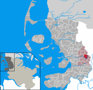
| Location of the municipality of Behrendorf in the district of North Friesland | ||
  |
||

Behrendorf ( Danish : Bjerndrup or Bjerrup , North Frisian : Bjarntoorp , flat : Beerndöbody ) is a municipality in the district of North Friesland in Schleswig-Holstein . The community has no other districts.
geography
Geographical location
Behrendorf is located in the middle of the Schleswigsche Geest landscape on the upper reaches of the Arlau River . The course of the river initially forms the eastern boundary of the municipality, and then the southern boundary as well.
geology
The soil in the municipality is part of the sand area ( ground moraine ) of the Geest . As a flowing water, the Arlau forms the main body of water management in the municipality.
Neighboring communities
| Sollwitt | Süderhackstedt | |
| Viöl |
.svg)
|
Bondelum |
| Immenstedt | Ahrenviöl | Ahrenviölfeld |
history
On April 1, 1934, the parish district of Viöl was dissolved. Their villages became independent communities, including Behrendorf.
Economy and Infrastructure
Agriculture
Historically, the municipal area has always been strongly characterized by agriculture . In addition to the predominant milk production , farm horse breeding also plays a formative role. Well-known horse breeders of the Holsteiner Horse Breeding Association are located on site.
Energy industry
Due to the structural change in agriculture, the generation of energy using wind energy and biomass is meanwhile also important. Several wind turbines were built in the village ; in addition, two biogas plants are operated.
traffic
Behrendorf is located off the federal trunk road network. The Schleswig-Holstein state road 28 runs through the village . This branches off from federal highway 200 to the east in the rural central town of Viöl .
Accessibility in public transport is severely restricted. The nearest train station for local transport is in Jübek on the Neumünster - Flensburg line or Husum - Kiel line . The closest long-distance traffic stop is Husum train station on the Marschbahn .
The place is otherwise only in school transport to and from school in Viöl approached (line 1043 Autokraft ).
Sports
Behrendorf is known far beyond the municipal boundaries for equestrian sports . The local riding and driving club Obere Arlau organizes several tournaments every year, some with international participation.
Web links
Individual evidence
- ↑ North Statistics Office - Population of the municipalities in Schleswig-Holstein 4th quarter 2019 (XLSX file) (update based on the 2011 census) ( help on this ).
- ↑ Aasbüttel - Bordesholm . In: Wolfgang Henze (ed.): Schleswig-Holstein topography: cities and villages of the country . 1st edition. tape 1 . Flying-Kiwi-Verl. Junge, Flensburg 2001, ISBN 3-926055-58-8 , p. 252 .
- ↑ State Statistical Office Schleswig-Holstein (Ed.): The population of the communities in Schleswig-Holstein 1867-1970 . State Statistical Office Schleswig-Holstein, Kiel 1972, p. 251 .
- ^ Historical municipality register Schleswig-Holstein: Notes on the municipality of Behrendorf (footnote) . ( Digitized version ).
Achtrup | Ahrenshöft | Ahrenviöl | Ahrenviölfeld | Alkersum | Almdorf | Arlewatt | Aventoft | Bargum | Behrendorf | Bohmstedt | Bondelum | Bordelum | Borgsum | Bosbull | Braderup | Bramstedtlund | Bredstedt | Breklum | Dagebüll | Drage | Drelsdorf | Dunsum | Elisabeth-Sophien-Koog | Ellhöft | Emmelsbüll-Horsbüll | Narrow Sands | Fresendelf | Friedrich-Wilhelm-Lübke-Koog | Friedrichstadt | Galmsbüll | Garding | Garding, parish | Goldebek | Goldelund | Gröde | Grothusenkoog | Haselund | Hattstedt | Hattstedtermarsch | Högel | Spar | Hooge | Hörnum (Sylt) | Horstedt | Hude | Humptrup | Husum | Immenstedt | Joldelund | Kampen (Sylt) | Karlum | Katharinenheerd | Klanxbüll | Klixbull | Koldenbüttel | Kolkerheide | Kotzenbüll | Ladelund | Langeneß | Langenhorn | Leak | Lexgaard | List on Sylt | Löwenstedt | Lütjenholm | Midlum | Mildstedt | Fog | Neukirchen | Nieblum | Niebüll | Norddorf on Amrum | Norderfriedrichskoog | North beach | Norstedt | Ockholm | Oevenum | Oldenswort | Oldersbek | Olderup | Oldsum | Ostenfeld (Husum) | Oster-Ohrstedt | Osterhever | Pellworm | Poppenbüll | Ramstedt | Rantrum | Reußenköge | Risum-Lindholm | Rodenäs | Sankt Peter-Ording | Schwabstedt | Schwesing | Seeth | Simonsberg | Sollwitt | Sönnebüll | Sprakebull | Stadum | Stedesand | Struckum | South end | Süderhöft | Süderlügum | South March | Sylt | Tating | Tetenbull | Tinningstedt | Tönning | Tümlauer-Koog | Uelvesbüll | Uphusum | Utersum | Viöl | Vollerwiek | Vollstedt | World | Wenningstedt-Braderup (Sylt) | Wester-Ohrstedt | Westerhever | Westre | Winnert | Wipe | Witsum | Wittbek | Wittdün on Amrum | Joke word | Wobbenbüll | Wrixum | Wyk on Föhr