
Wustrow (Mecklenburg Lake District)
| coat of arms | Germany map | |
|---|---|---|

|
Coordinates: 53 ° 14 ' N , 12 ° 58' E |
|
| Basic data | ||
| State : | Mecklenburg-Western Pomerania | |
| County : | Mecklenburg Lake District | |
| Office : | Mecklenburgische Kleinseenplatte | |
| Height : | 64 m above sea level NHN | |
| Area : | 42.93 km 2 | |
| Residents: | 713 (Dec. 31, 2019) | |
| Population density : | 17 inhabitants per km 2 | |
| Postal code : | 17255 | |
| Primaries : | 039828, 039832 | |
| License plate : | MSE, AT, DM, MC, MST, MÜR, NZ, RM, WRN | |
| Community key : | 13 0 71 167 | |
| Office administration address: | Rudolf-Breitscheid- Strasse 24 in 17252 Mirow |
|
| Mayor : | Heiko Kruse | |
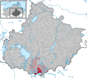
| Location of the municipality of Wustrow in the Mecklenburg Lake District | ||
  |
||

Wustrow is a municipality in the south of the Mecklenburg Lake District in southern Mecklenburg-Western Pomerania . The municipality is administered by the Mecklenburgische Kleinseenplatte office with its seat in Mirow .
geography
The municipality of Wustrows lies on the border with the state of Brandenburg in one of the regions in the Mecklenburg Lake District with the greatest number of lakes . Of the numerous lakes in the immediate vicinity of Wustrow, only the Rätzsee , the Gobenowsee , the Krummer Woklowsee , the Labussee , the Kleine Pälitzsee , the Klenzsee , the Plätlinsee and the Peetschsee are mentioned. The lakes in the southern part of the municipality (Canow district) are interconnected and part of the Müritz-Havel waterway . The entire area is an Eldorado for water sports enthusiasts, tourism is therefore of the utmost importance for the area. Extensive forests and rolling hills stretch between the lakes.
Districts
history
During earthworks and road construction, evidence was repeatedly found in the near and far vicinity that this area was inhabited very early. Settlements of the Germanic peoples could be proven, finds from the Iron Age supplemented the historical picture. Eventually, evidence of the settlement of Slavs near lowlands and lakes was found. Around 1250, farmers from Westphalia, Holstein and Friesland also settled in this area permanently.
Wustrow was first mentioned in a document on January 25, 1349. The place name comes from Slavic and means place or place on the island that flows around it, which refers to the location between Plätlinsee and Klenzsee .
During the Thirty Years War, the population suffered considerably and the number of business locations halved by 1664.
Around 1815, Wustrow's church records mentioned professions that refer to the work in the glassworks in the neighboring towns.
In Neu Canow , Grünplan and Canow there were glassworks until the end of the 18th century. Agriculture, forestry and fishing remained the most important source of income in this place.
In 1836 the Wustrower Feldmark was reorganized and at the same time the house owners received fields on a long lease. Since the division and reorganization of the fields also meant that meadows had to be allocated, these negotiations had lasted since 1827. Before that, the meadows were used for communal cultivation (guarding). 1922 was prepared by the leasehold law decreed that from time lease a ground lease was.
The size of the agricultural area per farm in the village was between 6 and 25 hectares. Difficult soil conditions, the often separate areas and constantly changing ownership conditions made cultivation difficult and reduced income.
In 1945 around 178 hectares were expropriated as a result of the land reform in Wustrow and given to 19 new farmers . The size of these agriculturally usable areas was between 6 and 11 hectares per new farmer site.
In 1953/54 six farmers from this place and the owners of the nearby chicken farm “fled the republic”. With a population of around 300, this was a decisive event. The abandoned farms were temporarily managed by the newly established local agricultural enterprise (ÖLB). After the first agricultural production cooperative was founded in Neudrosedow on September 1, 1955, these tasks and the staff were taken over.

In March 1960 the party resolutions led to the formation of agricultural production cooperatives (LPG), either type I or type III, which differed from one another in the way they kept livestock and thus the use of the stables. However, this did not automatically lead to overcoming the difficulties that arose from the fragmentation of the field marrow and the very rapidly changing soil conditions. Attempts to cultivate the different soils over a large area and in the same way repeatedly led to significant yield losses. Long-established farmers felt strengthened in their views on the previously practiced forms of farming. The difficulties that arose from the small stables that were jointly used after the merger were met with the construction of large facilities that were neither oriented towards the local climatic conditions nor always met the hygienic requirements ( cattle stables near Wustrow, large duck farm as successor to the Chicken farm, pig breeding and pig fattening houses).
Since the introduction of the municipal code in 1864, village schoolchildren were appointed to which a school council was assigned. After 1914 the designation mayor was introduced. This office was held by a shoemaker, several teachers and farmers. From September 24, 1946, there was an elected municipal parliament, initially consisting of 12 people. In 1990 the first free election took place in which 15 parties could be formed.
Seewalde am Gobenowsee was created in the 19th century from a steam brick building with agriculture belonging to Drosedow. By decree of the Grand Duke in 1904 the place was named Seewalde . The property was a long-term lease. The two-storey mansion dates from the 1920s. After around 1941 it was a healing and educational institute, was nationalized around 1949, later a boarding school, then a kindergarten teacher school and then a training and recreation center of the SED. After 1995 the building was given to the Protestant Lauenstein e. V. transferred back and a workshop for the disabled was created.
politics
Coat of arms, flag, official seal
The municipality has no officially approved national emblem, neither a coat of arms nor a flag. The official seal is the small state seal with the coat of arms of the state of Mecklenburg. It shows a looking bull's head with torn off neck fur and crown and the inscription "GEMEINDE WUSTROW * LANDKREIS MECKLENBURGISCHE SEENPLATTE".
Attractions
- Wustrow village church from 1897 based on plans by master builder Witzeck. Successor building of simple wooden churches. Formerly a branch church of Wesenberg, assigned to the Strasen parish in 1773, has been with Wesenberg for several years.
- Neo-Gothic brick village church from 1882 in Drosedow with a massive roof turret , in which the bell from 1860 is located.
- Half-timbered church Strasen from 1784 built by the forest engineer Draeseke; the tower was demolished in 1969.
- Half-timbered church Priepert from 1719; after war damage without a tower
- Wustrow parish and school house. The teachers lived here until the 1980s. In 1999 a home parlor was opened, which in 2008 was expanded to include the study and reference library of the writer Helmut Sakowski (1924–2005). Later this was taken over into the new school building (built around 1950), where a larger home parlor could be set up.
- Three steles from 1997 in memory of the death march of concentration camp inmates in April 1945, at the exit to Pälitzhof, in the center and at the entrance to the village; erected by young people under the guidance of the artist Wolf Leo.
- Two-storey Drosedow manor from the 19th century and park
- Sankt Hubertus hunting lodge in Drosedow built in 1904 in Art Nouveau style for Alfred Dührssen ; 1914 to 1945 center of the Drosedow stud, after 1945 residential building, sales point and kindergarten, after 1960 training facility; privatized, renovated and since 2004 pension.
- Gutshaus Neu Drosedow, a classicist, two-storey plastered building from the mid-19th century. The estate's culture barn is a location for the Mecklenburg-Western Pomerania Festival.
- Manor complex in Seewalde with a one-storey manor house from the 1920s and a park with an ice cellar made of field stones; after 1949 boarding school and recreation center, since 1998 expanded as a facility for the disabled.

Church in Wustrow

Church in Drosedow


economy
Major impulses for the development of the place resulted from tourism and agriculture. On the one hand, dirt roads that had previously been used after 1970, which made it easier for farmers to cultivate their fields, were converted into arable land in the course of large-scale cultivation, while on the other hand, previously unpaved country roads were given bitumen pavements. Among other things, this made it possible for schoolchildren to travel by bus.
Until around 1958, the wood from the surrounding forests was collected and sorted in a clearing on the nearby Klenzsee, so that it was then connected to rafts on the lake and transported away.
The machine rental station (MAS) set up after 1950 and later called the machine tractor station (MTS) on the outskirts of Wustrow has been closed. Only a few smaller craft and service companies are still available.
traffic
Wustrow is on the federal road 122 between Wesenberg and the Brandenburg Rheinsberg . In the east there is a road connection to the federal highway 96 (between Fürstenberg / Havel and Neustrelitz ). The next train station is in Wesenberg on the Mirow – Neustrelitz line . The connection to Wesenberg and Neustrelitz is during the week with the buses of MVVG ensured.
Personalities
- Alfred Dührssen (1862–1933), gynecologist and professor at the University of Berlin; In 1904 he had the Sankt Hubertus hunting lodge built in Drosedow.
literature
- Wustrow community (ed.): Wustrow - a gem in the Strelitz Kleinseenplatte. 1998
Web links
Individual evidence
- ↑ Statistisches Amt MV - population status of the districts, offices and municipalities 2019 (XLS file) (official population figures in the update of the 2011 census) ( help ).
- ^ Paul Kühnel: The Slavic place names in Meklenburg in year books of the Association for Mecklenburg History and Archeology . - Vol. 46 (1881), p. 130
- ↑ Main Statute, Section 1, Paragraph 2
Alt Schwerin | Altenhagen | Altenhof | Altentreptow | Ankershagen | Bartow | Basedow | Beggerow | Ownership | Blankenhof | Blankensee | Flower wood | Bollewick | Borrentine | Bredenfelde | Breesen | Breest | Briggow | Brunn | Buchholz | Stargard Castle | Burow | Bütow | Carpin | Cölpin | Dargun | Datzetal | Demmin | Eldetal | Rotten rust | Feldberger Seenlandschaft | Fincken | Friedland | Five lakes | Galenbeck | Gielow | Gnevkow | Godendorf | Goehren-Lebbin | Golchen | Gotthun | Grabowhöfe | Grammentin | Grapzow | Grischow | Large trowel | Groß Miltzow | Gross Nemerow | Large plastic | Groß Teetzleben | Grünow | Validity | Gülzow | High Wangelin | Hohenbollentin | Hohenmocker | Hohenzieritz | Holldorf | Ivenack | Jabel | Jürgenstorf | Kargow | Kentzlin | Kieve | Kittendorf | Little Thank You | Kletzin | Klink | Klocksin | Knorrendorf | Kratzeburg | Kriesow | Sublank | Kuckssee | Kummerow | Larz | Leizen | Lindenberg | Lindetal | Malchin | Malchow | Meesiger | Melz | Mirow | Möllenbeck | Möllenhagen | Mölln | Moltzow | Neddemin | Neetzka | Neubrandenburg | Neuenkirchen | Recalculation | Neustrelitz | Neverin | Nossendorf | Nossentiner Hut | Peenehagen | Penkow | Penzlin | Pragsdorf | Priborn | Priepert | Pripsleben | Rechlin | Ritzerow | Röbel / Müritz | Röckwitz | Rosenow | Sarov | Schloen-Dratow | Schönbeck | Schönfeld | Schönhausen | Black | Siedenbollentin | Siedenbrünzow | Sietow | Silz | Sommersdorf | Sponholz | Staven | Stavenhagen | Steer | Südmüritz | Torgelow am See | Trollenhagen | Tützpatz | Userin | Utzedel | Forgive | Voigtsdorf | Vollrathsruhe | Walow | Waren (Müritz) | Warrenzin | Werder | Wesenberg | Wildberg | Woggersin | Wokuhl-Dabelow | Wolde | Woldegk | Wulkenzin | Wustrow | Zettemin | Zirzow | Zislow