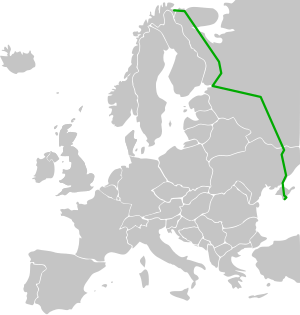
Europastraße 105
| Europastraße 105 | |

|
|
| map | |
| Basic data | |
| Overall length: | 3876 km |
|
States : |
|
|
Course of the road
|
|
The Europastraße 105 (short: E 105 ) runs in a north-south direction through Eastern Europe. It begins in Norway on the Barents Sea and leads via Saint Petersburg , Moscow and Ukraine to the Crimea peninsula in the Black Sea . It connects the remote Murmansk Oblast in northern Russia with the rest of the country as well as the two Russian metropolises Moscow and Saint Petersburg. South of Moscow, it connects the Russian capital with the eastern Ukrainian industrial region and the Crimea tourist region, which is important within the CIS . It is more of national and regional than of international importance.
course
| 0 km | Kirkenes |
| RUSSIA, Murmansk Oblast , continued as R 21 | |
| 60 km | Sapolyarny |
| 228 km | Murmansk |
| 363 km | Montchegorsk |
| 474 km | Kandalaksha |
| Republic of Karelia | |
| 778 km | Kem |
| 1010 km | Medvezhyegorsk |
| 1217 km | Petrozavodsk |
| Leningrad Oblast | |
| 1414 km | Lodeinoje Pole |
| 1633 km | Saint Petersburg, continued as M 10 |
| Novgorod Oblast | |
| 1829 km | Novgorod |
| 1969 km | Waldai |
| Tver Oblast | |
| 2060 km | Wyschni Volochek |
| 2194 km | Tver |
| Moscow Oblast | |
| 2358 km | Moscow, continued as M 2 |
| Tula Oblast | |
| 2558 km | Tula |
| Oryol Oblast | |
| 2741 km | Oryol |
| Kursk Oblast | |
| 2901 km | Kursk |
| Belgorod Oblast | |
| 3038 km | Belgorod |
| UKRAINE , continued as M 20 | |
| 3119 km | Kharkiv , continued as M 18 |
| 3313 km | Novomoskovsk near Dnipro |
| 3416 km | Zaporizhia |
| 3529 km | Melitopol |
| 3766 km | Simferopol |
| 3876 km | Yalta |
Others
The Ukrainian state transport company Krymskyj trolejbus operates the longest trolleybus line in the world on the southern section of European route 105 . The overland route is 86.5 kilometers long and leads from Simferopol via Alushta to Yalta.

