
Bad Mergentheim
| coat of arms | Germany map | |
|---|---|---|

|
Coordinates: 49 ° 29 ' N , 9 ° 46' E |
|
| Basic data | ||
| State : | Baden-Württemberg | |
| Administrative region : | Stuttgart | |
| County : | Main-Tauber district | |
| Height : | 206 m above sea level NHN | |
| Area : | 129.97 km 2 | |
| Residents: | 23,704 (Dec. 31, 2018) | |
| Population density : | 182 inhabitants per km 2 | |
| Postal code : | 97980 | |
| Primaries : | 07931, 07930, 07932, 07937, 07938 | |
| License plate : | TBB, MGH | |
| Community key : | 08 1 28 007 | |
| LOCODE : | DE BME | |
| City structure: | Core city and 13 districts | |
City administration address : |
Bahnhofplatz 1 97980 Bad Mergentheim |
|
| Website : | ||
| Lord Mayor : | Udo Glatthaar ( CDU ) | |
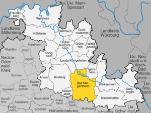
| Location of the city of Bad Mergentheim in the Main-Tauber district | ||
  |
||


Bad Mergentheim (in the regional dialect Märchedol [ ˈmɛʀxəˌdɔːl ]) is a town on the Tauber in the Franconian north - east of Baden-Württemberg , about 35 km southwest of Würzburg and 56 km north-east of Heilbronn . Before the state of Baden-Württemberg was formed, it was the northernmost city in Württemberg . Today (as of December 31, 2016) it is the largest city in the Main-Tauber district and a medium-sized center in the Heilbronn-Franconia region .
Bad Mergentheim was first mentioned in 1058 and was the official seat of the Grand Master of the Teutonic Order from 1526 to 1809 . The city has been called Bad since 1926 ; since April 1, 1975 it has been a major district town . Bad Mergentheim has entered into an agreed administrative partnership with the communities of Assamstadt and Igersheim .
geography
location
Bad Mergentheim is located in Tauberfranken , a part of Franconia in Baden-Württemberg in a valley widening of the Tauber at the confluence of the Wachbach . The core city is located directly on the Tauber, while a large part of the districts are in side valleys.
Neighboring communities
Neighboring communities of Bad Mergentheim are clockwise
- in the Main-Tauber district: Assamstadt , Boxberg , Lauda-Königshofen , Igersheim, Weikersheim and Niederstetten
- in the Hohenlohe district : Mulfingen and Dörzbach
City structure
Bad Mergentheim consists of the core town of Bad Mergentheim and 13 other districts and the districts belonging to the districts that have belonged to Bad Mergentheim since the municipal reform in the 1970s (population figures as of March 31, 2004):
![]() Map with all coordinates of the places in the city of Bad Mergentheim: OSM
Map with all coordinates of the places in the city of Bad Mergentheim: OSM
- Bad Mergentheim-Stadt (12,488 inhabitants; 16.512 km²) with the city of Bad Mergentheim ( ⊙ ) and the residential areas Drillberg ( ⊙ ) and Willinger Tal ( ⊙ ) as well as the abandoned town of Riet
- Althausen (596; 12.642 square kilometers) with the village Althausen ( ⊙ ), the farm Üttingshof ( ⊙ ) and the dialed location Tainbach or Your book
- Apfelbach (351; 9.105 km²) with the village of Apfelbach ( ⊙ ) and the farmstead Staatsdomäne Apfelhof ( ⊙ ) as well as the abandoned village of Hof
- Dainbach (373, the only district of Baden; 7.276 km²) with the village of Dainbach ( ⊙ )
- Edelfingen (1357; 7.480 km²) with the village of Edelfingen ( ⊙ )
- Hachtel (357; 8.261 km²) with the village of Hachtel ( ⊙ ) and the abandoned village of Igelstrut
- Herbsthausen (195) with the village of Herbsthausen ( ⊙ )
- Löffelstelzen (1000; 5.093 km²) with the village of Löffelstelzen ( ⊙ ) and the abandoned villages of Kettenburg and Laubertsbronn
- Markelsheim (1986; 15.118 km²) with the village of Markelsheim ( ⊙ ), the living space Schneidmühle ( ⊙ ) and the abandoned town of Asbach
- Neunkirchen (850; 2.557 km²) with the village of Neunkirchen ( ⊙ )
- Rengershausen (484; 10.669 km²) with the village of Rengershausen ( ⊙ ) and the lost village of Buchele
- Rot (263; 8.183 km²) with the village of Rot ( ⊙ ) and the districts of Dörtel ( ⊙ ) and Schönbühl ( ⊙ )
- Stuppach (683; 15.301 km²) with the village of Stuppach ( ⊙ ) and the districts of Lillstadt ( ⊙ ) and Lustbronn ( ⊙ )
- Wachbach (1304; 8.188 km²) with the village of Wachbach ( ⊙ ) and the Schafhof residential area ( ⊙ )
With the exception of Bad Mergentheim-Stadt, the districts with associated districts form localities within the meaning of the Baden-Württemberg municipal code ; In the localities of Rot and Stuppach, the false choice of suburbs is used accordingly. The districts and districts each form residential districts within the meaning of the Baden-Württemberg municipal code.
The 14 districts are divided into five residential districts in accordance with the Baden-Württemberg municipal code:
- Residential district I with Bad Mergentheim-Stadt
- Residential district II with Althausen, Neunkirchen, Rengershausen and Stuppach
- Residential district III with Dainbach, Edelfingen and Löffelstelzen
- Residential district IV with Apfelbach and Markelsheim
- Residential district V with Hachtel, Herbsthausen, Rot and Wachbach
Spatial planning
Bad Mergentheim forms a middle center within the Heilbronn-Franken region, in which Heilbronn is designated as a regional center . The municipalities in the south of the Main-Tauber district Ahorn , Assamstadt, Boxberg, Creglingen , Igersheim, Niederstetten and Weikersheim also belong to the central area of Bad Mergentheim .
Protected areas
There are three landscape and four nature reserves in Bad Mergentheim :
- Igersheim landscape protection area : 497.4 ha; Bad Mergentheim and Igersheim districts; since 1979.
- Bad Mergentheim landscape protection area : 4,044.0 ha; Bad Mergentheim district; since 2005.
- Conservation area Weikersheim : 2718.0 ha; Bad Mergentheim, Creglingen, Niederstetten and Weikersheim districts; Since 1993.
- Birkenberg nature reserve : 26.0 ha; City of Bad Mergentheim, Mergentheim and Edelfingen districts
- Kleines Knöckle nature reserve : 6.1 ha; City of Bad Mergentheim, district Althausen
- Neuhaus nature reserve : 79.4 ha; Mergentheim and Igersheim districts
- Ringelstaler-Weinhalde nature reserve : 90 ha; City of Bad Mergentheim, district Edelfingen and city of Lauda-Königshofen, district Unterbalbach
In addition, there are a total of 59 objects protected as natural monuments in the area of the city of Bad Mergentheim .
The following FFH areas are partly located in the district of Bad Mergentheim: Jagsttal Dörzbach-Krautheim , Taubergrund Weikersheim-Niederstetten and Westlicher Taubergrund .
The Bad Mergentheim I water protection area, designated by ordinance of November 7, 1994 with WSG no. 128129 covers a protected area of 4,070.64 hectares. This makes it one of the largest water protection areas in the Main-Tauber district .
Division of space

According to data from the State Statistical Office , as of 2014.
history

middle Ages
Mergentheim was first mentioned in a document on June 12, 1058 as "Mergintaim" ( comitatus Mergintaim in pago Tubergewe , County of Mergentheim in Taubergau ). During the time of the tribal duchies , the city belonged to the Duchy of Franconia . In 1219 the brothers Andreas, Friedrich and Heinrich von Hohenlohe donated property and rights in Mergentheim to the Teutonic Order, so it became a commander of the Teutonic Order and the foundation stone for the city's development and for the Teutonic Order residence was thus laid. In 1280 the settlement was granted customs rights by Duke Johann von Lothringen. On July 2, 1340 Mergentheim was raised to the city by Emperor Ludwig of Bavaria at the request of the German master Wolfgang von Nellenburg .
Modern times
From 1526 to 1809 Mergentheim was the headquarters of the Teutonic Order (seat of the Grand Master ) and belonged to the Deutschordensballei Franken . Its chamber property was the mastery of Mergentheim .
From the witch hunts in Mergentheim from 1539 to 1665 74 victims are known by name. 69 people did not survive the witch trials . On September 11, 1629, Magdalena Nachtrab , wife of the mayor and pharmacist Paul Nachtrab, was arrested and executed on September 22. The amount confiscated was 1,800 guilders. From the witch persecution in Markelsheim from 1617 to 1638 91 victims are known by name. 81 did not survive the witch trials.
In the 17th and 18th centuries, sources refer to the former Mergentheim as Mergenthal (cf. Märchedol in dialect) or Marienthal , in Latin as Mariae Domus (Marienhaus) or Vallis Mariae virginis (Valley of the Virgin Mary).

Since 1809 the city belonged to the Kingdom of Württemberg and became the seat of the Württemberg Oberamt of the same name . An uprising against the new rule that broke out in June 1809, which was sparked by the recruitment process, was suppressed by Württemberg troops , the castle remained intact and the ringleaders were sentenced to death. In 1826 the mineral springs were rediscovered, which made Mergentheim a bathing town. In 1869, when the Crailsheim – Königshofen railway was opened, the city was connected to the railway network. Mergentheim was also a garrison of the Württemberg Army. For a time, this was the location of the 2nd Battalion of the 4th Regiment . In 1926, the city was awarded the title bathroom . In 1934 the Mergentheim Oberamt was renamed the Mergentheim district and in 1938 transferred to the Mergentheim district .
During the Reichspogromnacht from November 9th to 10th, 1938, the Bad Mergentheim synagogue was soiled and demolished. For example - as in many other synagogues - the windows here were also destroyed, the same thing happened with the shop windows of the Springmann shoe store in Bahnhofstrasse by NSKK and SA members. Several Jewish men were taken into " protective custody ". In 1978 a memorial to these events was erected on the grounds of the Protestant parish. A plaque commemorates the victims of the Shoah in the courtyard of the St. Bernhard elementary and secondary school at Holzapfelgasse 15 .

After the end of the Second World War in 1945, Bad Mergentheim belonged to the American zone of occupation . The American military administration set up a DP camp to accommodate so-called Displaced Persons (DP). Most of them were from Lithuania .
The Bad Mergentheim district existed until the district reform on January 1, 1973, when it became part of the new Main-Tauber district. As a result, Bad Mergentheim lost its function as a district town in favor of Tauberbischofsheim .
From 1972, in the wake of were local government reform , some 13 to date independent communities with other associated living quarters incorporated, to Bad Mergentheim. As a result, the population of the city of Bad Mergentheim exceeded the limit of 20,000 in 1975. As a result, the city administration applied for a major district town, which the state government of Baden-Württemberg decided with effect from April 1, 1975.
From 1962 to 1993, the headquarters of the Bundeswehr tank brigade 36 "Mainfranken" was stationed in the city .
population
Religions
Christianity

The area of the city of Bad Mergentheim originally belonged to the diocese of Würzburg . The Reformation was initially unable to prevail in the original city, but the Lutheran creed was introduced during the Swedish era when the Catholic pastor converted to Protestantism. The services were held first in St. John's Church , then in St. Mary's Church. The Catholic services were held in the castle church at that time. After the return of the Grand Master of Stadion, however, the city was almost completely re-Catholicized again. The community initially belonged to the diocese of Würzburg, then after the transition to Württemberg from 1814 it became part of the general vicariate of Ellwangen before it was assigned to the newly founded diocese of Rottenburg (today Rottenburg-Stuttgart ) in 1821/1827 . Bad Mergentheim became the seat of a deanery . Today's parishes in the city area belong to two pastoral care units. Pastoral care unit 1a includes the parishes of St. Gumbert Apfelbach, St. Johann Baptist Bad Mergentheim with a branch chapel in Edelfingen, The Holy Trinity Löffelstelzen and St. Kilian Markelsheim, and pastoral care unit 1b includes the parishes Maria Krönung Stuppach, St. Leonhard Rengershausen, branch parish St. Pius Laibach, St. Georg Wachbach, St. Petrus and Paulus Rot and Filialkirchengemeinde Mariä Himmelfahrt Hachtel.
The former Baden district of Dainbach has a neo-Gothic Catholic chapel from 1900. The parishioners belong to the neighboring Baden parish of Unterschüpf and thus to the Archdiocese of Freiburg . The districts of Althausen, Edelfingen, Neunkirchen and Herbsthausen are predominantly Protestant places.
After the transition to Württemberg, a Protestant congregation was founded again in the core town of Bad Mergentheim, which received the castle church as a place of worship in 1815. The congregation got its own pastor from 1825. The congregation has been a member of the Evangelical Church in Württemberg from the start . Bad Mergentheim was at that time the seat of the Oberamt, the church administration, the Dean's Office, was and remained in Weikersheim. Therefore the parish Bad Mergentheim belongs to the church district Weikersheim to this day .
In addition to the core town of Bad Mergentheim, the districts of Althausen, Edelfingen, Herbsthausen, Markelsheim, Neunkirchen and Wachbach each have their own Protestant parishes or churches. The latter is also responsible for Hachtel. The Protestant parish of Dainbach still belongs to the Evangelical Church in Baden (Boxberg church district).
In some of today's districts, the denominational development is different: Edelfingen and Wachbach were predominantly Lutheran because they were administered together with the Lords of Adelsheim. Neunkirchen was a Würzburg-Hohenlohe condominium and therefore also had a strong Lutheran congregation.
Free church communities
In addition to the two large churches, free-church congregations are also represented in Bad Mergentheim , including a congregation of the Seventh-day Adventist Community and the Evangelical Free Church Community ( Baptists ) founded in 1991 . A New Apostolic congregation is also based in Bad Mergentheim. There is also a Baha'i community house , an old Pietist community and a Liebenzeller community .
Judaism
There were Jews in Mergentheim from the Middle Ages up to the time of National Socialism.
Mergentheim was the seat of a rabbi since the 18th century . From 1828/32 to 1939 there was one of the Württemberg district rabbinates in Mergentheim .
The Jewish communities of Markelsheim , Neunkirchen and Wachbach existed in the Bad Mergentheim districts .
Incorporations
The following communities were incorporated into Bad Mergentheim. Unless otherwise stated, they all belonged to the Mergentheim district :
- January 1, 1972: Althausen, Apfelbach, Löffelstelzen, Markelsheim, Neunkirchen
- February 15, 1972: Rengershausen, Stuppach
- December 1, 1972: Dainbach (Tauberbischofsheim district)
- September 1, 1973: Herbsthausen, Rot
- December 31, 1974: Hachtel, Wachbach
- January 1, 1975: Edelfingen
Population development
Population figures according to the respective area. The numbers are estimates, census results or official updates from the respective statistical offices ( main residences only ).
|
|
 
|
In the long term, the prognosis of the State Statistical Office shows a continuous increase in population.
politics

As a major district town, Bad Mergentheim is subject to the technical supervision of the regional council. The district president in Stuttgart is responsible . The district otherwise responsible for municipal supervision is only responsible for legal supervision. This leads to greater independence compared to other cities and municipalities belonging to the district.
Bad Mergentheim is in the Bundestag constituency 276 Odenwald-Tauber.
Municipal council
The parish council usually has 28 honorary members who are elected for five years. The municipal councils use the designation city council. The number of members can increase through compensatory seats (total 2019: 33 seats; 2014: 31). In addition, the mayor acts as the municipal council chairman with voting rights.
The Fake Teilorteschahl guarantees a certain number of seats in districts of a municipality in Baden-Württemberg. In Bad Mergentheims, several districts are grouped into residential districts: The main town of Bad Mergentheim-Stadt forms residential district I, the districts Althausen, Neunkirchen, Rengershausen and Stuppach together form residential district II, residential district III consists of Dainbach, Edelfingen and Löffelstelzen, residential district IV becomes formed by Apfelbach and Markelsheim, and residential district V includes Hachtel, Herbsthausen, Rot and Wachbach. In municipal elections, Bad Mergentheim-Stadt (residential district I) is entitled to at least 16 seats, and at least three municipal councilors each come from the four other residential districts.
The 2019 local elections led to the following result (in brackets: difference to 2014):
| Municipal Council 2019 | ||||
|---|---|---|---|---|
| Party / list | Share of votes | Seats | ||
| CDU | 42.3% (−7.5) | 14 (−1) | ||
| Green | 20.5% (+5.4) | 7 (+2) | ||
| FW | 19.2% (+1.5) | 6 (± 0) | ||
| SPD | 11.1% (−2.8) | 4 (± 0) | ||
| FDP | 5.3% (+5.3) | 2 (+2) | ||
| Turnout: 55.3% (+4.6) | ||||
mayor

The mayor was originally at the head of the community . After the town was raised, the mayor and mayor took his place. In 1784 the city administration was reorganized. After that there was a city court with a city school body as chairman. He was assisted by three assessors. After the transfer to Württemberg, the city school, later the mayor, headed the city administration. Since April 1, 1975, when Bad Mergentheim became a major district town, the mayor has held the title of mayor . He is directly elected for eight years. He is the chairman of the municipal council , which is elected for five years.
Udo Glatthaar has been Lord Mayor of Bad Mergentheim since 2011 . In February 2019 he was re-elected with 93.33 percent of the vote.
See also: List of Mayors of Bad Mergentheim
coat of arms
The coat of arms of the city of Bad Mergentheim shows “a continuous black cross in silver, covered with a gold cross, a black eagle in the gold heart shield; in the corners above a six-pointed, sinking red star, below a five-petalled red rose ”. The city flag is red and white.
The city coat of arms is hundreds of years old and was officially established during the blazon in 1942. It is the Hochmeister cross , which is derived from the Hochmeister coat of arms. The stars and roses are symbols of Mary, who is the patroness of the order. The city flag was only awarded on April 17, 1967 by the Ministry of the Interior of Baden-Württemberg .

Town twinning
Bad Mergentheim maintains partnerships with the following cities:
- Digne-les-Bains , Alpes-de-Haute-Provence , France, since June 24, 1962
- Sainte-Marie-du-Mont , Normandy , France, since May 28, 1967 (partnership with the Edelfingen district, incorporated in 1975)
- Fuefuki , Japan - "Flag friendship" with the formerly independent community of Isawa , since May 26, 1991 - Affirmation of friendship with Fuefuki on October 17, 2007
- Borgomanero , Novara Province , Italy, since September 10, 2005
Administrative community
The city of Bad Mergentheim, together with the municipalities of Assamstadt and Igersheim, forms the agreed administrative community of Bad Mergentheim to handle their administrative business together .
Economy and Infrastructure
traffic
Street
Bad Mergentheim can be reached via the Autobahn 81 Würzburg - Stuttgart (Boxberg, Ahorn or Tauberbischofsheim junctions).
The urban area is opened up by federal highways 19 ( Eisenach - Mellrichstadt - Würzburg - Bad Mergentheim - Ulm - Oberstdorf ) and 290 (Tauberbischofsheim - Bad Mergentheim - Aalen , Ostalbkreis).

Public transport
Bad Mergentheim is on the Crailsheim – Königshofen railway line . From its opening in 1869 until the end of the regional railway era in 1920, the station had extensive facilities due to its special importance as a transfer station between the Royal Württemberg State Railways and the Grand Ducal Baden State Railways .
On January 1, 2006, the line and operations were transferred to the Deutsche Bahn subsidiary Westfrankenbahn . On weekdays there is an approximate hourly service to Crailsheim and alternating between Aschaffenburg and Würzburg.
There are connections to the long-distance passenger rail transport of Deutsche Bahn in Würzburg and Crailsheim. Between 1968 and 1989 there were also direct through car connections with Hamburg and Dortmund.
Local public transport is served by several bus routes on behalf of the Verkehrsgemeinschaft Main-Tauber (VGMT) in the Verkehrsverbund Rhein-Neckar (VRN).
Viticulture
The district of Markelsheim is a renowned wine village in the Taubertal and the seat of Weingärtner Markelsheim eG. Wine was also grown in Bad Mergentheim until the 1940s. There the cultivation was stopped due to damage and insufficient care (consequences of the war) as well as acute phylloxera infestation and a lack of capital. Parts of the former vineyards were used to expand the spa business in later years.
See also Württemberg (wine-growing region) and Württemberg Wine Route
Medicinal waters

On October 13, 1826, the shepherd Franz Gehrig discovered today's Wilhelmsquelle. In the years that followed, further springs were developed, so today there are three drinking springs with mineral water and one bathing spring with brine.
- Albert spring, sodium chloride sulfate acid, drilling depth 31 m
- Karlsquelle, sodium chloride sulphate water, also available in bottles, drilling depth 27 m
- Paulsquelle, sodium chloride acid, only for bath therapy, drilling depth 550 m
- Wilhelmsquelle, sodium-calcium-sulphate-chloride-water, drilling depth 9 m
media

The daily newspaper in Bad Mergentheim is the Fränkische Nachrichten and the Tauber-Zeitung , a local edition of the Fränkische Nachrichten from Tauberbischofsheim, which get their national pages from Mannheimer Morgen .
The broadcaster Radio Ton operates a second studio in Bad Mergentheim that delivers local news.
The Bad Mergentheim (Löffelstelzen) transmitter is located near the Löffelstelzen district (on the Ketterwald), with a reinforced concrete tower for broadcasting television and radio programs in the area of Südwestrundfunk (SWR). The basic network transmitter mainly supplies the Main-Tauber district and neighboring areas. The following programs are broadcast on VHF with 10 kW: SWR1 Baden-Württemberg (87.8 MHz), SWR2 (93.2 MHz), SWR3 (99.7 MHz), SWR4 Baden-Württemberg (105.5 MHz) and DASDING ( 100.5 MHz) with 40 watts and radio sound (103.5 MHz) with 20 kW. In DAB frequency block 12B, the nationwide programs of Digital Radio Südwest are broadcast with 8 kW. There are also TV channels (DVB-T) on channels 26 (DasErste BW, EinsPlus, Arte, Phoenix), 23 (ZDF, 3sat, Kika / ZDFneo, ZDFinfo) and 50 (SWR BW, BR, HR, WDR) on the tower ).
Court, authorities and institutions
Bad Mergentheim has a notary's office and a district court , which is subordinate to the District Court of Ellwangen and the Higher Regional Court of Stuttgart . It also has a branch office of the Tauberbischofsheim tax office and a branch office (vehicle registration office) of the Main-Tauber district district office.
The city is also the seat of the Mergentheim deanery of the Rottenburg-Stuttgart diocese. In addition to the Caritas Hospital Bad Mergentheim , a general hospital , there are several sanatoriums and health clinics in Bad Mergentheim, including the Diabetes Center Mergentheim and a specialist diabetes hospital .
Until the mid-1990s, Bad Mergentheim was also a garrison town and location of the Panzer Brigade 36 "Mainfranken" and other units of the 12th Panzer Division .
education
Bad Mergentheim has had a campus of the Baden-Württemberg Cooperative State University Mosbach since 2002 . Business studies are offered in the fields of international business, industrial engineering and health management. There is also a seminar for didactics and teacher training (elementary and secondary schools) in Bad Mergentheim.
At state, general schools Bad Mergentheim has a high school ( German Order of High School ), a secondary school ( Copernicus -Realschule ), a special school ( Lorenz Fries -Schule ), a secondary school ( Eduard-Mörike -Schule ), a primary and secondary school ( Ottmar Schönhuth School Wachbach) and four primary schools (Bad Mergentheim Stadtmitte, Kirchberg Primary School Stuppach / Neunkirchen , Edelfingen and Markelsheim). There is also a youth music school and a community college .
In Bad Mergentheim there is also a vocational school center with a commercial and commercial school, as well as the vocational school for nutrition, care, education (EPE), which is sponsored by the Main-Tauber district . With the information technology, the technical, the nutritional science, the social science and the business high school, this also includes five vocational high schools .
The school offer is rounded off by the Catholic elementary and secondary school St. Bernhard , the evening secondary school Bad Mergentheim, the Kolping vocational college , the state-recognized college for physiotherapy at the Bad Mergentheim educational center and the educational center (vocational school for nursing professions / advanced and advanced training center) on Caritas Hospital Bad Mergentheim.
Culture and sights
Teutonic Order Castle

Equestrian staircase in the Teutonic Order Castle

Twin house and farm pharmacy on the market square

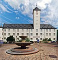
Market square with old town hall and Milchlingsbrunnen

Marienkirche


The Kulturforum, together with the departments of the city archive, the city library and the courtyard, forms the basis for the cultural life of Bad Mergentheim. It is a meeting place, gallery, concert hall and stage.
tourism
Trunk roads
Bad Mergentheim is on the " Romantic Road ".
Biking and hiking trails
In addition, the Taubertal cycle path , the Taubertal panorama path and the 180 km long Jakobsweg Main-Taubertal route lead through the city.
theatre
In the Kursaal Bad Mergentheim there are also theater performances.
Museums

- The Teutonic Order Museum in the Teutonic Order Castle presents the history of the Teutonic Order , the history of Bad Mergentheim , the Mörike Cabinet, the Neolithic Department in the Taubertal , a doll's house collection and the Adelsheim antiquity collection. The museum's collection also includes Rehden Castle from the Kulmerland, reconstructed by Albrecht Duwe on a scale of 1:50 . Also worth mentioning is the Berwart stairs, a spiral staircase built by Blasius Berwart in 1574 .
- The Münsterschatz Museum on the first floor above the sacristy of the St. Johannes Baptist Minster shows liturgical vessels and utensils from the late Gothic to the present day.
- Permanent exhibition "Leadership culture around the Trillberg - then and now" in the Würth industrial park on the site of the former Teutonic barracks . The exhibition aims to use historical examples to illustrate good and bad forms of leadership culture.
- The Ottmar-Mergenthaler memorial was set up in the town hall of the Hachtel district . The watchmaker Ottmar Mergenthaler , born in Hachtel, invented the Linotype typesetting machine in the USA in 1886 . This line typesetting and casting machine for characters, which was revolutionary at the time, significantly accelerated typesetting, especially for books and newspapers. The museum is dedicated to the work of Ottmar Mergenthaler.
- In the parish church of the Stuppach district is the Stuppach Madonna by Matthias Grünewald from 1519, one of the most important late Gothic paintings in Germany.
Buildings

Sights are above all the Deutschordensschloss (official name Deutschordenschloß ) with its baroque church, the minster church of St. Johannes Baptist and the characteristic town hall, which is the city's landmark. Since there has been no war damage since the Schmalkaldic War (1556/1557; fire in the town hall) (Mergentheim was a hospital town during World War II), it has retained its medieval to baroque townscape.
Also famous is the Stuppach Madonna by the painter Matthias Grünewald, a painting that was transferred from Bad Mergentheim to the Catholic Church of Maria Krönung in Stuppach, built in 1607 in 1812. There is a moated castle in the Wachbach district. Other churches in the city are:
Protestant churches
- Castle Church, Mergentheim
- Althausen, a classical hall church with a late Gothic winged altar
- Dainbach, a medieval building with a baroque nave from 1739
- Edelfingen, church built in 1872 instead of an old previous building
- Herbsthausen, at its core a medieval Johanneskirche with a choir tower, which was changed and renovated in 1619, 1703 and 1873 ff
- Neunkirchen, a neo-Romanesque church from 1822/23 and
- Wachbach, a Romanesque choir tower church, built around 1050
Catholic churches

- Maria Hilf church (monastery church)
- Marienkirche
- Minster St. Johannes
- Wolfgang Chapel at the Wolfgang Bridge over the Tauber
- Apfelbach, St. Gumbert (built in 1775, later refurbished)
- Edelfingen (chapel rebuilt from 1851/51 after being destroyed in the war)
- Hachtel (Assumption of the Virgin Mary built in neo-Gothic style from 1869 and painted in 1901)
- Löffelstelzen (For the Most Holy Trinity, built in 1660 in the early Baroque style)
- Markelsheim, a new building from 1958 with a free-standing tower (the old Gothic parish church in the cemetery was demolished)
- Rengershausen (St. Leonhard built 1792)
- Red (St. Peter and Paul built 1652/54)
- Stuppach (Coronation of the Virgin, built in 1607 in late Gothic style, houses a world-famous Madonna painting by Matthias Grünewald, known as the Stuppacher Madonna)
- Wachbach (St. Georg built in 1906 in the neo-Romanesque style)
Parks

- Castle Park
- The palace park was realized from 1791 to 1805 according to the designs of the knight Carl Caspar Reutter von Weyl and the court gardener Franz Joseph Hüller. In terms of style and history, the park is one of the pre-romantic-sentimental landscape gardens. The imposing plane tree avenue in the outer castle courtyard, which was laid out around 1800, leads through the gate in the east into the castle park, directly into the geometrically designed plant and kitchen garden. On the right is an English garden with varied paths. Meadows with groups of trees and solitary trees form wide garden spaces and open up interesting lines of sight. The lake with the poplar island, which cites a motif from the French park of Ermenonville, forms a scenic focus. After the Teutonic Order withdrew in 1809, the palace grounds underwent numerous changes. In addition, the Ulm-Würzburg railway line, which opened in 1869, cut the site with a railway embankment. The state of Baden-Wuerttemberg aims to gradually restore the palace gardens to what it was in 1800. By 2000, four sections of a ten-phase park maintenance facility from 1990 had been completed.
- Spa gardens
- The spa park with a total area of 160,000 m² houses u. a. a rose garden with 27 types of noble roses , a therapy park , a herb garden , a lapidarium , the sound garden and a Kneipp facility at the house of the spa guest (see also: List of public Kneipp facilities in the Main-Tauber district ). In 1996, a horticultural master from the twin town of Isawa laid out a Japanese garden with small waterfalls, Japanese plants and an arched bridge made of granite between the upper entrance to the spa park and the Solymar bathing park . In 2003 the Kurpark was chosen by an independent jury as one of the ten most beautiful parks in Germany. The Parkhotel Bad Mergentheim was built next to the park in 1983 (architect Justus Dahinden ).
- wildlife Park
- On a hill in the forest, about 1.5 kilometers southeast of the city center, the Bad Mergentheim Wildlife Park is located on an area of around 35 hectares, with over 70 different animal species native to Europe, including a pack of wolves with up to 30 animals.
Sports
Solymar thermal baths , three outdoor pools, riding hall, tennis courts, indoor tennis center, indoor go-kart track, golf course, various sports fields and clubs.
Regular events

- Folk festival
- City festival
- Markelsheim Wine Festival
- St. George's Day, a meeting of the German championships from Austria and Germany , which takes place annually in spring
- European singing competition Debut of Wittenstein AG (September / October)
- City run
- Festival of lights in the spa gardens
- Songs in the castle
- Christmas Market
Personalities
Well-known sons and daughters of Bad Mergentheim as well as other personalities associated with the city are listed in the list of personalities of the city of Bad Mergentheim .
Others
In order to relieve the high and German master Maximilian Franz von Österreich from his homesickness for his hometown Vienna , the bells of the cathedral and the castle church were coordinated in the 18th century so that they sound like St. Stephen's Cathedral when they ring together . Even today, the bells of both churches ring together for 15 minutes every Saturday at 3 p.m.
On June 12, 1990, Bad Mergentheim took over the sponsorship of a Boeing 737-300 from Lufthansa with the aircraft registration D-ABXZ. The machine has now been taken out of service. Since the end of 2019, the successor to the European route network has been a Bombardier CRJ-900 with the registration D-ACNO, which is stationed at Munich Airport, and bears the name "Bad Mergentheim".
literature
- Bernhard Klebes: The Teutonic Order in the Mergentheim region in the Middle Ages. Coming, city and territorial rule (1219/20 - approx. 1525) . Sources and studies on the history of the Teutonic Order. Vol. 58. Elwert, Marburg 2002. ISBN 3-7708-1219-0
- Daniela Lippert: Bad Mergentheim. A walk through the city . Bad Mergentheim 2008. ISBN 978-3-934223-31-8
- Ulrich von Sanden: "Oh, here, the world is so light". The healing springs of Bad Mergentheim . In: Cult baths and bath culture in Baden-Württemberg . Edited by W. Niess, S. Lorenz. Filderstadt 2004. ISBN 3-935129-16-5
- Ottmar Schönhuth : Chronicle of the former Teutonic Order town of Mergentheim, from documented sources . Mergentheim 1857 ( e-copy ).
- Ottmar Schönhuth : The churches and chapels of the former Teutonic town of Mergentheim . 1854 ( e-copy ).
- Heinz Stoob : Bad Mergentheim city map . German city atlas. Vol. 1. 1. Part. Acta Collegii Historiae Urbanae Societatis Historicorum Internationalis - Series C. On behalf of the Board of Trustees for Comparative Urban History e. V. and with the support of the Deutsche Forschungsgemeinschaft ed. by Heinz Stoob, Wilfried Ehbrecht, Jürgen Lafrenz and Peter Johanek. Dortmund-Altenbeken 1973. ISBN 3-89115-301-5
- Johann Kaspar Bundschuh : Neunkirchen . In: Geographical Statistical-Topographical Lexicon of Franconia . tape 6 : V-Z . Verlag der Stettinische Buchhandlung, Ulm 1804, DNB 790364328 , OCLC 833753116 , Sp. 851 ( digitized version ).
- Gottfried Stieber: Neunkirchen . In: Historical and topographical news from the Principality of Brandenburg-Onolzbach . Johann Jacob Enderes, Schwabach 1761, p. 600–602 ( digitized version ).
Web links
- Official website of the city of Bad Mergentheim
- Bad Mergentheim . In: LEO-BW
- Bad Mergentheim . In: Frankentourismus.de
Individual evidence
- ↑ State Statistical Office Baden-Württemberg - Population by nationality and gender on December 31, 2018 (CSV file) ( help on this ).
- ^ Report on the Märchedoler dialect friends in the Fränkische Nachrichten of October 9, 2008, p. 18
- ↑ https://www.destatis.de/DE/ZahlenFakten/LaenderRegionen/Regionales/Gemeindeververzeichnis/Administrativ/Archiv/GVAuszugJ/31122016_Auszug_GV.html
- ↑ LEO-BW.de: Bad Mergentheim - Altgemeinde ~ sub-town . Online at www.leo-bw.de. Retrieved August 4, 2018.
- ↑ LEO-BW.de: Drillberg - living space . Online at www.leo-bw.de. Retrieved August 4, 2018.
- ↑ LEO-BW.de: Willinger Tal - Altgemeinde ~ sub-town . Online at www.leo-bw.de. Retrieved August 4, 2018.
- ↑ LEO-BW.de: Riet - desert . Online at www.leo-bw.de. Retrieved August 4, 2018.
- ↑ LEO-BW.de: Althausen - Altgemeinde ~ Teilort . Online at www.leo-bw.de. Retrieved August 4, 2018.
- ↑ Üttingshof - living space - detail page - LEO-BW. In: leo-bw.de. Retrieved July 19, 2020 .
- ↑ LEO-BW.de: Tainbach (Deinbuch) - desert . Online at www.leo-bw.de. Retrieved August 4, 2018.
- ↑ LEO-BW.de: Apfelbach - Altgemeinde ~ part of town . Online at www.leo-bw.de. Retrieved August 4, 2018.
- ↑ LEO-BW.de: Apfelhof - living space . Online at www.leo-bw.de. Retrieved August 4, 2018.
- ↑ LEO-BW.de: Hof - deserted . Online at www.leo-bw.de. Retrieved August 4, 2018.
- ↑ LEO-BW.de: Dainbach - Altgemeinde ~ Teilort . Online at www.leo-bw.de. Retrieved August 4, 2018.
- ↑ LEO-BW.de: Edelfingen - Altgemeinde ~ sub-town . Online at www.leo-bw.de. Retrieved August 4, 2018.
- ↑ LEO-BW.de: Hachtel - Altgemeinde ~ sub-town . Online at www.leo-bw.de. Retrieved August 4, 2018.
- ↑ LEO-BW.de: Igelstrut - desert . Online at www.leo-bw.de. Retrieved August 4, 2018.
- ↑ LEO-BW.de: Herbsthausen - Altgemeinde ~ sub-town . Online at www.leo-bw.de. Retrieved August 4, 2018.
- ↑ LEO-BW.de: Löffelstelzen - Altgemeinde ~ part of town . Online at www.leo-bw.de. Retrieved August 4, 2018.
- ↑ LEO-BW.de: Kettenburg - desert . Online at www.leo-bw.de. Retrieved August 4, 2018.
- ↑ LEO-BW.de: Laubertsbronn - desert . Online at www.leo-bw.de. Retrieved August 4, 2018.
- ↑ LEO-BW.de: Markelsheim - Altgemeinde ~ sub-town . Online at www.leo-bw.de. Retrieved August 4, 2018.
- ↑ LEO-BW.de: Cutting mill - living space . Online at www.leo-bw.de. Retrieved August 4, 2018.
- ↑ LEO-BW.de: Asbach - desert . Online at www.leo-bw.de. Retrieved August 4, 2018.
- ↑ LEO-BW.de: Neunkirchen - Altgemeinde ~ part of town . Online at www.leo-bw.de. Retrieved August 4, 2018.
- ↑ LEO-BW.de: Rengershausen - Altgemeinde ~ part of town . Online at www.leo-bw.de. Retrieved August 4, 2018.
- ↑ LEO-BW.de: Buchele - desert . Online at www.leo-bw.de. Retrieved August 4, 2018.
- ↑ LEO-BW.de: Rot - Altgemeinde ~ Teilort . Online at www.leo-bw.de. Retrieved August 4, 2018.
- ↑ LEO-BW.de: Dörtel - living space . Online at www.leo-bw.de. Retrieved August 4, 2018.
- ↑ LEO-BW.de: Schönbühl - living space . Online at www.leo-bw.de. Retrieved August 4, 2018.
- ↑ LEO-BW.de: Stuppach - Altgemeinde ~ part of town . Online at www.leo-bw.de. Retrieved August 4, 2018.
- ↑ LEO-BW.de: Lillstadt - living space . Online at www.leo-bw.de. Retrieved August 4, 2018.
- ↑ LEO-BW.de: Lustbronn - living space . Online at www.leo-bw.de. Retrieved August 4, 2018.
- ↑ LEO-BW.de: Wachbach - Altgemeinde ~ part of town . Online at www.leo-bw.de. Retrieved August 4, 2018.
- ↑ LEO-BW.de: Schafhof - living space . Online at www.leo-bw.de. Retrieved August 4, 2018.
- ^ The state of Baden-Württemberg. Official description by district and municipality. Volume IV: Stuttgart district, Franconian and East Württemberg regional associations. Kohlhammer, Stuttgart 1980, ISBN 3-17-005708-1 . Pp. 278-289
- ↑ Main statutes of the city of Bad Mergentheim from October 3, 1975, last change from October 26, 2006 (PDF; 47 kB)
- ↑ Reinhard Wolf , Ulrike Kreh (ed.): The nature reserves in the Stuttgart administrative region . Thorbecke, Ostfildern 2007
- ↑ State Statistical Office, area since 1988 according to actual use for Bad Mergentheim.
- ^ Württembergisches Urkundenbuch Online, Urkunde 26, Volume I., No. 231. Landesarchiv Baden-Württemberg, p. 274 , accessed on September 17, 2017 .
- ↑ Karin Wohlschlegel: Witch persecution in Mergentheim, evaluation of the interrogation protocols from the years 1628–1631 , master's thesis, Stuttgart 1989 pp. A-4 - A-49. Harald Siebenmorgen, Witches and the persecution of witches in the German southwest , Volumes I and II, Ostfildern 1994, pp. 138ff. and 337ff. Elmar Weiß: The witch trials in the center of Grünsfeld , in Wertheimer Jahrbuch , ed. from the historical association Wertheim, 1979, pp. 33-80
- ^ Daniel Meisner: Thesaurus philo-politicus, he emblemata s. moralia politica… Volume 1 book 5-8, 1626 University and State Library Düsseldorf . Retrieved April 7, 2019.
- ↑ Homann, Johann Baptist [ed.]; Atlas novus terrarum orbis imperia regna et status exactis tabulis geographice demonstrans, Nuremberg, [approx. 1729] digital library of the University of Heidelberg , accessed April 7, 2019.
- ↑ Johann Heinicht Zedler: Large complete universal lexicon of all sciences and arts, 1731-1754, p. 998. Retrieved April 7, 2019.
- ^ D. Anton Friedrich Büsching's New Earth Description Third Part, third edition, Hamburg 1761, p. 1763 ( limited preview in the Google book search). Retrieved April 7, 2019.
- ↑ Finally, you can nibble. Online at www.fnweb.de. Retrieved August 7, 2016.
- ↑ Handbook of Historic Places in Germany . 2nd Edition. tape 6 . Baden-Württemberg. Kröner, Stuttgart 1980, ISBN 3-520-27602-X , p. 42 ( Kröner's pocket edition. Volume 276).
- ^ Bernhard Mann: Brief history of the Kingdom of Württemberg 1806–1918 . DRW-Verlag, Leinfelden-Echterdingen 2006, ISBN 3-87181-035-5 , p. 14 ( Regional history - well-founded and compact ).
- ↑ Memorial sites for the victims of National Socialism. A documentation, Volume I, Bonn 1995, p. 22, ISBN 3-89331-208-0
- ^ A b Alemannia Judaica: Bad Mergentheim (Main-Tauber-Kreis) Jewish history / prayer room / synagogue . online at www.alemannia-judaica.de, accessed on December 2, 2015
- ^ Alemannia Judaica: Markelsheim (City of Bad Mergentheim, Main-Tauber district) Jewish history / prayer hall / synagogue . online at www.alemannia-judaica.de, accessed on December 5, 2015
- ^ Alemannia Judaica: Neunkirchen (city of Bad Mergentheim, Main-Tauber district) Jewish history / prayer room / synagogue . online at www.alemannia-judaica.de, accessed on December 5, 2015
- ^ Alemannia Judaica: Wachbach (City of Bad Mergentheim, Main-Tauber district) Jewish history / prayer room / synagogue . online at www.alemannia-judaica.de, accessed on December 2, 2015
- ↑ a b Federal Statistical Office (ed.): Historical municipality register for the Federal Republic of Germany. Name, border and key number changes in municipalities, counties and administrative districts from May 27, 1970 to December 31, 1982 . W. Kohlhammer, Stuttgart / Mainz 1983, ISBN 3-17-003263-1 , p. 453 .
- ^ Federal Statistical Office (ed.): Historical municipality directory for the Federal Republic of Germany. Name, border and key number changes in municipalities, counties and administrative districts from May 27, 1970 to December 31, 1982 . W. Kohlhammer, Stuttgart / Mainz 1983, ISBN 3-17-003263-1 , p. 454 .
- ↑ a b c Federal Statistical Office (ed.): Historical municipality directory for the Federal Republic of Germany. Name, border and key number changes in municipalities, counties and administrative districts from May 27, 1970 to December 31, 1982 . W. Kohlhammer, Stuttgart / Mainz 1983, ISBN 3-17-003263-1 , p. 469 .
- ↑ http://www.statistik.baden-wuerttemberg.de/BevoelkGebiet/Vorausrechnung/98015100.tab?R=GS128007 (accessed on March 29, 2016)
- ↑ Federal Returning Officer. (PDF) Retrieved March 19, 2018 .
- ^ City of Bad Mergentheim: main statute ; accessed July 5, 2019.
- ^ City of Bad Mergentheim: main statute, §4 ; accessed July 5, 2019.
- ^ State Statistical Office of Baden-Württemberg: Municipal elections 2019, City of Bad Mergentheim ; City of Bad Mergentheim: municipal council election 2019 ; FN-Web , May 26, 2019: Result of the 2019 municipal council elections in Bad Mergentheim ; accessed July 5, 2019.
- ↑ Mayor of Mergentheim Glatthaar re-elected
- ↑ town twinning
- ^ Hans-Wolfgang Scharf: Railways between Neckar, Tauber and Main . tape 1 : Historical development and railway construction . EK-Verlag, Freiburg (Breisgau) 2001, ISBN 3-88255-766-4 .
- ↑ Advertising brochure of the Bad Mergentheim spa administration, as of June 1, 2007
- ^ Bad Mergentheim Education Center, accessed on August 31, 2008
- ↑ "The Classic" - Tourist Association of Liebliches Taubertal. In: liebliches-taubertal.de. Retrieved August 3, 2020 .
- ↑ 2nd day stage - Weikersheim via Bad Mergentheim to Tauberbischofsheim - Liebliches Taubertal Tourist Association. In: liebliches-taubertal.de. Retrieved August 3, 2020 .
- ↑ Panoramaweg Taubertal - Tourist Association Liebliches Taubertal. In: liebliches-taubertal.de. Retrieved August 3, 2020 .
- ↑ Taubertal panorama hiking trail (long-distance hiking trail) - wanderkompass.de. In: wanderkompass.de. Retrieved August 3, 2020 .
- ↑ Jakobsweg Main-Taubertal (pilgrimage route) - wanderkompass.de. In: wanderkompass.de. Retrieved August 3, 2020 .
- ^ Official website of the Teutonic Order Museum
- ↑ Minster Treasure. In: Bad-Mergentheim.de. Retrieved April 12, 2020 .
- ↑ Permanent exhibition "Management culture around the Trillberg - then and now". In: Wuerth-Industrie.com. Retrieved April 12, 2020 .
- ^ Ottmar-Mergenthaler memorial. In: Bad-Mergentheim.de. Retrieved April 12, 2020 .
- ↑ Stuppach Madonna. In: Bad-Mergentheim.de. Retrieved April 12, 2020 .
- ↑ Source / reference: GM Dietz: Investigations into the landscape garden of the former residence of the Teutonic Order , tuduv Verlag 1988
- ^ Bad Mergentheim Castle Park. In: bad-mergentheim.de. Retrieved May 15, 2020 .
- ↑ mgh_flyer_deutschordensschloss_dinlang_4c_02.indd - https://www.bad-mergentheim.de/downloads/?brancheneintraege=36. In: bad-mergentheim.de. Retrieved May 15, 2020 .
- ^ Fränkische Nachrichten: Schlosspark Second part of the series about the former courtyard garden of the Teutonic Order. December 21, 2018, accessed June 1, 2020 .
- ↑ Fränkische Nachrichten: Schlosspark Fifth and last part of the series about the former courtyard garden of the Teutonic Order and its historical reconstruction. January 16, 2019, accessed June 1, 2020 .
- ^ City of Bad Mergentheim: city tour. House of the guest . Online at www.bad-mergentheim.de. Retrieved August 6, 2018.
- ↑ Germany's most beautiful park competition 2003
- ^ Bad Mergentheim spa gardens. In: bad-mergentheim.de. Retrieved May 15, 2020 .
- ↑ Kurparkfuehrer_98x210_SCREEN_170112.pdf. In: bad-mergentheim.de. Retrieved May 15, 2020 .
- ↑ An indispensable part of the region - Fränkische Nachrichten. In: fnweb.de. Retrieved May 15, 2020 .
- ↑ When children howl with the wolves - 40 years of the Bad Mergentheim Wildlife Park (Part 2) The forest kindergarten is an extraordinary facility / There is a lot more for children to discover - Fränkische Nachrichten. In: fnweb.de. Retrieved May 15, 2020 .
- ↑ When half-strong country pigs romp - 40 years of Bad Mergentheim Wildlife Park (part 3 and end) Here visitors can experience farm animals up close - Franconian News. In: fnweb.de. Retrieved May 15, 2020 .
- ↑ Regionaljet is now called "Bad Mergentheim" , Fränkische Nachrichten of December 20, 2019 - online .

Maple | Assamstadt | Bad Mergentheim | Boxberg | Creglingen | Freudenberg | Large cattle field | Grünsfeld | Igersheim | Koenigheim | Külsheim | Lauda-Koenigshofen | Niederstetten | Tauberbischofsheim | Weikersheim | Werbach | Wertheim | Wittighausen
Althausen | Apfelbach | Bad Mergentheim City | Dainbach | Edelfingen | Hachtel | Herbsthausen | Spoon stilts | Markelsheim | Neunkirchen | Rengershausen | Red with Dörtel and Schönbühl | Stuppach with Lillstadt and Lustbronn | Wachbach