
Danube Cycle Path (D6)
| D-Route D6 Danube Cycle Path |
|
|---|---|

|
|
| overall length | 2850 km |
| location |
|
| Starting point | Donaueschingen |
| Target point | Sulina |
| Flooring | partly asphalted, partly water-bound surface |
| difficulty | easy - medium |
| Traffic volume | partly bike path, partly back roads, partly street |
| ADFC certification | German Danube Cycle Route: 4 out of 5 stars |
| Website URL | bay-rad.de (German part) |

The Danube Cycle Path is a long- distance cycle path that runs for around 2850 km from the source of the Danube to its mouth in the Black Sea . It leads through the countries Germany , Austria , Slovakia , Hungary , Croatia , Serbia , Bulgaria and Romania .
General description of the overall process
The Danube Cycle Path mostly runs on both sides of the Danube , but sometimes only on one side, so that the Danube has to be crossed several times during the journey. He follows an ancient Roman road along the Danube Limes , which connected the stations, forts and fortresses to the Danube Delta . This was known as the Danube Path or Via Istrum .
According to the ADFC travel bike cycle tour analysis 2018, the Danube cycle path is one of the ten most popular cycle routes in Germany. The German part of the Danube Cycle Path is the ADFC quality cycle route with 4 stars.
The Danube flows through landscapes of great diversity and several mountains . The cycle path gets additional charm through many castles, monasteries, artistic buildings, geological features and well-known cities. The latter are very different in character: the former imperial cities of Vienna and Budapest and the episcopal city of Passau, for example, which in terms of their historical significance stand in contrast to the modern cultural city of Linz . Some nature reserves are also part of the route. Where the river crosses the large plains , the cycle path often runs on flood dams with a good view - starting in Lower Bavaria , in Upper Austria , in Marchfeld and finally in Hungary .
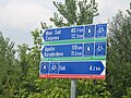
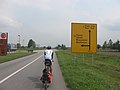
The road is part of the Euro Velo -Route Atlantic - Black Sea (EV6) and part of the D-Route D6 ( Danube route from Basel to Passau). The Upper Austrian part of the Danube Cycle Path is signposted with R1 Donauweg , the Lower Austrian part with R6 Danube Cycle Path . While the section in the upper reaches from the source to Budapest and in the Serbian section is continuously signposted, there are no corresponding markings, especially in the Bulgarian and Romanian sections. Here, the cycle path mostly runs on more or less quiet country roads and the cyclist is dependent on appropriate maps.
Germany
The Danube route D6 begins in front of the source of the Danube in the triangle near Basel, from Donaueschingen it is the actual Danube Cycle Path , and from Tuttlingen downstream also the river route EV6 .
- In Baden-Wurttemberg: Donaueschingen ↔ Tuttlingen ↔ Beuron ↔ Sigmaringen ↔ Scheer ↔ Riedlingen ↔ Obermarchtal ↔ Ehingen ↔ Ulm
- In Bavaria: Neu-Ulm ↔ Oberelchingen ↔ Leipheim ↔ Günzburg ↔ Offingen ↔ Gundelfingen an der Donau ↔ Lauingen (Danube) ↔ Dillingen an der Donau ↔ Höchstädt an der Donau ↔ Donauwörth ↔ Marxheim ↔ Bertoldsheim ↔ Neuburg an der Donau ↔ Ingolstadt ↔ Neustadt an der Donau ↔ Weltenburg Monastery ↔ Kelheim ↔ Bad Abbach ↔ Regensburg ↔ Donaustauf ↔ Wörth an der Donau ↔ Kößnach ↔ Straubing ↔ Bogen ↔ Mariaposching ↔ Metten ↔ Deggendorf ↔ Niederalteich ↔ Osterhofen ↔ Pleinting ↔ Vilshofen ↔ Windorf ↔ Gaishofen ↔ Passau ↔ Obernzell
Baden-Württemberg section
From the source of the Danube in Donaueschingen , the approximately 600 kilometer long German Danube Cycle Path leads through the Baar to Tuttlingen and on through the Upper Danube Nature Park . The cycle path follows an over long distances the Black Forest railway , the railway-Tuttlingen Inzigkofen (except in the region of the four rail tunnel) and the railroad track Ulm-Sigmaringen . This offers the possibility of combined tours by train and bike .

The section in the Upper Danube Valley (between the Danube towns of Mühlheim an der Donau and Scheer ), the actual core of the Upper Danube Nature Park , is lined with a large number of mighty limestone cliffs as well as numerous castles, caves, palaces, ruins, monasteries and baroque churches, such as the Example:


.jpg)
- Castle of the Lords of Enzberg in Mühlheim
- Kallenberg castle ruins
- Bronnen Castle
- Button maker rock
- Benedictine monastery of Beuron
- Petershöhle
- Benedictus Cave
- Wildenstein Castle
- Werenwag Castle
- Falkenstein castle ruins
- Dietfurt ruins
- Neugutenstein castle ruins
- Amalienfelsen
- Hohenzollern Castle in Sigmaringen
- Scheer Castle
- Bartelstein Castle
- Baroque church in the residential town of Scheer
After Scheer, the Danube leaves the Swabian Alb and the Danube Cycle Path runs through the broad plains of the Upper Swabian Danube Valley. Via Riedlingen , Obermarchtal and Ehingen the cyclist reaches Ulm (km 194.5) and then leaves the state of Baden-Württemberg in the direction of Bavaria .
A popular and also signposted variant from Ehingen is the route through the Blautal to the Blautopf with the towns of Schelklingen , Blaubeuren and Blaustein , which in Ulm leads back to the normal Danube Cycle Path. The valley of the Blau was formed by the original Danube. When the Swabian Alb rose in the course of the unfolding of the Alps, the original Danube initially dug deeper and deeper into the rock until it finally found a bed further south.

The scenic variant through the Blautal touches the Swabian Alb biosphere area , which was established by UNESCO in 2009 . The route follows a loop to the north, which results in 43.5 kilometers between Ehingen and Ulm; the more direct normal route via Erbach , however, is ten kilometers shorter.
Section through Bavaria
In the state of Bavaria, the Danube Cycle Path first traverses the landscape that is commonly known as Bavarian Swabia . The large nature reserve Swabian Donaumoos flanks the way over a long distance. The route to Donauwörth leads via Elchingen , Günzburg , Dillingen and Höchstädt . The Upper Bavaria region is reached in Ingolstadt (km 352). With the Weltenburg monastery , Kelheim and Regensburg (km 443) the cyclist arrives in Lower Bavaria and the Upper Palatinate. After Wörth an der Donau , Straubing , Plattling and Vilshofen an der Donau it goes to Passau (km 595.5). Below Passau, the Danube - and with it the Danube Cycle Path - crosses the border with Austria . Below Obernzell , an accessible barrage offers the possibility of connecting the border crossing with the Danube crossing.
Further connections to the national and long-distance cycle network
On the Danube Cycle Path, there are some connection and branching options to the other southern German cycle path network:
In Donaueschingen, the Heidelberg-Black Forest-Lake Constance cycle path leads from both Lake Constance and the Black Forest to the Danube cycle path. In Tuttlingen the Hohenzollern cycle path reaches the Danube cycle path and continues north to the Neckar, south to the Überlinger See . The Swabian Alb Cycle Path crosses in Sigmaringen and leads either south to Lake Constance or northwest over the Swabian Alb to Nördlingen .
Almost star-shaped, four long cycle paths branch off at the same time as Ulm and Neu-Ulm:
- the Alb-Neckar cycle path across the Swabian Alb
- the Hohenlohe-Ostalb-Weg over the Ostalb to Bavaria
- the Iller cycle path into the Allgäu
- the Danube-Bodensee cycle path through Upper Swabia
At Offingen the Kammeltal cycle path branches off to the south along the Kammel through the Swabian Baroque Corner ; The Mindeltal-Radweg starts in Gundremmingen as a river route, also heading south along the Mindel .
The section of the long-distance cycle path between Bad Gögging and Passau (216 km) in Bavaria is reminiscent of Roman times, meets the Upper German-Raetian Limes in front of Regensburg and is called Via Danubia in Latin . It is signposted as such.
- In Donauwörth there is a connection to the Via Claudia Augusta (bike path as well as ancient Roman road )
- in Neustadt an der Donau there is a branch to the Hallertau hop tour .
- In Kelheim, the Danube Cycle Path connects with the Altmühltal Cycle Path . There too, as from Ehingen, you can explore a section of the Urdonau .
- The German Limes Cycle Path and the Five Rivers Cycle Path also join the Danube in Kelheim .
- In Deggendorf, the Isar cycle path joins the Danube cycle path.
- In Passau, the Tauern cycle path and the Inn cycle path lead to the Danube cycle path.
Austria

history
The emergence of cycle tourism along the Danube can be traced back to the first half of the 1980s. At the end of the 1970s, classic recreational holidays declined, tourists were increasingly arriving by motorized vehicles and the Upper Austrian Danube valley can be used as an example of this turning point in tourism.
In the 1980s, cycling holidays became increasingly popular. Paths, so-called treppel and towpaths , which were once used for freight ship trains, have been expanded, signage measures have been implemented and sections of the route have been expanded. Thus began the era of cycle tourism on the Danube. The father of the Danube Cycle Path is the journalist Paul Pollack. In the early 1980s he published a series of articles in the daily newspaper Kurier in which he propagated the long-distance cycle path Passau – Vienna under the term “Danube Cycle Path”. Against the resistance of the authority (at that time the Federal Electricity Construction Office), he enforced that the driving ban on the stairwells that had been in effect until then was lifted by an amendment to the Waterways Act. Pollack has subsequently written several guides on the Danube Cycle Path.
In 1984 the then managing director of the Mühlviertel tourist region, Manfred Traunmüller, published the first guide to the Danube Cycle Path. The first bookable bike tours were organized at this time.
In 1991, the Donau Oberösterreich advertising association was founded to promote regional development and develop joint marketing measures. Today 42 communities are members of the association. These include Linz , Passau and St. Nikola on the Danube .
In 2010, bike counts were carried out at 17 locations on the Danube Cycle Path in combination with another guest survey. The results show that 437,000 cyclists use the Austrian Danube Cycle Path, of which 33 percent are holidaymakers, 33 percent are day trippers and 34 percent are everyday cyclists. Austria's annual economic successes, which according to the study are initiated by bicycle travelers, amount to 71.8 million euros.
The Danube Cycle Path is constantly being developed and optimized. In 2014, the section between Wesenufer and Schlögen was completed to ensure an even denser network of paths.
course


The section from Passau to Vienna is the second busiest cycle route in Europe after the Lake Constance cycle path. Every year around 630,000 cyclists are out and about on the Austrian Danube Cycle Path, of which around 55,000 cover the entire 326 kilometers. The cycle travel analyzes of the ADFC , which has also been carrying out censuses on the Austrian section since 2010, show a significant increase in the number of cyclists compared to previous years. The route is appealing because of its diverse landscape and culture and because the three to seven daily stages (depending on fitness) have a good infrastructure. Along the route you will find the free e-bike charging stations built in 2011, as well as numerous bike -friendly businesses. The further course of the cycle path from Vienna towards Hungary (about 70 km) leads past the Donauauen National Park and is a little less busy.
From Passau ( 313 m above sea level ) downstream, you can choose the route to the right (south) or left (north) of the Danube. On the southern route, a detour to Schardenberg (600 m) is recommended , whose observation tower offers a wide panoramic view of the Alpine foothills . In front of the border station at Obernzell is the 800 year old Krempelstein Castle , the former seat of the Rosicrucians. This is followed by Vichtenstein Castle near Kasten and you pass the Jochenstein Danube power plant , which was jointly built by German and Austrian power plant operators in 1952–56. After the robber knight's castle Rannariedl and the village of Niederranna , the cycle path runs past the Ameisberg with its holiday park, on the Mühlviertel Donauland , through the Schlögener loop to the Eferdinger basin . The Wilhering is located in front of the narrow stream at Kürnberger forest .
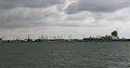
Then you get to the Upper Austrian capital Linz ( European Capital of Culture 2009 ) with its three Danube bridges. The Lentos Art Museum , the Ars Electronica Center opposite , the Brucknerhaus , the tobacco factory and the nearby old town with its promenade and cathedral are lined up along the newly designed bank area . This Linz urban space on the Danube is characterized by an “open-air ensemble of modern art”. a. Includes artwork by David Rabinowitch , Mathias Goeritz, and Herbert Bayer . Attention: The Linz railway bridge is constantly being demolished in 2016. On the further journey, the route on the left bank of the flood dam offers a good view of the Linz Danube Bend, the industrial area of VÖEST and the pilgrimage church on the Pöstlingberg .
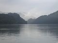
The following section invites you to visit Mauthausen ( Mauthausen concentration camp , granite quarries), the Roman town of Lauriacum and the town of Enns - high above the mouth of the river of the same name. After the fertile Machland with the Celtic village Mitterkirchen , the Ardagger Abbey follows . The city of Grein has two very important tourist attractions: the Grein City Theater (Austria's oldest city theater that can still be played today) and the stately home of Greinburg Castle with its magnificent interior and the Upper Austrian Maritime Museum . This part of the route is passable by bike on both sides along the Danube. The southern bank of the Danube is also known as the Mostviertel Danube Cycle Path .
This is where Strudengau , which used to be very dangerous, begins with the main town of St. Nikola an der Donau , where people used to bring their own pilots onto the ships. Today the area belongs to the storage area of the following power plant and is easily accessible for shipping. The castles Werfenstein and Freyenstein are located at the beginning of a straight stretch of river where the Waldviertel Yspertal flows from the north . This is also known as the valley of the sundials known . In the loop of the river at Persenbeug and Ybbs , which should also be viewed from above (southern river terrace ), Austria's largest run-of- river power plant , the Ybbs-Persenbeug power plant , was built in the 1950s .
After Pöchlarn (Bechelaren in the Nibelungen saga ), not far from the Ostarrichi memorial from 996, one arrives at the Benedictine Melk Abbey, visible from afar, with its two towers, the baroque library and the abbey garden. From Melk, cycle paths lead on both sides of the Danube into the breakthrough valley of the Wachau (wine and fruit growing, medieval churches, Aggsbach Charterhouse , Aggstein ruins , Schiffermuseum, Dürnstein ). The Wachau ends at the Lower Austrian town of Krems , which is equipped with a number of exhibitions, museums and fortifications. Wine and nature lovers should in the neighboring Langenlois the Loisium visit and the imposing, from loess shaped terraces climb -Landscape.
After the monastery mountain of Göttweig Abbey and the castle hills near Hollenburg , you pass further power stations and reach the flat land of the Tullner Feld , at the beginning of which is the very old settlement of Traismauer (the Roman Augustianis ). To the south of the Danube are rural road villages, to the north the Danube floodplains begin with numerous oxbow lakes. The cycle path leads across the grounds of the Zwentendorf nuclear power plant, which never went into operation . In Tulln (two bridges over the Danube, Old Town) is the Vienna Woods in sight, at the foot of the castle Greifenstein and Babenberger - Stift Klosterneuburg are. Through the Wiener Pforte on the steep slope of the Leopoldsberg one comes to Vienna and drives on the Danube Island , an elongated island built as flood protection , which serves as an event and recreation area as well as a nature reserve.
The Danube Cycle Path crosses the Vienna Basin and you can visit one of the many Marchfeld castles and the center of the Donau-Auen National Park near Orth . The Roman city of Carnuntum near Petronell is located on the river terrace on the south bank with several excavation sites and the Heidentor . From a distance you can see the Hainburg Mountains approaching in the east , where the Carpathian Mountains begin, and you reach the city of Hainburg with the Vienna and Hungarian gates. On the outskirts, the route leads past the Schlossberg and Braunsberg ( Celtic excavations) and the Thebner Kogel to the Hungarian Gate - the transition to the Hungarian Plain . Right after the Austrian-Slovak border, where the March flows into the Danube, is Bratislava , the capital of Slovakia.
Strudengau

Ybbs, view through the old city gate

Passage through Krems-Stein

Vienna, district heating plant painted by Friedensreich Hundertwasser

Meadow landscape near Vienna

Danube Cycle Path in Hainburg an der Donau


Slovakia and Hungary

From Bratislava it goes on the Slovak side through the Little Hungarian Plain over the dams of the dammed Danube to the Gabčíkovo hydroelectric power station and from there partly on gravel roads to Komárno . The alternative route, on the Hungarian side to Komárom , usually moves a few kilometers away from the Danube, but offers the opportunity to visit the cities of Mosonmagyaróvár and Győr . From the twin towns of Komárom / Komárno you can choose to go on the Slovak or Hungarian side to Esztergom , with the Hungarian side leading over the Hungarian low mountain range. At the Danube Bend near Esztergom, the path bends south and leads via Szentendre to Budapest .
The route from Budapest leads to the Danube island of Csepel . As far as Baja, it is mostly away from traffic over flood dams on partly unpaved roads. There are two alternative routes from Baja. One leads directly to the Serbian border, then via Sombor to Novi Sad. The other first leads to the small town of Mohács , which is known for the battles of 1526 and 1687 against the Ottoman Empire. A ferry takes you there on the right side of the Danube towards the Croatian border.
Criticisms
In general, it can be said that parts of the route in Hungary hardly meet the requirements of an international cycle path. Gravel and sand paths (partly between Györ and Komarom) make the tour no fun there. From Esztergom to the Danube ferry to Szob, the first 5 km along the Danube are on a (rather narrow) paved path away from the road; However, the next 5 km are on the fairly busy road number 11. Special problems arise from the fact that the majority of Hungarian drivers consider a minimum distance of 50 cm to cyclists to be sufficient.

Bratislava, Michaelertor

Encounter on the Slovakian Danube
Dammed Danube and power station near Gabčíkovo

Gravel road and railway bridge at Révkomárom / Komarno

Esztergom

Evening mood at Szentendre

Budapest, view from Gellért Hill

Pedestrian zone in Mohács


.JPG)
Croatia

The route is not fully signposted in Croatia as Ruta Dunav . The route initially leads through smaller villages to Zmajevac, which is mainly inhabited by Hungarians. From here you can either continue on the road to Osijek or, just before entering the village, turn onto a gravel road that leads through the Kopački rit Nature Park and ends on the road a few kilometers before Osijek . From Osijek it goes on country roads to Vukovar . Many buildings here still remind of the destruction of the city during the Battle of Vukovar in the Croatian War . The last city in Croatia is Ilok . From there there are two border crossings to Serbia, from where you can get to Novi Sad either on the right or left bank of the river.
In the Croatian section you come across many signs on the wayside warning of land mines. There you should absolutely avoid leaving the streets or paths. The Croatian mine clearance center offers maps and further information.
Serbia

Under the leadership of the German Society for Technical Cooperation (GTZ), an integrated concept to promote bicycle tourism in Serbia was developed between 2006 and 2009 , which is supplemented by extensive online and print documentation. As a result, the route in Serbia is completely signposted and partly with alternative routes. Most of the time, the route runs on quiet back roads that are not always asphalted. Only in the major cities of Novi Sad and Belgrade are there separate cycle path tours.
The route from Hungary directly to Serbia leads via Sombor and Bogojevo to Bačka Palanka . From there it goes on the left side of the Danube to Novi Sad , the capital of the province of Vojvodina . Along the waterfront, the Danube Cycle Path leads past the city center and then over a bridge to the Petrovaradin fortress . Alternatively, there is a second border crossing to Serbia at Ilok , from where you can continue on the right bank of the river. Between the Danube and the small mountain range Fruška Gora , which is known as a nature reserve and has numerous Orthodox monasteries, this variant leads to Novi Sad with more gradients but less traffic.
From Novi Sad, the route first leads south on the main road, then on less traveled country roads through smaller villages. From Batajnica it goes back to the main road. This leads to the Belgrade district of Zemun , where you can continue on cycle paths along the shore. When you arrive at the mouth of the Sava , you can see Kalemegdan on the other side with the remains of the Belgrade fortress . Not far upstream from the mouth, the Brankov most bridge leads over the Sava into the old town of Belgrade. There is an elevator on this side that also takes bikes from the bridge to a bike path along the shore.
Belgrade is left over the Pančevo Bridge , from where the route continues to Ram on the Serbian-Romanian border on the left bank of the Danube. This leads either on unpaved roads or (from Pančevo ) on roads with little traffic. A detour to Smederevo is signposted at Kovin . At Ram, a ferry takes you back to the right bank of the river. From here the Danube forms the border between Serbia and Romania. From Golubac it goes through the Iron Gate , the imposing breakthrough valley of the Danube through the southern Carpathians . From Veliko Gradište there are only a few smaller villages. Here you have to overcome some height differences of up to 200 meters and cross some tunnels. Important sights in this section are the statue of Decebalus on the Romanian side, the Tabula Traiana , which can only be seen from the ship, and the archaeological site of Lepenski Vir . On the east side of the mountain, you can cross the Danube and thus the border to Romania via the dam of the Eisernes Tor I power station near Drobeta Turnu Severin . On the Serbian side, the Danube Cycle Path continues via Negotin to Bulgaria.

Course of the Danube Cycle Path in Serbia, taken in Novi Sad
Signs for the Danube Cycle Path shortly after the Croatian-Serbian border
In Serbia, the Danube Cycle Path partly runs along the main roads


Bulgaria
Over a length of around 500 kilometers, the Danube forms the common border between Bulgaria and Romania. Here, the Danube Cycle Path is planned on both sides, i.e. in both countries, or in the course of implementation. In the summer of 2010, signs for the Bulgarian part of the route ( Bulgarian Дунавският веломаршрут ) began on the Serbian-Bulgarian border near Vidin . From Vidin it should continue via Lom , Orjachowo , Swishtov , Russe to Silistra , from where the Danube flows entirely on Romanian territory. The marking work was completed in 2012.
Romania

With a length of over 1000 kilometers, Romania has the longest section of any single country along the Danube Cycle Route. The route runs along the border with Bulgaria through the areas of Little and Great Wallachia to the east and then through the Dobruja first in a northerly direction and then to the Danube Delta.
Coming from the dam of the Eisernes Tor I power plant , after a few kilometers you will reach the town of Drobeta Turnu Severin . From here, the route leads always near the Danube through countless villages and smaller towns such as Calafat , Corabia , Turnu Măgurele , Zimnicea and Giurgiu . Giurgiu is connected to the Bulgarian city of Ruse by the Friendship Bridge . Until the opening of the second Danube Bridge “New Europe” in late summer 2013, this was the only bridge between Bulgaria and Romania across the Danube. The route continues via Oltenița to Călărași . From there you can take a ferry to the other side of the Danube and drive past the Bulgarian town of Silistra . The route now runs on the right side of the Danube to Cernavodă , where the Danube-Black Sea Canal branches off from the Danube, and finally via Hârșova and Măcin to Tulcea . From here the Danube forms an extensive delta which, as an important biosphere reserve, is a UNESCO World Heritage Site . The official odometer counting of the Danube begins at Sulina . This town is not connected to the road network but can be reached by ferry from Tulcea.
See also
Literature and maps
- Cycling map of the Danube cycle path 1 Donaueschingen – Passau. 1: 50,000. Publicpress-Verlag, ISBN 978-3-89920-235-9 .
- Cycling map of the Danube cycle path 2 Passau – Vienna. 1: 50,000. Publicpress-Verlag, ISBN 978-3-89920-246-5 .
- bikeline bike tour book “Danube Cycle Path Part 1: German Danube - From Donaueschingen to Passau” . Esterbauer, A-Rodingersdorf 2013, ISBN 978-3-85000-422-0 .
- bikeline bike tour book “Danube Cycle Path Part 2: From Passau to Vienna” . Esterbauer, A-Rodingersdorf 2011, ISBN 978-3-85000-024-6 .
- bikeline bike tour book “Danube Cycle Path Part 3: Slovak and Hungarian Danube. From Vienna to Budapest. ” Esterbauer, A-Rodingersdorf 2011, ISBN 978-3-85000-078-9 .
- bikeline bike tour book “Danube Cycle Path Part 4: Hungary, Croatia, Serbia. From Budapest to Belgrade: 570 km. “ Esterbauer, A-Rodingersdorf 2013, ISBN 978-3-85000-424-4 .
- bikeline bike tour book "Danube Cycle Path Part 5: Serbia, Romania, Bulgaria: From Belgrade to the Black Sea." Esterbauer, A-Rodingersdorf 2013, ISBN 978-3-85000-446-6 .
- Bicycle tour book Danube cycle path 2 From Passau to Vienna. 1: 50,000. Verlag Esterbauer, 2011, ISBN 978-3-85000-024-6 .
- Bicycle tour book Danube cycle path 3 From Vienna to Budapest. 1: 75,000. Verlag Esterbauer, 2009, ISBN 978-3-85000-078-9 .
- Bicycle tour book Danube cycle path 4 From Budapest to Belgrade. 1: 75,000. Verlag Esterbauer, 2010, ISBN 978-3-85000-295-0 .
- Radourenbuch Donau-Radweg 5 From Belgrade to the Black Sea. 1: 100,000. Verlag Esterbauer, 2010, ISBN 978-3-85000-282-0 .
- Danube Cycle Guide, From Passau to Vienna. ISBN 3-931944-52-2 .
- Bernhard Irlinger: The Danube Cycle Path, From the Source to Passau. ISBN 3-7654-3388-8 .
- Michael Reimer, Wolfgang Taschner: Danube Cycle Path, Passau-Vienna-Budapest. ISBN 3-7654-3630-5 .
- GTZ / Kartographie Huber: Danube Cycle Route from Budapest to the Black Sea. 1: 100,000. ISBN 3-936990-30-1 .
- Danube Cycle Path - from Passau to Vienna . Compact Spiralo 1: 75,000, BVA Bielefelder Verlagsanstalt, ISBN 978-3-87073-458-9
- Danube Cycle Path - Germany . ADFC -Kompakt-Spiralo 1: 75,000, BVA Bielefelder Verlagsanstalt, ISBN 978-3-87073-645-3
Web links
Individual evidence
- ↑ - Danube Cycle Path - information and tour tips at www.eurobike.at, accessed on June 19, 2019
- ↑ ADFC quality cycle routes with 4 stars on www.adfc.de, accessed on August 24, 2018
- ^ General German Bicycle Club eV: The ADFC Travelbike Radreiseanalyse 2018 . ( adfc.de [accessed on August 16, 2018]).
- ↑ Deutsche Donau Cycle Route at www.deutsche-donau.de, accessed on August 24, 2018
- ↑ Miglbauer, Ernst, “The classic: 25 years of the Danube Cycle Path”, Cycle Tourism: Developments, Potentials, Perspectives , Ed. Axel Dreyer u. a., Munich: Oldenbourg Wissenschaftsverlag 2012, pp. 183–191.
- ↑ GEO season No. 6/2016, Upper Austria, p. 9.
- ↑ Traunmüller, Manfred, Meine Radfahrt an der Donau: A guide to the cycle paths on the Upper Austrian Danube and the adjacent area , Linz: OLV 1984.
- ↑ Mitterlehner, New Tourism Strategy Supporting Danube Tourism , press release, Vienna: BMWFJ - Federal Ministry for Economy, Family and Youth, February 21, 2011.
- ^ Press release from the Province of Upper Austria on April 9, 2014.
- ↑ The ADFC bicycle travel analysis 2013 - figures, data and facts. Retrieved April 8, 2019 . . ADFC website. Retrieved November 29, 2013.
- ↑ Danube Cycle Path - fully on course! Retrieved August 24, 2018 .
- ↑ forum metal . Website of the city of Linz. Retrieved December 9, 2013.
- ↑ Croatian Mine Clearance Center: Mine situation in the Osijek-Baranja County in January 2009, accessed on March 13, 2009 ( Memento of the original from April 3, 2011 in the Internet Archive ) Info: The archive link has been inserted automatically and has not yet been checked. Please check the original and archive link according to the instructions and then remove this notice.
- ↑ Маркират дунавския веломаршрут. ( Marking of the Danube Cycle Path . ) Www.vestnikstroitel.bg, August 6, 2010
Footnotes
- ^ After Ister , the name common in antiquity for the lower course of the Danube
Coordinates: 48 ° 24 ′ 3 ″ N , 9 ° 59 ′ 14 ″ E

North Sea Coast Route (D1) | Baltic Sea Coast Route (D2) | European route (D3) | Mittelland Route (D4) | Saar-Mosel-Main (D5) | Danube route (D6) | Pilgrim route (D7) | Rhine Route (D8) | Weser - Romantic Road (D9) | Elbe Cycle Path (D10) | Baltic Sea – Upper Bavaria (D11) | Oder-Neisse cycle path (D12)