Gokels
| coat of arms | Germany map | |
|---|---|---|

|
Coordinates: 54 ° 7 ' N , 9 ° 28' E |
|
| Basic data | ||
| State : | Schleswig-Holstein | |
| Circle : | Rendsburg-Eckernförde | |
| Office : | Mittelholstein | |
| Height : | 10 m above sea level NHN | |
| Area : | 10.64 km 2 | |
| Residents: | 545 (Dec. 31, 2019) | |
| Population density : | 51 inhabitants per km 2 | |
| Postal code : | 25557 | |
| Area code : | 04872 | |
| License plate : | RD, ECK | |
| Community key : | 01 0 58 061 | |
| Office administration address: | Am Markt 15 24594 Hohenwestedt |
|
| Website : | ||
| Mayor : | Heiko Hadenfeldt (AWG) | |
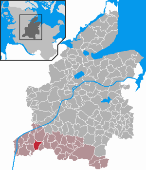
| Location of the community of Gokels in the Rendsburg-Eckernförde district | ||
Gokels is a municipality in the Rendsburg-Eckernförde district in Schleswig-Holstein . Ohrsee and Klein-Hamburg are located in the municipality that has existed in its current form since 1938.
Geography and traffic
Gokels is located about 22 km southeast of Heide in a rural setting. The lowlands are protected landscape areas.
The Kiel Canal runs north of Gokels, and federal motorway 23 from Hamburg to Heide to the west . The place is also on the Neumünster – Heide railway line . In passenger transport, the Gokels stop is served every two hours.
history
Numerous barrows in the municipality testify to prehistoric settlement .
Ohrsee was first mentioned in a document in 1281.
politics
Community representation
Of the nine seats in the municipal council, the WGG electoral community has had all seats since the local elections in May 2013.
coat of arms
Blazon : “ Divided by green and red by a silver wavy bar covered with three black stones according to the figure . Above a silver stone grave consisting of two bearing stones and a capstone , below a three-legged golden groats pot with an upright handle. "
economy
In the originally agricultural community, residential use predominates today.
Web links
Individual evidence
- ↑ North Statistics Office - Population of the municipalities in Schleswig-Holstein 4th quarter 2019 (XLSX file) (update based on the 2011 census) ( help on this ).
- ↑ Schleswig-Holstein topography . 1st edition. tape 3 : Ellerbek - Groß Rönnau . Flying-Kiwi-Verlag Junge, Flensburg 2003, ISBN 978-3-926055-73-6 , p. 253 .
- ↑ Results of the local elections 2013 . amt-mittelholstein.de. Retrieved May 27, 2013.
- ↑ Schleswig-Holstein's municipal coat of arms

