
Fullraths rest
| coat of arms | Germany map | |
|---|---|---|

|
Coordinates: 53 ° 39 ′ N , 12 ° 29 ′ E |
|
| Basic data | ||
| State : | Mecklenburg-Western Pomerania | |
| County : | Mecklenburg Lake District | |
| Office : | Lake landscape goods | |
| Height : | 70 m above sea level NHN | |
| Area : | 31.24 km 2 | |
| Residents: | 392 (Dec. 31, 2019) | |
| Population density : | 13 inhabitants per km 2 | |
| Postal code : | 17194 | |
| Area code : | 039933 | |
| License plate : | MSE, AT, DM, MC, MST, MÜR, NZ, RM, WRN | |
| Community key : | 13 0 71 154 | |
| Office administration address: | Friedensstrasse 11 17192 Waren (Müritz) |
|
| Website : | ||
| Mayor : | Sabine Junge | |
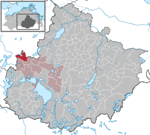
| Location of the community Vollrathsruhe in the Mecklenburg Lake District | ||
  |
||

Vollrathsruhe is a municipality in the northwest of the Mecklenburg Lake District . The Mecklenburg community is administered by the Lake Landscape Department in Waren , based in Waren (Müritz) .
geography
The municipality Vollrathsruhe on the southern edge of Mecklenburg Switzerland is located in the Mecklenburg Lake District , between Malchiner and Krakower See . The town of Teterow is about 15 km from Vollrathsruhe. The hilly municipal area (up to 102 m above sea level) is rich in forests and lakes. The Westpeene , the shortest but hydrographically highest-ranking source river of the Peene, rises north of the district of Kirch Grubenhagen near the municipal boundary . Shortly after its source, the Westpeene forms the border between Vollrathsruhe and the municipality of Dahmen in the Rostock district for more than four kilometers . The districts of Klein-Luckow, Groß Rehberg, Kirch and Grubenhagen Castle are located in the Mecklenburg Switzerland and Kummerower See nature reserve .
Districts
The districts belong to Vollrathsruhe:
- Great Rehberg
- Hallalit
- Church of Grubenhagen
- Little Luckow
- Klein Rehberg
- Grubenhagen Castle

history
The community Vollrathsruhe was created on July 1, 1950 through the merger of the previously independent communities Groß Rehberg, Kirch Grubenhagen and Schloß Grubenhagen.
Hallalit

Hallalit has nearby barrows , the colonization in the bronze time occupy. The place name could come from the hunter language. Dat Lange Hus , a 104 m long cottage made of field stones, dates from the middle of the 19th century.
Church of Grubenhagen
The Romanesque stone church dates from the first half of the 13th century.
Little Luckow
Lucowe was first mentioned in a document in 1316 in the land partition contract. The manor house built in 1756 - a half-timbered building - and the second manor house from after 1880, a two-storey, ten-axis plastered building owned by Otto von Müller, have not existed since 1974 and 1977 respectively.
Fullraths rest

In 1759 Vollrath Levin II von Maltzahn received the parish lease from Kirch-Grubenhagen on a long lease. The estate was then owned by the Heise-Rothenburg families (from 1828), Karl von Maltzahn (from 1851) and Tiele-Winckler (1876–1945). After a fire in 1917, the neo-baroque palace was rebuilt. The octagonal castle chapel (mausoleum) dates from the 19th century. During the German Democratic Republic, Vollrathsruhe was the seat of a youth work center for children who were difficult to raise.
Grubenhagen
was named after the von Grube family (vassals of the princes of Werle ) who had lived here since the 13th century. They had the castle complex built with a 10 meter high keep of the main castle, which has been preserved as the Grubenhagen castle ruins . The castle was owned by the Maltzan family in 1364 , who held the estate until 1945. The manor house by the castle ruins was built around 1840. After 1991 it was bought back and renovated by a branch of the Maltzan family.
politics
Coat of arms, flag, official seal
The municipality has no officially approved national emblem, neither a coat of arms nor a flag. The official seal is the small state seal with the coat of arms of the state of Mecklenburg. It shows a looking bull's head with torn off neck fur and crown and the inscription "GEMEINDE VOLLRATHSRUHE • LANDKREIS MECKLENBURGISCHE SEENPLATTE".
Attractions
District Kirch Grubenhagen:
- Village church church Grubenhagen ; on the outside a field stone building from the 13th century, heavily changed in 1861 through extensive renovations and additions.
- Former inn with medium risk (Teterower Str. 3)
Grubenhagen Castle district:
- Ruins of Grubenhagen Castle from the 13th century
- Gutshaus Schloss Grubenhagen north of the castle ruins
Vollrathsruhe district:
- Vollrathsruhe manor complex with two-storey, 13-axis manor house, park and mausoleum
District Hallalit:
- Dat Lange Hus , a 104 m long farm workers' house. It is the longest fieldstone house in the region and was built for 16 families in the mid-19th century.
Klein Luckow district:
- Nature reserve Desert and Glass in with a Bronze Age and / or Slavic rampart.
Klein Rehberg district:

Church in Kirch Grubenhagen

Teterower Str. 3 in Kirch Grubenhagen

Vollrathsruhe Castle (2014)
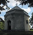
Chapel in Vollrathsruhe Castle Park

Ruin of the stables of Vollrathsruhe Castle


Personalities
- Dietrich Friedrich von Holstein (1758–1840), Mecklenburg colonel and city commander of Güstrow
- Karl Freiherr von Maltzahn (1797-1868), Prussian Oberland equerry , Landstallmeister the Mecklenburg State Stud Redefin , co-founder of the flat racing and thoroughbred breeding in Germany
traffic
Vollrathsruhe is on the road from Malchow to Teterow or Malchin . The nearby federal highway 108 leads to the town of Waren (Müritz), approx. 20 km away. The Linstow junction is nine kilometers away on the A 19 ( Rostock - Berlin ).
The platforms of the Vollrathsruhe station were dismantled as part of the upgrading of the Berlin - Rostock line that crosses the community. The next train stations on this route are in Langhagen (northwest, approx. 6 km) and Waren (Müritz) (southeast, approx. 20 km). In Silz , the Nossentin stop, approx. 14 km south-west, can be reached on the Parchim – Neubrandenburg railway line, and the Bützow – Szczecin railway line in Teterow , approx. 15 km north-east .
Web links
- www.gutshaeuser.de about the manor house in Vollrathsruhe
- Manor house in the district of Grubenhagen Castle
Individual evidence
- ↑ Statistisches Amt MV - population status of the districts, offices and municipalities 2019 (XLS file) (official population figures in the update of the 2011 census) ( help ).
- ↑ Main Statute, Section 2, Paragraph 1
Alt Schwerin | Altenhagen | Altenhof | Altentreptow | Ankershagen | Bartow | Basedow | Beggerow | Ownership | Blankenhof | Blankensee | Flower wood | Bollewick | Borrentine | Bredenfelde | Breesen | Breest | Briggow | Brunn | Buchholz | Stargard Castle | Burow | Bütow | Carpin | Cölpin | Dargun | Datzetal | Demmin | Eldetal | Rotten rust | Feldberger Seenlandschaft | Fincken | Friedland | Five lakes | Galenbeck | Gielow | Gnevkow | Godendorf | Goehren-Lebbin | Golchen | Gotthun | Grabowhöfe | Grammentin | Grapzow | Grischow | Large trowel | Groß Miltzow | Gross Nemerow | Large plastic | Groß Teetzleben | Grünow | Validity | Gülzow | High Wangelin | Hohenbollentin | Hohenmocker | Hohenzieritz | Holldorf | Ivenack | Jabel | Jürgenstorf | Kargow | Kentzlin | Kieve | Kittendorf | Little Thank You | Kletzin | Klink | Klocksin | Knorrendorf | Kratzeburg | Kriesow | Sublank | Kuckssee | Kummerow | Larz | Leizen | Lindenberg | Lindetal | Malchin | Malchow | Meesiger | Melz | Mirow | Möllenbeck | Möllenhagen | Mölln | Moltzow | Neddemin | Neetzka | Neubrandenburg | Neuenkirchen | Recalculation | Neustrelitz | Neverin | Nossendorf | Nossentiner Hut | Peenehagen | Penkow | Penzlin | Pragsdorf | Priborn | Priepert | Pripsleben | Rechlin | Ritzerow | Röbel / Müritz | Röckwitz | Rosenow | Sarov | Schloen-Dratow | Schönbeck | Schönfeld | Schönhausen | Black | Siedenbollentin | Siedenbrünzow | Sietow | Silz | Sommersdorf | Sponholz | Staven | Stavenhagen | Steer | Südmüritz | Torgelow am See | Trollenhagen | Tützpatz | Userin | Utzedel | Forgive | Voigtsdorf | Vollrathsruhe | Walow | Waren (Müritz) | Warrenzin | Werder | Wesenberg | Wildberg | Woggersin | Wokuhl-Dabelow | Wolde | Woldegk | Wulkenzin | Wustrow | Zettemin | Zirzow | Zislow