
District of Lindau (Lake Constance)
| coat of arms | Germany map |
|---|---|

|

Coordinates: 47 ° 36 ' N , 9 ° 52' E |
| Basic data | |
| State : | Bavaria |
| Administrative region : | Swabia |
| Administrative headquarters : | Lindau (Lake Constance) |
| Area : | 323.44 km 2 |
| Residents: | 81,981 (Dec. 31, 2019) |
| Population density : | 253 inhabitants per km 2 |
| License plate : | LI |
| Circle key : | 09 7 76 |
| NUTS : | DE27A |
| Circle structure: | 19 municipalities |
| Address of the district administration: |
Stiftsplatz 4 88131 Lindau (Lake Constance) |
| Website : | |
| District Administrator : | Elmar Stegmann ( CSU ) |
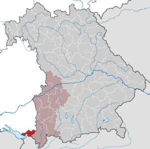
| Location of the district of Lindau (Lake Constance) in Bavaria | |
  |
|
.png)

The district of Lindau (Bodensee) is a district in the southwest of the Bavarian Swabia . The district has a natural border in the southwest on the shores of Lake Constance , on which the district town of Lindau is located.
geography
location
The district borders in the southwest on the banks of the Obersee , the eastern and deepest part of Lake Constance. The old town of the district town of Lindau is located on an island in the lake . To the west follow Bad Schachen (a district of Lindau), Bodolz , Wasserburg and Nonnenhorn . In addition to tourism, the riverside towns are also characterized by fishing and viticulture , which is mainly carried out in Nonnenhorn and on the Hoyerberg near Lindau. To the northeast, there is a hill country with terminal moraines and drumlins . The district is also part of the Western Allgäu . The ridge of the Pfänder extends in the north-northeast direction, the heights are usually about 700- 800 m above sea level. NN . To the east follow further mountain ridges running parallel to the Pfänderrücken. The district borders on the Austrian state of Vorarlberg and, through Lake Constance, on the Swiss cantons of St. Gallen and Thurgau .
In the district, 62.7 percent of the total area is used as agricultural land.
Neighboring areas
The district borders in a clockwise direction in the northwest with the Lake Constance district and the Ravensburg district (both in Baden-Württemberg ), the Oberallgäu district (in Bavaria ), and the Bregenz district (in Vorarlberg , Austria )
geology
Geologically, they are mainly characterized by the Tertiary Nagelfluh rocks.
climate
Due to the considerable height differences, there are clear climatic differences in the district: While the fruit trees are already in bloom on Lake Constance and temperatures above 25 ° C are reached, in the Westallgäu you can still find meter-high snow. On the Pfänderrücken there is incline rain, which is why the annual precipitation is highest there (well over 1,000 mm / a), while it is drier in the west and east (around 800 mm / a). The Westallgäu is characterized by an above-average duration of sunshine (up to 2,000 hours per year).
history
Until 1800
The district, like the rest of the Lake Constance area and Allgäu, was inhabited by the Celts in prehistoric times . Celtic refuges from this period still exist, but they have hardly been preserved. 15 BC The Romans conquered the area and incorporated it into the province of Raetia . There was a Roman shipyard in Lindau, but archaeological finds are rare in the district. From the 3rd century onwards there were increased incursions by Alemanni , who settled the area after the end of the Roman Empire. The Christianization took place in particular by St. Gallus and St. Magnus . The first documented mentions of early medieval settlements concern Haddinwilare, today's Laiblachsberg (between 769 and 773), Wasserburg (784), Lindenberg im Allgäu (857), Opfenbach (872), Weiler im Allgäu (894). The area was predominantly under the rule of the St. Gallen Monastery , parts of which belonged to the Mehrerau Monastery near Bregenz . Lindau developed most strongly , first mentioned in a document in 882, which rose to become a free imperial city in the 13th century and became particularly prosperous through trade. In the late Middle Ages, the rural areas passed into the rule of the House of Montfort , the Fuggers and the Habsburgs , who ruled over half of the district in the 18th century.
Regional courts
A reorganization took place through Napoleon Bonaparte . In 1802 Lindau lost imperial freedom (status as a Free Imperial City ), and in 1806 Bavaria was given the district area. The two regional courts of Lindau and Weiler were established, which initially belonged to the Illerkreis , from 1808 to the Oberdonaukreis (from 1838 Swabia and Neuburg, later only Swabia). The city of Lindau had left the regional court district in 1809 and became a city within the immediate district .
District Office
The district office of Lindau was formed in 1862 through the merger of the regional courts of the older order of Lindau and Weiler .
On February 1, 1922, the three communities of Aeschach , Hoyren and Reutin left the district office and were incorporated into the immediate city of Lindau.
- District officials
District before 1945
On January 1, 1939, the designation district was introduced as everywhere else in the German Reich . The district office became the Lindau district (Bodensee).
On April 1, 1940, the city of Lindau was incorporated into the district, but this was reversed on September 25, 1948.
District 1946 to 1956
After the Second World War , the area of the district was added to the French zone of occupation and administered together with Württemberg-Hohenzollern , while the rest of Bavaria was part of the American zone of occupation . The district thus had a special territorial position and belonged neither to Württemberg nor to Bavaria. The first and only head of administration was district president Anton Zwisler (1888–1977), a native of Bregenz, from 1946 to 1956.
The French military government had negotiated the special state structure with the American military government in order to obtain free access to the French occupation zone in Austria ( Vorarlberg ) as a land bridge after the French military government had ceded the Bavarian districts of Sonthofen and Kempten (Allgäu) to the American occupation zone.
The district of Lindau was with three delegates in the advisory state assembly of the state of Württemberg-Hohenzollern and together with the city of Lindau (Bodensee), which was spun off from the district on September 25, 1948, was also in the state parliament of the newly established state of Württemberg-Hohenzollern until December 19, 1950 represented.
There were a number of nicknames for the Land of Lindau, such as "Second Principality of Liechtenstein", "Paradise", "Germany's fat stain" or "Monte Carlo on Lake Constance". The latter name goes back to the casino opened in Lindau in 1950. The other names alluded to Lindau's financial self-sufficiency: the Lindau district was allowed to keep all taxes and duties to itself. While in other parts of Germany people were hungry in many places, Lindau had a surplus of fruit, meat and milk for export and a brisk construction activity.
District from 1956
The reclassification of the district to Bavaria took place on September 1, 1955. However, a transition period was negotiated and the construct formally ended on March 27, 1956 in a ceremony in the old town hall of Lindau in the presence of District President Anton Zwisler and the Bavarian Prime Minister Wilhelm Hoegner .
For historical reasons, some of the sports clubs in the Lindau district still play in Baden-Württemberg's leagues today .
On July 1, 1970, the Stiefenhofen community in the Sonthofen district was reclassified to the Lindau district (Lake Constance).
As part of the regional reform in Bavaria , the previously independent city of Lindau (Lake Constance) was incorporated into the district on July 1, 1972. The city of Lindau received the status of a large district town for the loss of district freedom .
Population development
The district of Lindau (Lake Constance) gained almost 10,000 inhabitants between 1988 and 2008 or grew by approx. 14%. Between 1988 and 2018 the district grew from 70,274 to 81,669 by 11,395 inhabitants or by 16.2%.
The following figures refer to the territorial status on May 25, 1987.
| year | 1840 | 1900 | 1939 | 1950 | 1961 | 1970 | 1987 | 1991 | 1995 | 2000 | 2005 | 2010 | 2015 |
| Residents | 27,543 | 36,275 | 47.141 | 59,304 | 64,442 | 68,803 | 69,522 | 74,458 | 75,796 | 77.106 | 79,467 | 79,769 | 80,429 |
Architectural monuments
See architectural monuments in the Lindau district (Lake Constance)
Protected areas
There are ten nature reserves , five landscape protection areas , eleven FFH areas and at least 18 geotopes designated by the Bavarian State Office for the Environment (as of August 2016) in the district.
See also:
- List of nature reserves in the Lindau district (Lake Constance)
- List of landscape protection areas in the district of Lindau (Lake Constance)
- List of FFH areas in the district of Lindau (Lake Constance)
- List of geotopes in the district of Lindau (Lake Constance)
politics
District council
The district council consists of 60 members who, according to the results of the local elections on March 15, 2020, are divided between the following parties and voter communities (with comparative figures from the 2014 election):
| Party / list | 2020 election | Election 2014 | |
|---|---|---|---|
| Seats | Seats | ||
| CSU | 20th | 24 | |
| GREEN | 13 | 9 | |
| SPD | 6th | 8th | |
| FDP | 2 | 1 | |
| ÖDP | 2 | 3 | |
| AfD | 2 | 0 | |
| The left | 1 | 0 | |
| Young Union (JU) | 3 | 0 | |
| Free voters (FW) | 8th | 11 | |
| Free Citizenship (FB) | 3 | 4th | |
| total | 60 | 60 |
District administrators
- 1965–1972: Fritz Fugmann (CSU)
- 1972–1996: Klaus Henninger (CSU)
- 1996–2002: Manfred Bernhardt (CSU)
- 2002–2008: Eduard Leifert (SPD)
- since May 1, 2008: Elmar Stegmann (CSU)
Elmar Stegmann was re-confirmed in office in the 2020 local elections with 92.5% of the valid votes.
coat of arms
The district of Lindau has the coat of arms described below and shown above:
- "Under the shield head with the Bavarian diamonds in silver above a blue wavy bar next to each other a green linden tree and a three-lipped red flag with gold fringes and three red rings."
-alt.png)
Until 1972, however, the coat of arms shown on the right was in effect:
- Split by red and silver; in front an upright silver hand, behind a triple lobed, golden fringed red flag; below two wavy beams split by silver and blue
economy
In the Future Atlas 2016 , the district of Lindau (Lake Constance) was ranked 25th out of 402 districts, municipal associations and independent cities in Germany, making it one of the regions with "very high future prospects".
Traditionally, fruit growing and viticulture dominate in the western part, while agriculture in the Western Allgäu is mainly characterized by cattle breeding and dairy farming. The tourism has gained in the last 100 years, ever more important. In the west, especially on Lake Constance , summer guests predominate, in the east ski tourism in winter and hiking and spa tourism in summer. Industrial centers are Lindau (including fruit juice production by Lindauer Bodensee-Fruchtsaft GmbH and mechanical engineering ) and Lindenberg (formerly the textile industry, especially (straw) hats; today characterized by Liebherr-Aerospace , the largest aerospace supplier in Germany).
In October 2018 the unemployment rate in the district was 2.2%.
traffic
Lake Constance shipping
In 1824 the first Lindau steamship , Max Joseph , was put into service, thus Lindau was connected to the shipping network, in 1835 the Lindau Steamboat AG was founded, which was later taken over by the Royal Bavarian State Railways. The district is directly connected to Austria, Switzerland and Baden-Württemberg through the Lake Constance ships.
Road traffic
The district is connected by highways with Munich and northern Germany as well as the western Lake Constance area and Austria .
railroad
The Lindau-Munich railway line , which for a long time formed the transport backbone of the district, was planned by the Bavarian State Railways from 1844 . In the course of this, the largest railway embankment in the world at that time was built near Röthenbach . The opening took place in 1853, so the district was connected to the Bavarian rail network, Bavaria was connected to the sea route to Switzerland. With the Lindau – Bludenz railway (1872), the district was also connected to Austria by rail. In 1874 the Lindau – Romanshorn railway line was set up. In the 1890s, a branch line to Wangen - Kißlegg was established in Hergatz together with the Württemberg State Railroad . Also Weiler im Allgäu was a branch line connected to the main line in 1897 in Röthenbach. This connection was financed by the community of Weiler itself (closed in 1960). It was not until 1899 that the Friedrichshafen – Lindau railway line closed the gap . In 1901, the Röthenbach-Lindenberg-Scheidegg local railway called Scheidegger Moosrutsche went into operation (closed in 1966).
Transport network
The Lindau district has been part of the Bodensee-Oberschwaben Verkehrsverbund (bodo) since 2017 . The area of this transport association also extends to the neighboring districts of Ravensburg and Bodenseekreis in Baden-Württemberg.
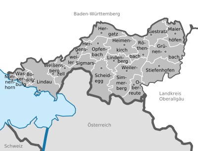
Communities
The district of Lindau is divided into 19 communities, of which 2 cities, 3 markets, 5 unitary communities and 3 administrative communities (with a total of 9 member communities).
(Residents on December 31, 2019)
|
Other communities
|
  |
Municipalities of the district before the territorial reform 1971/78
In the northeast the district bordered on the district of Kempten (Allgäu) , in the east on the district of Sonthofen , in the south on the Austrian state of Vorarlberg and the independent city of Lindau (Lake Constance) , in the west on the Baden-Württemberg district of Tettnang and in the north on the Also in Baden-Württemberg, the district of Wangen and the municipality of Achberg , which until 1969 belonged to the district of Sigmaringen , then to the district of Wangen.
The 28 communities in the Lindau district (Lake Constance) before the community reform in 1971/78. The churches that still exist today are in bold .

| former parish | today's parish |
|---|---|
| Bodolz | Bodolz |
| Evil reverence | Sigmarszell |
| Ebratshofen | Grünenbach |
| Ellhofen | Hamlet-Simmerberg |
| Gestratz | Gestratz |
| Grünenbach | Grünenbach |
| Harbatshofen | Stiefenhofen |
| Cherish | Wasserburg on Lake Constance |
| Heimenkirch (market) | Heimenkirch |
| Hergensweiler | Hergensweiler |
| Lindenberg im Allgäu (city) | Lindenberg in the Allgäu |
| Maierhöfen | Maierhöfen |
| Maria-Thann | Hergatz |
| Niederstaufen | Sigmarszell |
| Nun's horn | Nun's horn |
| Oberreitnau | Lindau (Lake Constance) |
| Oberreute | Oberreute |
| Opfenbach | Opfenbach |
| Röthenbach (Allgäu) | Röthenbach (Allgäu) |
| Scheffau | Scheidegg |
| Scheidegg (market) | Scheidegg |
| Sigmarszell | Sigmarszell |
| Simmerberg (market) | Hamlet-Simmerberg |
| Unterreitnau | Lindau (Lake Constance) |
| Wasserburg (Lake Constance) | Wasserburg (Lake Constance) |
| Hamlet in the Allgäu (market) | Hamlet-Simmerberg |
| Weißensberg | Weißensberg |
| Wohmbrechts | Hergatz |
The municipality of Mitten was renamed on March 23, 1926 in Wasserburg (Lake Constance) . The communities of Oberreitnau and Unterreitnau were merged on July 1, 1971 to form the Reitnau community, which in turn was incorporated into the city of Lindau on January 1, 1976.
License Plate
During the French occupation, the abbreviation X was used in the district for two years from 1947 . In 1948 the abbreviation FBy was introduced, which stood for "French Bavaria". The former was replaced in 1950 by the letters By . Until 1956 the abbreviations "FBy" and "By" were given for the district.
On July 1, 1956, the district and the independent city of Lindau (Lake Constance) were assigned the distinctive sign LI when the license plates that are still valid today were introduced . It is issued throughout the district to this day.
See also
- List of municipalities in the district of Lindau (Lake Constance)
- List of places in the district of Lindau (Bodensee)
literature
- Anton Gruber: The district of Lindau. Verlag des Heimatpflegers von Schwaben, Kempten (Allgäu) 1956, OCLC 36643898 .
- Heinrich Löffler: District of Lindau. Vol. 6, 1973; ISBN 3-7696-9889-4 .
- Günther U. Müller, Emil Kroher: Our district. Lindau, Lake Constance. District Office, Aichach 1969, OCLC 73901488 .
- Hugo Schnell: The district of Lindau. Landscape, history, art. 1982, ISBN 3-7954-0569-6 .
- At home in the Lindau district. 1994, ISBN 3-7977-0281-7 .
- Gerhard Willi (Hrsg.): Folklore and regional descriptions from the districts of Lindau and Oberallgäu with Kempten - the physics reports of the city and regional courts of Lindau, Weiler, Kempten, Immenstadt and Sonthofen (1858–1861). Augsburg 2016, ISBN 978-3-95786-036-1 .
Web links
- Homepage
- Westallgäu tourism website
- Literature from and about the district of Lindau in the catalog of the German National Library
- District of Lindau (Bodensee): Official statistics of the LfStat
Individual evidence
- ↑ "Data 2" sheet, Statistical Report A1200C 202041 Population of the municipalities, districts and administrative districts 1st quarter 2020 (population based on the 2011 census) ( help ).
- ^ District Administrator Elmar Stegmann. Lindau District Office (Bodensee), accessed on June 20, 2020 .
- ↑ Source: Statistics for the EUREGIO Lake Constance. In: Listed! The ten districts of the Lake Constance region… In: Südkurier from February 25, 2011 and in: Ders. dated July 2, 2011
- ^ Wilhelm Volkert (ed.): Handbook of Bavarian offices, communities and courts 1799–1980 . CH Beck, Munich 1983, ISBN 3-406-09669-7 , p. 512 .
- ↑ a b c territorial.de
- ^ Wilhelm Volkert (ed.): Handbook of Bavarian offices, communities and courts 1799–1980 . CH Beck, Munich 1983, ISBN 3-406-09669-7 , p. 97 .
- ↑ Süddeutsche Zeitung March 25, 2016 ("What power Zwisler had")
- ↑ Lindau district, result of the 2020 district council election , accessed on April 27, 2020
- ↑ Result of the district election 2020 in the Lindau district
- ↑ The coat of arms of the Lindau district (Lake Constance)
- ↑ https://www.hdbg.eu/gemeinden/index.php/detail?rschl=9776000
- ↑ Future Atlas 2016. (No longer available online.) Archived from the original on October 2, 2017 ; accessed on March 24, 2018 . Info: The archive link was inserted automatically and has not yet been checked. Please check the original and archive link according to the instructions and then remove this notice.
- ↑ "Data 2" sheet, Statistical Report A1200C 202041 Population of the municipalities, districts and administrative districts 1st quarter 2020 (population based on the 2011 census) ( help ).
- ^ Michael Rademacher: German administrative history from the unification of the empire in 1871 to the reunification in 1990. Lindau district (Lake Constance). (Online material for the dissertation, Osnabrück 2006).
- ↑ BayernViewer of the Bavarian Surveying Administration (accessed on July 6, 2010)
Districts:
Aichach-Friedberg |
Altötting |
Amberg-Sulzbach |
Ansbach |
Aschaffenburg |
Augsburg |
Bad Kissingen |
Bad Toelz-Wolfratshausen |
Bamberg |
Bayreuth |
Berchtesgadener Land |
Cham |
Coburg |
Dachau |
Deggendorf |
Dillingen on the Danube |
Dingolfing-Landau |
Danube Ries |
Ebersberg |
Eichstätt |
Erding |
Erlangen-Höchstadt |
Forchheim |
Freising |
Freyung-Grafenau |
Fürstenfeldbruck |
Fürth |
Garmisch-Partenkirchen |
Gunzburg |
Hatred Mountains |
Yard |
Kelheim |
Kitzingen |
Kronach |
Kulmbach |
Landsberg am Lech |
Landshut |
Lichtenfels |
Lindau (Lake Constance) |
Main-Spessart |
Miesbach |
Miltenberg |
Mühldorf am Inn |
Munich |
Neuburg-Schrobenhausen |
Neumarkt in the Upper Palatinate |
Neustadt an der Aisch-Bad Windsheim |
Neustadt an der Waldnaab |
Neu-Ulm |
Nuremberg Country |
Oberallgäu |
Ostallgäu |
Passau |
Pfaffenhofen an der Ilm |
Rain |
Regensburg |
Rhön-Grabfeld |
Rosenheim |
Roth |
Rottal-Inn |
Schwandorf |
Schweinfurt |
Starnberg |
Straubing Arch |
Tirschenreuth |
Traunstein |
Unterallgäu |
Weilheim-Schongau |
Weißenburg-Gunzenhausen |
Wunsiedel in the Fichtel Mountains |
Wurzburg
Independent cities:
Amberg |
Ansbach |
Aschaffenburg |
Augsburg |
Bamberg |
Bayreuth |
Coburg |
Erlangen |
Fürth |
Hof (Saale) |
Ingolstadt |
Kaufbeuren |
Kempten (Allgäu) |
Landshut |
Memmingen |
Munich |
Nuremberg |
Passau |
Regensburg |
Rosenheim |
Schwabach |
Schweinfurt |
Straubing |
Willows in the Upper Palatinate |
Wurzburg