Dörphof
| coat of arms | Germany map | |
|---|---|---|

|
Coordinates: 54 ° 37 ' N , 9 ° 58' E |
|
| Basic data | ||
| State : | Schleswig-Holstein | |
| Circle : | Rendsburg-Eckernförde | |
| Office : | Schlei Baltic Sea | |
| Height : | 7 m above sea level NHN | |
| Area : | 15.02 km 2 | |
| Residents: | 745 (Dec. 31, 2019) | |
| Population density : | 50 inhabitants per km 2 | |
| Postal code : | 24398 | |
| Area code : | 04644 | |
| License plate : | RD, ECK | |
| Community key : | 01 0 58 042 | |
| Office administration address: | Holm 13 24340 Eckernförde |
|
| Website : | ||
| Mayor : | Frank Göbel ( CDU ) | |
| Location of the municipality of Dörphof in the Rendsburg-Eckernförde district | ||
Dörphof ( Danish: Dørphof ) is a municipality in the district of Rendsburg-Eckernförde in Schleswig-Holstein .
Geography and traffic
The community is located between Schlei and the Baltic Sea, about five kilometers south of Kappeln in Schwansen . Apart from the village of Schuby (Danish: Skovby ), the localities Alt-Dörphof, Karlberg, Karlbergfeld, Krim, Osterschau ( Østerskov ), Rohrüh ( Rorye ), Schubyfeld ( Skovbymark ), Schubymühle ( Skovbymølle ) and Schubystrand, the Grüntal ( Grøndal ) estates and Schwonendahl ( Svandal ) to the municipality as well as the forest area Jägermaß ( Jægermade ). In the southeast it borders on the Schwansener See , which gives the peninsula its name , in the west it is crossed by the Schwansenstrasse (B 203) from Kappeln to Eckernförde in a north-south direction.
history
The place was first mentioned in 1352 as Dorpe ( village ). Today the place is called like Gut Dörphof, which in turn is named after the village, thus about Dorf am Hof am Dorf . In a similar pleonastic way, the name of the Schwansener (= Swan Lake) lake is derived from the Swan Lake .
Dörphof was a noble estate. It was originally in episcopal ownership and in changing hands in the 16th and 17th centuries; for example the noble families von der Wisch, Wonsfleth and Wensin. From 1723 to 1772 it belonged to the Freiherr von Reventlow , in 1791 to the von Ahlefeldts and finally in 1858 to the aristocratic convent in Preetz .
The Schwonendahl estate, originally a Meierhof of the Dörphof estate, belonged to a branch of the Hamburg merchant family Jauch in the 19th and early 20th centuries .
politics
Community representation
Of the nine seats in the municipal council, the CDU has seven seats since the 2013 local elections and the SPD two.
coat of arms
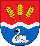
Blazon : “Divided by red and blue by a broad, wavy silver bar, slightly lowered. Above three fan-shaped golden ears of corn, below a red armed, silver swan. "
economy
In addition to agriculture, tourism is an important source of income.
Web links
Individual evidence
- ↑ North Statistics Office - Population of the municipalities in Schleswig-Holstein 4th quarter 2019 (XLSX file) (update based on the 2011 census) ( help on this ).
- ↑ Quoted from the Kaart over den sydlige Del af Slesvig 1864 paa Grundlag af Videnskabernes Selskabs Opmaalinger, København 1864
- ^ M. Mørk Hansen, CL Nielsen: Kirkelig Statistics on Slesvig Stift med historiske og topografiske bemærkninger. Volume 3, Kjøbenhavn 1864, p. 342
- ↑ Allocation of seats after local elections in 2013 ( Memento from March 24, 2016 in the Internet Archive )
- ↑ Schleswig-Holstein's municipal coat of arms


