
Steinburg district
| coat of arms | Germany map |
|---|---|

|

Coordinates: 53 ° 55 ' N , 9 ° 31' E |
| Basic data | |
| State : | Schleswig-Holstein |
| Administrative headquarters : | Itzehoe |
| Area : | 1,056.13 km 2 |
| Residents: | 131,013 (Dec. 31, 2019) |
| Population density : | 124 inhabitants per km 2 |
| License plate : | IZ |
| Circle key : | 01 0 61 |
| NUTS : | DEF0E |
| Circle structure: | 111 parishes |
| Address of the district administration: |
Viktoriastrasse 16-18 25524 Itzehoe |
| Website : | |
| District Administrator : | Torsten Wendt (independent) |
| Location of the Steinburg district in Schleswig-Holstein | |
  |
|
The Steinburg district is a district in the state of Schleswig-Holstein . It belongs to the Hamburg metropolitan region . The most important city and administrative seat is Itzehoe . In 2017, the district was the first in Germany to be awarded the Energy Efficiency Municipality certificate by the German Energy Agency .
geography
The Steinburg district borders in the north on the Rendsburg-Eckernförde district , in the east on the Segeberg district , in the southeast on the Pinneberg district , in the southwest on the Elbe and the state of Lower Saxony (with the Stade district ) and in the west on the North Baltic Sea -Kanal , the border to the Dithmarschen district . The highest point in the district is the Itzespitze with 83.4 m above sea level. NN. Further elevations are the moraine ridge near Itzehoe with a height of 72 m above sea level. NN and the Münsterdorfer Geestinsel with a height of 32 m above sea level. NN.
In the district area, in the Wilstermarsch near Neuendorf-Sachsenbande, there is also the deepest land in Germany (3.54 m below sea level ).
landscape
Determining landscape elements are the march in a 10 to 15 kilometer wide strip in the southwest along the Elbe and the wavy and wooded Geest , here especially the Heide-Itzehoer Geest, characterized by moraines . The Aukrug Nature Park begins in the northeast . The Stör , the third longest river in Schleswig-Holstein, flows through the Steinburg district and flows into the Elbe there.
history
The name "Steinburg" comes from the protective and stronghold castle, the Steinburg , which was first mentioned in a document in 1307 and was built by the Counts of Holstein . It was the seat of the bailiff, who held this office as a hereditary fief, and thus the administrative seat until the 17th century of the office Steinburg was. The Steinburg bailiffs, who continued to expand their position in their own interest, came increasingly into conflict with the counts' sovereigns. After the castle was demolished around 1630, the Steinburg office was administered first from Glückstadt and then from Itzehoe .
During the Thirty Years' War Steinburg was billeted and plundered several times, but mostly there was no major destruction. In 1657 during the Danish-Swedish War (1657–1658), however, there were large pillages by Swedish soldiers.
In the Napoleonic wars , Steinburg was only indirectly affected by transit and billeting as well as financial burdens. From 1807, Itzehoe became the brief residence of Prince Elector Wilhelm I of Hesse-Kassel, who had fled into exile from Napoléon .
Before the Schleswig-Holstein uprising , in which a large part of Steinburg's residents took part in the German-minded Schleswig-Holstein movement, the Holstein Assembly of Estates met in Itzehoe from 1835 to 1848 and again from 1852 to 1863 , thereby establishing the story of parliamentarism in Schleswig-Holstein. After the German-Danish War , the Duchy of Holstein and thus Steinburg initially fell to Austria , whose governor Ludwig Karl Wilhelm von Gablenz finally called the Holstein meeting of the estates together for the last time on June 11, 1866. However, a conference was prevented by the side effects of the German-German war . After the end of the war, the Duchy of Holstein , including Steinburg, finally fell to Prussia.
Through the "Ordinance concerning the organization of the district and district authorities, as well as the district representation in the province of Schleswig-Holstein" of September 22, 1867, the Steinburg office, the cities of Itzehoe, Wilster, Crempe and Glückstadt as well as numerous other localities became the Steinburg district united. The boundary definition of 1867 lasted until the passing of the second law on the reorganization of municipal and district boundaries and judicial districts of December 23, 1969.
The Soviet war cemeteries in the Steinburg district bear witness to the traces of the Second World War .
With effect from April 26, 1970, the communities of Aasbüttel , Agethorst , Besdorf , Bokelrehm , Bokhorst , Gribbohm , Holstenniendorf , Nienbüttel , Nutteln , Oldenborstel , Puls , Schenefeld , Siezbüttel , Vaale , Vaalermoor , Wacken and Warringholz became part of the Rendsburg district Steinburg incorporated and assigned to the office of Schenefeld . As a result, the district grew by approx. 120 km² to today's size.
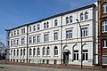
Controversy about the new building of the district administration
The district administration is housed in various buildings in Itzehoe, including three neighboring houses on Viktoriastraße: in the former train station hotel, in the Bollhardt building and in the former district office. The district planned a demolition and a new construction of modern buildings at this point, only the listed district office should remain.
- This was prevented in 2014 in the district's first referendum.
- The facades and roofs of Viktoriastraße were placed under monument protection as a whole by the Schleswig-Holstein State Office for Monument Preservation .
- In June 2017, the Steinburg district filed a lawsuit against the monument protection.
- In April 2018, the district council approved the preservation of the facades.
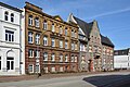
overview
former train station hotel

Bollhardt's building

old district office


Population development

Respective district area
| year | Residents | source |
|---|---|---|
| 1890 | 67,439 | |
| 1900 | 78,836 | |
| 1910 | 83,108 | |
| 1925 | 81,422 | |
| 1939 | 82,999 | |
| 1946 | 161,300 | |
| 1950 | 156.045 | |
| 1960 | 122,300 | |
| 1970 | 131,800 | |
| 1980 | 128,900 | |
| 1990 | 128,600 | |
| 2000 | 136.027 | |
| 2010 | 132,897 |
Current territorial status
The population figures up to 1970 refer to the area on May 27, 1970.
|
|
politics
Pirate Party Germany : 2.7%
Radunski, Helmut: 0.0%
2018:
Blasberg, Gerhard: 0.8%
Dr. Hansen, Siegfried: 0.8%
women for Steinburg: 0.6%

The CDU politician Mark Helfrich is directly elected member of the German Bundestag from the Steinburg district . In the rural communities in the district, the CDU's share of the vote is well above the national average; in the last federal election, the SPD became the third strongest force in one community, behind the CDU and FDP. Overall, the district is rather bourgeois.
District council
The local election on May 6, 2018 led to the following distribution of seats in the district council:
| Political party | Percent 2003 | Percent 2008 | Mandates 2008 | Percent 2013 | Mandates 2013 | Percent 2018 | Mandates 2018 |
|---|---|---|---|---|---|---|---|
| CDU | 54.5% | 43.9% | 24 | 40.1% | 18th | 39.3% | 22nd |
| SPD | 27.7% | 25.0% | 13 | 27.7% | 13 | 21.2% | 12 |
| GREEN | 8.2% | 9.4% | 5 | 11.4% | 5 | 14.3% | 8th |
| FDP | 5.5% | 9.3% | 5 | 5.6% | 3 | 7.4% | 4th |
| AfD | - | - | - | - | - | 6.1% | 3 |
| THE LEFT. | - | 6.1% | 3 | 2.0% | 1 | 3.9% | 2 |
| Citizens' List Steinburg (BLS) | - | - | - | 5.5% | 2 | 2.0% | 1 |
| FREE VOTERS | - | - | - | 2.6% | 1 | 2.0% | 1 |
| Voting Initiative Steinburg (WISt) | 4.1% | 5.4% | 2 | 2.4% | 1 | 1.7% | 1 |
| Blasberg, Gerhard | - | - | - | - | - | 0.8% | - |
| Dr. Hansen, Siegfried | - | - | - | - | - | 0.8% | - |
| Women for Steinburg | - | - | - | - | - | 0.6% | - |
| PIRATES | - | - | - | 2.7% | 1 | - | - |
| Radunski, Helmut | - | - | - | 0.0% | - | - | - |
| Democrats | - | 0.8 | - | - | - | - | - |
| total | 100 | 100 | 52 | 100 | 45 | 100 | 54 |
| Turnout in percent | k. A. | 49.8 | 49.6 | 49.3 | |||
After the local elections in 2018, the district council members of FREIE WÄHLER and BLS form a joint parliamentary group. The WISt district council member is the only one to remain non-attached.
District administrators
- 1868–1889: Ernst Christian von Harbou
- 1889–1891: Ferdinand Berg
- 1891–1903: Franz Karl Konstantin Hermann Jungé
- 1903–1904: Konrad von Rittberg
- 1904–1923: Reinhard Pahlke
- 1923–1932: Konrad Göppert
- 1932–1936: Wilhelm Ide
- 1936–1945: Friedrich Karl von Lamprecht
- 1945–1946: Adolf Rohde
- 1946–1946: Carl Stein
- 1946–1947: Wilhelm Käber , ( SPD )
- 1947–1948: Willi Steinhörster , ( SPD )
- 1948–1950: Adolf Rohde
- 1950–1954: Georg Pahlke
- 1955–1972: Peter Matthiessen
- 1972–1982: Helmut Brümmer
- 1982–2009: Burghard Rocke, ( CDU )
- 2009–2010: Heinz Seppmann, (CDU)
- 2010–2012: Jens Kullik, ( non-party ) (voted out on May 14, 2012)
- 2012-2013: Heinz Seppmann (CDU) (as honorary deputy of the elected district administrator Kullik)
- since 2013: Torsten Wendt (independent)
District Presidents
- 1950–1950: Hans Frese
- 1950–1951: Emil Staben, SPD
- 1951–1962: Peter Dohrn, CDU
- 1962–1966: Emil Staben, SPD
- 1966–1970: Peter Dohrn, CDU
- 1970–1974: Alfred von Rosenberg
- 1974–1982: Annemarie Degkwitz, CDU
- 1982–1990: Georg Rösler, CDU
- 1990–1994: Doris Reich, CDU
- 1994–2003: Klaus-Peter Wenzlaff, SPD
- 2003–2013: Hans-Friedrich Tiemann († 2020), CDU
- Since 2013: Peter Labendowicz, CDU
coat of arms
Blazon : “In red over blue waves a silver castle with three blue-roofed tin towers; three shields placed under the crenellated crown: 1. Christ clad in silver and gold with his right hand raised as a blessing, holding the red globe in his left hand; 2. a silver nettle leaf in red; 3. In red, a silver swan ready to fly with a gold crown around its neck. "
flag
Blazon : “The flag of the Steinburg district bears the coat of arms in the first third of the white flag. The flag is bordered above and below by a blue border, which symbolically represents the rivers Stör and Elbe. "
Economy and Transport
In the Future Atlas 2016 , the Steinburg district was ranked 277 out of 402 districts, municipal associations and urban districts in Germany, making it one of the regions with a “balanced risk-opportunity mix” for the future.
Important road connections
- Itzehoe – Hamburg ( A 23 )
- Itzehoe – Kiel
- Itzehoe-Lübeck ( B 206 )
- Itzehoe – Heide (A 23)
- Itzehoe – Brunsbüttel
- Itzehoe – Glückstadt
Major ferries
- Elbe ferry Glückstadt – Wischhafen
- Sturgeon ferry Else in Beidenfleth
- Ferries across the Kiel Canal: Brunsbüttel, Ostermoor, Kudensee, Burg, Hochdonn, Hohenhörn
Rail transport
- Hamburg – Itzehoe – Westerland (Sylt)
- Hamburg - Elmshorn - Horst - Wrist - Kiel
- Wrist – Itzehoe railway line , discontinued passenger services in 1975 and completely dismantled today (2016).
Ports
- Glückstadt (outer harbor), water depth 6.00 m at MHw (medium flood)
- Glückstadt (inland port), water depth 4.50 m at Nw (low water)
- Itzehoe (Suder Hafen), water depth 3.80 m at MThw (mean tidal high water)
Communities
(Residents on December 31, 2019)
| Municipalities not in office | |
|---|---|
|
|
Offices with official municipalities (* = seat of the official administration)
Municipality and office map

Former parishes
The following list contains all former municipalities in the Steinburg district:
| local community | incorporated after |
Date of incorporation |
|---|---|---|
| Bekhof | Oldendorf | January 1, 1976 |
| Edendorf | Itzehoe | June 1, 1963 |
| Eversdorf | Kaaks | April 1, 1939 |
| Grönhude | Kellinghusen | March 19, 1900 |
| Great Kollmar | Kollmar | September 1, 1974 |
| Itzehoer Klosterhof | Itzehoe | April 1, 1936 |
| Klein Kollmar | Kollmar | September 1, 1974 |
| Moordorf | Westermoor | March 1, 2008 |
| Mühlenbek | Kellinghusen | March 19, 1900 |
| Neuendorf near Wilster | Neuendorf-Sachsenbande | January 1, 2003 |
| Overndorf | Kellinghusen | March 19, 1900 |
| Rahde | Kleve | January 1, 1978 |
| Rensing | Kellinghusen | April 1, 1960 |
| Sachsenbande | Neuendorf-Sachsenbande | January 1, 2003 |
| Siebenecksknöll | Wulfsmoor | April 1, 1970 |
| Siezbüttel | Schenefeld | January 1, 2013 |
| Stellau | Wrist | April 1, 1938 |
| Brew | Itzehoe | November 1, 1911 |
| Vorbruges | Kellinghusen | March 19, 1900 |
The municipality of Lockstedter Lager was renamed Hohenlockstedt in 1956 .
Protected areas
There are eight designated nature reserves in the circle (as of February 2017).
License Plate
On July 1, 1956, the district was assigned the distinctive sign IZ (Itzehoe) when the license plates that are still valid today were introduced . It is still issued today. The combination IZ-AN xx is not output (NAZI read backwards).
literature
- Paul Holtorf: Chronicle of the Steinburg district 1307 to 1967. Itzehoe 1967.
Web links
Individual evidence
- ↑ North Statistics Office - Population of the municipalities in Schleswig-Holstein 4th quarter 2019 (XLSX file) (update based on the 2011 census) ( help on this ).
- ↑ Number one in climate protection
- ↑ Steinburg district receives award for commitment to climate protection ( Memento from February 2, 2017 in the Internet Archive )
- ↑ PrGS 1867, 1587
- ↑ District House facade: referendum successfully , shz.de, North German Rundschau , July 6, 2014
- ↑ Monument protection in Viktoriastraße , steinburg.de, accessed on August 21, 2018
- ↑ a b Kreishaus-Neubau: Lawsuit against monument protection , shz.de, Norddeutsche Rundschau , June 9, 2017
- ↑ Kreishaus facades remain , shz.de, Norddeutsche Rundschau , April 6, 2018
- ↑ a b c d e f g h i Michael Rademacher: German administrative history from the unification of the empire in 1871 to the reunification in 1990. steinburg.html. (Online material for the dissertation, Osnabrück 2006).
- ↑ 1946 census
- ↑ Statistical Yearbook for the Federal Republic of Germany 1972
- ↑ Statistical Yearbook for the Federal Republic of Germany 1981
- ↑ a b North Statistics Office
- ↑ State Statistical Office Schleswig-Holstein (Ed.): The population of the communities in Schleswig-Holstein 1867-1970 . State Statistical Office Schleswig-Holstein, Kiel 1972, p. 21 .
- ↑ http://www.steinburg.de/politik/wahlen.html
- ↑ [1]
- ↑ [2]
- ↑ [3]
- ↑ [4]
- ↑ [5]
- ↑ Steinburg's district administrator voted out of office
- ↑ Torsten Wendt elected district administrator ( memento of the original from December 26, 2015 in the Internet Archive ) Info: The archive link was inserted automatically and has not yet been checked. Please check the original and archive link according to the instructions and then remove this notice.
- ↑ Steinburg district mourns the loss of its former president Fiete Tiemann
- ↑ Peter Labendowicz is the new district president
- ↑ a b Schleswig-Holstein's municipal coat of arms
- ↑ Zukunftsatlas 2016. Archived from the original ; accessed on March 23, 2018 .
- ↑ North Statistics Office - Population of the municipalities in Schleswig-Holstein 4th quarter 2019 (XLSX file) (update based on the 2011 census) ( help on this ).
- ^ Community directory Steinburg district
- ^ Territorial.de: Steinburg district
- ↑ Community encyclopedia for the Free State of Prussia: Province of Schleswig-Holstein Verlag des Prussian State Statistical Office, 1930
- ↑ Desired license plate
Independent cities: Flensburg | Kiel | Lübeck | Neumunster
Districts: Dithmarschen | Duchy of Lauenburg | North Friesland | Ostholstein | Pinneberg | Plön | Rendsburg-Eckernförde | Schleswig-Flensburg | Segeberg | Stone castle | Stormarn