
Frahier-et-Chatebier
| Frahier-et-Chatebier | ||
|---|---|---|

|
|
|
| region | Bourgogne-Franche-Comté | |
| Department | Haute-Saône | |
| Arrondissement | Lure | |
| Canton | Héricourt-1 | |
| Community association | Rahin et Cherimont | |
| Coordinates | 47 ° 40 ′ N , 6 ° 45 ′ E | |
| height | 352-493 m | |
| surface | 17.39 km 2 | |
| Residents | 1,378 (January 1, 2017) | |
| Population density | 79 inhabitants / km 2 | |
| Post Code | 70400 | |
| INSEE code | 70248 | |
 Mairie Frahier-et-Chatebier |
||

Frahier-et-Chatebier is a French commune with 1,378 inhabitants (January 1, 2017) in the Haute-Saône department in the Bourgogne-Franche-Comté region . It belongs to the arrondissement of Lure , the canton of Héricourt-1 and the Rahin et Chérimont municipal association, which was founded in 2002 .
geography
The community is located on the Lizaine , about ten kilometers west-northwest of Belfort .
The Canal de la Haute-Saône (German: Haute-Saône Canal ) crosses the municipality. Construction of the canal began in 1882, was interrupted during the First World War and was not continued afterwards. Only the part between Botans and the confluence with the Canal du Rhône au Rhin was completed and put into operation in 1926. The section between Botans and Ronchamp is a monument that has never been functional and is now often used for leisure activities.
Neighboring communities of Frahier-et-Chatebier are Plancher-Bas and Errevet in the north, Évette-Salbert in the east, Châlonvillars in the south-east, Chagey in the south, Chenebier in the south-west, Échavanne in the west and Champagney in the north-west.
history
In the Franco-Prussian War of 1870–1871 , the battle of the Lisaine took place on the territory of the municipality .
Population development
| year | 1962 | 1968 | 1975 | 1982 | 1990 | 1999 | 2008 |
| Residents | 572 | 575 | 616 | 907 | 1.005 | 1,038 | 1,158 |
Attractions
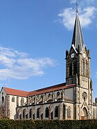
- Saint-Valbert church in Frahier-et-Chatebier


Web links
- Community presentation (French)