
Flintbek
| coat of arms | Germany map | |
|---|---|---|

|
Coordinates: 54 ° 15 ' N , 10 ° 4' E |
|
| Basic data | ||
| State : | Schleswig-Holstein | |
| Circle : | Rendsburg-Eckernförde | |
| Office : | Flintbek | |
| Height : | 50 m above sea level NHN | |
| Area : | 17.57 km 2 | |
| Residents: | 7265 (Dec. 31, 2019) | |
| Population density : | 413 inhabitants per km 2 | |
| Postal code : | 24220 | |
| Area code : | 04347 | |
| License plate : | RD, ECK | |
| Community key : | 01 0 58 053 | |
| LOCODE : | DE FLK | |
| Address of the municipal administration: |
Heitmannskamp 2 24220 Flintbek |
|
| Website : | ||
| Mayor : | Olaf Plambeck | |
| Location of the municipality of Flintbek in the Rendsburg-Eckernförde district | ||
 |
||

Flintbek is a municipality in the Rendsburg-Eckernförde district in Schleswig-Holstein . It is located about 13 km southwest of Kiel and is divided into the districts of Kleinflintbek, Großflintbek and Voorde.
history
In today's Flintbek there are traces of settlement from the Stone Age . The first documentary mention comes from the year 1220. The building of the Flintbeker church was allowed in 1223 according to the document. When the church was actually built is unclear.
At first there was only one place Flintbek. When in 1327 a settlement outside the town belonging to Flintbek received the addition "Klein", the main town was renamed "Großflintbek". Kleinflintbek has around 500 inhabitants today and the Kleinflintbek volunteer fire brigade, founded in 1884, is the oldest of the three former fire brigades in the community. The Großflintbek volunteer fire brigade was founded in 1886, and the Voorde volunteer fire brigade in 1889. In 2019, the local guardians Voorde and Großflintbek merged to form the local guardianship Flintbek.
In 1845 the municipality of Voorde became a railway station after the Altona - Kiel railway line was built. The station is in the Voorde district, right on the border with Großflintbek and was named Voorde (although Großflintbek was larger). The post office established later was also given the name Voorde. The station made it possible for people to move in who found work in Kiel , which is now easily accessible , and also opened a number of shops and craft businesses. Above all, it was a class of wealthy elderly people (pensioners, former tenants, business people) who wanted to spend their evening in Flintbek. The former sand pit became a particularly beautiful facility due to the construction project carried out by the factory owner Lassen in 1907 and contributed significantly to the structural change in the village of Voorde. This is how a well-kept villa complex was created, separated from the old farming village. The rural element was strongly pushed back by this development. The financially strong, agile, and influential business people and retirees gained greater influence. They looked after the place and were open to many innovations. For example, the village of Voorde received an electricity station before the turn of the century, and the Lassenhäuser a central water supply, which was still in operation in 1951.
Today's municipal area originally consisted of the three municipalities Großflintbek, Kleinflintbek and Voorde, which together with Böhnhusen belonged to the Flintbek district and thus to the Kiel and Bordesholm districts . After the Bordesholm district was dissolved in 1932, the municipalities became part of the Plön district .
In 1937 Voorde was incorporated into Großflintbek. In 1938 Kleinflintbek was incorporated and renamed Flintbek. In 1948 Flintbek became an unofficial municipality.
On March 29, 1944, the Gestapo murdered four prisoners of war who had previously broken out of Stalag Luft III . Since March 29, 2018, a memorial plaque in the Rotenhahn district on Landesstrasse 318 has been commemorating the event.
In 1970 it was incorporated into the Rendsburg-Eckernförde district. Since then Flintbek forms with the communities Böhnhusen , Schönhorst and Techelsdorf the Office Flintbek and performs management operations for this office.
Place name
In 1223 the place name is written as "uilla Vlintbeke". In 1338 Kleinflintbek was called "Lutteken Vlyntbeke". As a compound from Old Saxon vlint- and -bek , the name means Bach with the flint stones . The brook name passed on to the settlement.
politics
Community representation
After the municipal elections on May 6, 2018, the 19 seats of the municipal council are distributed among the parties and lists as follows:
| Party / list | CDU | SPD | Green | FDP | UWF * |
|---|---|---|---|---|---|
| Seats | 6th | 5 | 3 | 2 | 3 |
| Share of votes | 28.9% | 25.8% | 16.5% | 12.2% | 16.6% |
* Flintbek independent voter community
coat of arms
Blazon : “Divided by a 3: 1 split, blue above, silver below, wavy bar of silver and green. Top three upright stalked green oak leaves side by side, below the cutting edge of pioneering below geschäftetes silver Flintbeil. "
The three oak leaves symbolically represent the three districts of Voorde, Großflintbek and Kleinflintbek with their village oaks that are still preserved today. The two wavy bands stand for the rivers Eider and Flintbek flowing through the town, and the flint ax symbolizes the archaeological importance of the Flintbek area.
Community partnerships
Flintbek has had a community partnership with the Italian city of Romano d'Ezzelino since 1985 .
Attractions
The list of cultural monuments in Flintbek includes the cultural monuments entered in the list of monuments of Schleswig-Holstein.
The Eidertal hiking trail runs partly through the municipality of Flintbek and invites nature lovers to take long walks.
Particularly worth seeing are the Flintbeker Church , built from 1223, and the around 1000-year-old Flintbeker yew tree .
The unheated outdoor pool on the outskirts is a focal point for locals in summer.
Opposite the open-air swimming pool is a canoe landing stage, from which you can navigate the Eider through the Eider Valley in both directions and pass places that cannot be reached on land.
Flintbeker sickle
In the years from 1977 to 1996 in the Feldmark of the municipality of Flintbek with the so-called "Flintbeker Sichel" a Bronze Age and Iron Age cemetery with over 70 sites was archaeologically opened up over 4 km. In the process, one from the 4th millennium BC and thus the "world's oldest track of a wheeled vehicle" was discovered. In addition, from the time of 1700 BC. Until 1000 BC Traces of hook plowing originating in BC. The grave finds of the so-called "Ilmenau woman" from the 15th century BC indicate that a woman was buried there who had immigrated from northern Lower Saxony.
Personalities
- Martin Coronaeus (1588-1665), pastor
- Wilhelm Biernatzki (1855–1940), farmer, journalist and association official
- Hans Heitmann (1904–1970), teacher and writer, wrote mainly in the Low German language
- Werner Loch (1928–2010), Professor of General Education (Kiel University)
- Martin Metzger (1928–2018), professor emeritus for Old Testament and Biblical Archeology (University of Kiel)
- Jürgen Newig (1941–2015), Professor of Geography and Geography Didactics (University of Kiel)
- Andrea Schacht (1956–2017), writer
- Axel Möller (* 1957), soccer player
photos

Replica of a death hut from Flintbek in the Archaeological-Ecological Center Albersdorf

Voorde station around 1930 with first and second class waiting rooms
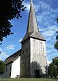
Flintbeker Church

Pottery kate in the village street


Web links
- Flintbek municipality
- The Flintbek barrow field after twenty years of excavation , Bernd Zich (PDF file; 2.03 MB)
Individual evidence
- ↑ North Statistics Office - Population of the municipalities in Schleswig-Holstein 4th quarter 2019 (XLSX file) (update based on the 2011 census) ( help on this ).
- ↑ Schleswig-Holstein topography. Vol. 3: Ellerbek - Groß Rönnau . 1st edition Flying-Kiwi-Verl. Junge, Flensburg 2003, ISBN 978-3-926055-73-6 , p. 125 ( dnb.de [accessed on April 21, 2020]).
- ↑ Translation of the certificate in: Festschrift - 777 Years Church Flintbek, Ed. Manfred Schade, Flintbek 2000, p. 7.
- ↑ Murder of 1944: memorial plaque commemorates the Gestapo's bloody act
- ^ Manfred Niemeyer (ed.): German book of place names . De Gruyter, Berlin 2012, ISBN 978-3-11-018908-7 , pp. 177 .
- ↑ 2018 Flintbek municipal elections , accessed on January 21, 2020
- ↑ Schleswig-Holstein's municipal coat of arms
- ↑ Bernd Zich, The Flintbek barrow field after twenty years of excavation, in: Yearbook of the Bordesholm History Association 1st year 1999, p. 8.
Backguard | Ahlefeld-Bistensee | Alt Duvenstedt | Altenhof | Altenholz | Arpsdorf | Cinderella | Aukrug | Bargstall | Bargstedt | Barkelsby | Beldorf | Bendorf | Beringstedt | Bite | Blumenthal | Böhnhusen | Bokel | Bordesholm | Borgdorf-Seedorf | Borgstedt | Bornholt | Bovenau | Brammer | Bredenbek | Pulpwood | Brekendorf | Brinjahe | Brodersby | Bruges | Büdelsdorf | Bünsdorf | Christiansholm | Damendorf | Damp | Dänischenhagen | Dätgen | Dörphof | Eckernförde | Ehndorf | Eisendorf | Ellerdorf | Elsdorf-Westermühlen | Embühren | Emkendorf | Field | Felm | Fleckeby | Flintbek | Fockbek | Friedrichsgraben | Friedrichsholm | Gammelby | Gettorf | Gnutz | Gokels | Goosefeld | Grauel | Grevenkrug | Groß Buchwald | Groß Vollstedt | Groß Wittensee | Güby | Haale | Haby | Hamdorf | Hamweddel | Hanerau-Hademarschen | Hassmoor | Heinkenborstel | Hofeld | Hohenwestedt | Scorn | Holtsee | Holzbunge | Holzdorf | Hearst | Hummelfeld | Huts | Year village | Jevenstedt | Karby | Klein Wittensee | King's Hill | Kosel | Crogaspe | Kronshagen | Curvilinear | Long tail | Lindau | Lohe-Föhrden | Loop | Loose | Luhnstedt | Lütjenwestedt | Meezen | Melsdorf | Mielkendorf | Molfsee | Mörel | Mühbrook | Negenharry | Neudorf-Bornstein | New Duvenstedt | Neuwittenbek | Nienborstel | Nindorf | Noer | Nortorf | Nübbel | Oldenbüttel | Oldenhütten | Osdorf | Ostenfeld (Rendsburg) | Osterby | Osterrönfeld | Osterstedt | Ottendorf | Owschlag | Padenstedt | Prince's Moor | Quarnbek | Rade b. Hohenwestedt | Rade b. Rendsburg | Reesdorf | Remmels | Rendsburg | Rickert | Rieseby | Rodenbek | Rumohr | Schacht-Audorf | Schierensee | Schinkel | Schmalstede | Schönbek | Schönhorst | Schülldorf | Schülp b. Nortorf | Schülp b. Rendsburg | Schwedeneck | Seefeld | Sehestedt | Sophienhamm | Sören | Stafstedt | Steenfeld | Beaches | Tackesdorf | Tappendorf | Techelsdorf | Thaden | Thumby | Timmaspe | Todenbüttel | Tüttendorf | Waabs | Wapelfeld | Warder | Wasbek | Wattenbek | Westensee | Westerrönfeld | Windeby | Winnemark