Rochefort (Savoie)
| Rochefort | ||
|---|---|---|
|
|
||
| region | Auvergne-Rhône-Alpes | |
| Department | Savoie | |
| Arrondissement | Chambery | |
| Canton | Bugey savoyard | |
| Community association | Val Guiers | |
| Coordinates | 45 ° 35 ' N , 5 ° 43' E | |
| height | 298-700 m | |
| surface | 5.60 km 2 | |
| Residents | 232 (January 1, 2017) | |
| Population density | 41 inhabitants / km 2 | |
| Post Code | 73240 | |
| INSEE code | 73214 | |
| Website | www.commune-rochefort-savoie.org | |
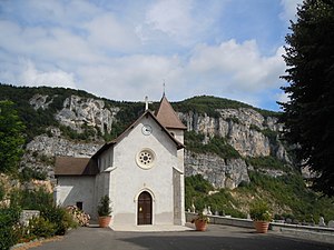
 The Saint-Blaise village church of Rochefort |
||
Rochefort is a French municipality with 232 inhabitants (at January 1, 2017) in the department of Savoie in the region of Auvergne Rhône-Alpes . It belongs to the canton of Bugey Savoyard in the Arrondissement of Chambéry and is a member of the Val Guiers municipal association .
geography
location
Rochefort is located on the western edge of the department at 422 m , about 16 kilometers west of the prefecture of Chambéry , 71 kilometers east-southeast of Lyon and 44 kilometers north of the city of Grenoble (as the crow flies). Neighboring municipalities of Rochefort are
- Sainte-Marie-d'Alvey in the north,
- Novalaise and Ayn in the east,
- Verel-de-Montbel in the south,
- Avressieux and
- Saint-Genix-les-Villages with Saint-Genix-sur-Guiers in the west and Gresin in the northwest.
topography
The area of the municipal area of 5.60 km 2 covers a section of the Avant-Pays Savoyard , the Savoyard foreland characterized by gentle elevations between the border river Guiers and the southern end of the main anticlines of the Jura . The eastern edge of the commune is formed by a step in the north-south direction, here about 400 m high, which separates the valley floors of the Rhone and Guiers from the plateau occupied by Lac d'Aiguebelette east of the commune. The terrain is almost entirely characterized by vertically rising rock walls. The Truison brook marks the northern border of the municipality and drains parts of the municipality towards the Rhone. The gently hilly municipality to the west of the terrain is largely used for agriculture. Forests make up about 26% of the area.
Community structure
In addition to the actual, very small town center, Rochefort also includes several hamlet settlements and farms, including:
- Urice ( 472 m ) in the northwestern tip of the municipality as well
- Le Suard and Le Vivier (both 375 m ) at the foot of the step.
history
An independent parish was mentioned at Rochefort in the 14th century ( Parrocchia de Rupeforti aliàs Rochefort ). For several centuries, both name variants existed in parallel.
Attractions
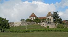
The Château de Rochefort or Château de Mandrin on a hill above the village dates from the 15th century and is regionally known as the refuge of the robber captain and smuggler Louis Mandrin from the 18th century. The village church of Saint-Blaise was built in the 19th century. Natural attractions include the rock formations in the terrain between the Col de la Crusille and the Col du Blanchet , a nature reserve under the Natura 2000 network .
Population development
| year | Residents |
|---|---|
| 1962 | 152 |
| 1968 | 143 |
| 1975 | 148 |
| 1982 | 120 |
| 1990 | 152 |
| 1999 | 175 |
| 2006 | 199 |
| 2011 | 199 |
With 232 inhabitants (as of January 1, 2017) Rochefort is one of the small communities in the Savoie department. After the population declined during the late 19th and 20th centuries (442 inhabitants were counted in 1861), this development stopped in 1990. The local residents of Rochefort are called Rochefoliars in French .
Economy and Infrastructure
Rochefort is still a predominantly agricultural village. Around a dozen larger farms are primarily geared towards milk production . There are also a few small local businesses. In the meantime the village has also developed into a residential community. Many employed people are commuters who work in the larger towns in the area and in the neighboring departments.
The village is located away from the larger thoroughfares at the intersection of several departmental roads that connect the village center with the neighboring towns of Sainte-Marie-d'Alvey, Saint-Genix and Avressieux. The next motorway connection to the A43 (Lyon – Chambéry) is nine kilometers away at Belmont-Tramonet. The airports in the region are Lyon-St-Exupéry (distance 67 km) and Chambéry-Savoie (28 km).
Web links
Individual evidence
- ↑ 2006 data from CORINE Land Cover , available e.g. B. at www.statistiques.developpement-durable.gouv.fr ( Memento of the original from March 24, 2016 in the Internet Archive ) Info: The archive link has been inserted automatically and has not yet been checked. Please check the original and archive link according to the instructions and then remove this notice. .
- ^ JJ Vernier: Dictionnaire topographique du département de la Savoie . Imprimerie Savoisienne, 1896, p. 621 (French, online on BNF [accessed January 19, 2014]).
- ↑ French Statistics Institute ( www.insee.fr )
- ^ Rochefort - notice communale. In: cassini.ehess.fr. Retrieved on April 26, 2015 (French, INSEE population from 1968 ).
- ^ Complete dossier on Rochefort. In: INSEE . Retrieved April 26, 2015 (French).


