Alaincourt (Haute-Saône)
| Alaincourt | ||
|---|---|---|

|
|
|
| region | Bourgogne-Franche-Comté | |
| Department | Haute-Saône | |
| Arrondissement | Lure | |
| Canton | Jussey | |
| Community association | Haute Comté | |
| Coordinates | 47 ° 57 ' N , 6 ° 6' E | |
| height | 235-285 m | |
| surface | 5.83 km 2 | |
| Residents | 112 (January 1, 2017) | |
| Population density | 19 inhabitants / km 2 | |
| Post Code | 70210 | |
| INSEE code | 70010 | |
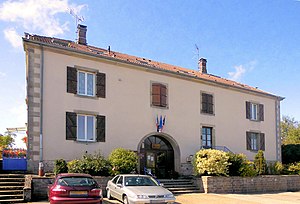
 Mairie Alaincourt |
||
Alaincourt is a municipality in the French department of Haute-Saône in the region Bourgogne Franche-Comté .
geography
Alaincourt is located at an altitude of 248 m above sea level, two and a half kilometers north of Vauvillers and about 36 kilometers north of the city of Vesoul (as the crow flies). The village extends in the northern part of the department, in the basin of the Ruisseau de la Prairie south of the Côney , at the northern foot of the heights of Vauvillers.
The area of the 5.83 km² municipal area covers a section in the gently undulating landscape east of the upper Saône valley . The northern part of the municipality is occupied by the alluvial plain of the Côney, which marks the northern border in sections. The waterway of the Canal de l'Est runs parallel to the north of the river . The flood plain averages 235 m and is approximately one kilometer wide.
From the course of the river, the municipal area extends southward into the basin of its side stream Ruisseau de la Prairie . Agricultural use prevails here. The hollow is flanked by a plateau with extensive forests: Bois de Foignouse in the west and Bois de la Craie in the east. Towards the south the plateau rises slightly, so that at the foot of the heights of Vauvillers the highest point of Alaincourt is reached at 285 m. In geological and tectonic terms, the area consists of red sandstone from the Lower Triassic and shell limestone from the Central Triassic.
Neighboring municipalities of Alaincourt are Selles and Pont-du-Bois in the north, Vauvillers in the east and Montdoré in the south and west.
history
In the Middle Ages, Alaincourt belonged to the Free County of Burgundy and in it to the area of the Bailliage d'Amont . The lords of Vauvillers held local rule. Later, the place was divided between the Free County and the Duchy of Bar. With the invasion of the French king in Franche-Comté , Alaincourt came to France in 1674.
Attractions
The Saint-Nicolas church was built in the 15th and 16th centuries in the Gothic style. The facade and part of the nave were rebuilt in 1840. The church has a flamboyant portal and statues from the 15th century. Three lavoirs along Rue des Fontaines-Fleuries date from the 19th century and were once used as a wash house and cattle trough. To the north of the village is a 17th century Calvaire .
population
| Population development | |
|---|---|
| year | Residents |
| 1962 | 108 |
| 1968 | 92 |
| 1975 | 82 |
| 1982 | 72 |
| 1990 | 85 |
| 1999 | 89 |
| 2006 | 96 |
With 112 inhabitants (January 1, 2017) Alaincourt is one of the smallest communes in the Haute-Saône department. After the population had decreased significantly in the first half of the 20th century (186 people were still counted in 1881), slight population growth has been recorded since the beginning of the 1980s.
Economy and Infrastructure
Until well into the 20th century, Alaincourt was primarily a village characterized by agriculture (arable farming, fruit growing and cattle breeding) and forestry. Today there are some local small businesses, especially in wood processing. In the last few decades the village has transformed into a residential community. Many workers are therefore commuters who work in the larger towns in the area.
The village is located off the major thoroughfares on a departmental road that leads from Vauvillers to Passavant-la-Rochère . There are other road connections with Pont-du-Bois and Montdoré.


