Moffans-et-Vacheresse
| Moffans-et-Vacheresse | ||
|---|---|---|
|
|
||
| region | Bourgogne-Franche-Comté | |
| Department | Haute-Saône | |
| Arrondissement | Lure | |
| Canton | Lure-2 | |
| Community association | Pays de Lure | |
| Coordinates | 47 ° 38 ' N , 6 ° 33' E | |
| height | 280-369 m | |
| surface | 14.09 km 2 | |
| Residents | 625 (January 1, 2017) | |
| Population density | 44 inhabitants / km 2 | |
| Post Code | 70200 | |
| INSEE code | 70348 | |
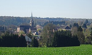
 View of Moffans-et-Vacheresse |
||
Moffans-et-Vacheresse is a commune in the French department of Haute-Saône in the region Bourgogne Franche-Comté .
geography
Moffans-et-Vacheresse is located at an altitude of 296 m above sea level, seven kilometers southeast of Lure and about 30 kilometers east of the city of Vesoul (as the crow flies). The village extends in the eastern part of the department, slightly elevated west of the Rognon lowland , on the northwestern edge of the heights of Granges.
The area of the community area of 14.09 km² covers a section in the undulating landscape southeast of the Lure plain. From northeast to southwest, the area is crossed by the Rognon valley, which provides drainage over the Scey to the Ognon . The alluvial low lies on average 290 m and has a width of around 500 meters. On the parish soil, the Rognon receives a tributary from several side streams, including the Ruisseau de Courmont . The watercourses are dammed into ponds (fish farming) in various places. The largest is the Étang Neuf on the edge of the Grand Bois.
To the west of the Rognon Valley, the area extends to a plateau made of shell limestone from the Middle Triassic . It consists partly of arable and meadow land, in the western part mainly of forest ( Grand Bois ) and reaches a height of 324 m. East of the Rognon, the terrain rises rapidly to the forest-covered heights of Granges. Here are the heights of Derrière le Moulin (up to 362 m) and Bois de Saint-Georges , where the highest point of Moffans-et-Vacheresse is reached at 369 m. Together with the series of hills of Mont Rebrassier (343 m), Les Fouillies (331 m) and Rougemont (352 m) west of the Rognon, they are mainly made of red sandstone from the Lower Triassic.
The double community consists of the village of Moffans (296 m) and the hamlet of Vacheresse (293 m) in the valley of the Ruisseau de Courmont just before its confluence with the Rognon. Neighboring municipalities of Moffans-et-Vacheresse are Frotey-lès-Lure and Lyoffans in the north, Lomont in the east, Granges-la-Ville and Athesans-Étroitefontaine in the south and La Vergenne , Vouhenans and Lure in the west.
history
Remains of the Roman traffic route from Luxeuil to Mandeure indicate an early inspection of the area. Moffans is first mentioned in 1175 under the name Mofens . The spelling Mofans is from 1344 and the current name from 1377. In the Middle Ages Moffans belonged to the Free County of Burgundy and in it to the area of the Bailliage d'Amont . The area reclaimed in the 12th century belonged to the Granges rule, whose vassals resided here. Together with Franche-Comté , the place finally came to France with the Peace of Nijmegen in 1678.
Vacheresse formed an independent municipality since the French Revolution before it was incorporated into Faymont in 1808 , with which it however had no common border. The Vacheresse exclave was separated from Faymont in 1923 and merged with Moffans to form a double community. Today Moffans-et-Vacheresse is a member of the community association Communauté de communes du Pays de Lure, which comprises 22 villages .
Attractions
The Saint-Christophe church was rebuilt in 1839 with red sandstone as the building structure, and the bell tower with a pyramid roof was added in 1862. The remarkable furnishings include the furniture (18th century) from the earlier church, a bas-relief with St. Christopher , paneling from the 19th century and several grave slabs.
Several houses in the village date from the 18th and 19th centuries, including the Mairie (parish hall) and the rectory. Other sights include a fountain with a pavilion at the entrance to the village and the covered lavoir from the 19th century, which once served as a wash house and cattle trough.
population
| Population development | |
|---|---|
| year | Residents |
| 1962 | 481 |
| 1968 | 454 |
| 1975 | 554 |
| 1982 | 555 |
| 1990 | 549 |
| 1999 | 531 |
| 2006 | 570 |
With 625 inhabitants (January 1, 2017), Moffans-et-Vacheresse is one of the medium-sized municipalities in the Haute-Saône department. After the population had decreased significantly in the first half of the 20th century (819 people were still counted in 1886), population growth was recorded again at the beginning of the 1970s. Since then, the population has remained at a constant level.
Economy and Infrastructure
Until well into the 20th century, Moffans-et-Vacheresse was primarily a village characterized by agriculture (arable farming, fruit growing and cattle breeding) and forestry. The hydropower of the Rognon was formerly used to operate mills. Today there are various local small businesses. In the last few decades the village has transformed into a residential community. Many workers are therefore commuters who work in the larger towns in the area.
The village is located off the major thoroughfares on a department road that leads from Villersexel to Ronchamp . Other road connections exist with Frotey-lès-Lure, Vouhenans and Lomont.
