Route national 118
| Route Nationale 118 in France | ||||||||||||||||||||||||||||||||||||||||||||||||||||||||||||||||||||||||||||||||||||||||||||||||||||||||||||||||
| N 118 | ||||||||||||||||||||||||||||||||||||||||||||||||||||||||||||||||||||||||||||||||||||||||||||||||||||||||||||||||
| Basic data | ||||||||||||||||||||||||||||||||||||||||||||||||||||||||||||||||||||||||||||||||||||||||||||||||||||||||||||||||
| Operator: | ||||||||||||||||||||||||||||||||||||||||||||||||||||||||||||||||||||||||||||||||||||||||||||||||||||||||||||||||
| Overall length: | 43 + 99 + 57 km | |||||||||||||||||||||||||||||||||||||||||||||||||||||||||||||||||||||||||||||||||||||||||||||||||||||||||||||||
|
Regions : |
||||||||||||||||||||||||||||||||||||||||||||||||||||||||||||||||||||||||||||||||||||||||||||||||||||||||||||||||
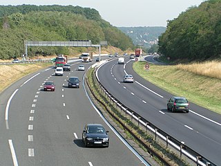
| N 118 at Chevreuse 2006, looking north | ||||||||||||||||||||||||||||||||||||||||||||||||||||||||||||||||||||||||||||||||||||||||||||||||||||||||||||||||
|
Course of the road
|
||||||||||||||||||||||||||||||||||||||||||||||||||||||||||||||||||||||||||||||||||||||||||||||||||||||||||||||||
The N118 is a French national road that was established in 1824 between Albi and Mont-Louis . It goes back to the route impériale 138. Their length was 199 kilometers. In 1973 the N112 took over the section between Albi and Castres and the N118 was stepped between Mazamet and Mont-Louis. In 1978 a new N118 was formed between Sèvres and exit 14 of the A10 in the greater Paris area :
Most of the section taken over from the N187 is the N287 side branch built as an expressway. This was also numbered F18 for a while.
Route
| position | highest permissible total speed | Roadways | Type | section | Longitude | Latitude |
|---|---|---|---|---|---|---|
| 1 | 90 | 2 | Start on the street | N10 | 48.8276 | 2.2247 |
| 2 | 90 | 2 | Complete junction | D7- Suresnes - Issy-les-Moulineaux | 48.8276 | 2.2247 |
| 3 | 90 | 3 (2) | Normal section | 48.8255 | 2.2215 | |
| 4th | 90 | 3 (2) | Normal section | 48.8239 | 2.2215 | |
| 5 | 90 | 3 (2) | Normal section | 48.8209 | 2.2188 | |
| 6th | 90 | 3 (2) | Complete junction | Meudon | 48.8108 | 2.2127 |
| 7th | 90 | 3 (2) | Part connection point | 48.7977 | 2.2167 | |
| 8th | 90 | 3 (2) | Complete junction | Vélizy-Villacoublay | 48.7840 | 2.2231 |
| 9 | 90 | 2 (3) | Complete cross | A 86 | 48.7770 | 2.2222 |
| 10 | 90 | 2 (3) | Complete junction | Vélizy-Villacoublay | 48.7770 | 2.2222 |
| 11 | 90 | 2 | Part connection point | N 306 | 48.7694 | 2.2296 |
| 12 | 90 | 2 | Partially developed cross | 6a / Bièvres -6b / Palaiseau D117_91 | 48.7486 | 2.2175 |
| 13 | 90 | 2 | Rest stops | 48.7468 | 2.1957 | |
| 14th | 110 | 2 | Complete junction | 48.7436 | 2.1897 | |
| 15th | 110 | 2 | Complete junction | 48.7293 | 2.1656 | |
| 16 | 90 | 2 | Complete junction | 48.7157 | 2.1728 | |
| 17th | 90 | 2 | Part connection point | 48.7062 | 2.1918 | |
| 18th | 90 | 3 (2) | Complete junction | 48.7018 | 2.1929 | |
| 19th | 90 | 3 (2) | Part connection point | N 188 | 48.6936 | 2.1925 |
| 20th | 110 | 2 (3) | Part connection point | 48.6861 | 2.1897 | |
| 21st | 90 | 2 (3) | Complete junction | 48.6759 | 2.1932 | |
| 22nd | 70 | 2 (3) | End of the highway | 48.6694 | 2.1936 |
N118a
The N118 A is a side branch of the current N118, which runs parallel to it in the area of the intersection with the A86.
N118b
The N118 B is a side branch of the current N118, which runs parallel to it in the area of the intersection with the A86.
Web links
- Route nationale française 118 on WikiSara (French)
