Rank (doubs)
| rank | ||
|---|---|---|

|
|
|
| region | Bourgogne-Franche-Comté | |
| Department | Doubs | |
| Arrondissement | Montbeliard | |
| Canton | Bavans | |
| Community association | Deux Vallées Vertes | |
| Coordinates | 47 ° 26 ' N , 6 ° 34' E | |
| height | 280-524 m | |
| surface | 10.32 km 2 | |
| Residents | 418 (January 1, 2017) | |
| Population density | 41 inhabitants / km 2 | |
| Post Code | 25250 | |
| INSEE code | 25479 | |
 Look at rank |
||
Rank is a French municipality with 418 inhabitants (as of January 1 2017) in Doubs in the region Bourgogne Franche-Comté .
geography
Rank is located at 292 m , three kilometers southwest of L'Isle-sur-le-Doubs and about 20 kilometers west-southwest of the city of Montbéliard (as the crow flies). The village extends on the eastern edge of the Doubs valley at the entrance to a short side valley, on the northern edge of the extreme ridges of the Jura .
The area of the 10.32 km² municipal area includes a section of the Doubstal. The northern border runs along the Doubs, which flows here with large loops in an approximately one kilometer wide flat valley and is accompanied by the waterway of the Rhine-Rhône Canal . On the west side of the Doubs, the steep slope of the Bois le Chanois (up to 360 m) belongs to rank. From the course of the river, the community area extends south and south-east over the floodplain to the adjacent plateaus (350 to 390 m), which are divided by the valley of rank. The plateau is mainly made up of arable and meadow land. To the east, the border runs along the wooded area of Le Chénardiot . With a narrow strip, the community soil extends south into the Bois de Charme and to the eastern foothills of the Côte d'Armont , on which the highest elevation of rank is reached at 524 m.
Neighboring communities of importance are Mancenans and Appenans in the north, L'Isle-sur-le-Doubs in the east, Anteuil in the south and Saint-Georges-Armont and Pompierre-sur-Doubs in the west.
history
During Roman times, the traffic route from Vesontio (Besançon) to the Upper Rhine ran through the area of Rang. In the Middle Ages rank belonged to the lordship of L'Isle-sur-le-Doubs. The first church was probably built in the late 13th century. Together with Franche-Comté , the village came to France with the Peace of Nijmegen in 1678. Today Rang is part of the community association Deux Vallées Vertes .
Attractions
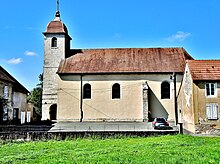
The current church of Saint-Léger was built in 1739 in the classical style.
population
| Population development | |
|---|---|
| year | Residents |
| 1962 | 364 |
| 1968 | 405 |
| 1975 | 469 |
| 1982 | 518 |
| 1990 | 474 |
| 1999 | 450 |
| 2005 | 398 |
| 2016 | 421 |
With 418 inhabitants (as of January 1, 2017) Rang is one of the small communities in the Doubs department. After the population in the first half of the 20th century had always been in the range between 330 and 390 people, a significant increase in population was recorded, especially during the 1970s. After peaking at the beginning of the 1980s, a downward trend began that continues to this day.
Economy and Infrastructure
Rank was a village dominated by agriculture (arable farming, fruit growing and animal husbandry) and forestry until well into the 20th century. In addition, there are now some local small businesses. A commercial and industrial zone was created on the outskirts, in which companies from the automotive industry and the manufacture of tension belts and chains have settled. In the meantime, the village has also turned into a residential community. Many workers are therefore commuters who work in the larger towns in the area.
The village is well developed in terms of traffic. It is on the main road N83, which leads from Besançon to Montbéliard. The nearest connection to the A36 motorway , which crosses the municipality, is around four kilometers away. Another road connection is with Saint-Georges-Armont. Rank owns a station on the Dole – Besançon – Belfort railway line , which is no longer served.

