Warder (Rendsburg-Eckernförde district)
| coat of arms | Germany map | |
|---|---|---|

|
Coordinates: 54 ° 13 ' N , 9 ° 53' E |
|
| Basic data | ||
| State : | Schleswig-Holstein | |
| Circle : | Rendsburg-Eckernförde | |
| Office : | Nortorfer Land | |
| Height : | 28 m above sea level NHN | |
| Area : | 8.71 km 2 | |
| Residents: | 685 (Dec. 31, 2019) | |
| Population density : | 79 inhabitants per km 2 | |
| Postal code : | 24646 | |
| Primaries : | 04329, 04392 | |
| License plate : | RD, ECK | |
| Community key : | 01 0 58 168 | |
| Office administration address: | Niedernstrasse 6 24646 Nortorf |
|
| Website : | ||
| Mayor : | Elke Stahl (BfW) | |
| Location of the municipality Warder in the Rendsburg-Eckernförde district | ||
Warder is a municipality in the Rendsburg-Eckernförde district in Schleswig-Holstein . Alt Mühlendorf and Seehof are in the municipality.
Geography and traffic
Warder is located about 15 km north of Neumünster , 17 km southeast of Rendsburg and 19 km southwest of Kiel in the Westensee Nature Park . The federal highway 7 from Neumünster to Rendsburg runs through the municipality.
The community lies on the Wardersee and the Brahmsee . There are extensive weekend home areas on both lakes.
history
There were several megalithic tombs in Warder, but in the past the stones were crushed and used to build houses.
Warder originally consisted of two separate settlements, which were mentioned in 1442 as Grotenwerdere and Lutkenwerder. However, the village of Lutkenwerder was probably abandoned in the 16th century and its exact location is unknown today.
It is assumed that Alt-Mühlendorf has had a water mill at least since the first mention of the place in 1271. Initially, the Alt-Mühlendorf watermill was used as a grain and tar mill, today it is used to generate electricity from hydropower. Lohe was obtained from oak bark and used to tan leather.
Warder was honored in the competition Our village should be more beautiful .
politics
Community representation
Since the local elections in 2013, only the community of voters "General voter community - Citizens for Warder" (AW-BfW) has stood and provides all nine members of the community council and the mayor.
coat of arms
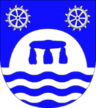
Blazon : “Above blue-silver waves in blue, a silver hill covered with a blue stone grave. A seven-spoke silver mill wheel in each of the upper corners. "
economy
The community is predominantly agricultural. But tourism and local recreation have also become important sources of income. Warder has had a hatchery since 1877.
Attractions
The list of cultural monuments in Warder (Rendsburg-Eckernförde district) includes the cultural monuments entered in the list of monuments of Schleswig-Holstein.
- Arche Warder animal park, animal park for rare farm animal breeds
- Stone park Warder by the sculptor Ben Siebenrock
Web links
Individual evidence
- ↑ North Statistics Office - Population of the municipalities in Schleswig-Holstein 4th quarter 2019 (XLSX file) (update based on the 2011 census) ( help on this ).
- ^ Warder community council
- ↑ Schleswig-Holstein topography. Vol. 10: Timmaspe - Ziethen . 1st edition Flying-Kiwi-Verl. Junge, Flensburg 2008, ISBN 978-3-926055-92-7 , p. 159 ( dnb.de [accessed on August 9, 2020]).
- ↑ The municipal coat of arms of Schleswig-Holstein speaks of the representation deviating from eight-spoke mill wheels


