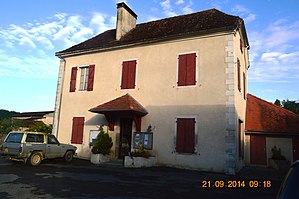
Abitain
| Abitain | ||
|---|---|---|
|
|
||
| region | Nouvelle-Aquitaine | |
| Department | Pyrénées-Atlantiques | |
| Arrondissement | Oloron-Sainte-Marie | |
| Canton | Orthez et Terres des Gaves et du Sel | |
| Community association | Bearn des Gaves | |
| Coordinates | 43 ° 25 ′ N , 0 ° 59 ′ W | |
| height | 28-136 m | |
| surface | 6.59 km 2 | |
| Residents | 102 (January 1, 2017) | |
| Population density | 15 inhabitants / km 2 | |
| Post Code | 64390 | |
| INSEE code | 64004 | |
| Website | http://www.annuaire-mairie.fr/mairie-abitain.html | |
 town hall |
||
Abitain is a French municipality with 102 inhabitants (at January 1, 2017) in the department of Pyrénées-Atlantiques in the region Nouvelle-Aquitaine (before 2016: Aquitaine ). It belongs to the Arrondissement of Oloron-Sainte-Marie and the Canton of Orthez et Terres des Gaves et du Sel (until 2015: Canton Sauveterre-de-Béarn ). The inhabitants are called Abitainois .
geography
Abitain is about 45 kilometers northwest of Oloron-Sainte-Marie and is part of the Lauhiere , a stretch of land between the Basque Country and the Béarn in the north of the department. Abitain is surrounded by the neighboring communities Escos and Labastide-Villefranche in the north, Athos-Aspis and Oraàs in the east, Autevielle-Saint-Martin-Bideren in the south and Ilharre in the west.
Abitain is located in the catchment area of the Adour River on the banks of the Gave d'Oloron at the mouth of the Arrioutèque tributary .
history
Because of its location on the Gave d'Oloron, Abitain emerged very early under Roman rule. The geographically advantageous location resulted in rapid growth. At the end of the Middle Ages, the settlement had a certain status, supported by agriculture and the establishment of several tanneries in the 13th century. The location on the river also led to the decision to build two flour mills in the 17th and 18th centuries on the left bank, called “de Leü”, of which only ruins remain, and “de Ségabache”, which is still a sawmill in Operation is.
The lay monastery , which was located in the middle of the village and was dependent on the vice-county of Béarn , owned a large number of feudal estates . The grave of the last abbot, who died in 1785, is in the local church. The monastery building was demolished in 1834. His stones were then used to build Escos Castle .
Population development
| year | 1968 | 1975 | 1982 | 1990 | 1999 | 2008 | 2017 |
|---|---|---|---|---|---|---|---|
| Residents | 158 | 143 | 138 | 126 | 107 | 101 | 102 |
Attractions
- Catholic parish church of St-Pierre
- The Bellocq house, a 17th century building, is connected to the last owners of the monastery, the Bellocq (1676–1731). Despite remodeling, the house retained a cross-frame window from the 17th century.
Economy and Infrastructure
The economy is primarily determined by agriculture, so u. a. from growing vegetables, cereals and wine. Abitain is located in the AOC zones of Ossau-Iraty , a traditionally made semi-hard cheese made from sheep's milk, the pig breed and the ham "Kintoa".

total = 18
traffic
The Route départementale 936 (former Route nationale 636 ) flows through the village.
Web links
- Abitain and its sights (French)
- Website of the AOP Ossau-Iraty association (French)
- Filière Porc Basque website (French)
Individual evidence
- ↑ Pyrénées-Atlantiques Gentile ( fr ) habitant.fr. Retrieved December 19, 2016.
- ↑ a b c Abitain ( fr ) Visites en Aquitaine. Archived from the original on December 22, 2016. Retrieved on December 19, 2016.
- ↑ Notice Communale Abitain ( fr ) EHESS . Retrieved December 19, 2016.
- ↑ Populations légales 2013 Commune d'Abitain (64004) ( fr ) INSEE . Retrieved December 19, 2016.
- ↑ Institut national de l'origine et de la qualité: Rechercher un produit ( fr ) Institut national de l'origine et de la qualité . Retrieved October 5, 2017.
- ↑ http://www.insee.fr/fr/statistiques/2117503?geo=COM-64004 (link not available)


