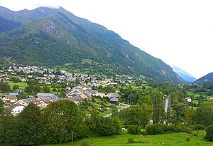
Laruns
| Laruns | ||
|---|---|---|

|
|
|
| region | Nouvelle-Aquitaine | |
| Department | Pyrénées-Atlantiques | |
| Arrondissement | Oloron-Sainte-Marie | |
| Canton | Oloron-Sainte-Marie-2 | |
| Community association | Vallée d'Ossau | |
| Coordinates | 42 ° 59 ′ N , 0 ° 26 ′ W | |
| height | 458-2,973 m | |
| surface | 248.96 km 2 | |
| Residents | 1,194 (January 1, 2017) | |
| Population density | 5 inhabitants / km 2 | |
| Post Code | 64440 | |
| INSEE code | 64320 | |
| Website | Laruns | |
 Laruns in the Vallée d'Ossau |
||
Laruns ( Gascon Laruntz ) is a place and one from the city and several villages (hamlets) existing community with 1,194 inhabitants (at January 1, 2017) in the department of Pyrénées-Atlantiques in the southwestern French region Nouvelle-Aquitaine . The municipality of Laruns is around 249 km² - after Arles and Saintes-Maries-de-la-Mer - one of the largest municipalities in southern France in terms of area.
Location and climate
The mountain and border town with 1194 inhabitants (as of January 1, 2017) is located in the Vallée d'Ossau in the Pyrenees National Park directly on the Spanish border at an altitude of 545 m . The cities of Pau and Tarbes are about 40 km north and 68 km northeast, respectively; the pilgrimage town of Lourdes is a good 50 km away. The Col d'Aubisque pass connects Laruns with the French community of Argelès-Gazost in the Gave de Pau valley ; the Col du Portalet leads to Spain. The climate is temperate; Rain (approx. 885 mm / year) falls over the year.
Population development
| year | 1800 | 1851 | 1901 | 1954 | 1999 | 2015 |
| Residents | 1,375 | 2,064 | 2,061 | 1,788 | 1,425 | 1,179 |
The mechanization of agriculture and the resulting loss of job opportunities caused a significant population decline in the 20th century.
economy
The community is largely agriculturally oriented, with livestock being of particular importance. Tourism has played an important role in the municipality's economic life since the 1960s.
history
The place name has been mentioned in documents since the 12th century; the mountain pass of the Col de Portalet , about 30 km to the south , was probably used earlier. In the hamlet (hameau) Gabas there was a hospital for pilgrims . Later Laruns belonged to the Baillage Ossau and was an important border town with Spain; the Caze de Brousset was a preferred border post, which was destroyed by Spanish border troops during the revolutionary years.
Attractions
- The place is visited today mainly because of its pleasant climate and the numerous hiking opportunities in its area. Experienced mountain hikers also climb the Pic du Midi d'Ossau, approx. 20 km south .
- The Eglise de l'Assomption-de-la-Bienheureuse-Vierge-Marie dates from the 17th century; it was modernized in the 19th century.
- The Eglise Saint-Pierre was built in the late 19th century on the site of a demolished late medieval church.
- A wash house ( lavoir ) is on the outskirts.
Sons and daughters of the church
- Pierre Eyt (1934–2001), Archbishop of Bordeaux, is buried in Laruns

