Arette
|
Arette Areta |
||
|---|---|---|

|
|
|
| region | Nouvelle-Aquitaine | |
| Department | Pyrénées-Atlantiques | |
| Arrondissement | Oloron-Sainte-Marie | |
| Canton | Oloron-Sainte-Marie-1 | |
| Community association | Haut Bearn | |
| Coordinates | 43 ° 6 ′ N , 0 ° 43 ′ W | |
| height | 292-2,315 m | |
| surface | 92.23 km 2 | |
| Residents | 1,057 (January 1, 2017) | |
| Population density | 11 inhabitants / km 2 | |
| Post Code | 64570 | |
| INSEE code | 64040 | |
 Town Hall (Mairie) of Arette |
||
Arette ( Occitan : Areta ) is a French municipality with 1057 inhabitants (as of January 1 2017) in the department of Pyrénées-Atlantiques in the region Nouvelle-Aquitaine . It belongs to the Arrondissement of Oloron-Sainte-Marie and the Canton of Oloron-Sainte-Marie-1 (until 2015: Canton Aramits ). The inhabitants are called Arettois .
geography
Arette is about 36 kilometers southwest of Pau on the border with Spain . Arette is surrounded by the neighboring communities of Aramits in the north, Issor in the northeast, Lourdios-Ichère and Osse-en-Aspe in the east, Lées-Athas in the southeast, Isaba (Spain), Sainte-Engrâce in the southwest and Lanne-en-Barétous in the west .
history
In an earthquake in 1967 the village was almost completely destroyed.
Population development
| year | 1962 | 1968 | 1975 | 1982 | 1990 | 1999 | 2006 | 2013 |
| Residents | 1,189 | 1,055 | 1.166 | 1,117 | 1,137 | 1,094 | 1,092 | 1,045 |
| Source: Cassini and INSEE | ||||||||
Attractions
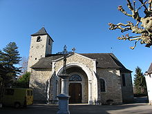
- Saint-Just Church
- 17th century monastery, monument historique since 1968
Community partnerships
There has been a partnership with the Spanish municipality of Isaba in the Basque Country since 1977, and in 2012 Arette entered into a cooperation with the Spanish municipality of Roncal .

