
Etsaut
|
Etsaut Eth Saut |
||
|---|---|---|
.svg)
|
|
|
| region | Nouvelle-Aquitaine | |
| Department | Pyrénées-Atlantiques | |
| Arrondissement | Oloron-Sainte-Marie | |
| Canton | Oloron-Sainte-Marie-1 | |
| Community association | Haut Bearn | |
| Coordinates | 42 ° 55 ′ N , 0 ° 34 ′ W | |
| height | 560-2,606 m | |
| surface | 34.95 km 2 | |
| Residents | 69 (January 1, 2017) | |
| Population density | 2 inhabitants / km 2 | |
| Post Code | 64490 | |
| INSEE code | 64223 | |
 View of Etsaut |
||

Etsaut is a French municipality with 69 inhabitants (at January 1, 2017) in the department of Pyrénées-Atlantiques in the region Nouvelle-Aquitaine (before 2016: Aquitaine ). It belongs to the Arrondissement of Oloron-Sainte-Marie and the Canton of Oloron-Sainte-Marie-1 (until 2015: Canton of Accous ).
The inhabitants are called Etsautois and Etsautoises or Etsautais and Etsautaises .
geography
Etsaut is about 40 km south of Oloron-Sainte-Marie in the Aspetal , one of the three valleys of the Hoch– Béarn .
The highest point in the municipality is the Escarpu ( 2606 m ).
The place is surrounded by the neighboring communities:
| Cette-Eygun | ||
| Borce |
.svg)
|
Laruns |
| Urdos |
Etsaut lies in the catchment area of the Adour River .
Tributaries of the Gave d'Aspe cross the municipality:
- the Sescoué with its tributaries
- Ruisseau de Pétraube,
- Le Pour-Mourt and
- Ruisseau de l'Esterous,
- the Ruisseau de Bouscagne,
- the Ruisseau de Sadum with its tributary
- Ruisseau de Yèse,
- the Ruisseau de Lucharry.
history
Several barrows attest to the first settlement in prehistory . The community remained isolated from the outside world for a long time because there was no access road until the 18th century. Nevertheless, 43 households were counted in the census in 1385, including some from Cagot families , members of a group of people who were discriminated against in Spain and France from the 13th to well into the 19th century and largely excluded from social life. The community also had to have a certain importance, as a special tax was levied on merchants from Aragon for the maintenance of the roads in the valley. In the Second World War became Etsaut a certain notoriety, were held as prominent French politician in Fort du Portalet in prison before being deported to Germany. After the liberation of France in 1945, Philippe Pétain , head of state of the former Vichy regime collaborating with Germany , was also briefly housed in this fort.
Toponyms and mentions of Etsaut were:
- Etsaut (1250, for d'Aspe, manuscript from the 14th century),
- Atsaut (around 1360, register from Came ),
- Adsaut (1385, census of the Béarn),
- Atssaut (1397, notaries of Navarrenx ) and
- Sent Grat deu Saut (1620, publications by the Diocese of Oloron )
Population development
| year | 1962 | 1968 | 1975 | 1982 | 1990 | 1999 | 2006 | 2009 | 2017 |
|---|---|---|---|---|---|---|---|---|---|
| Residents | 158 | 141 | 125 | 104 | 92 | 105 | 84 | 78 | 69 |

Attractions


- Parish church dedicated to Saint Gratus, the first bishop of the Oloron diocese , who was also in Etsaut. The entrance portal under the bell tower dates from the 18th century. This massive tower is covered with a tent roof and shows in its outer facade two niches with statuettes , one depicting St. Joseph , the other the St. Germana cousin. The church was rebuilt in the 19th century and the long building today shows a nave , a polygonal apse and a side chapel , which is dedicated to Mary, the mother of Jesus .
- Solid house of Etsaut. With its thick limestone walls , the tower was built in the 14th century and was intended to offer the villagers protection from external threats. For this purpose it originally did not have an entrance door. 14 arches are distributed over the facade, especially on the level of the first floor. This was originally uninhabited, not least due to the lack of windows, until window openings were broken into the walls in the 16th century. The second floor was intended as a living area from the start, while the third and top floor was never inhabited. An engraving from 1881 shows the building still without the current half-hip roof . On the north side, a residential building has been added to replace a building from the construction period of the tower, because the connection to the tower is still made today via doors on the ground floor and on the first floor.
- Away you Portalet. The beginnings of the earlier fort date back to the 16th century as a customs post at an altitude of ( 765 m ) on a steep rock face high above the Gave d'Aspe. Alfred de Vigny , a French writer , wrote several poems there in 1823 . Today's fort was built on the instructions of King Louis-Philippe I between 1840 and 1860 to protect the road to Somport and to defend against a possible Spanish invasion. A barracks for soldiers and a pavilion for officers were set up on two floors at a height difference of 150 m . By 1925, the plant was of a regiment of infantry occupied. Subsequently, a colonie de vacances , a holiday facility for children and young people, moved into the fort. During the Second World War , a German garrison took over the site as part of the occupation of the unoccupied zone of France and simultaneously took over prominent French politicians imprisoned there, such as B. Léon Blum , Paul Reynaud , Georges Mandel , Édouard Daladier or Maurice Gamelin . They were convicted by the Vichy regime in the Riom trial and were then extradited to the Germans. After the liberation of France in 1945, the initiator of the Riom trial, Philippe Pétain himself, was sentenced to life imprisonment and also briefly housed in this fort. The Communauté de communes de la Vallée d'Aspe is now the owner of the facility, which is open to visitors on certain days of the year.
- House of the bear. Edward I , King of England , and his wife Eleanor of Castile were on their way to Spain to meet Alfonso III. , King of Aragon, and stayed in this house in 1289, which at the time belonged to the family of Jean d'Arudy, a cousin of Eleanor. Sanchot d'Arudy later headed the king's guard, after which the descendants were appointed noblemen and the house is one of the few that bears a coat of arms. In addition to a bear's head, the facade shows a cow and a lion as a bas-relief , reminiscent of the insignia of the English king. Today the building is a leisure center, with little of the medieval quarter to be seen. The facade dates from the 19th to 20th centuries and the roof has been enlarged.
- Memorial plaques of the Resistance . Immediately after the armistice of June 22, 1940 between Hitlerite Germany and France, resistance against the German occupiers was organized . Very active groups established themselves in southwest France, including the Corps Franc Pommiès , which was founded by André Pommiès, captain of the 18th Infantry Regiment in Pau . Up until the liberation in August 1944, numerous attacks were carried out in the region, supported by former fighters of the Spanish Civil War . When the fort du Portalet was liberated, René Lefebvre was fatally injured as a fighter in the Corps Franc Pommiès at the age of 32. In his memory and for the liberation of the Aspetal by the Corps Franc Pommiès , two plaques have been placed.
- Former Etsaut train station. The Pau – Canfranc railway line has been closed since 1970 between Bedous and Canfranc . The former train station in Etsaut is now home to the Pyrenees National Park . Permanent exhibits show the fauna of the Pyrenees all year round : bearded vultures , griffon vultures , wild boar , golden eagles , Pyrenees chamois and especially the brown bear . A nature trail has also been set up, with information boards in French, Spanish, Braille and capital letters for the visually impaired showing more than 25 tree species , as well as prints of the tracks of wild animals.
Economy and Infrastructure

Agriculture and tourism are important economic factors in the municipality. Etsaut is in the AOC zone of Ossau-Iraty , a traditionally made cheese made from sheep's milk.

total = 17
sport and freetime
The GR 10 long-distance hiking trail from Hendaye on the Atlantic to Banyuls-sur-Mer on the Mediterranean leads through the municipality.
Every year on the last Sunday in July there is a cheese festival, at which the shepherd's profession, the production of cheese and the different types of cheese from the summer pastures of the Aspetal itself are presented, whether cheese made from sheep's milk, cow's milk, goat's milk or mixed. Craftsmen and producers of other agricultural products, singing and dancing complete the festival.
The Chemin de la mâture hiking trail is 1.2 km long and leads over a path carved into the rock high above the Sescoué valley. a. also got a view from above of the Fort du Portalet. The French King Louis XIV and his naval and finance minister Jean-Baptiste Colbert decided in the 17th century to set up a navy. To do this, they needed tall trees, as can be found in the Aspetal. In order to be able to transport the trees away, Etsaut was finally connected to the road network and a transport route to the forest of Pacq was laid between the communities of Etsaut and Urdos. Above the gorge de l'Enfer , a 4 m wide path, the width of a team of oxen, was carved into the rock. A century later, around 1778, the wood stock was exhausted and it took another hundred years for the forest to recover.
- Chemin de la Mâture


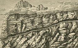
Chemin de la Mâture 1781
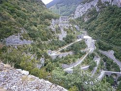
View of the Fort du Portalet


.jpg)

education
Etsaut has a public primary school.
traffic
The municipality is connected to the national route 134 .
As a replacement for the disused Pau – Canfranc railway line , a TER Aquitaine bus line , a regional train operated by the state-owned SNCF , connects the municipality several times a day with Canfranc and Bedous with a connection to the TER Aquitaine regional railway line 63 to Pau via Oloron-Sainte-Marie.
Web links
- Etsaut on the website of the Tourist Office of the Association of Municipalities (French)
- Etsaut on the website of the former community association (French)
- Site of the Pyrenees National Park
- TER Aquitaine website (French)
- Website of the AOP Ossau-Iraty association (French)
Individual evidence
- ↑ Pyrénées-Atlantiques Gentile ( fr ) habitant.fr. Retrieved May 25, 2017.
- ↑ géoportail - Etsaut ( fr ) Institut national de l'information geographique et forestière . Retrieved May 25, 2017.
- ↑ Ma commune: Etsaut ( fr ) Système d'Information sur l'Eau du Bassin Adour Garonne. Retrieved May 25, 2017.
- ↑ Regional Council of Aquitaine: Etsaut ( fr ) Visites en Aquitaine. Archived from the original on September 9, 2016. Info: The archive link was inserted automatically and has not yet been checked. Please check the original and archive link according to the instructions and then remove this notice. Retrieved May 25, 2017.
- ^ A b Paul Raymond: Dictionnaire topographique du département des Basses-Pyrénées ( fr ) In: Dictionnaire topographique de la France . Imprimerie nationale. P. 63, 1863. Retrieved May 25, 2017.
- ↑ Notice Communale Etsaut ( fr ) EHESS . Retrieved May 25, 2017.
- ↑ Populations légales 2006 Commune d'Etsaut (64223) ( fr ) INSEE . Retrieved May 26, 2017.
- ↑ Populations légales 2014 Commune d'Etsaut (64223) ( fr ) INSEE . Retrieved May 25, 2017.
- ↑ Église Saint-Grat ( fr ) Visites en Aquitaine. Retrieved on May 25, 2017. ( Page no longer available , search in web archives ) Info: The link was automatically marked as defective. Please check the link according to the instructions and then remove this notice.
- ↑ Maison forte d'Etsaut ( fr ) Visites en Aquitaine. Retrieved on May 25, 2017. ( Page no longer available , search in web archives ) Info: The link was automatically marked as defective. Please check the link according to the instructions and then remove this notice.
- ↑ maison forte ( fr ) Ministry of Culture and Communication . Retrieved May 25, 2017.
- ^ Conseil regional d'Aquitaine: Fort du Portalet ( fr ) Visites en Aquitaine. Archived from the original on March 12, 2017. Info: The archive link was inserted automatically and has not yet been checked. Please check the original and archive link according to the instructions and then remove this notice. Retrieved May 25, 2017.
- ^ Ensemble fortifié du Portalet (également sur commune de Borce) ( fr ) Ministry of Culture and Communication . Retrieved May 25, 2017.
- ↑ Regional Council of Aquitaine: Maison de l'Ours ( fr ) Visites en Aquitaine. Retrieved on May 25, 2017. ( Page no longer available , search in web archives ) Info: The link was automatically marked as defective. Please check the link according to the instructions and then remove this notice.
- ↑ Conseil régional d'Aquitaine: Corps Franc Pommiès ( fr ) Visites en Aquitaine. Retrieved on May 25, 2017. ( Page no longer available , search in web archives ) Info: The link was automatically marked as defective. Please check the link according to the instructions and then remove this notice.
- ↑ Conseil régional d'Aquitaine: Stèle à la mémoire de René Lefebvre ( fr ) Visites en Aquitaine. Retrieved on May 25, 2017. ( Page no longer available , search in web archives ) Info: The link was automatically marked as defective. Please check the link according to the instructions and then remove this notice.
- ↑ Maison du Parc national à Etsaut ( fr ) Pyrenees National Park. Retrieved May 25, 2017.
- ↑ Institut national de l'origine et de la qualité ( fr ) Institut national de l'origine et de la qualité . Retrieved May 25, 2017.
- ↑ Caractéristiques des établissements en 2014 Commune d'Etsaut (64223) ( fr ) INSEE . Retrieved on May 25, 2017. ( Page no longer available , search in web archives ) Info: The link was automatically marked as defective. Please check the link according to the instructions and then remove this notice.
- ↑ GR®10: la traversée des Pyrénées ( fr ) Comité Régional de la Randonnée Pédestre Midi-Pyrénées. Retrieved May 25, 2017.
- ↑ La fête du fromage d'Etsaut ( fr ) Offices de Tourisme des Pyrénées Béarnaises. Retrieved May 25, 2017.
- ↑ Regional Council of Aquitaine: Chemin de la mâture ( fr ) Visites en Aquitaine. Retrieved on May 25, 2017. ( Page no longer available , search in web archives ) Info: The link was automatically marked as defective. Please check the link according to the instructions and then remove this notice.
- ^ École élémentaire ( fr ) National Ministry of Education. Retrieved May 25, 2017.