
Castet
|
Castet Casteth |
||
|---|---|---|
|
||
| region | Nouvelle-Aquitaine | |
| Department | Pyrénées-Atlantiques | |
| Arrondissement | Oloron-Sainte-Marie | |
| Canton | Oloron-Sainte-Marie-2 | |
| Community association | Vallée d'Ossau | |
| Coordinates | 43 ° 4 ′ N , 0 ° 25 ′ W | |
| height | 419–2,020 m | |
| surface | 23.53 km 2 | |
| Residents | 157 (January 1, 2017) | |
| Population density | 7 inhabitants / km 2 | |
| Post Code | 64260 | |
| INSEE code | 64175 | |
| Website | http://www.castet.fr/ | |

Castet ( Occitan : Casteth ) is a French municipality with 157 inhabitants (as of January 1 2017) in the department of Pyrénées-Atlantiques in the region Nouvelle-Aquitaine (before 2016: Aquitaine ). It belongs to the canton of Oloron-Sainte-Marie-2 (until 2015: Canton of Arudy ) in the Arrondissement of Oloron-Sainte-Marie .
geography
Castet is located about 25 kilometers south-southwest of Pau in the Pyrenees National Park in the Vallée d'Ossau on the Gave d'Ossau , which is dammed up here to form the Lac de Castet . Castet is surrounded by the neighboring communities Louvie-Juzon in the north and east, Louvie-Soubiron in the south and south-east, Aste-Béon in the south and south-west and Bielle in the west.
Population development
| year | 1962 | 1968 | 1975 | 1982 | 1990 | 1999 | 2006 | 2013 |
| Residents | 255 | 241 | 189 | 189 | 157 | 155 | 159 | 158 |
| Source: Cassini and INSEE | ||||||||
Attractions

High altar
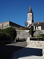
Saint-Polycarpe Church


- Saint-Polycarpe church from the 11th century, renovations from the 15th / 16th centuries. century
- Sainte-Catherine church from the 15th century