
Sainte-Colome
| Sainte-Colome | ||
|---|---|---|
|
||
| region | Nouvelle-Aquitaine | |
| Department | Pyrénées-Atlantiques | |
| Arrondissement | Oloron-Sainte-Marie | |
| Canton | Oloron-Sainte-Marie-2 | |
| Community association | Vallée d'Ossau | |
| Coordinates | 43 ° 6 ′ N , 0 ° 24 ′ W | |
| height | 347-618 m | |
| surface | 9.35 km 2 | |
| Residents | 356 (January 1, 2017) | |
| Population density | 38 inhabitants / km 2 | |
| Post Code | 64260 | |
| INSEE code | 64473 | |
 Parish Church of Saint-Sylvestre |
||

Sainte-Colome is a French municipality with 356 inhabitants (at January 1, 2017) in the department of Pyrénées-Atlantiques in the region Nouvelle-Aquitaine (before 2016: Aquitaine ). The municipality belongs to the arrondissement of Oloron-Sainte-Marie and the canton of Oloron-Sainte-Marie-2 (until 2015: Canton Arudy ).
The name in the Gascognic language is Senta Coloma . It is derived from the holy Kolumba of Sens ( French sainte Colombe ). The inhabitants are called Saint-Colomois and Saint-Colomoises .
geography
Sainte-Colome is located about 20 km southeast of Oloron-Sainte-Marie in the Ossau Valley in the historic province of Béarn .
The place is surrounded by the neighboring communities:
| Sévignacq-Meyracq | Lys | |
.svg)
|
||
| Louvie-Juzon |
The highest point in the municipality is the Pouey Agut ( 618 m ) on the border with the neighboring municipality of Sévignacq-Meyracq.
Sainte-Colome is located in the catchment area of the Adour River . The Landistou, a tributary of the Béez , has its source in the commune. In addition, the Ruisseau d'Ombratiou, together with its tributary, the Ruisseau de la Fontaine de Mesplé, irrigates the municipality.


history
Grottoes in the area of the municipality show a settlement already in prehistory . In Gallo-Roman times , a Roman road ran through what is now Sainte-Colome. In the Middle Ages it was the Cami dou Senhou , the "Way of the Lord", that led pilgrims on their way to Santiago de Compostela . In 1385, Sainte-Colome was the most important place in the Ossau Valley with 91 houses that were counted in the census . The village belonged to the Bailliage of the Archdeaconate of Ossau. There was a lay monastery , vassal of the Viscount of Bearn. In the 12th and 13th centuries the strong position of the landlords was evident in punitive expeditions that they carried out against neighboring towns. In the 17th century, a plague epidemic devastated the village, which subsequently lost its importance.
In 1858 the municipality of Lys broke away from Sainte-Colome.
Toponyms and mentions of Sainte-Colome were:
- Sancta-Columba (around 1100, documents from Mifaget ),
- Sente-Colome (1277, copy book of Ossau or Livre rouge , sheet 3),
- Sanctus-Silvester de Sainte-Colome (1655, publications of the Diocese of Oloron ),
- Sainte Colome (1750 and 1793, map by Cassini or Notice Communale ),
- Sainte-Colome (1801, Bulletin des lois ) and
- Sainte-Colomme (1863, Dictionnaire topographique du département des Basses-Pyrénées).
Population development
After the split from Lys in the middle of the 19th century, the community had around 680 inhabitants. In the following decades, with brief phases of recovery, the size fell to around 260 inhabitants by the 1980s. Since then there has been a slight upward trend.
| year | 1962 | 1968 | 1975 | 1982 | 1990 | 1999 | 2006 | 2009 | 2017 |
|---|---|---|---|---|---|---|---|---|---|
| Residents | 322 | 280 | 284 | 256 | 283 | 268 | 326 | 355 | 356 |

Attractions


- Parish church dedicated to Holy New Year's Eve . Work on its construction began, presumably on the site of an earlier church, in the 15th century and was completed in 1520. It is equipped with a massive, square bell tower that is reminiscent of a donjon . The single nave nave is extended with a five-walled apse and is framed by two side chapels . A late Gothic entrance portal extends under the porch on the south side . It is applied to a masonry bond with irregular but well-hewn sandstone blocks . The bars are made from segments with bulges and fillets , some with a touch of polychromy . The tympanum above the lower segment arch is filled with tracery and has a niche in the middle in which a statue of the Virgin Mary is attached. Above the archivolts , which form a pointed arch , the portal is provided with a keel arch , the eyelashes of which are decorated with crabs in the form of cabbage leaves. Below the top of the gable of the keel arch, two angels hold a coat of arms with three doves. The portal is framed by two pinnacles and a cornice , which are decorated with festoons . The vault inside the church consists of simple pointed arches, the keystones of which are provided with symbols and representations of religious people, such as B. St. Barbara , St. Kolumba or the Trinity . Since July 12, 2001, the church and its furnishings have been classified as a monument historique .
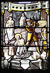
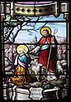
- Stained glass window of the parish church of Sainte-Colome

Peter and Paul
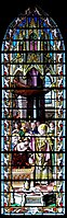
Baptism of Emperor Constantine the Great on Holy New Year's Eve

Appearance of the Immaculate Conception to Bernadette Soubirous


Germanus blesses the poor
Beheading of John the Baptist

Soul scales by the Archangel Michael
Jesus gives the keys to Peter

A bear protects holy Kolumba from rape

Death of St. Joseph


- Castle of Sainte-Colome. It was built as a permanent house in the 13th or early 14th century on a small rock ledge. During the Huguenot Wars , it was captured and set on fire by Protestant troops led by Gabriel de Lorges , Count of Montgomery. The building does not seem to have recovered from this event. The residential building measured 9 m × 12 m and had two floors. The roof rack and the slate roof collapsed today. More recent damage can be seen on the west and east facades in the form of large bulges. On the other hand, the residential building is flanked to the north by a square tower that dates from the 13th century. The north-western tower with a side length of three meters is only about twelve meters high. A twin window has been preserved on its first floor . The cladding of the outer walls was carried out with a medium, even masonry bond, the inner walls with a bed of broken pebbles, partly laid in a herringbone pattern . The stones on the corners of the wall and the frames of windows and doors are made of square limestone with a gray hue. Remains of the curtain wall and the wall along the entrance to the castle can still be seen. The castle, the Zwinger and the curtain wall have been classified as Monument historique since April 29, 1999 . Nevertheless, the site cannot be visited.
- Calvary of Boilä. It consists of three Latin crosses made of wood, without any decoration, which are rammed into the ground and are a direct reminder of the crucifixion of Christ and the two thieves . The location on a hill gives the crosses great visibility.
Economy and Infrastructure
.jpg)
The municipality's economy focuses on agriculture and services. There are marble quarries in the municipality, but they are closed today.
Sainte-Colome is in the AOC area of Ossau-Iraty , a traditionally made semi-hard cheese made from sheep's milk.

total = 35
education
The community has a public primary school with 18 students in the 2017/2018 school year.
sport and freetime
- The GR 78 long-distance hiking trail from Carcassonne to Saint-Jean-Pied-de-Port runs through the center of the municipality. It follows a byway of the Camino de Santiago to Santiago de Compostela .
- The long-distance hiking trail GR 108 "Chemin d'Ossau" to the Col des Moines or Col de Peyrelue starts in Sainte-Colome and Arudy .
- An easy circular route with a length of 6.4 km and a difference in altitude of 300 m leads from the center through the area of the municipality.
- The easy circular route "Les trois croix" with a length of 4.6 km and a difference in altitude of 210 m leads over fields and forests from Sainte-Colome to Sévignacq-Meyracq and back. He happens u. a. the Calvary of Sainte-Colome.
- An easy circular route for cyclists with a length of 8.2 km and a difference in altitude of 343 m leads from the center through the area of the municipality to Louvie-Juzon and back.
traffic
Sainte-Colome is crossed by Routes départementales 232 and 287.
Web links
- Atlas du Patrimoine Historique et Culturel with pictures from Sainte-Colome (French)
- Sainte-Colome on the website of the Tourist Office of the Association of Municipalities (French)
- Sainte-Colome on the website of the Pyrénées Béarnaises Tourist Office (French)
- Website of the AOP Ossau-Iraty association (French)
Individual evidence
- ↑ Sainte-Colome ( fr ) Gasconha.com. Retrieved November 21, 2017.
- ↑ a b Sainte-Colome ( fr ) visites.aquitaine.fr. Archived from the original on December 1, 2017. Info: The archive link was automatically inserted and has not yet been checked. Please check the original and archive link according to the instructions and then remove this notice. Retrieved November 21, 2017.
- ↑ géoportail - Sainte-Colome ( fr ) Institut national de l'information geographique et forestière . Retrieved November 21, 2017.
- ↑ Ma commune: Sainte-Colome ( fr ) Système d'Information sur l'Eau du Bassin Adour Garonne. Retrieved November 21, 2017.
- ^ A b Paul Raymond: Dictionnaire topographique du département des Basses-Pyrénées ( fr ) In: Dictionnaire topographique de la France . Imprimerie nationale. 146, 1863. Retrieved November 21, 2017.
- ↑ a b c Notice Communale Sainte-Colome ( fr ) EHESS . Retrieved November 21, 2017.
- ^ David Rumsey Historical Map Collection France 1750 ( en ) David Rumsey Map Collection: Cartography Associates. Retrieved November 21, 2017.
- ↑ Populations légales 2006 Commune de Sainte-Colome (64473) ( fr ) INSEE . Retrieved November 21, 2017.
- ↑ Populations légales 2014 Commune de Sainte-Colome (64473) ( fr ) INSEE . Retrieved November 21, 2017.
- ↑ Église Saint-Sylvestre ( fr ) visites.aquitaine.fr. Archived from the original on December 1, 2017. Info: The archive link was automatically inserted and has not yet been checked. Please check the original and archive link according to the instructions and then remove this notice. Retrieved November 21, 2017.
- ↑ Portail de l'église Saint-Sylvestre ( fr ) visites.aquitaine.fr. Archived from the original on December 1, 2017. Info: The archive link was automatically inserted and has not yet been checked. Please check the original and archive link according to the instructions and then remove this notice. Retrieved November 14, 2017.
- ^ Eglise Saint-Sylvestre ( fr ) Ministry of Culture and Communication . Retrieved November 21, 2017.
- ↑ Château de Sainte-Colome ( fr ) visites.aquitaine.fr. Archived from the original on December 1, 2017. Info: The archive link was automatically inserted and has not yet been checked. Please check the original and archive link according to the instructions and then remove this notice. Retrieved November 21, 2017.
- ^ Château de Sainte-Colome ( fr ) Ministry of Culture and Communication . Retrieved November 21, 2017.
- ↑ Calvaire de Boilä ( fr ) visites.aquitaine.fr. Archived from the original on December 1, 2017. Info: The archive link was automatically inserted and has not yet been checked. Please check the original and archive link according to the instructions and then remove this notice. Retrieved November 21, 2017.
- ↑ Institut national de l'origine et de la qualité ( fr ) Institut national de l'origine et de la qualité . Retrieved November 21, 2017.
- ↑ Caractéristiques des établissements en 2015 Commune de Sainte-Colome (64473) ( fr ) INSEE . Retrieved November 21, 2017.
- ^ École élémentaire ( fr ) National Ministry of Education. Retrieved November 21, 2017.
- ↑ GR®78: le chemin du piémont pyrénéen ( fr ) Comité Régional de la Randonnée Pédestre Midi-Pyrénées. Retrieved November 21, 2017.
- ↑ Les GR® 108 et 108 A - Le chemin d'Ossau ( fr ) Comité départemental de la Randonnée pédestre des Pyrénées-Atlantiques (CDRP 64). Retrieved November 21, 2017.
- ↑ Circuit n ° 15: Les buis ( fr , PDF) Tourist Office of the Association of Municipalities. Retrieved November 21, 2017.
- ↑ Circuit n ° 3: Les trois croix ( fr , PDF) Tourist office of the municipal association. Retrieved November 21, 2017.
- ↑ Circuit n ° 5: Boucle de la Tourbière ( fr , PDF) Tourist Office of the Association of Municipalities. Retrieved November 21, 2017.