Ainharp
|
Ainharp Ainharbe |
||
|---|---|---|
|
|
||
| region | Nouvelle-Aquitaine | |
| Department | Pyrénées-Atlantiques | |
| Arrondissement | Oloron-Sainte-Marie | |
| Canton | Montagne Basque | |
| Community association | Pays Basque | |
| Coordinates | 43 ° 16 ′ N , 0 ° 56 ′ W | |
| height | 129-426 m | |
| surface | 14.07 km 2 | |
| Residents | 141 (January 1, 2017) | |
| Population density | 10 inhabitants / km 2 | |
| Post Code | 64130 | |
| INSEE code | 64012 | |
 town hall |
||
Ainharp is a French municipality with 141 inhabitants (at January 1, 2017) in the department of Pyrénées-Atlantiques in the region Nouvelle-Aquitaine . The municipality belongs to the arrondissement of Oloron-Sainte-Marie and the canton of Montagne Basque (until 2015: canton of Mauléon-Licharre ).
The inhabitants are called Ainharbars . The name in the Basque language is Ainharbe .
geography
Ainharp is about 40 kilometers west of Oloron-Sainte-Marie in the French part of the Basque Country . The place is part of the historical region of Soule , one of the three historical territories. Ainharp is surrounded by the neighboring communities of Aroue-Ithorots-Olhaïby in the north, Espès-Undurein and Viodos-Abense-de-Bas in the east, Mauléon-Licharre in the south-east, Garindein and Ordiarp in the south and Lohitzun-Oyhercq in the north-west.
Ainharp lies in the catchment area of the Adour River and is crossed by numerous streams, u. a. the Lafaure and the Borlaas , which flow into the season , and the Quihilliri , a tributary of the Bidouze .
history
The village lies on a byway of the Way of St. James to Santiago de Compostela and was known for its pilgrims' hostel . The former priory of the Diocese of Oloron was first mentioned in 1472 under the name Ayharp .
Population development
| year | 1968 | 1975 | 1982 | 1990 | 1999 | 2008 | 2013 |
|---|---|---|---|---|---|---|---|
| Residents | 194 | 186 | 181 | 161 | 142 | 151 | 138 |
Attractions
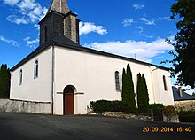
- The church, dedicated to John the Baptist , is one of the oldest in the Soule region. It was built in the Romanesque style during the Christianization of the Basque Country in the 11th century . Under the porch at the entrance five disc-shaped tombstones from the 17th century are placed as steles , which are often found in the other two Basque provinces of Labourd and Lower Navarra , but rarely in Soule. Such steles replaced traditional tombstones in the 16th and 17th centuries . The elements of their engraving can reveal something about the life of the dead.
- Since the village is on the Way of St. James, it is not surprising to find a calvary at the end of the village, here in the form of a stone cross.
Economy and Infrastructure
The economy is mainly determined by agriculture (sheep and cattle breeding and corn cultivation).
Ainharp is located in the AOC areas of Ossau-Iraty , a traditionally made semi-hard cheese made from sheep's milk, the pig breed and the ham "Kintoa".

total = 26
traffic
Ainharp is connected to Routes départementales 242 and 344.
Web links
- Website of the AOP Ossau-Iraty association (French)
- Filière Porc Basque website (French)
Individual evidence
- ↑ Pyrénées-Atlantiques Gentile ( fr ) habitant.fr. Retrieved December 27, 2016.
- ↑ Lieux - toponymie Ainharbe ( fr ) euskaltzaindia . Retrieved December 27, 2016.
- ↑ Ma commune: Ainharp ( fr ) Système d'Information sur l'Eau du Bassin Adour Garonne. Retrieved December 27, 2016.
- ↑ a b c d Ainharp ( fr ) Visites en Aquitaine. Archived from the original on December 27, 2016. Retrieved on December 27, 2016.
- ↑ Notice Communale Ainharp ( fr ) EHESS . Retrieved December 27, 2016.
- ↑ Populations légales 2013 Commune d 'Ainharp (64012) ( fr ) INSEE . Retrieved December 27, 2016.
- ↑ Institut national de l'origine et de la qualité ( fr ) Institut national de l'origine et de la qualité . Archived from the original on February 5, 2017. Retrieved February 5, 2017.
- ↑ http://www.insee.fr/fr/statistiques/2117503?geo=COM-64012 (link not available)


