Castetbon
| Castetbon | ||
|---|---|---|
|
|
||
| region | Nouvelle-Aquitaine | |
| Department | Pyrénées-Atlantiques | |
| Arrondissement | Oloron-Sainte-Marie | |
| Canton | Orthez et Terres des Gaves et du Sel | |
| Community association | Bearn des Gaves | |
| Coordinates | 43 ° 23 ′ N , 0 ° 47 ′ W | |
| height | 95-234 m | |
| surface | 14.2 km 2 | |
| Residents | 181 (January 1, 2017) | |
| Population density | 13 inhabitants / km 2 | |
| Post Code | 64190 | |
| INSEE code | 64176 | |
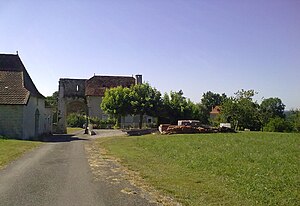
 View of Castetbon |
||
Castetbon is a French municipality with 181 inhabitants (as of January 1 2017) in the department of Pyrénées-Atlantiques in the region Nouvelle-Aquitaine . It belongs to the Arrondissement of Oloron-Sainte-Marie and the Canton of Orthez et Terres des Gaves et du Sel (until 2015: Canton Sauveterre-de-Béarn ).
geography
Castetbon is about 35 kilometers west-northwest of Pau . The Saleys forms part of the northern municipal boundary. Castetbon is surrounded by the neighboring communities of Ozenx-Montestrucq in the north and northwest, Loubieng in the north and northeast, Audaux in the south and east, Ossenx in the south, Narp in the south and southwest and Orriule in the west.
history
During the Middle Ages, one of the most important bridges on the road to Spain was located here. The medieval town center still bears witness to its importance at the time.
Population development
| year | 1962 | 1968 | 1975 | 1982 | 1990 | 1999 | 2006 | 2013 |
| Residents | 204 | 195 | 173 | 159 | 161 | 157 | 186 | 175 |
| Source: Cassini and INSEE | ||||||||
Attractions
- Notre-Dame de l'Assomption church
- earlier gate (so-called west gate or salt gate)

