
Bad Dürkheim
| coat of arms | Germany map | |
|---|---|---|

|
Coordinates: 49 ° 28 ' N , 8 ° 10' E |
|
| Basic data | ||
| State : | Rhineland-Palatinate | |
| County : | Bad Dürkheim | |
| Height : | 132 m above sea level NHN | |
| Area : | 102.67 km 2 | |
| Residents: | 18,575 (Dec. 31, 2019) | |
| Population density : | 181 inhabitants per km 2 | |
| Postal code : | 67098 | |
| Primaries : | 06322, 06329 (partly Jägerthal) | |
| License plate : | DÜW | |
| Community key : | 07 3 32 002 | |
| City structure: | 7 districts | |
City administration address : |
Mannheimer Strasse 24 67098 Bad Dürkheim |
|
| Website : | ||
| Mayor : | Christoph Glogger ( SPD ) | |
| Location of the city of Bad Dürkheim in the Bad Dürkheim district | ||
  |
||


Bad Dürkheim ( Palatinate : Derk (e) m , Därkem or Dergem ) is a spa and district town in the Rhine-Neckar metropolitan region on the edge of the Palatinate Forest in Rhineland-Palatinate . It is the administrative seat of the Bad Dürkheim district and, based on the number of inhabitants, its second largest local community. The city gained national fame through the Dürkheim sausage market and the Dürkheim giant barrel . According to state planning, Bad Dürkheim is designated as a medium-sized center.
geography
location
Bad Dürkheim is located on the Haardt , as the eastern edge of the central Palatinate Forest is called, on the German Wine Route , about 30 kilometers east of Kaiserslautern and just under 20 km west of Ludwigshafen and Mannheim . The district extends far into the Palatinate Forest and forms the so-called Limburg-Dürkheimer Wald southwest of the settlement area ; in the extreme north-west it includes areas of its sub-area Diemersteiner Wald . Neustadt an der Weinstrasse is about 15 kilometers south . To the northeast of Bad Dürkheim lies the Dürkheimer Bruch .
Neighboring communities are clockwise - including exclaves - Kallstadt , Freinsheim , Erpolzheim , Birkenheide , Ellerstadt , Gönnheim , Friedelsheim , Wachenheim an der Weinstrasse , Neidenfels , Weidenthal , Frankenstein , Fischbach (near Kaiserslautern) , Wattenheim , Neuleiningen , Kirchheim an der Weinstrasse , Bobenheim am Berg , Weisenheim am Berg , Herxheim am Berg , Weisenheim am Sand , Dackenheim and Altleiningen .
Surveys

There are several mountains of the Palatinate Forest in the district of Bad Dürkheim. Along its eastern edge there are peaks like the Ebersberg ( 342.1 m ). The Kleine Peterskopf ( 425.1 m ) and the Teufelsstein ( 317 m ) rise north of Grethen . The Weilerskopf ( 470 m ) lies on the border with a forest enclave in Herxheim am Berg . Immediately north of the city center and outside the Palatinate Forest is the 147.4 m high Michelsberg and south of it the 224 m high Fuchsmantel .
Further west lies with the 570.8 m measuring Drachenfels the highest elevation within the city district. Other mountains in this area are the Steinkopf ( 527 m ), the Hohekopf ( 507 m ), the Becherskopf ( 522 m ), the Engelskopf ( 441 m ), the Great Pfaffenkopf ( 486 m ), the Dreispitz ( 461 m ), the Stüterkopf ( 486 m ), the Stüterberg ( 364 m ) and on the border to an exclave belonging to Freinsheim the Rahnfels ( 517 m ). The 519 m high Seekopf and the 532 m high Plankenberg lie along the border with Wachenheim .
The 449 m high Krumme Eck and the 429 m high Spitzkopf and in the west the 403.5 m high Mainzer Berg extend in the far north-west of the district .
Waters


The Isenach flows through the city from west to east , a left tributary of the Rhine , which is also the city's central body of water. With the Isenachweiher, it has a reservoir near its source in the middle of the Palatinate Forest. The Erlengraben and the Albertgraben branch off from it in the northeast . Part of the Isenach river system is the Glashüttentalbach , which flows along its entire length through the city's forest area .
Several kilometers south of the Isenach, the Schwabenbach rises on the Bad Dürkheim forest area , which runs away from the buildings and reaches Wachenheim after a few kilometers. In the far west, the Glasbach , a left tributary of the Hochspeyerbach , forms the border to Frankenstein for a long distance. Its left tributary, the Erlenbach, has its source in the urban area, and after a kilometer it reaches the community of Frankenstein.
The Herzogweiher is located on the northern edge of Grethen . The Almensee is already in the Rhine plain northeast of the city . The Schlittgraben runs in the northeast for a few hundred meters over the city limits.
climate
574 mm of precipitation falls annually ; this is in the lower quarter of the values recorded in Germany, only 16% of the measuring stations of the German Weather Service register lower values. The driest month is February, with the highest rainfall in May, 1.6 times more than in February. Precipitation varies little and is very evenly distributed over the year, with only 1% of the measuring stations registering even lower seasonal fluctuations .
Districts

In addition to the core city, there are the incorporated districts of Grethen and Hardenburg to the west of it . The district of Grethen also includes the Hausen settlement and Hardenburg the Jägerthal . Seebach , which is located south of the city of origin, has now grown together structurally, as has the Trift district immediately east of the city center . In the northeast lies the district of Ungstein , which also includes the hamlet of Pfeffingen , and in the northwest is Leistadt .
history
Stone Age and Antiquity
Between 1200 and 500 BC the area around the eastern exit of the Isenach valley was populated by Celts . A Celtic hill settlement near the later Benedictine Abbey of Limburg and a second hill settlement on the northern side of the Isenach, the Heidenmauer , go back to them; In 1864, during the construction of the Rhein-Haardtbahn, a princess grave was discovered on the Heidenfeld and a burial mound field with 60 richly decorated graves on the Ebersberg. With a further five possible princely graves, these structures show the importance of the area at that time. Excavations are expected to provide further information on this Celtic center.
The Romans also left numerous evidence of their activities, for example the large Roman Weilberg winery in Bad Dürkheim-Ungstein with cemetery and manor house, with evidence of forerunners of the Riesling, Traminer and Burgundy vines that were already cultivated at that time. A few kilometers further south in Wachenheim a villa rustica was also found. The Roman quarry Kriemhildenstuhl is also important .
middle Ages
The place was first mentioned in a document on June 1, 778 - in the Lorsch Codex as "Turnesheim". In a feudal letter from the Bishop of Speyer from 946, "Thuringeheim" is mentioned.
The construction of the Limburg Benedictine Abbey began around 1025 and is now a ruined monastery. According to a document dated February 16, 1035, Emperor Konrad II gave the Dürkheim settlement to this newly founded monastery. It is said there that the monastery will receive the place "as property, with all rights and usufructs as the Rhine-Franconian dukes had since then".
Dürkheim's town charter, which was granted on January 1, 1360, was revoked in 1471 after Elector Friedrich the Victorious of the Palatinate had conquered the town and caused considerable damage. The gun master of the Electorate of the Palatinate, Martin Merz , was in charge of the bombardment.
Modern times


After the slow reconstruction, Dürkheim came to the Leiningen-Dagsburg line of the Counts of Leiningen in 1554 . In 1689, the place was almost completely destroyed when the French troops burned the Palatinate in the Palatinate War of Succession . This time it was rebuilt more quickly, so that Count Johann Friedrich von Leiningen granted city rights again as early as 1700. Count Friedrich Magnus von Leiningen-Dagsburg-Hardenburg (1703–1756) had the baroque Dürkheim Palace built as a residence on the northeast corner of the city from around 1720 and moved here in 1725. Dürkheim became a count's residence, and from 1779 a princely residence. The French burned the castle down in 1794 and only small remains of it exist. Today the Kurhaus and Kurpark-Hotel are located in its place .
The region was occupied by French revolutionary troops in the First Coalition War in 1794 and annexed to French territory in 1798. From 1798 to 1814, when the Palatinate was part of the French Republic (until 1804) and then part of the Napoleonic Empire , Dürckheim was - as the spelling at the time - the administrative seat of the canton of the same name in the Donnersberg department , to which 21 other municipalities belonged as well as the Mairie of the same name . In 1815 the place Austria was added. Then the place changed to the Kingdom of Bavaria . From 1818 to 1862 Dürkheim was part of the Neustadt Land Commissioner , which was then converted into a district office. Because of its seven healing springs, Dürkheim was given the addition of "brine bath" in 1847.
In 1902 Dürkheim became the seat of the newly created district office of Dürkheim , before this was reintegrated into its Neustadt counterpart in 1931. Since 1904 the city has been called "Bad Dürkheim". On March 31, 1935, Grethen, Hausen and Seebach were incorporated. From 1939 the city was part of the Neustadt district . On March 18, 1945 Bad Dürkheim was badly hit by an Allied air raid, killing over 300 people. After the war, the city became part of the then newly formed state of Rhineland-Palatinate within the French occupation zone .
In the course of the first administrative reform in Rhineland-Palatinate , on June 7, 1969, Hardenburg and Leistadt and on April 22, 1972 Ungstein and the hamlet of Pfeffingen were incorporated into Bad Dürkheim. In addition, the city became the administrative seat of the newly created district of Bad Dürkheim and was located in the newly formed administrative district of Rheinhessen-Pfalz , which lasted until 2000. Since October 21, 2010, the city has officially been a place of diversity .
population
Population development
In 1815 the city had fewer than 5000 inhabitants. In 1925 the number had risen to 7,060. The incorporation in the 20th century contributed to the fact that the population doubled in the following period.
religion
As of December 31, 2013, 38.7 percent of the population were Protestant , 24.7 percent Roman Catholic , 5.1 percent belonged to another religious community under public law and 31.5 percent were non-denominational.
- Christianity

The Michael's chapel, first attested in 1155, was the place of origin of the Dürkheim sausage market. The Evangelical Academy of the Palatinate , founded in 1951, was initially based in Bad Dürkheim. In the city area there was once the Schönfeld monastery , which was secularized together with the mother monastery Limburg during the early modern period; structural remains are no longer available.
On November 23, 2008, the Palatinate's first Protestant urn cemetery was inaugurated in the Seebach district of Bad Dürkheim. It is located directly at the monastery church. Only urns made of dissolving unfired earth are buried. The Landau sculptor Madeleine Dietz was commissioned with the artistic design . There was also a monastery of the same name in Seebach .
On the Catholic side, the city belongs to the Speyer diocese and is the seat of a deanery there . Since January 1, 2016 Bad Dürkheim has been the seat of the parish of St. Theresa of the Child Jesus , to which the St. Margaretha in Grethen and St. Michael in Leistadt branches within the city . The Church of St. Elisabeth in Hardenburg had already been profaned on May 27, 2013.
- Judaism
The Jewish community that once resided there owned a synagogue that was destroyed in an air raid in March 1945 during World War II. The Jews living there were subordinate to the District Rabbinate Dürkheim-Frankenthal ; the name of the latter came from the fact that the seat was in Frankenthal, but the district rabbi was resident there. On October 22, 1940, the Jews living in Bad Dürkheim were deported as part of the Wagner-Bürckel campaign .
politics
In federal elections, Bad Dürkheim has been part of the Neustadt - Speyer constituency since 1965 , and before that it was part of the Neustadt an der Weinstrasse constituency . In state elections, the city and most of the district have formed the constituency of Bad Dürkheim since 1991 .
City council
The city council of Bad Dürkheim consists of 32 honorary council members, who were elected in a personalized proportional representation in the local elections on May 26, 2019 , and the full-time mayor as chairman.
The distribution of seats in the city council:
| choice | SPD | CDU | FDP | GREEN | LEFT | REP | FWG | total |
|---|---|---|---|---|---|---|---|---|
| 2019 | 8th | 10 | 3 | 6th | - | - | 5 | 32 seats |
| 2014 | 9 | 14th | 2 | 3 | 1 | - | 3 | 32 seats |
| 2009 | 9 | 12 | 3 | 3 | 1 | 1 | 3 | 32 seats |
| 2004 | 9 | 14th | 2 | 2 | - | 2 | 3 | 32 seats |
- FWG = Free Voting Association Bad Dürkheim e. V.
In the city council, the SPD , the Greens and the FWG have formed a coalition since the local elections in 2019.
Before that, a so-called Jamaica coalition made up of the CDU , FDP and the Greens had ruled for 20 years . This made Bad Dürkheim one of the first cities in Germany to have this constellation in the council. The alliance of convenience was concluded in 1999 after the SPD lost its previous majority.
mayor
As the successor to Wolfgang Lutz (CDU), who had been in office for 16 years, Christoph Glogger (SPD) was elected mayor on July 12, 2015 with 52.83% of the vote. He won the runoff against the CDU applicant Gerd Ester. Well-known mayors of the past were Friedrich Dahlem , who was in office from 1921 to 1923 and from 1924 to 1933, Richard Imbt (NSDAP) from 1933 to 1936 and Anton Eberhard (FDP) from 1945 to 1946.
Town twinning
There are partnerships with Paray-le-Monial ( France ), Wells ( Great Britain ), Kreuzburg ( Poland ) and Kempten ( Germany ). The sponsorship with Bad Berka in Thuringia, which has existed since 1990, was upgraded to an official partnership in 2015 during the annual partnership meeting (with guests from all partner cities) on the occasion of the Dürkheim sausage market .
City friendships are cultivated with Michelstadt (Germany) and Emmaus ( USA ).
coat of arms
banner
|
|
Blazon : "A black wall anchor (door hinge) in silver." |
| Justification of the coat of arms: The coat of arms goes back to a court seal from 1405, which referred to the coat of arms of the Lords of Dürkheim . |
Sights and culture
Cultural monuments
- Monument zones

Limburg Benedictine Abbey

Hardenburg
Villa rustica on Weilberg


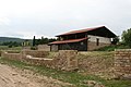
A total of 13 monument zones are designated within the city limits, including the ruins of the former Benedictine Abbey of Limburg on the edge of the Palatinate Forest . In the 9th century, the Salian dukes from Worms built a fortress on the Linthberg as the family seat of their family. At the beginning of the 11th century, the fortress was converted into a monastery with a basilica . It existed until the middle of the 16th century. The Hardenburg castle ruins extend above the district of the same name. It had been the seat of the Counts of Leiningen since the 13th century , but was only built in its current form in the 16th century. It was finally destroyed at the end of the 18th century. The castle Schlosseck originated in the tenth century and was inhabited until the 14th century at least. On Weilberg near Ungstein there are the remains of an exceptionally large villa rustica , which now functions as an open-air museum. Another monument zone is the Jägerthal forester's lodge to the west of Hardenburg .
- Individual monuments
Nobles built the hunting lodges Kehrdichannasst , Murrmirnichtviel and Schaudichnichtum in the forest area of the city . While the former is now used as a forester's house, the other two are only ruins.

Forsthaus Kehrdichann nothing

Murmur not much
Schaudichnicht

The Protestant Castle Church - formerly St. Johannis Church - was built in the late 13th century. Its tower is 70 m high, after the towers of the Speyer Memorial Church (100 m), the Speyer St. Joseph's Church (91 m) and the Speyer Cathedral (twice 71.2 m), the fifth highest church tower in the Front Palatinate .
The castle church was built in the 18th century, destroyed in 1945 and then rebuilt. Today it serves as a Protestant community center. In its tower hangs a bell that was cast in 1758 and weighed 317 kg. It was renovated in 2006 and can be rung by hand on a rope. It sounds every year on March 18 at 2 p.m. to commemorate the bombing raid on Bad Dürkheim in 1945 and on the 1st Saturday of Advent at 5 p.m. together with the other city-center bells to ring in the new church year.
The Catholic Ludwig Church was built according to plans by Johann Bernhard Spatz between 1828 and 1829 in the classical style. The plans were inspired by the Baden builder Weinbrenner . The building was sponsored and financially supported by the Bavarian King Ludwig I. In 1938/39 Paul Thalheimer created a monumental altarpiece here. It is a crucifixion scene. One of the criminals crucified next to Jesus clearly bears the facial features of Adolf Hitler . At that time it apparently remained undiscovered, which is why today the picture is one of the region's very special art treasures.

Castle Church

Castle Church

Parish Church of St. Ludwig

Ludwigskirche, altarpiece, crucified criminal with the facial features of Adolf Hitler


The pagan wall is the remnant of a large Celtic settlement with a 2 km long ring wall that dates back to 500 BC. Was built. The Roman quarry Kriemhildenstuhl was in use in the 4th century AD.

Pagan wall

Kriemhildenstuhl


The Kurhaus now houses the Dürkheimer Spielbank as well as restaurants and lounges . On a hilltop north of the city center stands the Vigilienturm , a temple-like vineyard house that is one of the city's landmarks because of its striking architecture and exposed location .

Vigilio Tower

Graduation tower


The Palatinate Museum for Natural History is located in the Herzogmühle in the district of Grethen - alternatively the Pollichia Museum and in the city center the local history museum in the historic Catoir house . The latter also houses an open workshop.
nature
.jpg)
The west of the district - including the settlement area - lies in the Palatinate Forest Nature Park , which in turn belongs to the Palatinate Forest-Vosges du Nord Biosphere Reserve .
Within the city limits there are 23 natural monuments , including the Teufelsstein , the Nonnenfels and the Rahnfels. There are also several nature reserves in the urban area, in the south Haardtrand - Auf der Krähhöhle , in the west Drachenfels , Haardtrand - Am Hinterberg and Haardtrand - Am Limburgberg and in the northwest Haardtrand - Am Schlammberg . The Bad Dürkheimer and Erpolzheimer Bruch nature reserve also extends to the east of the city .
More rock formations on the forest district in the middle of the Palatinate Forest are in the Hofruine Weilach the Heidenfels , near the forester's lodge Lindemann rest the copper rocks .
sports clubs
The most important sports club is the Dürkheimer Hockey Club . There are also the gymnastics and sports club TV Dürkheim 1860 , the athletics club LTV Bad Dürkheim , the Dürkheim judo association 1959 and the Bad Dürkheim equestrian club .
Events
Sausage market

Bad Dürkheim is best known for its sausage market , the largest wine festival in the world with over 700,000 visitors . The sausage market was established in 1416 through the trade in sausage and wine. Today, the wine festival not only attracts national but also many international tourists. For the period of the second and third weekend in September, accommodations are usually booked out early. On the western edge of the Wurstmarkt area stands the Dürkheim giant barrel , the largest barrel in the world. It houses a restaurant .
Vineyard night

Once a year in mid-March, the Palatinate's largest open-air wine tasting takes place. Winemakers and restaurateurs offer wines and food on a 6 km long circular route through the illuminated vineyards.
Giant roulette
Between 1997 and 2007, once a year in August in the Kurpark, the largest roulette in the world was set up with a football-sized ball as part of the Kurparkgala .
Literature Prize
The city of Bad Dürkheim announces the Limburg Prize for Literature, which is named after the monastery, every three years in the summer .
City bells
Once a year, on the first Saturday of Advent at 5 p.m., the large Bad Dürkheim town bells ring out with its ten bells from the castle church, castle church and Ludwig church.
Others
In May 1951, Group 47 met in the city; Heinrich Böll won the literature prize for his short story The Black Sheep . The SWR3 Comedy Festival has been held on site every year since 2016 and lasts three days. The so-called Käskönigfest is more traditional .
Economy and Infrastructure
economy
|
Largest wine-growing communities in the growing area |
Rank among all Rhineland-Palatinate wine-growing communities according to vineyards |
Planted vineyards in 2017 (in ha ) |
Grape varieties | |
|---|---|---|---|---|
| white | Red | |||
| (in %) | ||||
| Palatinate | 23,652 | 65 | 35 | |
| Landau (Palatinate) | 1 | 2,067 | 66 | 34 |
| Neustadt (Weinstrasse) | 2 | 2,031 | 67 | 33 |
| Cheap home-Ingenheim | 4th | 843 | 62 | 38 |
| Bad Dürkheim | 6th | 819 | 68 | 32 |
| Kirrweiler | 14th | 589 | 67 | 33 |
| Edesheim | 17th | 505 | 61 | 39 |
| Deidesheim | 18th | 498 | 85 | 15th |
| Wachenheim (Weinstrasse) | 20th | 473 | 75 | 25th |
| Goecklingen | 22nd | 464 | 65 | 34 |
| Freinsheim | 25th | 437 | 61 | 39 |
|
Source: Leaflet Viticulture 2018. State Statistical Office Rhineland-Palatinate, Bad Ems, May 2018 |
||||
- Viticulture
The main branch of industry in Bad Dürkheim is viticulture . With 855 hectares of vines, the city is the third largest wine-growing community in the Palatinate , and fourth in Rhineland-Palatinate . On site are the large areas of Feuerberg , Hochmess and Honey Sack, as well as several individual layers such as Abtsfronhof , Bettelhaus , Fronhof , Fuchsmantel , Herrenberg , Herrenmorgen , Herzfeld , Hochbenn , Kalkofen , Kirchenstück , Michelsberg , Nonnengarten , Nußriegel , Osterberg , Rittergarten , Spielberg , Steinberg and Weilberg Jörg Wolf from Bad Dürkheim also works as a maintenance breeder of the white grape variety Fanny .
- salt
Salt extraction is also an important branch of industry. The graduation tower , which the locals also call saline , is part of Bad Dürkheim's spa facilities. With a length of about 330 m it is one of the largest of its kind in Germany. The last time on April 7, 2007, the facility was almost completely destroyed by arson; after reconstruction, it was reopened on October 9, 2010. Thus Bad Dürkheim is one of the few places in Germany where a graduation tower is still in operation.
- tourism
Tourism, especially wine and health tourism , and health promotion also play an important role. There are several health clinics in the city. The paper and wood industries as well as various technology companies are represented in the medium-sized business sector.
- Established businesses
The city is the seat of the Rhein-Haardtbahn GmbH , the VR Bank Mittelhaardt , the company Auto Technisches Spezialätze , which operated the locally based ATS Racing Team from 1977 to 1984 , and Uniwheels , to which the former is now part. The US company GE Transportation Systems had a plant in Bad Dürkheim until around 2011 .
- forestry
In the course of the Haingeraide , the city was involved in the so-called fifth Hartgereiden, which was dissolved in the early modern period and which was partially subordinated to the city. The city is also the seat of a forestry office .
traffic
- Street
Bad Dürkheim is connected to the national road network via the federal highways 37 ( Kaiserslautern - Mosbach ) and 271 ( Neustadt an der Weinstraße - Monsheim ), which intersect in Bad Dürkheim. Bad Dürkheim can be reached from Ludwigshafen via the 650 motorway. The national road 516 leads to Landau and the national road 517 to Kleinkarlbach.
- train

In 1865 Dürkheim was connected to the railway network as the northern end point of the Palatinate Northern Railway , which began in Neustadt and was tied through to Monsheim in 1873 ; Since then, the station has been a terminus . Since 1989, the Bad Dürkheim-Trift stop has also existed in the east of the city . However, due to the shift in traffic after the Second World War, the trains only run to Freinsheim or Grünstadt . The only exception is the Alsace Express excursion train , which runs from Mainz to Wissembourg on the northern Alsace border and which also stops in Bad Dürkheim.
In 1913 the Rhein-Haardtbahn was opened, which connects Bad Dürkheim with Ludwigshafen and Mannheim . On the route passes over a Maxdorf leading narrow gauge interurban tram as line 4 . It connects Bad Dürkheim with Ludwigshafen and Mannheim, where it merges into the local tram network and continues to Mannheim-Gartenstadt . The line 9 is omits an express line which small stops; at the weekend it will be extended to Heidelberg (formerly RNV-Express) .
The Mannheim – Saarbrücken railway line, which emerged from the Palatinate Ludwigsbahn , crosses the district of Bad Dürkheim for a short time between the Weidenthal train station and the Neidenfels stop in the form of the Mainzer Berg Tunnel .
- Other means of transport

Bad Dürkheim airfield is located in the east of the city . Until 1981, a gondola lift was operated in Bad Dürkheim , which led from the Wurstmarkt area to the Teufelsstein . It had to be shut down because of a ruling by the Federal Constitutional Court. A re-establishment had been under discussion since 2005, but at the turn of the year 2017/2018, also because civil actions were feared, the final end was announced.
tourism
Bad Dürkheim is the western starting point of the Salier cycle path . In addition, the city is the northern end point of the Palatinate Almond Trail and is located on the Pfälzer Weinsteig hiking trail .
The Saar-Rhein-Main long-distance hiking trail marked with a yellow cross , the Staudernheim-Soultz-sous-Forêts long-distance hiking trail marked with a blue bar , the path belonging to the Saar-Rhine hiking trails, the one with a black dot on a white bar is marked; the latter leads from Saarbrücken to Rülzheim . There is also a hiking trail that is marked with a red dot and another, which is marked with a red bar , which creates a connection with Neuleiningen and Siebeldingen .
A path that is marked with a green and white bar runs over the Lambert Cross ; at the same time there is the western beginning of an additional path marked with a red bar , which leads to Breitenstein. In addition, a path marked with a yellow-red bar runs from Lichtenberg Castle to Wachenheim over the forest area

In addition, there are several huts of the Palatinate Forest Association on the city boundary. The Limburgblick youth center , which was inaugurated in 1973, is located near the settlement . The Frankenthaler Hütte stands on the Rahnfels . The hut in the Weilach is not far from the Leistadt district. The forest house Lambertskreuz is located farthest from the built-up area . The latter two offer hospitality.
media
Local print media are the daily newspaper Die Rheinpfalz with the local section Bad Dürkheimer Zeitung for the Bad Dürkheim region and the weekly Stadtanzeiger . The community television station Offener Kanal Neustadt and Weinstrasse can be received via the cable network . From 1954 to 1967, the local Beacon publishing house published the Alindethra magazine .
Institutions
The SCHUKO trademark association , the bryological-lichenological working group for Central Europe and the Drachenfels Club are also located in Bad Dürkheim . The Institute for Chromatography (IfC) is a scientific institution headed by Rudolf E. Kaiser and Olga Kaiser. The city is also the seat of the Pollichia Nature Conservation Association . As a district town, Bad Dürkheim houses the administration of the district of the same name . It has a local court that belongs to the district court district of Frankenthal and the OLG district of Zweibrücken .
health

The Sonnenwende Clinic , the Rhein-Haardt Clinic , the Park Clinic , the Kurpfalz Clinic , the Reha-Med therapy center and the Rhein Clinic exist on site . From 1894 there was a children's sanatorium on site with the Palatinate Children's Sanatorium. Since a bypass road was to be built in its catchment area and this seemed incompatible with the recreational aspect, it was replaced in 1970 by the Bruchweiler gemstone clinic in the Birkenfeld district.
The Alte Maxquelle in Maxbrunnenstrasse, with which the graduation tower was operated between 1859 and 1960, has the highest arsenic content in Germany and the second highest in the world. When analyzing their water (1861) the chemist Robert Wilhelm Bunsen and the physicist Gustav Robert Kirchhoff discovered the new elements cesium and rubidium by means of spectral analysis . There is a public Kneipp facility in the spa gardens .
education
With the Grethen Primary School , the Pestalozzi School , the Salier School and the Valentin-Ostertag School, there are a total of four primary schools in the city. In addition, there is the Carl Orff Realschule with around 1,000 students and the Werner Heisenberg Gymnasium with around 1,250 students. There is also the Bad Dürkheim vocational school and, with the Limburg School with 130 students and the Siegmund-Crämer School, a total of two special needs schools.
telecommunications
A 72 m high directional radio tower made of reinforced concrete was previously used by the military, the company buildings were located in the Hardenburg district. Today the tower is used in directional radio for the cellular networks of O₂ and E-Plus .
Personalities
The painter Otto Dill and the former mayor Friedrich Dahlem were named honorary citizens .
Well-known sons and daughters of the city include the civil servant, historian and topographer Johann Goswin Widder , the Leiningen princes Carl Friedrich Wilhelm and Emich Carl , the publicist Elise Dosenheimer , the financial scientist Helmut Seitz , the SPD politician Ralf Stegner , the journalist Ralph Bollmann and the soccer player Tobias Sippel .
Movie
- SWR : The Tuscany of the Palatinate. Around Bad Dürkheim . Travel documentation, 2008, 28 min., First broadcast on July 15, 2008.
- SWR: Pälzisch in the finish . TV series, 2015, 6 × 28 min., First broadcast on October 27, 2015.
literature
- Wilhelm Dautermann, Georg Feldmann, Walther Klein, Ernst Zink: Bad Dürkheim: Chronicle of a Salierstadt . Landau 1978, OCLC 174476858 .
- Peter Karn, Rolf Mertzenich: Monument topography Federal Republic of Germany . Cultural monuments in Rhineland-Palatinate. Bad Dürkheim district . Volume 13.1: City of Bad Dürkheim, Hassloch municipality, Deidesheim municipalities, Lambrecht, Wachenheim . Wernersche Verlagsgesellschaft , Worms 1995, ISBN 3-88462-119-X .
- Literature about Bad Dürkheim in the Rhineland-Palatinate state bibliography
Web links
Individual evidence
- ↑ State Statistical Office of Rhineland-Palatinate - population status 2019, districts, communities, association communities ( help on this ).
- ↑ Volker Widdrat: Mudderschbrooch defended in the Kurpalzblues. In: Schwetzinger Zeitung . January 22, 2011, accessed on December 25, 2013 : "It went over the 'Rhoi', after 'Derkem' to the 'Worschtmarkt' [...]"
- ↑ The Celts in the Palatinate settlement area. Retrieved May 15, 2016 .
- ↑ Princess grave, Celtic city and hilltop settlements. Celtic Worlds Association, accessed on May 17, 2016 .
- ↑ Heidenmauer and Limburg with the surrounding area ... fuerstensitze.de, accessed on May 15, 2016 .
- ↑ Karl Josef Minst (transl.): Lorscher Codex (Volume 4), Certificate 2030 June 1, 788 - Reg. 1409. In: Heidelberg historical stocks - digital. Heidelberg University Library, p. 23 , accessed on January 18, 2016 .
- ^ Wilhelm Manchot : Limburg Monastery. Mannheimer Altertumsverein, 1892, p. 7.
- ↑ a b Wilhelm Volkert (Ed.): Handbook of the Bavarian offices, communities and courts 1799–1980 . C. H. Beck'sche Verlagsbuchhandlung, Munich 1983, ISBN 3-406-09669-7 , p. 450 .
- ↑ Official municipality directory (= State Statistical Office of Rhineland-Palatinate [Hrsg.]: Statistical volumes . Volume 407 ). Bad Ems February 2016, p. 158 (PDF; 2.8 MB).
- ↑ ewois , as of October 31, 2011.
- ↑ The Rhine Palatinate . No. 274, November 24, 2008.
- ↑ The Regional Returning Officer RLP: City Council Election 2019 Bad Dürkheim. Retrieved October 11, 2019 .
- ↑ Local elections Rhineland-Palatinate 2014, city and municipal council elections.
- ^ The Rhine Palatinate: SPD, Greens and FWG agree on a coalition for Dürkheim city council. June 24, 2019, accessed October 11, 2019 .
- ↑ bad-duerkheim.de - Sealing of the town twinning with Bad Berka, highlight of the partnership meeting.
- ^ Karl Heinz Debus: The great book of arms of the Palatinate. Neustadt an der Weinstrasse 1988, ISBN 3-9801574-2-3 .
- ↑ Handbook of the Diocese of Speyer , Speyer, 1961, p. 131.
- ↑ Petra Depper-Koch: Churches of the Palatinate: Many superlatives. The Rheinpfalz , December 22nd, 2017; (Digital view)
- ^ Franz-Josef Wittkampf: Hitler depicted in the crucifixion scene. In: The Pilgrim . No. 1, dated January 8, 2017.
-
^ Vineyard night . In: bad-duerkheim.com . City administration Bad Dürkheim, called up and received on February 9, 2017. Bad Dürkheim vineyard night . In: weinwanderung.net . Ralf Hettinger IT Consulting, accessed and received on February 9, 2017. Dürkheim Vineyard Night ( Memento from March 21, 2016 in the Internet Archive ). In: muk24.de . Kattner Effect Marketing, accessed and received on February 9, 2017.
- ↑ Graduation building will be inaugurated on October 9th. In: The Rhine Palatinate . Local edition of Bad Dürkheimer Zeitung, August 3, 2010.
- ↑ Judgment text at www.servat.unibe.ch
- ↑ No chance of a new gondola lift. In: The Rhine Palatinate . Pfalz-Ticker Bad Dürkheim, December 22, 2017, accessed on January 18, 2018 .
- ↑ Mayor announces the demolition of the ruined gondola. In: The Rhine Palatinate . Pfalz-Ticker Bad Dürkheim, January 17, 2018, accessed on January 18, 2018 .
- ↑ table of contents.
- ↑ Series website.
Core city
districts:
Grethen |
Hardenburg |
Leistadt |
Seebach |
Ungstein
Neighborhood:
Hausen |
Jägerthal |
Pfeffingen |
Trift

Altleiningen | Bad Dürkheim | Battenberg (Palatinate) | Bissersheim | Bobenheim am Berg | Bockenheim an der Weinstrasse | Carlsberg | Dackenheim | Deidesheim | Dirmstein | Ebertsheim | Ellerstadt | Elmstein | Erpolzheim | Esthal | Forest on the Wine Route | Frankeneck | Freinsheim | Friedelsheim | Gerolsheim | Gönnheim | Grosskarlbach | Grünstadt | Hassloch | Herxheim am Berg | Hettenleidelheim | Kallstadt | Children's home | Kirchheim an der Weinstrasse | Kleinkarlbach | Lambrecht (Palatinate) | Laumersheim | Lindenberg | Meckenheim | Mertesheim | Neidenfels | Neuleiningen | Niederkirchen near Deidesheim | Obersülzen | Obrigheim (Palatinate) | Quirnheim | Ruppertsberg | Tiefenthal | Wachenheim an der Weinstrasse | Wattenheim | Weidenthal | Weisenheim am Berg | Weisenheim am Sand