
Grossglockner High Alpine Road
| Glocknerstrasse in Austria | ||||||||||||||||||||||||||||||||||||||||||||||||||||||||||||||||||||||||||||||||||||||||||||||||||||
| Basic data | ||||||||||||||||||||||||||||||||||||||||||||||||||||||||||||||||||||||||||||||||||||||||||||||||||||
| Operator: | Großglockner High Alpine Roads AG | |||||||||||||||||||||||||||||||||||||||||||||||||||||||||||||||||||||||||||||||||||||||||||||||||||
| Start of the street: |
Bruck an der Großglocknerstrasse ( 47 ° 17 ′ N , 12 ° 49 ′ E ) |
|||||||||||||||||||||||||||||||||||||||||||||||||||||||||||||||||||||||||||||||||||||||||||||||||||
| End of street: |
Heiligenblut am Großglockner ( 47 ° 2 ′ N , 12 ° 51 ′ E ) |
|||||||||||||||||||||||||||||||||||||||||||||||||||||||||||||||||||||||||||||||||||||||||||||||||||
| Overall length: | 47.8 km | |||||||||||||||||||||||||||||||||||||||||||||||||||||||||||||||||||||||||||||||||||||||||||||||||||
|
State : |
||||||||||||||||||||||||||||||||||||||||||||||||||||||||||||||||||||||||||||||||||||||||||||||||||||
| Requirement for use: | Toll (above pass) | |||||||||||||||||||||||||||||||||||||||||||||||||||||||||||||||||||||||||||||||||||||||||||||||||||
 |
||||||||||||||||||||||||||||||||||||||||||||||||||||||||||||||||||||||||||||||||||||||||||||||||||||
| Panoramic view of the Fuscher Törl | ||||||||||||||||||||||||||||||||||||||||||||||||||||||||||||||||||||||||||||||||||||||||||||||||||||
|
Course of the road
|
||||||||||||||||||||||||||||||||||||||||||||||||||||||||||||||||||||||||||||||||||||||||||||||||||||
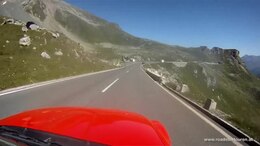
The Grossglockner High Alpine Road (colloquially also Glocknerstraße ; for other uses see Glocknerstraße ) connects the two Austrian federal states of Salzburg and Carinthia as a high alpine mountain road . It leads from Bruck an der Großglocknerstraße over the two mountain passes Fuscher Törl and Hochtor (tunnel portal 2504 m above sea level , historical pass height 2576 m above sea level ) to Heiligenblut am Großglockner and has branches to the Edelweißspitze and the Kaiser-Franz-Josefs- Height . It is the highest paved pass road in Austria.
The Großglockner High Alpine Road is primarily of touristic importance as an adventure road ; Driving is subject to a toll for motor vehicles .
course
The road from Bruck in the Salzachtal to Heiligenblut in the Mölltal is 47.8 km long and crosses the main Alpine ridge .
The road begins in Bruck, on the other side of the Salzach at the Lukashansl inn . It is designated as a state road for the first 10 kilometers (L271 Großglockner Landesstraße ), since the construction of the Bruck bypass of the B311 Pinzgauer Straße only from the junction with this. It is a public road up to km 10 ( Embachkapelle in Fusch).
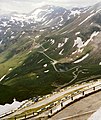
In the Fuscher valley, the road runs through the village of Fusch on Glocknerstrasse to the Ferleiten toll station ( 1151 m above sea level , ⊙ ). There it climbs over the Piffkar station ( 1633 m above sea level , ⊙ ) and past the Hexenküche block heap on the Obere Nassfeld ( Wilfried-Haslauer-Haus , 2268 m above sea level , ⊙ ) and on the Fuscher Törl ( 2428 m above sea level , ⊙ ) between the Fuschertal and the Raurisertal in many serpentines. At the Fuscher Törl, the approximately 2 km long Edelweißspitze panorama road ( 2571 m above sea level ) branches off.
Then the road drops to Fuscher Lacke ( 2261 m above sea level , ⊙ ) and tunnels through the Mittertörl ( 2375 m above sea level ; tunnel height 2335 m above sea level , ⊙ ), where the Seidlwinkel valley drops into the Rauris at Wegscheid . Another tunnel crosses the Salzburg-Carinthian border and the Salzach (Inn) / Drau watershed at the Hochtor ( 2576 m above sea level ; tunnel height 2506 m above sea level , ⊙ ) .
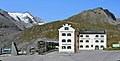
From the main road, the glacier road leads far into the Mölltal valley to the Kaiser-Franz-Josefs-Höhe ( 2369 m above sea level , ⊙ ) on the Pasterzen glacier with a view of Großglockner , while the Glockner road itself leads down to Heiligenblut. On the Carinthian side, the Wallackhaus and Schachnern are on the road. The Heiligenblut toll house ( 1691 m above sea level , ⊙ ) is still high above the village.

The Glockner Bridge at kilometer 0 in Bruck

Ferleiten toll station

View of the rear Käfertal

Käfertal from the Wilfried-Haslauer-Haus

Serpentines Oberes Naßfeld with Wilfried-Haslauer-Haus

The observation tower on the Edelweißspitze

First view of the Fuscherkarkopf from the Salzburg side, on the Fuschertörl
From Fuschertörl towards Mittertörl / Hochtor

Fuscher Lacke with Mankeiwirt and road keeper's house
Glocknerhaus with Franz-Josefs-Straße to Pasterze, behind the Großglockner

View from Schöneck on Gletscherstraße towards Glockner

Heiligenblut toll booth

South ramp, Heiligenblut and toll booth above


.JPG)


history
| Hochtor | |||
|---|---|---|---|
| Compass direction | North | south | |
| Pass height | 2504 m above sea level A. | ||
| state | Salzburg | Carinthia | |
| Watershed | Fuscher Ache ( Salzach ) | ( Möll ) | |
| Valley locations | Bruck | Heiligenblut | |
| expansion | Road (Grossglockner High Alpine Road, toll), top of the pass: tunnel | ||
| Built | 1930-1935 | ||
| Winter closure | Late October to early May | ||
| Mountains | Glockner group | ||
| particularities | Highest paved pass road in Austria; actual pass height 2576 m above sea level. A. | ||
| profile | |||
| Ø pitch | 5.7% (1894 m / 33 km) | 7.9% (1218 m / 15.5 km) | |
| Max. Incline | 12% | 12% | |
| map | |||
|
|||
| Coordinates | 47 ° 4 ′ 57 " N , 12 ° 50 ′ 32" E | ||

The way over the Hochtor is an old Roman road , a mule track that was already used in the Hallstatt period according to pre-Celtic finds. Since a bronze Hercules statuette was found during the construction of the High Alpine Road at 2,600 m above sea level in 1933, there has been scientific controversy over the authenticity of the location. Large-scale excavations were only carried out in the pass area from 1994 onwards, and an extensive pass sanctuary was gradually discovered. Fragments of around 20 other bronze statuettes, Roman copper coins, but above all Celtic silver coins from the 1st century BC. As well as fibulae and pieces of jewelry, several small divine shrines along the crest of the pass are documented. A softwood board apparently used for the construction of one of these shrines could be found in the 2nd century BC. Can be dated to 1st century AD.
In the 17th century, this crossing was the third most important alpine crossing in Austria after the Brenner Pass and the Radstädter Tauern Pass . The main route never ran primarily to the remote Fusch, but via the Seidlwinkeltal and - since the High Middle Ages - via the Rauriser Tauernhaus to the Rauris with its rich gold finds and from there to the Pongau Salzach Valley.
In the times of the Habsburgs , the Glockner area was still the emperor's hunting ground, and as a starting point there was an accommodation hut in the Gamsgrube on the south side since 1834 and the Glocknerhaus since 1875 , to which the ÖAV section Klagenfurt as owner built a driveway until 1908, which later became the Glocknerstrasse opened.
The section between Heiligenblut and the Glocknerhaus (today's southern ramp and Gletscherstraße) was ceremoniously opened on July 16, 1905 and called Kaiserin-Elisabeth-Straße .
In the 1920s the daily and specialist press discussed many more or less promising projects to open up the Alps for tourist traffic. These included, for example, the Vienna Höhenstrasse or the planned, but never built, Wienerwaldbahn into Tullnerfeld . According to the original plans in Carinthia and Salzburg in June 1924, a “Grossglockner High Alpine Road” between Heiligenblut and Ferleiten was to be built as a private toll road. The engineer Franz Wallack (1887–1966), who was in the Carinthian State Services, was commissioned in 1924 with the creation of a general project for the route and for several mountain hotels. The Wallackhaus , a hotel located directly on the High Alpine Road, was named after him. Wallack submitted a first draft within a few weeks.
The project “Grossglockner High Alpine Road” was of particular importance as South Tyrol was separated from Austria with the Peace Treaty of St. Germain and the former inner Austrian connection from Carinthia to North Tyrol over the Brenner Pass was lost. Since there was no road over the main Alpine chain on the 156 kilometers between the Radstädter Tauern Pass and the Brenner Pass, Upper Carinthia and East Tyrol were cut off from direct road traffic with the federal states on the northern edge of the Alps, so that in the summer of 1922 the then tourism office in the Federal Ministry for Commerce, Industry and Buildings proposed building a road. However, due to lack of money and dwindling expectations of success, activities ebbed by the end of the 1920s.
The ambitions for the construction finally shifted to Salzburg, where Governor Franz Rehrl campaigned for the implementation of the project. Rehrl was known as a passionate driver and made the realization of the road his personal goal. In 1928/1929 he linked the plans to build Glocknerstrasse with an oversized Tauern power plant project by AEG Berlin, which thereby acted as a shareholder in Grossglockner-Hochalpenstrasse Aktiengesellschaft (GROHAG), but left it again in 1931 after the power plant plans failed. Only a special law to finance the completion of the construction phases that began in 1930 could avert international disgrace. On August 30, 1930, the construction of the road was symbolically opened with an explosive shot in Ferleiten. At the end of 1932, the north ramp and the glacier road to Pasterze were ceremoniously opened to the public. The building cost the equivalent of 65 million euros, worth 510,000 euros less than originally estimated. However, the costs burdened the republic in a time of severe depression, so that in the end GROHAG had to be liquidated.
When the authoritarian Dollfuss government came to power in March 1933, a car-friendly turn in Austrian economic policy followed with a view to the success of the Nazi motorization policy in the neighboring country. The focus was on a large-scale road construction program to create jobs. In connection with the attempt - only to a limited extent - to reduce unemployment in this way, the Großglocknerstrasse project was revived only a few months after the liquidation of GROHAG. In the years 1930 to 1935, 14% of the total road construction expenditure was concentrated on Glocknerstrasse. In addition, automotive sports events were promoted, and tax breaks such as the abolition of the vehicle tax in 1935 contributed to a small car boom.

On September 22nd, 1934, Franz Rehrl was the first to cross the Hohe Tauern in a car on the substructure in a converted Steyr 100 . On August 3, 1935, the Grossglockner High Alpine Road was opened after a five-year construction period. The construction of the high mountain road had created a considerable amount of jobs, but this effect was limited in comparison to the German armaments economy. A total of 3200 employees were significantly involved in the construction. One day after the opening, the Grand Mountain Prize of Austria for automobiles and motorcycles took place.
In the course of job creation measures , the southern access road between Heiligenblut and Dölsach was also expanded into a modern road from 1937 .
Recent history
Automobile manufacturers have been carrying out brake tests here since around the dawn of the road . These can be recognized by the quickly repeating up and down journeys with a vehicle without going through the toll booth, sometimes by measuring recording devices in the car, by a measuring wheel that is dragged along and by the smell of highly heated brake pads. For many years there have been tickets for test drives for 1 and 4 days.
In 2011, an automobile exhibition was opened in the visitor center on Kaiser-Franz-Josefs-Höhe.
In 2013, a driver drove his car downhill due to overheated brakes on a left-hand turn-out, collided with an oncoming motorcyclist who died in the process.
Safety training trips for motorcyclists have been taking place here since 2014, organized by the police (Salzburg regional traffic department) and the road operator GROHAG.
In the interests of traffic restrictions and the safety of our own employees, in the year of the corona pandemic 2020, the road was cleared of snow much later and no motorcycle safety training was held until August.
On July 1, 2020 the exhibition "Trabi rush on the Großglockner - pure freedom of travel on the occasion of 30 years of the fall of the Berlin Wall " was opened.
Seven artists, including Anna Meyer, Iris Andraschek, Huber Lobnig and Ralo Mayer, created large paintings and installations dealing with the location in several weeks as part of the “Serpentine” art project. The presentation on August 24, 2020, for example at rest areas along the road, is scheduled for 3 years.
Today's meaning
business
The Großglockner High Alpine Road is a private road with public rights. It is impassable in winter between Ferleiten and Heiligenblut; Snow depths of more than ten meters are not uncommon, the record is 21 meters in 1953. Depending on the weather conditions, the winter closure runs from around the end of October to the beginning of May. There is also a night closure. The two toll booths are manned between 5:00 a.m. and 9:30 p.m. in the high season, 6:00 a.m. to 8:00 p.m. in the spring and 6:00 a.m. to 7:30 p.m. in the autumn in the low season.
In the course of the snow removal, which takes place uphill from the north and south, threatening avalanches must also be blown up. A total of 4 or 5 “System Wallack” rotary milling machines, built in 1953, named by the first names of the mechanical engineers who helped develop them, “Paul”, “Ander”, “Oskar”, “Jörgen” - and the “Eisbändiger” are in use to this day. The breakthrough took place on April 26th in 2016; Due to snowfall on April 27 and 28, the ban was extended to May 2 due to the danger of avalanches.
When the snow clearing began on April 10, 2017, there was as little snow as there had been for 20 years. Afterwards in the Easter weekend the following snowfalls, cold and winds up to 5 m high led to the danger of avalanches and repeated withdrawal of the clearing teams. The breakthrough took place on May 2, 2017, and in places the walls of snow on the road were 6 m high.
Because of the COVID-19 pandemic , Großglocknerstrasse will not be cleared for the first time in its history in April 2020. However, wind breakage is eliminated. GROHAG director Hörl does not expect a necessary decision before May 20th. If travel and exit restrictions remain in place, the 75% share of visitors who come from abroad will be lost and it is foreseeable that the 2020 season will not be profitable.
Transport and tourism

While the Großglockner High Alpine Road is of secondary importance as a transit route , it is primarily a tourist attraction as one of Austria's great adventure roads. In addition to crossing the main Alpine ridge as a delightful travel route, it offers access to Austria's highest mountain and landmark, the Grossglockner, in particular with the glacier road to Kaiser-Franz-Josefs-Höhe. Due to the historical development, it represents a special case of the traffic-technical development of one of the most important - and away from the traffic route strictly monitored - nature reserves of the central Alps , the Hohe Tauern National Park . It is a model case for how the divergent needs of tourists and the Austrian public interest, the neighboring communities, the operator, the alpine clubs and nature conservation can be combined on an economic and ecological basis in a modern concept of sustainable tourism.
The volume of traffic is around 270,000 vehicles per year (cars, buses, motorcycles - 2007), which corresponds to around a million visitors. In total, around 50 million people have used the street in the history of the street. In addition, European automobile manufacturers like to use the road to test the climbing ability and braking performance of vehicles under realistic and extreme conditions.
Until 2012 there was a daily Postbus route that ran from Lienz via the Großglockner to Zell am See in the summer months. The legendary "Glocknerbus" was used on it for decades. This line was discontinued after 77 years due to a lack of agreement on how to cover the deficit. Currently, there is only one post bus route from Heiligenblut to Franz Josefs-Höhe, and a private excursion bus runs from Hinterglemm / Zell am See to Franz Josefs-Höhe and back two days a week if you reserve in advance.
125 years of automobilism
With the exhibition on the Kaiser-Franz-Josefs-Höhe in 2011, a permanent exhibition as a museum about 125 years of automobilism was set up by the operating company. This museum with an exhibition area of around 1,000 m² is considered the highest automobile museum in the world.
heritage Site
The road is considered an important technical monument that is outstanding for the history of Alpine traffic and is being carefully renovated in relation to the original facility despite all the necessary road construction measures. Since 12./25. In January 2016 it is also on the list of proposals for UNESCO World Heritage ( tentative list , list entry ). The aim was to register it by summer 2018 in 2016. [obsolete] Since the Hohe Tauern National Park has also been on the list since 2003, there is also a joint recording as a natural and cultural landscape.
The proposal for inclusion as a combined world natural and cultural heritage was withdrawn in order to forestall a negative decision. The rejection was to be expected because the Salzburg and Tyrolean sections were too anthropogenic . As of April 2020, Christian Schuhböck, Secretary General of Alliance for Nature, advocates the nomination of the Hohe Tauern National Park as a World Heritage Site.
Cycling
The Großglockner High Alpine Road has also been of great importance for cycling races since it was founded.
Giro d'Italia
Already at the Giro 1971 there was a mountain arrival on the Kaiser-Franz-Josefs-Höhe, which the Italian Pierfranco Vianelli won. It was the 17th stage that led from Tarvisio (Friuli) over 206 kilometers to the Grossglockner. In 2011 the Giro entourage returned to the Grossglockner High Alpine Road after 40 years. The 13th stage of the Giro d'Italia had its stage destination on Friday, May 20, 2011 on the Grossglockner High Alpine Road at the Glocknerhaus car park , about three kilometers from Kaiser-Franz-Josefs-Höhe.
Tour of Austria
The winner of the mountain classification on the Grossglockner High Alpine Road during the Tour of Austria is called the Glockner King . Until the early 1990s, Großglockner Strasse was almost exclusively included in the route. Since the beginning of the open era in cycling (amateurs and professional cyclists compete together) in 1996, the Glockner stage has been skipped several times. In 2000 there were two Glockner mountain stages, one from the south and one from the north. The variant that is driven more often is the one from the northern side with the Fuscher Törl as the highest category mountain rating. Christian Pfannberger set the fastest time on this section in 2007 with 47:20 minutes.
Race Around Austria

The Race Around Austria ultra bike race , which takes place annually in August, runs clockwise along the roads near the border around Austria. Due to its geographical location, the Grossglockner is an annual highlight in the program, with the Hochtor being the highest point of the race. The 2,200-kilometer non-stop bike race can be contested both as a single rider and in a team (two or four athletes share the route individually). At the Race Around Austria, the Glockner is driven from the southern side. Since the race is already around 1,200 kilometers long at the time of the crossing, larger distances are not uncommon. The teams tackle the Glockner after the second night, the top individual drivers at the end of the second day or the beginning of the third night of the race. It takes around two days for all athletes to conquer the Glockner.
Peak break

Since 2008, up to 18 Alpine passes have been conquered every year as part of the Peakbreak cycling stage race . The competition is held for individual riders and teams and is one of the toughest stage races in the world for ambitious amateur racing cyclists. The race consists of seven to eight daily stages that lead through Tyrol, Salzburg, Styria and Carinthia within Austria. Every year the Großglockner High Alpine Road is one of the highlights of the route. In contrast to many other bike races, the Grossglockner stage begins at the peak break in East Tyrol and thus leads via Heiligenblut in Carinthia, first over the south side of the Alpine pass. The winners of the Großglockner stages are:
- 2008: Christoph Strasser (time: 04: 34: 31.7 - stage route Lienz - Kitzbühel )
- 2010: Reinhard Woisetschläger (time: 05: 29: 52.5 - stage route Lienz– Going am Wilden Kaiser )
- 2011: Reinhard Woisetschläger (time: 05: 08: 51.2 - stage route Lienz – Going am Wilden Kaiser)
- 2012: Ewald Robeischl (time: 04: 31: 40.5 - stage route Lienz– Neukirchen am Großvenediger )
Glocknerman
The long-distance race Glocknerman , from (and to) Graz -Webling (1997–1998, however: Unterpremstätten ) has been held since 1997, which , depending on the level of difficulty, leads up to, over or even twice over Glocknerstrasse.
Hobby sport
Many amateur athletes and touring cyclists also set themselves the goal of tackling the Großglockner by bike. With the end of the winter closure 2010/2011, a cyclist's toll of € 5 should be collected between 9 a.m. and 3 p.m. The planned step was justified with the intended shift of the number of cyclists to the end of the day and the allegedly increased safety risk associated with the steadily increasing number of cyclists. However, the cyclist's toll was not introduced due to the negative reactions to the imbalance of the proposal. In 1935, after the opening of the Alpine toll road, it cost one shilling to use for cyclists .
Conservation and research
The Glocknerstraße divides the Hohe Tauern National Park into two separate areas, both in terms of legal designation and as a certain barrier for animal migration, which is limited by the nightly closure (and the winter closure). On the Salzburg side, the area along the road is designated as the Grossglockner High Alpine Road landscape protection area ( LSG00057 ), which in a way closes the gap in the protected area. The area comprises strips of 200 m each on both sides of the route in the municipality of Fusch, covering an area of 717 hectares . The purpose of the protection is to “preserve 1. the special natural beauty of the area with impressive views of the partly glaciated high mountain scenery of the Hohe Tauern; 2. the particularly high adventure and recreational value of the characteristic, largely original natural landscape and the near-natural alpine farming landscape. ”The protected area was designated as early as 1957.
The high-alpine research station of the Haus der Natur Salzburg has been set up in the Wilfried-Haslauer-Haus on Upper Nassfeld, as well as a geological-ecological Alpine nature show .
piece of music
For the opening of the road was the composer and military bandmaster Kummerer Rudolf the Grossglockner march composed.
literature
Contemporary construction:
- Franz Wallack: The Grossglockner High Alpine Road. The history of their construction. 1949. (Wallack's autobiography and account of his project.)
Overcoming the forces of nature during the construction of the Großglocknerstrasse were devoted to novels that reflect the respective historical view:
- RR Wagner: Goldtauern. 1935.
- M. Limmer: The new way. 1940.
- Th. Kröger: Chiseled by the will. 1951.
Newer literature:
- Clemens M. Hutter, Lothar Beckel: Grossglockner. Mule track, Römerweg, High Alpine Road. 2nd edition, Residenz Verlag, Salzburg 1988, ISBN 978-3-7017-0395-1 .
- Clemens M. Hutter: Grossglockner High Alpine Road. 2nd edition 2007, ISBN 3-9500227-6-7 .
- Georg Rigele: The automization in the new Austria; Shown using the example of the Grossglockner High Alpine Road 1928–1938. In: Technology - Politics - Identity. Edited by Klaus Plitzner. GNT-Verlag, Stuttgart 1995, ISBN 978-3-928186-27-8 , pp. 137-147.
- Steffan Bruns: Alpine passes - from the mule track to the base tunnel. Vol. 4. ISBN 978-3-88675-274-4 , pp. O. A.
- Ortolf Harl: Hochtor and Glockner route. A high alpine pass sanctuary and 2000 years of cultural transfer between the Mediterranean and Central Europe ( special publications of the Austrian Archaeological Institute, 50). Vienna 2014, ISBN 978-3-900305-68-0 .
Web links
- Website of the Großglockner High Alpine Road , Großglockner High Alpine Roads AG
- Entry on Grossglockner High Alpine Road in the Austria Forum (in the AEIOU Austria Lexicon )
- Großglockner High Alpine Road / Großglockner High Alpine Road. Entry in the tentative list of UNESCO (in English).
- Grossglockner High Alpine Road . In: Salzburger Nachrichten : Salzburgwiki .
- Grossglockner Hochalpenstrasse about its history and events grossglocknerpanoramastrasse.wordpress.com, blog from 2015 by Peter Krackowizer - history from the beginning, with pictures from the archive of his father Helmut Krackowizer
- Description of the route for racing cyclists , quaeldich.de
More special:
- Edith Danzer (GROHAG): Nobody like Jörgen, Paul and Oskar - the ice tamers on the Grossglockner High Alpine Road salzburgerland.com, 2012 - uses Wallack cutters to clear snow
- Entry on Grossglockner High Alpine Road in the Austria Forum (as a stamp image)
Individual evidence
- ↑ Grossglockner High Alpine Road
- ↑ As evidenced by the name of the municipality Bruck an der Glocknerstraße
- ↑ The operator uses the expression itself: Großglockner High Alpine Road: excursion destination in Austria. In: grossglockner.at. Retrieved May 30, 2017 .
- ↑ Glocknerstrasse open again - salzburg.ORF.at. In: salzburg.orf.at. Retrieved May 30, 2017 .
-
↑ route description, grossglockner.at;
Alpine Club Card 40 Glockner Group , 1: 25,000 - ↑ Street profile, Grohag
- ^ Susanne Sievers , Otto Helmut Urban , Peter C. Ramsl: Lexicon for Celtic Archeology. A – K and L – Z. Announcements of the prehistoric commission in the publishing house of the Austrian Academy of Sciences , Vienna 2012, ISBN 978-3-7001-6765-5 , p. 698 f.
- ↑ Lit .: Hutter, Beckel, 1988
- ↑ Festschrift to celebrate the 50th anniversary of the Glocknerhaus of the Klagenfurt Section of the D. Ö. AV (PDF) Retrieved August 15, 2017 .
-
^ Austrian tourist newspaper. No. 15/1905, p. 190.
Festschrift Heiligenblut - Das Glocknerdorf. Chapter 21: From the Saumweg to Glocknerstrasse ; Lit. Hutter, Beckel: Großglockner Saumpfad Römerweg Hochalpenstraße. S. o.A. - ↑ cf. Clemens M. Hutter: Großglockner High Alpine Road, 2007.
- ^ The Reichspost of May 16, 1937, p. 7.
- ↑ Information by telephone, Ferleiten, August 24, 2020.
- ↑ Overheated brake claims dead on Glocknerstrasse heute.at, August 12, 2013, accessed August 24, 2020.
- ↑ Organizational chart for the State Police Department Salzburg polizei.gv.at, accessed on August 24, 2020.
- ↑ Großglockner High Alpine Road Motorcycle Driving Safety Training sn.at, Salzburg Wiki, accessed August 24, 2020.
- ↑ (OTS) Motorcycle safety training at the Großglockner regionews.at, July 21, 2018, accessed August 24, 2020.
- ^ Trabi exhibition: Großglockner - A symbol of freedom mein district.at, July 1, 2020, accessed August 24, 2020.
- ↑ Artworks at Großglocknerstraße orf.at, August 24, 2020, accessed August 24, 2020.
- ↑ Snow clearance , Grohag - with images of the legendary " Wallack tiller " in action
- ↑ News , Grohag
- ↑ Snow: Glocknerstraße closed until May 3 , orf.at, April 29, 2016, last accessed May 4, 2016.
- ↑ breakthrough at Glocknerstraße clearing orf.at, May 2, 2017, accessed May 2, 2017.
- ↑ Großglocknerstrasse will not be cleared. orf.at, April 17, 2020, accessed April 17, 2020. - With image of the milling machines “Ander” and “Oskar”.
- ^ The Grossglockner High Alpine Road today ( Memento from January 7, 2008 in the Internet Archive ), Grohag
- ↑ Glockner bus. In: Salzburg Wiki. Retrieved January 25, 2020 .
- ↑ Glockner remains on the left. In: Wiener Zeitung . August 2, 2012, accessed January 25, 2020 .
- ↑ Bus timetable on the website of the municipality of Heiligenblut. Retrieved January 25, 2020 .
- ↑ The Großglockner bus - an alternative. Retrieved January 25, 2020 .
- ↑ 125 years of automobilism in the Salzburg Wiki, accessed on April 19, 2013
- ↑ Großglockner High Alpine Road is a candidate for Unesco World Heritage . In: Der Standard online, January 25, 2016.
- ↑ World Natural Heritage Hohe Tauern and Donau-March-Thaya-Auen ?! alliancefornature.at, undated (accessed January 26, 2016).
- ↑ First notification LGBl. 62/1957 of October 1, 1957; Landscape protection area 00057 Großglockner High Alpine Road , Salzburg nature reserve.
- ^ The National Park Institute ( Memento of February 16, 2008 in the Internet Archive ), www.hausdernatur.at
- ↑ “Großglockner March” 1 by Rudolf Kummerer ( memento of the original from January 19, 2016 in the Internet Archive ) Info: The archive link has been inserted automatically and has not yet been checked. Please check the original and archive link according to the instructions and then remove this notice. including notes, page 12 (PDF) from November 2011, accessed January 19, 2016.
Ahorn • Alpl • Ammer • Annaberg • Arlberg • Ascher • Bieler • Birkfelder • Boding • Brenner • Buchauer • Buchener • Dientner • Dürrholzer • Eibegg • Erb • Eisental • Faschina • Feistritz • Fern • Filzen • Flattnitz • Flexen • Forsthof • Furka • Fuscher • Gaberl • Gaden wide • Gailberg • Gangleit • Geiseben • Gerichtsberg • Gerlos • Geschriebenstein • Goller • Grießen • Griffner • Large Kripp • Grubberg • Grünbacher • Gschuett • Hafner • Hahntenn • neck • Haselrast • Hebalm • stallion • Hengstl • Hiaslegg • Hirschegger • Hochegger • Hochrindl • Hochtannberg • Hochtor • Holzleiten • Iselsberg • Josefsberg • Kaiserauer • Cold Kuchl • Kartitscher • Katsch • Kernhofer • Kerschbaumer • Klachauer • Klamm • Klamml • Small Kripp • Klippitz • Klostertaler • Kraxen • Kreuth • Kreuzberg • Kühtai • Lahn • Lienbach • Loibl • Losen • Luft • Mendling • Michelbühel • Moarigraben • Nassfeld • Neumarkter • Niederalpl • Norberts • Nöring • Obdacher • Oberjoch • Och • Pack • Paulitsch • Perchauer • Pfaffen • Pfarralm • Pielachtaler • Piller • Plöcken • Pogusch • Pölshals • Pötschen • Präbichl • Prebersattel • Preiner • Pretal • Promau • Pyhrn • Radl • Radling • Radstädter • Radstatt • Rams • Raneck • Rechberg • Rieder • Rohrer • Sattler • Saurüssel • Schaida • Schanz • Scharflinger • Schiestel • Schober • Schönfeld • Schwarze Sau • Schwarzenbichl • Seeberg • Seefelder • Semmering • Kleiner Semmering • Sieggraben • Silzer • Soboth • Summer • Staller • Styrian Seeberg • Straßegg • Sölk • Thurn • Timmels • Triebener Tauern • Turracher • Origin • Wechsel • Weinebene • Weißenbacher • Wagrainer • Windische • Wurzen • Zellerrain