Fog (amrum)
| coat of arms | Germany map | |
|---|---|---|

|
Coordinates: 54 ° 39 ' N , 8 ° 21' E |
|
| Basic data | ||
| State : | Schleswig-Holstein | |
| Circle : | North Friesland | |
| Office : | Foehr-Amrum | |
| Height : | 6 m above sea level NHN | |
| Area : | 11.96 km 2 | |
| Residents: | 905 (Dec. 31, 2019) | |
| Population density : | 76 inhabitants per km 2 | |
| Postal code : | 25946 | |
| Area code : | 04682 | |
| License plate : | NF | |
| Community key : | 01 0 54 085 | |
| Office administration address: | Hafenstrasse 23 25938 Wyk auf Föhr |
|
| Website : | ||
| Mayor : | Cornelius Bendixen ( CDU ) | |
| Location of the municipality Nebel in the district of North Friesland | ||
Nebel ( North Frisian Neebel , Danish Nebel ) is one of the three communities on the North Frisian North Sea island of Amrum , along with Wittdün on Amrum and Norddorf on Amrum . The municipality belongs to the district of North Friesland in the state of Schleswig-Holstein . The districts of Süddorf and Steenodde belong to the municipality of Nebel .
Geography and traffic

The historic center of Nebel is located on the eastern side of Amrum's Geestrücken , facing the Wadden Sea , in the longitudinal direction approximately in the center of the island. Almost two kilometers south of this are Süddorf and Steenodde, and south of Süddorf is the Großdün residential area . The western part of the village of Nebel is called Westerheide .
The districts of Nebel and Süddorf are connected to the other two island communities by Amrum's main street, Landesstraße 215. The municipality of Nebel is connected with four stops to the only bus line on the island that runs on the main road. However, Steenodde has no bus connection. Until 1939 there was a terminal station of the Amrum island railway in Nebel . A port with a pier and a few berths for smaller ships is located in Steenodde.
Until the end of 2006, Nebel was the administrative seat of the Amrum Office and was thus the administrative capital of the island. There is the on Nebeler municipality Lighthouse Amrum that Amrumer windmill and St. Clement's Church , as landmarks are on the island.
history
Nebel was founded in the first decades of the 16th century as the third island village after Norddorf and Süddorf. The place name is probably derived from the words nei and bel , the former meaning “new” and the latter based on the old Danish term boli (settlement) (compare Niebüll , Nieblum ). The first houses of this new settlement were grouped around the St. Clemens Church, which had previously stood in the open for two centuries between the north and south villages.
After the annexation of Schleswig-Holstein by Prussia in 1867, there was only one community called Amrum , which encompassed the entire island from June 27, 1871 . In 1912 the municipality of Wittdün was formed from the southern part of the island, and in 1925 the municipality of Norddorf was formed from the northern part. The remainder of the community renamed itself to Nebel on February 23, 1926.
While numerous hotels were built in Wittdün and Norddorf from 1890, there was little tourism in Nebel at first. In 1890 the Kurhaus Satteldüne was built between Nebel and Süddorf, which has functioned as a children's health center and children's clinic since 1923. In 1905 a sanatorium was built near the church, the current spa administration. It was not until 1938 that the community received a concession to use the beach.
After the Second World War, large areas of the heather west of Nebel became cheap building land. The Westerheide residential area was created there.
Districts
Steenodde
Steenodde is the smallest Amrum village. It is right on the Wadden Sea. The barrows and barrows , which are very numerous here, are worth seeing ; The Steenodder Dolmen is also one of the sights. Steenodde has its own navigable pier. Steenodde used to be the ferry port for the Amrum - Halligen - Schlüttsiel (mainland) ferry line . Today there is a port for small cargo ships and sport boats up to 12 meters in length. The oldest surviving Amrum house, the former Lustiger Seehund inn , is located in Steenodde. It was built in 1721.
South village
Süddorf was first mentioned in a document in 1464 and is therefore, together with Norddorf, the oldest island village. The seafarer Hark Olufs , who was born and died in Süddorf, achieved fame in the 18th century .
Amrum's second, smaller windmill is located in Süddorf and is now used as a residential building. It was originally built in 1775. In 1882 the Amrum captain Volkert Quedens bought the mill and had it rebuilt in Süddorf for the miller Heinrich Andresen. In 1893 it was converted into a Dutch windmill with sail gate blades and was in operation until 1939.
The best-preserved piece of the Krümwals , a 1,800-meter-long earth wall, stretches from Süddorf to the east . Its purpose and when it was created are unknown.
The Amrum School, founded in 1968, is located on the north-eastern edge of the district. It is called Öömrang skuul ( öömrang ; German: "Amrumer Schule") and is a primary and regional school with a support center .
South of Süddorf, still in the area of the municipality of Nebel, is the Amrumer lighthouse , which was put into operation on January 1, 1875 and has the second highest fire height of all beacons on the German North Sea coast after the Helgoland lighthouse . He stands on a 27 m high dune . The fire height is 63 m above sea level. NN . Due to its size and the characteristic red and white paint, the lighthouse is the most distinctive building on the island of Amrum.
politics
Since the local elections in 2018 who Wählergemeinschaft Nebeler Bürgerblock (NBB) five seats, the CDU four and the SPD two seats in the municipal council.
Sights in the town of Nebel
St. Clement's Church
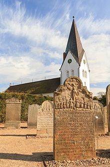
The St. Clemens Church , built in 1236 and first mentioned in a document in 1240, stands on the eastern edge of the town center . The Romanesque , single-nave building with thatched roof was built at the time due to disagreement about the location between the island villages of Norddorf and Süddorf and gave rise to the later establishment of Nebel. The church was built without a tower; the 36 meter high, copper-roofed church tower was only added in 1908.
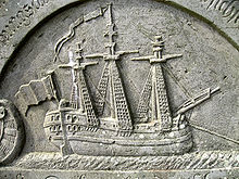
The church houses a number of art treasures. This includes a wooden, early Gothic group of apostles ( The Heavenly Supper ), which is said to have washed ashore in a storm surge on Amrum. The figures are characterized by strict frontality, relatively large heads and simple folds. The expressive faces reflect intimacy and deep seriousness. The chalice-shaped baptismal font comes from the Romanesque period. He is estimated to be about the same age as the Church. Its dome and walls are made of reddish glittering granite, the bulge ring and base are made of yellowish shell limestone . It stands in the northeast corner of the nave, surrounded by benches in such a way that a separate baptismal font was created. The narrow nave, crossed by a wooden gallery on the long side and above the entrance at a low height , gives the spatial impression of a ship's hull. Also worth seeing is the cemetery in front of the church with gravestones from the period from 1670 to 1830. In addition to depictions of ships and elaborate ornamentation, these show short texts carved in stone about the life of the deceased.
The St. Clement's church community is in possession of a copy of the Missal Slesvicense , one in 1486 by Steffen Arndes printed Missal , which is preserved in only four copies and the oldest in Schleswig-Holstein and the second oldest in Denmark applies a printed book. The book is in the Landeskirchliche Archiv in Kiel and is occasionally exhibited in the church.
Windmill
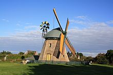
The Amrumer Windmill was built in Nebel in 1771 by the miller Erk Knudten, and today it houses a local museum and exhibitions by various artists in the summer. The mill is a dutchman with barley barrel , louvre flap wings and compass rose, which was in operation until 1962. The pastor at the time, Erich Pörksen, initiated the foundation of the Association for the Preservation of the Amrum Windmill in 1964 . The mill is still operational today and can be visited.
An Amrum-specific Christian ritual is associated with the Nebeler windmill: the four wings of the mill are usually aligned diagonally “in the scissors” when they are not in use. In the event of a death on the island, the mill wings are brought into a horizontal-vertical position up to the hour after the burial of the deceased in order to point out the death from afar - the mill is then "in the cross".
Homeless cemetery
Opposite the windmill is the Amrum cemetery of the homeless , where unidentifiable water corpses were buried. According to the church chronicle, this was laid out in 1905. A captain from Amrum voluntarily ceded the cemetery area from his land. Most of the graves date from the beginning of the 20th century, the last from 1969. Since then, all drowned people found in front of Amrum have been identified thanks to better techniques. Each grave is marked with a simple wooden cross with the date of discovery carved into it. The wooden archway of the entrance portal to the cemetery bears the inscription "There is still some rest". Immediately behind the entrance is a field stone from the old western wall of St. Clement's Church with the engraved words "Rejoice that your names are written in heaven".
Öömrang Hüs
The Öömrang Hüs in Nebel, Waaswai 1, is a Uthland Frisian house that was largely left in its original state and was built around 1751 and belongs to Öömrang Ferian . The original owner was a captain who had his ship depicted on a tiled wall in the living room ("de Dörnsk "). The house can be visited. The living culture of bygone days is shown in the kitchen, living room and other rooms. Changing exhibitions take place in an extension, and civil weddings are held in the living room of Öömrang Hüs.
More Attractions
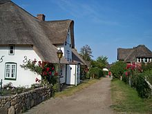
The center of Nebel is characterized by numerous thatched houses from the 18th and 19th centuries as well as unpaved village streets. The barrow of fog is located approximately 500 meters northwest of the duck decoy Meeram or Meerum. The 2014 replica of an Iron Age house is located in a prehistoric settlement area nearby . The Nebel lighthouse, built in 1981, is a modern, 9.6 m high construction made of aluminum. Due to its location, the beacon for the north floodplain has a fire height of 16 m above MThw (mean high tide) and a range of 15.6 to 19.5 nm.
economy
The “Satteldüne” specialist clinic for children and young people is Amrum's largest employer. It is located in the south of Westerheide, specializes in respiratory diseases and has its own school.
The most important economic factor is tourism. In 2012, 41,561 overnight guests were counted in the municipality of Nebel with 447,808 overnight stays. This number does not include patients and accompanying persons at the “Satteldüne” clinic.
Personalities
Sons and daughters of the church
- Hark Olufs (1708–1754), navigator from Süddorf
- Lorenz Friedrich Mechlenburg (1799–1875), pastor, poet and linguist
- Carsten Pörksen (* 1944), politician (SPD), MdL Rhineland-Palatinate
Other personalities
- Elfriede Rückert (1918–2016), the German-Austrian actress lived in Nebel the last few years before her death
- Magnus Weidemann (1880–1967) was pastor in Nebel from 1908 to 1909. He designed the steeple of St. Clemens Church.
Others
Nebel is the municipality with the highest proportion of second homes in Schleswig-Holstein. In 1991 the proportion was almost 50 percent.
literature
- Georg Quedens : Amrum. 24th revised edition. Breklumer Verlag, Breklum 2010, ISBN 978-3-7793-1110-2 .
- Georg Quedens, Hans Hingst, Gerhard Stück, Ommo Wilts: Amrum - landscape, history, nature. Jens Quedens Verlag, Amrum 1991, ISBN 3-924422-24-9 .
- Erich Pörksen: The landmarks of the island of Amrum. 2nd Edition. Breklumer Verlag, Breklum 2002, ISBN 3-7793-1119-4 .
Web links
Individual evidence
- ↑ North Statistics Office - Population of the municipalities in Schleswig-Holstein 4th quarter 2019 (XLSX file) (update based on the 2011 census) ( help on this ).
- ↑ a b Quedens: Amrum. P. 54 ff .: The island villages - Nebel
- ↑ State Statistical Office Schleswig-Holstein (Ed.): The population of the communities in Schleswig-Holstein 1867-1970 . State Statistical Office Schleswig-Holstein, Kiel 1972, DNB 740670093 , p. 237 .
- ↑ State Statistical Office Schleswig-Holstein (Ed.): The population of the communities in Schleswig-Holstein 1867-1970 . State Statistical Office Schleswig-Holstein, Kiel 1972, DNB 740670093 , p. 96 f. and 104 f .
- ↑ a b George Quedens , Hans Hingst, Gerhard piece Ommo Wilts: Amrum - landscape, history, nature. Jens Quedens, Amrum 1991, ISBN 3-924422-24-9 , p. 205.
- ^ Website of the Föhr-Amrum office , accessed on May 30, 2010.
- ^ Pörksen: The landmarks of the island of Amrum. P. 69 f .: The mill in Süddorf
- ↑ Local elections on Amrum: surprise in fog. amrum-news.de of May 11, 2018, accessed on September 16, 2018
- ↑ Quedens / Hingst / Stück / Wilts: Amrum. P. 81 ff .: The St. Clemens Church
- ↑ a b c Pörksen: The landmarks of the island of Amrum. Pp. 17-39.
- ↑ Quedens: Amrum. P. 46 ff .: Church and cemetery
- ↑ Quedens / Hingst / Stück / Wilts: Amrum. P. 158: Mills on Amrum
- ^ Dune school on the clinic's website ( Memento from March 4, 2016 in the Internet Archive )
- ↑ Georg Quedens : Amrum 2012. Quedens, Amrum 2013, ISBN 978-3-943307-10-8 , p. 49.


