Jabloňov
| Jabloňov | ||||
|---|---|---|---|---|
|
||||
| Basic data | ||||
| State : |
|
|||
| Region : | Kraj Vysočina | |||
| District : | Žďár nad Sázavou | |||
| Area : | 885 ha | |||
| Geographic location : | 49 ° 19 ' N , 16 ° 5' E | |||
| Height: | 496 m nm | |||
| Residents : | 346 (Jan. 1, 2019) | |||
| Postal code : | 594 01 | |||
| License plate : | J | |||
| traffic | ||||
| Street: | Velké Meziříčí - Velká Bíteš | |||
| structure | ||||
| Status: | local community | |||
| Districts: | 1 | |||
| administration | ||||
| Mayor : | Pavel Švec (as of 2018) | |||
| Address: | Jabloňov 52 594 01 Velké Meziříčí |
|||
| Municipality number: | 595730 | |||
| Website : | www.jablonov.cz | |||
Jabloňov (German Jablonau , 1939–45 Gablans ) is a municipality in the Czech Republic . It is located six kilometers southeast of Velké Meziříčí and belongs to the Okres Žďár nad Sázavou .
geography
Jabloňov is located on the right side above the valley of the Polomina brook in the Křižanovská vrchovina ( Krischanauer Uplands ) belonging to the Bohemian-Moravian Highlands . To the north rise the Hora (610 m) and Strážnice (610 m), to the west the Malý Strážník (492 m) and the Holomina (507 m). The D1 motorway passes in the south , the next exit is at Lhotka.
Neighboring towns are Březejc in the north, Ronov , Ořechov and Tři Dvory in the northeast, Ruda in the east, Lhotka in the southeast, Dvořáci and Tasov in the south, Dolní Heřmanice in the southwest, Petráveč in the west and Domky, Děkanův Dvůr and Dolní Radslavice in the north-west.
history
The village was first mentioned in 1361 as the possession of Radslavice radon. In 1366 Jan von Meziříčí acquired parts of Jablonov and joined them to his rule Tasov ; the other share held Václav and Ratibor von Myslibořice. In 1398 Kuneš von Tasov owned the entire village. Jabloniev was attached to the Meziříčí rule before 1515 and remained with her until 1848. The village was the seat of a judge, who also had Eisenberg , Křeptov, Březejc and Nebštych . At the end of the 16th century the judges' seat was moved to Eisenberg. To the northwest of Jablonau was the Klenuwky manor. There was still a drying hut, blacksmith shop and two flat kilns in the village. A place seal with an apple has been proven since 1641. In 1818 a school was built in the village, which in 1831 moved into its own schoolhouse.
After the abolition of patrimonial formed Jablonau 1850 a district of the municipality Eisenberg in the Bezirkshauptmannschaft United Meziříčí . In 1875 the political municipality Jabloňov / Jablonau was established. In the same year 18 houses burned down. A volunteer fire brigade was only established in 1901. During the time of the Protectorate of Bohemia and Moravia , the place was named Gablans . After the cancellation of the Okres Velké Meziříčí, the municipality came to the Okres Žďár nad Sázavou at the beginning of 1961 . 1980 Jabloňov was incorporated into Velké Meziříčí. The community has existed again since 1992.
Local division
No districts are shown for the municipality of Jabloňov. The location Klenůvka ( Klenuwky ) belongs to Jabloňov .
Attractions
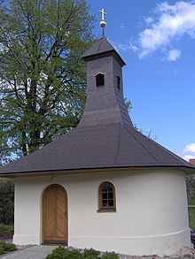
- Chapel and marble cross from 1901 on the village square
- Road bridge on road III / 602. The 16 m long structure leads over the Polomina in two 5 m long arches 2.5 m high.
- Prayer column, at the sports field
Sons and daughters of the church
- Bedřich Krejčí (1911–1945), literary scholar and poet, he died on a death march to Dachau concentration camp .


