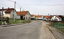
Otín u Měřína
| Otín | ||||
|---|---|---|---|---|
|
||||
| Basic data | ||||
| State : |
|
|||
| Region : | Kraj Vysočina | |||
| District : | Žďár nad Sázavou | |||
| Area : | 555 ha | |||
| Geographic location : | 49 ° 22 ' N , 15 ° 54' E | |||
| Height: | 514 m nm | |||
| Residents : | 329 (Jan 1, 2019) | |||
| Postal code : | 594 01 | |||
| License plate : | J | |||
| traffic | ||||
| Street: | Měřín - Čechtín | |||
| structure | ||||
| Status: | local community | |||
| Districts: | 3 | |||
| administration | ||||
| Mayor : | Jiří Mrázek (as of 2018) | |||
| Address: | Otín 37 594 01 Velké Meziříčí |
|||
| Municipality number: | 596370 | |||
| Website : | www.otin.cz | |||
Otín (German Wottin ) is a municipality in the Czech Republic . It is located eight kilometers west of Velké Meziříčí and belongs to the Okres Žďár nad Sázavou .
geography
Otín is located on the right side above the valley of the stream Žďárka in the Krischanauer Uplands ( Křižanovská vrchovina ) in the south of the Bohemian-Moravian Highlands . In the east lies the valley of the Balinka . The Pavlínovská horka (614 m) rises to the southwest and the Chlumek (628 m) to the west.
Neighboring towns are Pustina in the north, Nová Zhoř and Stránecká Zhoř in the north-east, Frankův Zhořec in the east, Šeborov and Uhřínov in the south-west, Pohořílky in the south, Pavlínov in the south-west, Geršov in the west and Měřín in the north-west.
history
Votín was first mentioned in a document in 1379. At that time, part of the village belonged to the Meziříčí rule . The local Freihof and the Stránecká Zhoř estate owned further shares. In 1398 Jan von Bendín sold the Freihof. The other owners were the Čermák family, who later called themselves von Votín. You came from Ondřej Kocour of Votín, who was executed on June 21, 1621 in Prague's old town by Jan Mydlář .
Interest income from the part belonging to Stránecká Zhoř was later bought by Ondřej von Pyšel. In 1568 the Freihof was described as desolate. The Meziříč part of Votín was the seat of an emperor. The tripartite division of the village existed until 1848. After the abolition of patrimonial rule, the political municipality Votín was established in the district administration Velké Meziříčí in 1850. To Votin belonged at that time the outlying dried hut and the bastion Křekovec. The municipality has been called Otín since 1924 . At the beginning of 1961 Otín was assigned to the Okres Žďár nad Sázavou and at the same time Geršov and Pohořílky, who had previously belonged to Pavlínov , incorporated.
Community structure
The municipality of Otín consists of the districts Geršov ( Gerschdorf ), Otín ( Wottin ) and Pohořílky ( Pohorschilek ) as well as the one-layer Pouště.
The municipality is divided into the cadastral districts Geršov, Otín u Měřína and Pohořílky u Otína.
Attractions
- Bell tower from the 19th century, on the village square
- Stone cross, erected in 1856
Sons and daughters of the church
- Jiří Floumaurer († 1737), builder, builder of the church in Uhřínov
Individual evidence
- ↑ http://www.uir.cz/obec/596370/Otin
- ↑ Český statistický úřad - The population of the Czech municipalities as of January 1, 2019 (PDF; 7.4 MiB)
- ↑ http://www.uir.cz/casti-obce-obec/596370/Obec-Otin
- ↑ http://www.uir.cz/katastralni-uzemi-obec/596370/Obec-Otin
Web links
- ( Page no longer available , search in web archives: display on the websites of the microregion )


