
District of Straubing-Bogen
| coat of arms | Germany map |
|---|---|

|

Coordinates: 48 ° 54 ' N , 12 ° 35' E |
| Basic data | |
| State : | Bavaria |
| Administrative region : | Lower Bavaria |
| Administrative headquarters : | Straubing |
| Area : | 1,201.94 km 2 |
| Residents: | 101,120 (Dec. 31, 2019) |
| Population density : | 84 inhabitants per km 2 |
| License plate : | SR , BOG, MAL |
| Circle key : | 09 2 78 |
| NUTS : | DE22B |
| Circle structure: | 37 municipalities |
| Address of the district administration: |
Leutnerstrasse 15 94315 Straubing |
| Website : | |
| District Administrator : | Josef Laumer ( CSU ) |
| Location of the district of Straubing-Bogen in Bavaria | |
 .svg) |
|
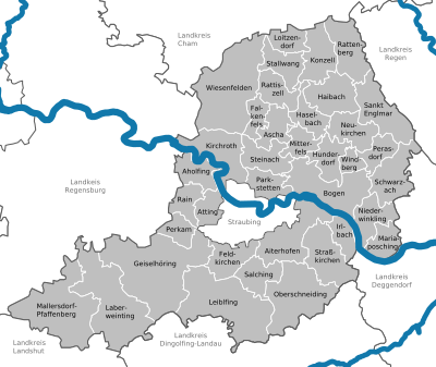
The district of Straubing-Bogen is located in the northwest of the Bavarian administrative district of Lower Bavaria .
geography
location
The Straubing-Bogen district is traversed by the Danube from west to east . It divides the district into two roughly equal parts of different landscapes. North of the Danube, the foreland with the foothills of the Bavarian Forest stretches up to heights of over 1000 m. The Hirschenstein (1092 m) is located on the far eastern edge of the circle . In the Danube lowland there are mainly alluvial forests, meadows and pastures. South of the Danube, the Danube Plain merges into the Danube-Isar hill country . Agriculture is the main activity in the Danube Plain.
In the district, the Große Laber and the Aiterach flow into the Danube from the right and the Kinsach and the Bogenbach from the left.
Neighboring areas
The district borders clockwise (starting in the north) on the districts of Cham , Regen , Deggendorf , Dingolfing-Landau , Landshut and Regensburg . The district also surrounds the city of Straubing , which is its administrative seat.
history
Regional courts
Most of the Straubing-Bogen district used to belong to the Counts of Bogen , but it soon became part of Bavaria. In 1803 the regional courts of Straubing and Mitterfels were established, which belonged to the Regenkreis , later the Lower Danube District , which was renamed Lower Bavaria in 1838 . In the same year the District Court of Bogen was established. Straubing had already become a city in the immediate vicinity of the district in 1809 .
District Offices
In 1862 the Straubing Regional Court became the district office of the same name , and the new Bogen district office comprised the Bogen and Mitterfels regional courts.
Counties
On January 1, 1939, the designation district was introduced as everywhere else in the German Reich . The district offices became the districts of Bogen, Mallersdorf and Straubing.
District of Straubing-Bogen
As part of the regional reform in Bavaria , the new district of Straubing-Bogen was formed on July 1, 1972 from the following components:
- All municipalities of the dissolved district of Straubing
- All municipalities of the dissolved district of Bogen with the exception of the municipality of Bernried
- The communities of Allkofen , Eitting , Geiselhöring , Grafentraubach , Graßlfing , Greißing , Haader , Hadersbach , Haindling , Hainsbach , Hirschling , Hofkirchen , Laberweinting , Mallersdorf , Niederlindhart , Oberhaselbach , Pfaffenberg , Sallach , Upfkofen , Wallkofen and Weichs Mallersdorf of the disbanded district
- The communities of Höhenberg , Niederachdorf , Obermiethnach , Pillnach and Pondorf of the Regensburg district
On May 1, 1978, the community of Großenpinning moved from the district of Dingolfing-Landau to the district of Straubing-Bogen and was incorporated into Oberschneiding .
Population development
From 1988 to 2008, the Straubing-Bogen district grew by over 16,000 inhabitants or around 20%. In the period from 1988 to 2018, the district grew from 81,577 to 100,649 by 19,072 inhabitants or 23.4%. In 11 of 37 municipalities, the population increased by more than 40%, especially in the vicinity of the urban district of Straubing.
The following figures refer to the territorial status on May 25, 1987.
| Population development | ||||||||||||||
|---|---|---|---|---|---|---|---|---|---|---|---|---|---|---|
| year | 1840 | 1900 | 1939 | 1950 | 1961 | 1970 | 1987 | 1991 | 1995 | 2000 | 2005 | 2010 | 2015 | |
| Residents | 56,671 | 65,273 | 70.126 | 90.111 | 74,748 | 78,499 | 81,062 | 85,654 | 90.923 | 95,242 | 97,797 | 97,591 | 98,806 | |
politics
District administrators
- July 1, 1972-30. April 1978: Franz Xaver Hafner ( CSU ), (1948–1972 District Administrator, District Arch)
- May 1, 1978-30. April 2002: Ingo Weiß ( CSU )
- May 1, 2002–30. April 2014 Alfred Reisinger ( CSU )
- since May 1, 2014: Josef Laumer ( CSU )
District council
The local elections from 2002 to 2020 led to the following allocation of seats in the district council:
| 2002 | 2008 | 2014 (invalid) | 2015 | 2020 | |
|---|---|---|---|---|---|
| CSU | 34 | 32 | 31 | 28 | 26th |
| Free voters | 9 | 11 | 12 | 13 | 13 |
| SPD | 8th | 7th | 7th | 7th | 5 |
| ödp / party-free environmentalists | 5 | 5 | 5 | 7th | 6th |
| FDP / Free Voting Group | 2 | 3 | 3 | 3 | 3 |
| REP | 1 | 1 | - | - | - |
| GREEN | 1 | 1 | 2 | 2 | 4th |
| AfD | - | - | - | - | 3 |
| total | 60 | 60 | 60 | 60 | 60 |
The term of office of the district council that emerged from the election on March 16, 2014 ended prematurely, as the election result was declared invalid due to election fraud. The district council's by-election took place on February 1, 2015.
badges and flags
|
|
Blazon : “Divided by a silver wavy strip, above a silver clad and golden crowned Madonna in a golden, twelve-fold halo, on the right by a slanting golden ear of corn and to the left by a slanting golden ear of corn, below, obliquely roughened in silver and blue. " |
|
Justification of the coat of arms: Today's coat of arms was essentially derived from the coats of arms of the earlier districts of Straubing and Bogen.
The Madonna symbol represents the Madonna from Bogenberg and comes from the old Bogener coat of arms, the two ears of corn the fertility of the Gäuboden (green), taken from the Straubing coat of arms. The Bavarian diamonds were part of both district coats of arms, as was the wavy strip that represents the Danube and divides the shield. 
Signs near Reissing
The district adorns itself with the nickname "home of the Bavarian diamond coat of arms". In fact, the white-blue diamond coat of arms (the heraldically relevant, top right corner - from the front top left - contains a piece of white diamond - therefore white-blue and by no means blue-white) goes back to the Counts of Bogen, who lived in the former Altlandkreis Bow were at home. As early as 1247, the Wittelsbach family took over the white and blue coat of arms from the Counts of Bogen and subsequently used it as their main coat of arms. It has been featured as a heart shield in the coat of arms of the Bavarian kings since 1835 and has been a symbol for all of Bavaria ever since. The diamond coat of arms alone is listed as the “ small Bavarian state coat of arms ” and bears the people's crown above the shield. The Straubing-Bogen district is the only district to use a white and blue roughened flag with the district's coat of arms in the banner head. |
Economy and Infrastructure
In the Future Atlas 2016 , the Straubing-Bogen district was ranked 210th out of 402 districts, municipal associations and urban districts in Germany, making it one of the regions with a "balanced risk-opportunity mix" for the future.
traffic
Street

The district is determined by the A 3 connected to the regional road network. In addition, there are four other trunk roads in the district with the B 20 , B 8 , B 15 and B 15n .
train
Four railway lines run through the district:
- the Munich – Regensburg railway line
- the Regensburg – Passau railway line
- the Straubing – Bogen railway line (formerly to Miltach)
- the Neufahrn – Radldorf railway line
The AG der Bayerischen Ostbahnen ran its first connection Regensburg – Landshut – Munich in 1859 via Geiselhöring, where a branch was made towards Straubing , which was continued in the direction of Plattling in 1860.
It was not until 1873 that the detour via Geiselhöring ceased; At almost the same time, the direct line from Regensburg to Landshut via Eggmühl was opened.
The Bavarian State Railroad ran the Straubing – Miltach railway from Straubing in 1895 over the Danube to Bogen and in the following year further into the Bavarian Forest to Konzell Süd; the connection to Miltach followed in 1905.
After the 32 km long line from Bogen via Mitterfels and Konzell-stripau to Miltach into the Bavarian Forest was shut down in the years 1984 to 1994, only 72 km of passenger transport routes are now served in the district instead of 104 km.
Waterway

The entire length of the Danube is a federal waterway through the district .
Airfield
The Straubing-Wallmühle airfield exists in the municipality of Atting .
Communities
(Residents on December 31, 2019)
  |
Other communities
|
court House
.JPG)
The office building of the District Office Straubing-Bogen is located in Straubing , Leutnerstr. 15 near the correctional facility.
As part of Agenda 21 , a “future office” was set up at the district office.
Protected areas
There are seven nature reserves , seven landscape protection areas , ten FFH areas and at least 27 geotopes designated by the Bavarian State Office for the Environment (as of August 2016) in the district.
See also:
- List of nature reserves in the Straubing-Bogen district
- List of landscape protection areas in the Straubing-Bogen district
- List of FFH areas in the Straubing-Bogen district
- List of geotopes in the Straubing-Bogen district
License Plate
On August 5, 1974, the district was assigned the distinctive sign SR , which has been valid for the Straubing district since July 1, 1956 . It is still issued today.
In contrast to the independent city of Straubing, the SR is followed by two letters (for the city of Straubing this is one).
The outgoing District Administrator Reisinger categorically rejected the reintroduction of the old license plates MAL (for Mallersdorf) and BOG (for arches) as part of the license plate liberalization until the end of his term of office. Since the end of July 2014, however, the MAL label has been issued in the neighboring district of Landshut.
Since July 2, 2018, the distinctive signs BOG and MAL have also been available in the Straubing-Bogen district.
literature
- Franz X. Bogner: The district of Straubing-Bogen from the air . Verlag Attenkofer, Straubing 2018, ISBN 978-3-947029-01-3 .
Web links
- Official website of the district
- Tourist website of the district
- Literature from and about the district of Straubing-Bogen in the catalog of the German National Library
- Entry on the coat of arms of the Straubing-Bogen district in the database of the House of Bavarian History
Individual evidence
- ↑ "Data 2" sheet, Statistical Report A1200C 202041 Population of the municipalities, districts and administrative districts 1st quarter 2020 (population based on the 2011 census) ( help ).
- ^ Wilhelm Volkert (ed.): Handbook of Bavarian offices, communities and courts 1799–1980 . CH Beck, Munich 1983, ISBN 3-406-09669-7 , p. 97 .
- ^ Ordinance on the reorganization of Bavaria into rural districts and independent cities of December 27, 1971
- ^ Federal Statistical Office (ed.): Historical municipality directory for the Federal Republic of Germany. Name, border and key number changes in municipalities, counties and administrative districts from May 27, 1970 to December 31, 1982 . W. Kohlhammer GmbH, Stuttgart / Mainz 1983, ISBN 3-17-003263-1 , p. 632 and 633 .
- ↑ The district council of the Straubing-Bogen district. (No longer available online.) District Office Straubing-Bogen, archived from the original on September 13, 2013 ; Retrieved January 18, 2015 . Info: The archive link was inserted automatically and has not yet been checked. Please check the original and archive link according to the instructions and then remove this notice.
- ↑ Press release 402/2014. Government of Lower Bavaria, November 12, 2014, accessed January 18, 2015 .
- ↑ Entry on the coat of arms of the Straubing-Bogen district in the database of the House of Bavarian History , accessed on September 5, 2017 .
- ↑ Entry on the district of Straubing-Bogen on the website kommunalflaggen.eu
- ↑ Future Atlas 2016. (No longer available online.) Archived from the original on October 2, 2017 ; accessed on March 23, 2018 . Info: The archive link was inserted automatically and has not yet been checked. Please check the original and archive link according to the instructions and then remove this notice.
- ↑ "Data 2" sheet, Statistical Report A1200C 202041 Population of the municipalities, districts and administrative districts 1st quarter 2020 (population based on the 2011 census) ( help ).
- ↑ District Administrator has decided: SR remains the sole indicator. Passauer Neue Presse, April 9, 2013, accessed on September 2, 2016 .
- ↑ Source: Landshut District Office
Districts:
Aichach-Friedberg |
Altötting |
Amberg-Sulzbach |
Ansbach |
Aschaffenburg |
Augsburg |
Bad Kissingen |
Bad Toelz-Wolfratshausen |
Bamberg |
Bayreuth |
Berchtesgadener Land |
Cham |
Coburg |
Dachau |
Deggendorf |
Dillingen on the Danube |
Dingolfing-Landau |
Danube Ries |
Ebersberg |
Eichstätt |
Erding |
Erlangen-Höchstadt |
Forchheim |
Freising |
Freyung-Grafenau |
Fürstenfeldbruck |
Fürth |
Garmisch-Partenkirchen |
Gunzburg |
Hatred Mountains |
Yard |
Kelheim |
Kitzingen |
Kronach |
Kulmbach |
Landsberg am Lech |
Landshut |
Lichtenfels |
Lindau (Lake Constance) |
Main-Spessart |
Miesbach |
Miltenberg |
Mühldorf am Inn |
Munich |
Neuburg-Schrobenhausen |
Neumarkt in the Upper Palatinate |
Neustadt an der Aisch-Bad Windsheim |
Neustadt an der Waldnaab |
Neu-Ulm |
Nuremberg Country |
Oberallgäu |
Ostallgäu |
Passau |
Pfaffenhofen an der Ilm |
Rain |
Regensburg |
Rhön-Grabfeld |
Rosenheim |
Roth |
Rottal-Inn |
Schwandorf |
Schweinfurt |
Starnberg |
Straubing Arch |
Tirschenreuth |
Traunstein |
Unterallgäu |
Weilheim-Schongau |
Weißenburg-Gunzenhausen |
Wunsiedel in the Fichtel Mountains |
Wurzburg
Independent cities:
Amberg |
Ansbach |
Aschaffenburg |
Augsburg |
Bamberg |
Bayreuth |
Coburg |
Erlangen |
Fürth |
Hof (Saale) |
Ingolstadt |
Kaufbeuren |
Kempten (Allgäu) |
Landshut |
Memmingen |
Munich |
Nuremberg |
Passau |
Regensburg |
Rosenheim |
Schwabach |
Schweinfurt |
Straubing |
Willows in the Upper Palatinate |
Wurzburg