
Federal motorway 62
| Bundesautobahn 62 in Germany | |||||||||||||||||||||||||||||||||||||||||||||||||||||||||||||||||||||||||||||||||||||||||||||||||||||||||||||||||||||||||||||||||||||||||||||||||||||||||||||||||||

|
|||||||||||||||||||||||||||||||||||||||||||||||||||||||||||||||||||||||||||||||||||||||||||||||||||||||||||||||||||||||||||||||||||||||||||||||||||||||||||||||||||
| map | |||||||||||||||||||||||||||||||||||||||||||||||||||||||||||||||||||||||||||||||||||||||||||||||||||||||||||||||||||||||||||||||||||||||||||||||||||||||||||||||||||
 |
|||||||||||||||||||||||||||||||||||||||||||||||||||||||||||||||||||||||||||||||||||||||||||||||||||||||||||||||||||||||||||||||||||||||||||||||||||||||||||||||||||
| Basic data | |||||||||||||||||||||||||||||||||||||||||||||||||||||||||||||||||||||||||||||||||||||||||||||||||||||||||||||||||||||||||||||||||||||||||||||||||||||||||||||||||||
| Operator: |
|
||||||||||||||||||||||||||||||||||||||||||||||||||||||||||||||||||||||||||||||||||||||||||||||||||||||||||||||||||||||||||||||||||||||||||||||||||||||||||||||||||
| Start of the street: |
Autobahn triangle Nonnweiler ( 49 ° 36 ′ N , 6 ° 59 ′ E ) |
||||||||||||||||||||||||||||||||||||||||||||||||||||||||||||||||||||||||||||||||||||||||||||||||||||||||||||||||||||||||||||||||||||||||||||||||||||||||||||||||||
| End of street: |
Höheischweiler ( 49 ° 13 ′ N , 7 ° 33 ′ E ) |
||||||||||||||||||||||||||||||||||||||||||||||||||||||||||||||||||||||||||||||||||||||||||||||||||||||||||||||||||||||||||||||||||||||||||||||||||||||||||||||||||
| Overall length: | 79 km | ||||||||||||||||||||||||||||||||||||||||||||||||||||||||||||||||||||||||||||||||||||||||||||||||||||||||||||||||||||||||||||||||||||||||||||||||||||||||||||||||||
|
State : |
|||||||||||||||||||||||||||||||||||||||||||||||||||||||||||||||||||||||||||||||||||||||||||||||||||||||||||||||||||||||||||||||||||||||||||||||||||||||||||||||||||
 |
|||||||||||||||||||||||||||||||||||||||||||||||||||||||||||||||||||||||||||||||||||||||||||||||||||||||||||||||||||||||||||||||||||||||||||||||||||||||||||||||||||
| Bundesautobahn 62 with exit Freisen | |||||||||||||||||||||||||||||||||||||||||||||||||||||||||||||||||||||||||||||||||||||||||||||||||||||||||||||||||||||||||||||||||||||||||||||||||||||||||||||||||||
|
Course of the road
|
|||||||||||||||||||||||||||||||||||||||||||||||||||||||||||||||||||||||||||||||||||||||||||||||||||||||||||||||||||||||||||||||||||||||||||||||||||||||||||||||||||
The federal autobahn 62 (abbreviation: BAB 62 ) - short form: Autobahn 62 (abbreviation: A 62 ) - is a German autobahn that leads from the triangle Nonnweiler to Pirmasens . In doing so, it bypasses the greater Saarbrücken area and provides a direct connection between the Eifel region around Trier and the south-west German metropolitan areas.
Since the formerly planned section Saarbrücken - Karlsruhe of the Federal Motorway 8 through the Palatinate Forest was never built, it can only partially fulfill this task, which is why the route mostly has little traffic. The section between Landstuhl and Pirmasens is therefore partially developed only on one lane with oncoming traffic and is signposted as a motor road due to this development status.
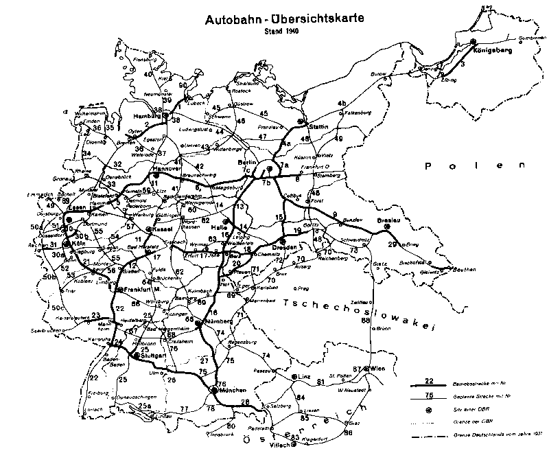
The route was planned as part of a Reichsautobahn from Cologne via Trier to the Reichsautobahn Saarbrücken- Mannheim near Landstuhl at the time of National Socialism . Construction on the first section finally began in the 1960s. The completion dragged on in sections over many years until 1991.
course
The BAB 62 begins as a continuation of the carriageway of the BAB 1 coming from Trier at the Nonnweiler triangle . If you want to continue on the latter in the direction of Saarbrücken , you have to leave the lane there. Since the triangle itself only has ramps from and to the west or north (Trier), the adjacent Nonnweiler - Otzenhausen junction serves as a replacement for the route BAB 62 – Saarbrücken . After a few hundred meters on the state road, you will come to the BAB 1 in a southerly direction.
The first kilometers of the motorway lead through the Saarland along the southern edge of the Black Forest high forest . Shortly before Birkenfeld it changes to the federal state of Rhineland-Palatinate for the first time , leads in sections along the border between the two federal states and changes this several times before finally leaving the Saarland at Reichweiler . The motorway reaches the North Palatinate Bergland and leads east to south-east through the rural region until the Landstuhler Bruch plain begins behind Glan-Münchweiler .
At the Landstuhl-West junction , the BAB 6 (Saarbrücken - Mannheim - Nuremberg - Waidhaus ) is crossed. The route then climbs steeply south of the crossing structure, leaves the Landstuhler Bruch and leads with a tunnel structure to the Westrich plateau . After the Bann junction , the two-lane expansion ends and from here on, the BAB 62 is only completed on the eastern carriageway, which is operated in one lane with two-way traffic. The full expansion with a second carriageway was already prepared during construction, but is very unlikely due to the very low volume of traffic in this area.
The single-lane section, which is signposted as a motor road with yellow signs, now leads over the plateau on the western edge of the Palatinate Forest to Pirmasens . The second lane has now been built on a section of just a few kilometers near Höheinöd to allow overtaking. Shortly before Pirmasens , a deep valley is crossed on the 100 m high Schwarzbachtalbrücke , the highest bridge structure on the route. The Pirmasens junction provides a connection to the B 10 in the direction of Landau , which serves as an alternative route between Saarland and Baden-Württemberg and Bavaria .
The short section between the Pirmasens and Pirmasens-Winzeln junctions has again been extended to two-lane motorway standards and has blue signs. The Pirmasens-Winzeln junction was originally built as a preliminary service for a motorway triangle with the BAB 8 in the direction of Karlsruhe , whereby only the ramps for the Landstuhl – Neunkirchen route were built. After the planning for the further construction was given up, a junction was integrated into the roadway separation in the 2000s. To the southwest of this junction, the route continues as BAB 8 in the direction of Neunkirchen and Zweibrücken .

Start of the motorway at the Nonnweiler triangle

At Birkenfeld

At the Landstuhl-West cross

_-_geo.hlipp.de_-_23944.jpg)
_-_geo.hlipp.de_-_27903.jpg)
_neu.jpg)
history
1930s and 1940s: Reichsautobahn construction and advance payments
The network of the Reichsautobahn , which was essentially based on plans by the HaFraBa association in the 1920s, was intensively promoted by the National Socialists who came to power in January 1933 under the leadership of Adolf Hitler . At the end of the 1930s, planning provided for a north-south route from Cologne via Trier to Landstuhl , which was to flow into the Saarbrücken- Mannheim Reichsautobahn (today's BAB 6 ), which was also under construction at the time , between Saarbrücken and Kaiserslautern .
The last-mentioned route - the Reichsautobahn Saarbrücken – Mannheim - was built as route 38 from 1934 onwards. While the eastern end of this motorway route near Viernheim was to flow into the Frankfurt am Main – Mannheim– Heidelberg motorway, which was completed in 1935 as the first Reichsautobahn of the Nazi era , the western end was initially under construction as far as Landstuhl . The first section of this line went into operation on October 24, 1937, the Kaiserslautern-West-Wattenheim section, which continued to run east from Wattenheim to Frankenthal until 1940 and continued west from Kaiserslautern-West to Landstuhl until 1941, sometimes with only one lane , followed. The last section between Frankenthal and Viernheim with a bridge over the Rhine was no longer in operation because of the outbreak of World War II , in the course of which work on all motorway construction sites was stopped.
At the western end of the expansion near Landstuhl, preliminary work was already carried out for a motorway junction with the Reichsautobahn coming from Trier. First and foremost, it was earthworks that served as preparation for a motorway junction in the shape of a clover leaf. Both on the continuation to Saarbrücken and on the line to Trier, preparatory work was carried out in this area on the route in sections, so that a provisional connection to Landstuhl remained. In any case, the section of the Reichsautobahn between Kaiserslautern and Landstuhl had never really been opened to public traffic, as the route built especially for this reason near Ramstein-Miesenbach was used as a provisional runway for aircraft.
On the Cologne – Trier – Landstuhl line itself, construction began on the first section between Kaisersesch and Wittlich in September 1939 . Forced laborers from the Wittlich prison , the Hinzert concentration camp , Luxembourg, as well as Polish and Soviet prisoners of war, who were interned in barracks along the way, were employed for the construction work . About 13.6 km of the route between Hasborn and Wittlich-Dorf could be driven on one directional lane until 1941. Here, too, the Second World War brought the construction work to a standstill, so that the earthworks on the route were finished on most of the route under construction at the time, but the route lay fallow.
To the south of Trier, between Freisen and Landstuhl, earthworks were already being carried out in part together with the construction of the Saarbrücken – Mannheim motorway, but no section was passable until the construction work was stopped due to the war.
post war period
After the end of the Second World War, the restoration of the motorway network began quickly. Numerous bridge structures destroyed by the Wehrmacht in the last days of the war were initially rebuilt as makeshifts, then with permanent new buildings, and the first sections of the autobahn that were no longer completed before the war were completed - for example, in 1950 the Rhine bridge near Ludwigshafen with the name Theodor-Heuss -Bridge .
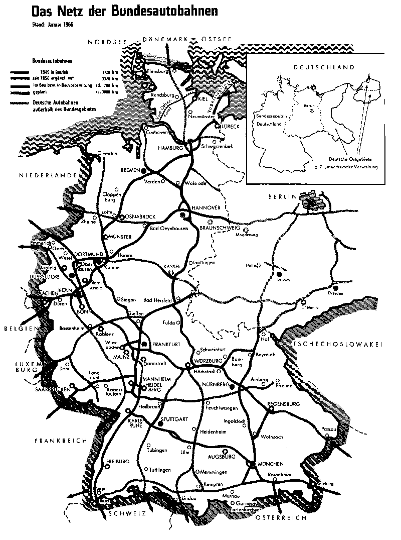
After the end of the war, the US military occupied the section of the Reichsautobahn between Landstuhl and Kaiserslautern, which was designed as a military airfield, and from the late 1940s built its own air force base, which was expanded to include a runway and numerous buildings along the Reichsautobahntrasse. Today's Ramstein Air Base developed from this . When the motorway in the direction of Saarbrücken was further built in the 1950s, it was given a new route, which was led around the air base in a wide arc to the south - after 1945 there was initially a temporary bypass of the motorway airfield on the old route for a few years. The new section ended initially in Waldmohr , just before the border with the then autonomous and economically with France related Saarland . It was not until 1959, two years after the Saarland joined the Federal Republic of Germany, that the autobahn continued, initially to St. Ingbert , and in 1963 to Saarbrücken.
The motorway junction at Landstuhl, which had already been partially built, was no longer used in its existing form when the new route was built. Instead, a permanent junction was created here, which was, however, already prepared for a height-free connection to another motorway - so, due to the changed route in the direction of Kaiserslautern, the crossing structure was not possible, but the one between Freisen and Landstuhl that was already established and was partially before the war The route under construction can be used for the motorway to be connected in the direction of Trier.
The political and economic accession of the Saarland to the Federal Republic of Germany made it necessary to re-plan the Trier – Landstuhl line in order to guarantee an efficient connection to the Saarland trunk road network, which was completely redesigned after the war. The pre-war planning envisaged a route bypassing the Saarland, so that the only motorway connection to the greater Saarbrücken area would have been via the Reichsautobahn coming from Mannheim. In the autonomous Saarland, an intersection-free, two- to four-lane long-distance road was finally planned, which would lead from Saarbrücken to the north and thereby provide an efficient connection to the northern Saarland.
Since a connection in the north to the Trier – Landstuhl line was planned, the plans for the latter line had to be completely revised. With the law on the expansion plan for the federal highways of 1957, the completion of this route as a simple federal road (sometimes called federal road 408 ) was provided. The connection to the Saarland trunk road, since 1957 run as the B 327 and partially B 268 , was to take place in the Saarland area near Nonnweiler . The first section of this road opened in 1960 between Saarbrücken- Malstatt and Riegelsberg .
1960s and 1970s: construction continued
Freisen – Landstuhl
Network plans from the 1960s envisaged a continuation of the line coming from Trier via Landstuhl to Pirmasens . The motorway coming from Koblenz, which at that time was under construction or partially already completed as far as Wittlich , was supposed to continue from Trier to Luxembourg . The route to Landstuhl / Pirmasens should then branch off northeast of Trier.
In the numbering system at that time, which was only used internally (on the motorway signs themselves, in addition to long-distance destinations, only the European roads were signposted), a motorway from Trier via Landsuhl to Pirmasens, later to Stuttgart , was planned under the designation A 76 . Between Schweich (branch of the Dernbach – Koblenz – Luxemburg route) and Freisen, the newly planned route via Nonnweiler with connection to the expressway in the direction of Saarbrücken was to be used, and from Freisen the route to the Mannheim – Saarbrücken motorway, which was prepared before the Second World War, was to be used Landstuhl.
In the 1960s, after the motorway from Mannheim to Saarbrücken was completely passable, the construction of the line from Landstuhl to Trier was continued. The prepared route could be used for further construction, but longitudinal slopes and curve radii were modified according to modern knowledge, which resulted in a more curved line and less steep inclines and slopes. Initially, work was carried out in the approximately 8 km long section between Landstuhl and Glan-Münchweiler , which was opened to traffic on September 6, 1966. As before the war, the southern end was designed as a temporary transition to the secondary road network (L 395). The junction with the Mannheim – Saarbrücken route, which at that time had the number A 20 , was designed in the shape of a cloverleaf, but with adapted ramps and parallel lanes only on the A 20.
Four years later, on December 28, 1970, the motorway was extended in a northerly direction by nine kilometers to the Kusel junction and another year and a half later, on July 26, 1972, by 6.1 km to the Reichweiler junction. In the following year 1973, 2.7 km were finally completed to the Freisen junction . In the area of the route in which the route was already being built before the Second World War, the motorway was therefore passable around 30 years after the first work began.
At that time, the transport benefits were still largely limited to regional transport, as the villages and small towns in the West Palatinate and the North Palatinate Uplands could now be reached more quickly. A larger traffic importance it has, up to the present time, but for troop movements of the US Army - at the southern end of the highway is on the junction Hütschenhausen the Ramstein Air Base attainable, also exists in Landstuhl military hospital Landstuhl Regional Medical Center . At what was then the northern end near Freisen is the Baumholder military training area , which is used not only by the Bundeswehr but also by soldiers from the US Army and other NATO member states. The Freisen junction in a northerly direction (east side of the road) is therefore unusual, as it also has a very wide hard shoulder in the area of the deceleration lane. The reason was the convoy of the military into nearby Baumholder, who could use this area as a parking area in the event of a backlog.
Planned route Landstuhl – Pirmasens – Karlsruhe – Stuttgart
The A 76 was planned as a supplementary route between the Rhineland and southern Germany at the end of the 1960s . In addition to connecting the structurally weak area in the western Eifel and Hunsrück regions , it was intended to be an alternative to long-distance traffic both to the Cologne – Frankfurt – Mannheim – Karlsruhe main line, which was largely completed before the war, using the Frankfurt Cross , and to the Left Rhine line, which was then under construction , a motorway from Krefeld via Koblenz to Ludwigshafen . In addition, it would create a direct connection between the Aachen area and the southern German states of Bavaria and Baden-Württemberg , avoiding the Cologne Ring, which was closed in 1965 .
South of Landstuhl, the motorway was to run on a completely newly planned route to Pirmasens, where a motorway was to branch off towards Neunkirchen and Zweibrücken . This was already prepared when the motorway between Kaiserslautern and Saarbrücken was completed in 1959 as a feeder road to Limbach . After Pirmasens, the autobahn should then swivel to the southeast and run through the Palatinate Forest near the French border , before the Bienwald should be crossed and the Rhine should be crossed. The Frankfurt – Basel motorway was to be crossed south of Karlsruhe and, parallel to the Karlsruhe – Munich motorway from the 1930s, was to be passed south of Pforzheim . This motorway would have crossed east of Pforzheim and would continue to run parallel to the north of the existing route into the Stuttgart city area.
On January 30, 1970, the A 76 was included in the requirement plan.
Introduction of the name Bundesautobahn 62
On January 1, 1975, a new, uniform numbering scheme was introduced for the motorways in the Federal Republic of Germany and West Berlin. Initially, only internally managed numbering was used and only the numbers of the European roads running along the route were indicated on the signposts, but the new national numbering was brought forward. A previously in demand plan national highways 1971-1985 described system, the by Berliner Ring the digit numbers A 1 zuordnete branching routes to A 6, could, also in view of the then still existing German division , not prevail.
A great advantage of the system, that also the leading number of two- and three-digit motorways assigned to a certain region, was that in the event of reunification , numbers could already be assigned for the motorway routes in the former GDR without any problems (these were essentially the ones previously for the West Berlin city highways assigned numbers in the 10 range).
The route Trier – Pirmasens – Karlsruhe – Stuttgart, planned as the A 76 , was divided into different autobahns in the new numbering scheme: Between Trier and Nonnweiler as part of the north-south axis of the federal autobahn (BAB) 1, between Pirmasens and Stuttgart as part of the east-west -Axis BAB 8, east of Pforzheim as BAB 82 . The rest of the route between Nonnweiler and Pirmasens was given the number BAB 62. Although the intended route of this motorway tends more in a north-south direction, an even number was assigned for east-west routes. At the time of the renumbering, only the Freisen – Landstuhl section was completed, which follows a north-west-south-east course.
Extension of Landstuhl - Pirmasens
In the mid-1970s, the planned construction of the Palatinate Forest and Albga line between Pirmasens and Karlsruhe as part of the BAB 8 became more and more controversial. Especially the section between Karlsruhe and Pforzheim, which was supposed to run on the slope of the northern Black Forest, would have been very expensive with numerous large bridges and the crossing of the mountainous terrain. With the requirements plan of the law amending the law on the expansion of federal highways from 1971 to 1985 from August 5, 1976, the construction of a second connection between Karlsruhe and Stuttgart was abandoned in favor of a six-lane expansion of the existing motorway.
The first preparatory work for the Landstuhl – Pirmasens section was carried out at the end of the 1970s. It was assumed that this section, together with the planned federal motorway 8 between Pirmasens and Karlsruhe, would enable a fast connection between southern Germany and the Eifel region, the western Rhineland and the Benelux countries while avoiding high-traffic conurbations. Thus, in 1978, the construction of the 600 m long and 100 m high Schwarzbachtal Bridge began, in which initially only one bridge structure was built for one carriageway.
At the end of 1979, the construction of the bridge was estimated at 16.1 million DM . Due to the initially expected low volume of traffic, the construction between Landstuhl and Pirmasens was initially only planned on the eastern carriageway (direction Trier). At a later point in time, for example when the BAB 8 Pirmasens – Karlsruhe is completed, the motorway should then be supplemented by the second lane. For the construction of the 27.4 km long route between the Landstuhl-West intersection and Pirmasens, the total costs were estimated at 286.3 million DM.
In addition to the construction of the Schwarzbachtal bridge, construction work was also carried out on a one -way carriageway in the area between the Thaleischweiler-Fröschen and Pirmasens junctions . This work took place together with the construction of the Walshausen –Pirmasens section of the A8 motorway. At this point in time the BAB 8 was already under traffic from Friedrichsthal to Walshausen, with which there was a direct connection to Saarbrücken and France via the Neunkirchen junction and the BAB 6 . At the planned meeting point of BAB 8 and BAB 62, a lane separation was created as a preliminary construction work for a later motorway triangle - the BAB 62 would branch off from the main carriageway between Saarbrücken and Karlsruhe in the direction of Trier. The lane separation should represent the ramps of the Saarbrücken – Trier relation.
On the short stretch from the planned motorway triangle to the first junction in the north, which connects the B 10 to the Pirmasens city center, the BAB 62 was fully upgraded on both lanes. The subsequent section to the Thaleischweiler-Fröschen junction, however, was only completed on the eastern carriageway. The Walshausen – Pirmasens – Thaleischweiler-Fröschen BAB 8 and BAB 62 routes opened in 1981. In the same year, construction work on the Schwarzbachtalbrücke was completed, but this area, which adjoins the newly opened section, has not yet been included started the road construction.
With the second law amending the law on the expansion of federal highways from 1971 to 1985 from August 25, 1980 , the construction of the Pirmasens – Karlsruhe section of the BAB 8 was classified as a reserved route and no longer included in the requirement plan. A few years later, the route was abandoned altogether, instead a high-performance connection was to be established along the B 10 between Pirmasens and Landau and the BAB 65 coming from Ludwigshafen should be led across Kandel , south past Karlsruhe to the BAB 5 near Bruchhausen . For environmental reasons - in the area of the Rhine crossing, protected wetlands would have been destroyed - in the mid-1980s, planning was no longer continued here either.
Closing the gap between Nonnweiler and Freisen
Closing the gap between Nonnweiler and Freisen dragged on for several years. The BAB 1 in the Trier – Saarbrücken section was built in the 1970s and opened to traffic on October 20, 1975 between Reinsfeld and Eppelborn . By 1977 it was connected to the high-speed road to Saarbrücken, which was now expanded to four lanes and which had been a motorway since 1969 (section Nonnweiler – Saarbrücken, initially A 171 , from 1975 BAB 1).
The 9.4 km long section between Freisen and Birkenfeld was the first in 1980 to be completed in the course of closing the gap. Construction at the end of the 1970s was very complex in this area, as an approximately 40 m deep cut into the terrain was created for the motorway, which slopes down from the Freisener Höhe into the upper Nahe valley. In the course of the extensive earthmoving, agates were found , at times the motorway construction site and the surrounding area was the largest agate discovery site in Europe. Numerous finds have been exhibited in the Freisen Mineral Museum since 1993.
The section between the Nonnweiler triangle and the Nohfelden - Türkismühle junction was opened on January 4, 1981. The original planning of a continuously numbered A 76 motorway from Trier via Landstuhl to Pirmasens, as it was planned before 1975, can still be traced back to this day based on the continuous lane in the Nonnweiler triangle, which was partially completed in 1975 - coming from Trier you have to turn off at the Nonnweiler triangle In order to stay on the BAB 1, the continuous lane leads to the BAB 62. The connection from the BAB 62 to the BAB 1 in the south is made indirectly via the junction Nonnweiler-Otzenhausen. During the construction of the BAB 1 and the BAB 62, the dam for the nearby Primstalsperre was created in two phases from 1973 to 1975 and 1979 to 1982, respectively, from the spoil from the motorway construction .
The last section in the northern part was the 6.3 km long route between the Nohfelden-Türkismühle and Birkenfeld junctions. The BAB 62 was thus continuously completed between Nonnweiler and Landstuhl, together with the triangle Moseltal- Reinfeld section of the BAB 1, which has been in operation since 1983 , there has been a continuous motorway connection between Trier and Landstuhl, where the BAB 6 connects with southern Germany . In addition, together with the BAB 1 to Daun and the BAB 48, a ring closure in western Rhineland-Palatinate was completed, which opens up the Eifel region better
Closing the gap between Landstuhl and Pirmasens
In the 1980s, the section from Landstuhl-West to Pirmasens was completed with a one-way carriageway on most of the route. The motorway on the eastern lane between Weselberg and Thaleischweiler-Fröschen went into operation in 1985 after the Schwarzbachtal bridge was completed in 1981. At Höheinöd , rest areas were created on both sides of the carriageway, which were connected to the secondary road network on both sides with a service access road.
The completion of the last section between the Landstuhl-West and Weselberg junctions took several years. The ascent from the Landstuhler Bruch to the plateau of the Westrich , which is laborious to build, requires two valley bridges and a tunnel structure. On July 21, 1986, the tunnel was erected for the approximately 500-long Hörnchenberg tunnel , the shell of which was completed in 1989 after three years of construction. The section from Landstuhl-West to shortly after the Bann junction was built with two lanes from the start - among other things, the Hörnchenberg tunnel could go into operation with both tubes - and the continuation to Weselberg to the already existing, single-lane section was also only built on the eastern directional carriageway.
Action Lindwurm
In July and August 1990, the US Army withdrew poison gas grenades from the NATO Site 59 depot at Clausen near Pirmasens in order to transport them to the Johnston Atoll in the Pacific Ocean for destruction . The route was supposed to lead from Clausen to the Army Depot near Miesau , then via the local railway connection to Nordenham and finally by ship to the Pacific. For the route from Clausen to Miesau by road, three options were considered - via the BAB 8 and BAB 6 via the Neunkirchen junction , the BAB 62, which is still under construction, or the B 270 and BAB 6 via Kaiserslautern . Among other things, because of the minor disruption to ongoing traffic along the BAB 62, which is not yet or only partially completed, this route was chosen.
At the time of removal, the Hörnchenberg tunnel had already been completed, and the route to the south of the tunnel to Weselberg was also passable. The viaduct was only still under construction between the Landstuhl-West junction and the tunnel, so a provisional gravel road was heaped up on which the military truck convoy drove.
The section Landstuhl-West to Weselberg was finally opened to traffic on September 6, 1991. The provisional junction Landstuhl-West , where the BAB 62 south of the motorway junction with the BAB 6 merged into the secondary road network, was converted into a fork and is only accessible from or to the north.
List of traffic clearances
| section | year | km | comment |
|---|---|---|---|
| Triangle Nonnweiler - AS Türkismühle | 1981 | 8.2 km | |
| AS Türkismühle - AS Birkenfeld | 1988 | 6.3 km | |
| AS Birkenfeld - AS Freisen | 1980 | 9.4 km | |
| AS Freisen - AS Reichweiler | 1973 | 2.7 km | |
| AS Reichweiler - AS Kusel | 1972 | 6.1 km | |
| AS Kusel - AS Glan-Münchweiler | 1970 | 9.0 km | |
| AS Glan-Münchweiler - Landstuhl-West (prov. Connection) | 1968 | 8.0 km | |
| Landstuhl-West (prov. Connection) - AS Weselberg | 1991 | 13.2 km | Section Bann – Weselberg only east carriageway |
| AS Weselberg - AS Thaleischweiler-Fröschen | 1985 | 9.0 km | initially only east carriageway , since 2014 the second carriageway has been completed on a short section near Höheinöd |
| AS Thaleischweiler-Fröschen - AS Pirmasens-Winzeln (transition to BAB 8) | 1981 | 6.9 km | Section Thaleischweiler-Fröschen-Pirmasens only east carriageway |
expansion
From September 2013 to November 2014, the second carriageway was built over a length of 3.6 km between the Weselberg junction and the Schwarzbachtal bridge (near Höheinöd ). The expansion is intended to prevent dangerous turning maneuvers from the parking lot and at the same time make overtaking easier.
In the course of a full closure of the route between the Bann and Thaleischweiler-Fröschen junctions from mid-January to December 2018, the 16 km roadway was completely renovated, the Schwarzbachtal bridge repaired and the previous Sickinger Höhe car park converted into a junction. A total of almost 30 million euros flowed into this project.
In the Federal Transport Infrastructure Plan 2030 , a two-lane expansion of the previously single-lane sections is no longer planned ( Federal Law Gazette 2016 I p. 3354 , list of projects in Rhineland-Palatinate).
Toll
Truck tolls also have to be paid in the Landstuhl – Pirmasens section , as the route is officially not a motorway, but is still designated as a federal motorway , and the toll applies on federal motorways, regardless of whether the route is a motorway or not.
Individual evidence
- ↑ Motorway overview map. Status: 1940. Accessed April 15, 2013 (map).
- ↑ 8th meeting in Landstuhl May 16-18, 2003 , Arbeitsgemeinschaft Autobahngeschichte (AGAB) eV
- ^ Memories of a sunken world: Page 77 , www.hasborn.de
- ↑ On the topographic maps 1: 25,000 on [1] on landkartenarchiv.de, sheets 6409 (Freisen), 6410 (Kusel), 6510 (Glan-Münchweiler), 6511 (Landstuhl) you can see the state of construction achieved in the post-war period
- ^ History of the A1 / A48 Saarbrücken - Trier - Koblenz , autobahn-online.de
- ^ Reference in the Federal Law Gazette 1957, No. 45 of August 16, 1957 , page 1201, project No. 10
- ↑ Network plan 1966 , autobahn-online.de
- ↑ Numbering of the German motorway network based on the western model before 1974 (incomplete) , autobahn-online.de
- ↑ 'My' Sickingenstadt Landstuhl , landstuhl.info
- ↑ Compilation of the 1968 traffic releases on autobahn-online.de
- ↑ Compilation of the traffic clearances 1970 on autobahn-online.de
- ^ Theo Schäfer: Turquoise mill - Kusel. The railway connection between Nahe and West Palatinate , publishing house and book delivery company Helene + Theo Schäfer, 2006
- ↑ Compilation of the 1972 traffic releases on autobahn-online.de
- ↑ Compilation of the 1973 traffic releases on autobahn-online.de
- ^ Gunther Schüssler: Economy and traffic in the Ostertal . Im St. Wendeler Land, XIV. Edition 1974, Im Ostertal
- ↑ Network plan 1972 , autobahn-online.de
- ↑ a b c A 8 Albgaulinie Karlsruhe - Stuttgart , autobahn-online.de
- ↑ The Rheinpfalz: Autobahn 62 becomes a permanent construction site. August 21, 2017, accessed August 4, 2020 .
- ↑ a b Schwarzbachtalbrücke (A62) , Thaleischweiler-Fröschen local dictionary
- ^ Road construction report 1981 , German Bundestag
- ↑ Compilation of the traffic clearances 1980 on autobahn-online.de
- ↑ SaarZeitung: The beautiful stones from Freisen. February 21, 2017, accessed August 12, 2020 .
- ↑ nailizakon.com: History of Nonnweiler, Saarland in photos. Retrieved August 12, 2020 .
- ↑ Compilation of the traffic clearances 1981 on autobahn-online.de
- ^ Road construction report 1988, p. 24 , German Bundestag
- ^ "The stuff is in Clausen" Newspaper report on the 25th anniversary of Aktion Lindwurm, July 28, 2015
- ↑ Compilation of the 1991 traffic releases on autobahn-online.de
- ^ The fire brigade association: An insight into the field of activity , Landstuhl volunteer fire brigade
- ↑ List of traffic clearances
- ^ A 62: Expansion work at Höheinöd ( memento from March 25, 2016 in the Internet Archive ) LBM Kaiserslautern
- ^ A 62: Free travel on four lanes of the Pirmasenser Zeitung from November 15, 2014
- ↑ Pfälzischer Merkur: The A 62 motorway becomes a major construction site. July 16, 2017, accessed August 16, 2020 .
