Belles-Forêts
| Belles-Forêts | ||
|---|---|---|

|
|
|
| region | Grand Est | |
| Department | Moselle | |
| Arrondissement | Sarrebourg-Château-Salins | |
| Canton | Sarrebourg | |
| Community association | Sarrebourg Moselle Sud | |
| Coordinates | 48 ° 48 ' N , 6 ° 54' E | |
| height | 215-290 m | |
| surface | 26.57 km 2 | |
| Residents | 245 (January 1, 2017) | |
| Population density | 9 inhabitants / km 2 | |
| Post Code | 57930 | |
| INSEE code | 57086 | |
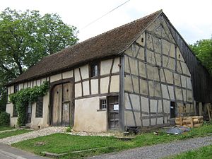
 Maison du Clement , half-timbered house museum |
||
Belles-Forêts is a French commune with 245 inhabitants (as of January 1, 2017) in the Moselle department in the Grand Est region (until 2015 Lorraine ).
geography
The municipality of Belles-Forêts is located on the Saar Canal , about 14 kilometers northwest of Sarrebourg . The municipality is part of the Lorraine Regional Nature Park . The numerous ponds and ponds are characteristic of the area. The Nolweyer, Chirrweyer and Breiweyer ponds are located in the area of the municipality .
history
The municipality Belles-Forêts was created on September 8, 1973 and consists of the two villages Angviller-lès-Bisping ( Angweiler ), which was first mentioned in 775 as Hiohannivillare , and Bisping ( Bisping ). Until January 1, 1986, the place Desseling was one of them.
The place name refers to the extensive forest areas that make up the municipality mainly.
Population development
| year | 1962 | 1968 | 1975 | 1982 | 1990 | 1999 | 2007 |
| Residents | 286 | 280 | 231 | 227 | 242 | 238 | 258 |
