
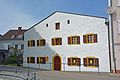
Cham (Upper Palatinate)
| coat of arms | Germany map | |
|---|---|---|

|
Coordinates: 49 ° 13 ' N , 12 ° 40' E |
|
| Basic data | ||
| State : | Bavaria | |
| Administrative region : | Upper Palatinate | |
| County : | Cham | |
| Height : | 370 m above sea level NHN | |
| Area : | 80.67 km 2 | |
| Residents: | 16,990 (Dec. 31, 2019) | |
| Population density : | 211 inhabitants per km 2 | |
| Postal code : | 93413 | |
| Area code : | 09971 | |
| License plate : | CHA, KÖZ, ROD , WÜM | |
| Community key : | 09 3 72 116 | |
| City structure: | 53 districts | |
City administration address : |
Marktplatz 2 93413 Cham |
|
| Website : | ||
| First Mayor : | Martin Stoiber (CSU) | |
| Location of the city of Cham in the district of Cham | ||
  |
||

Cham [ kaːm ] is the district town of the district of the same name in the administrative district of Upper Palatinate in Eastern Bavaria .
The city is the central business location of the Upper Bavarian Forest region with the function of a regional center in Bavaria . As an economic center with modern industrial areas on the outskirts, which are important beyond the borders of the district, Cham is characterized by a large variety of industries.
geography
Geographical location
Cham is located about 60 km northeast of Regensburg on the Regen River , a left tributary of the Danube , in the Cham-Further Senke , an elongated valley cut that crosses the low mountain ranges of the Upper Palatinate Forest in the northeast from the Bavarian Forest and the Künischen Mountains in the southeast Splits. The Czech border runs about 20 km northeast of Cham , and Pilsen is about 90 km northeast . Cham is therefore also referred to as the “gateway to the Bavarian Forest and the Bohemian Forest ”. Because the rain surrounds the old town of Cham in a wide arc, there is also the term “city on the rainbow” for Cham in tourism.
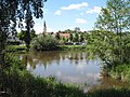
The rain at Cham

Beer gate
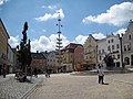
Marketplace

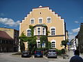
Town hall on the market square

Cordon House, now tourist information center


Neighboring communities
The city of Cham borders in the north on the communities Waffenbrunn and Willmering , in the northeast on Weiding and in the east on Runding and Chamerau . The municipality of Zandt is in the southeast, Traitsching in the south, Schorndorf in the southwest , the town of Roding in the west and the municipality of Pösing , which is part of the Stamsried administrative community, and the municipality of Pemfling in the northwest .
City structure
In addition to the core city, Cham includes 52 other districts :
| Districts of Cham | ||||||
|---|---|---|---|---|---|---|
| Altenmarkt | Altenstadt | Ammerlingshof | Brueckl | Well | ||
| Chameregg | Chammünster | Eichberg | Ellersdorf | Gredlmühle | ||
| Gutmaning | Haderstadl | Haidhäuser | Haidmühle | Hanzing | ||
| Hilm | court | Yards | Janahof | Kammerdorf | ||
| Katzbach | Katzberg | Kühberg | Kothmaissling | Laichstätt | ||
| Lamberg | hole | Loibling | Michelsdorf | Neumühle | ||
| Nunsting | Oberhaid | Ponwood mill | Quadfeldmühle | Ried on the stake | ||
| Ried am Sand | Cracking | Chess village | Scharlau | Schlammering | ||
| Schlondorf | Fairytale | Selling | Sick | Stadl | ||
| Bagging | Thierlstein | Untertraubbach | Vilzing | Wackerling | ||
| Windischbergerdorf | Wulfing | |||||
There are 14 districts in the municipality : Altenmarkt, Cham, Chameregg, Chammünster, Gutmaning, Haderstadl , Hof, Katzberg, Loibling, Rhanwalting , Schachendorf, Thierlstein, Vilzing and Windischbergerdorf. The Haderstadl district is shared with the community of Chamerau , the Rhanwalting district with the communities of Pemfling and Waffenbrunn .

history
Origin of name
The castle and town name Cham or Camma is of Celtic origin and means "on the curve" or "curvature" (cf. Irish cam 'bent, bent; insincere; wrong', Scottish Gaelic cam 'bent, bent; crooked, crooked ; one-eyed ', Manx cam ' bent, bent, twisted; misshapen; insidious ; crooked, crooked '< old Irish camm ' bent, bent, twisted, twisted '< ancient Celtic * kambos ). The Czech name of the city, Kouba , is also derived from the Celtic word . The winding river Chamb flows into the rain near the Altenstadt district of Cham . Therefore it is probably the Celtic namesake for the later royal castle Camma and the first settlement "on the rainbow". Later, the name Cham was set to “ Kamm ” in folk etymology ( Old High German kamb (o) , Middle High German kamp ), which is why the city's coat of arms also contains a comb.
middle Ages
Citizens' hospital from 1300, rebuilt in 1878

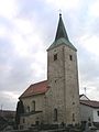
Today's parish church of the Assumption in Chammünster


The later Mark Camma was at the time of the Agilolfinger (6th to 8th century) ducal country. In 788 it became the king's country and belonged to the Bavarian northern district . In the year 748, Benedictine monks from the Regensburg monastery Sankt Emmeram in Chammünster , a current district of Cham, founded a cella (monastic settlement). As the so-called original parish (with the later Marienmünster), it became a starting point for the settlement and Christianization of the Upper Bavarian Forest and the Central Bohemian Forest . During the reign of the Liudolfinger (Ottonen), a border security organization was set up around 976 with the Camma Castle built on the royal land and other fortified castles, in which the later town of Cham (Camma) developed along with other places .
To the created in the 10th century, in 1055 for the first time mentioned Mark Camma (Bohemian Mark) with the castle Camma (Cham) who had Diepoldsberg Inger-Rapotonen , viscount of Nordgau and Marquis of Cham and Vohburg also Rohrau Castle and the rule Rohrau (Lower Austria) in Bruck an der Leitha. In 1204 after the extinction of their male line, the margraviate of Camma fell to the Wittelsbach family . In 1255 the Mark Camma came with the division of Bavaria to Lower Bavaria , where it remained until the years 1708–1714.
The place Cham was first mentioned as a city in 976 as Civitas Camma . At that time it was located on the ridge near the village of Altenstadt and was subject to the imperial castle Camma , which secured the trade route to Bohemia . Around the year 1000 Cham got its own mint, which minted the so-called Chamer Denarius.
In the 12th and 13th centuries, the city was moved to its current location. The first news about a Christian church comes from the year 1210, when Duke Ludwig der Kelheimer from the House of Wittelsbach gave an ecclesia in novo foro chambe , a church on the new market of Cham, to the German Order in Regensburg .
During the Hussite Wars in the 15th century, the citizens of Cham went through hard times. In 1429 an army group of the Hussites , who had conquered the town of Prachatice ( Prachatice ) in South Bohemia in 1420 and brutally raged against the population, came from Goldenkron, where they had burned down the Zlatá Koruna monastery in 1429 . At Satzdorf, at the gates of Cham, an army of knights of the Teutonic Order succeeded in defeating the Hussites on September 29, 1429. Heinrich Notthracht von Wernberg the Rich, at Runding Castle near Cham, contributed significantly to this victory. Another defeat of the Hussites in the nearby battle near Hiltersried on September 21, 1433 prevented their advance into Regensburg and Lower Bavaria .
In 1489 nobles in the Bavarian Forest founded the Löwlerbund , a noble society of the 15th century, which was directed against the Bavarian Duke Albrecht IV. (Bavaria) and his claims regarding financial benefits for his armed conflicts. This union met in a building on the market square of the city of Cham, which later became the Gasthof Zur Krone .
See also:
- Chameregg castle ruins
- Kammerdorf tower hill
- Katzberg Castle
- Lamberg tower hill
- Püdensdorf Castle
- Burgstall Schwedenschanze (Cham)
Modern times


From 1555 to around 1628, Cham was Protestant-Lutheran after the Augsburg Imperial and Religious Peace , which Ottheinrich of the Palatinate from the House of Wittelsbach had joined, and after three generations became Roman Catholic again during the recatholicization in Bavaria. During the Thirty Years' War (1618–1648), "the small fortress Cham" on the military road from Bohemia to southern Germany was occupied five times by changing mercenary armies and their commanders, and they were forced to pay and billet. During the Bavarian Diversion in the War of Spanish Succession under Elector Max II. Emanuel , the city of Cham also came to the Roman-German Emperor Joseph I (1678–1711) after his failed plans to raise the rank in 1703 . He enfeoffed Elector Johann Wilhelm with the Upper Palatinate and the County of Cham until the newly acquired area fell back to Bavaria after the peace treaty in 1715. The last uprising against this occupation was put down on January 16, 1706. In 1742, during the War of the Austrian Succession (1740–1748) under Franz Freiherr von der Trenck , the Pandurs conquered the city, which they sacked for nine days and finally set on fire on September 9, 1742 before moving on. The city center with its historical buildings was rebuilt.
In 1861, Cham received a railway connection in the course of industrialization . A phase of relative prosperity followed, as Cham was one of the most important timber handling centers in southern Germany. Here the wood that had drifted out of the Bavarian Forest on the rain was loaded onto the train. With the opening of the railway line from Deggendorf to Bayerisch Eisenstein in the Künischen Mountains in 1877, the importance of the town of Cham as a timber handling point declined.
Towards the end of the Second World War (1939-1945) 63 people were killed and 46 injured in an air raid on the night of April 17-18, 1945 when 90 Lancaster and 11 Mosquito of No. 5 Bomber Group of the Royal Air Force attacked the railway facilities of Cham. On March 1, 28 people were killed and over 70 injured in a low-flying attack on a train with refugees from the Protectorate of Bohemia and Moravia , the Sudetengau and eastern Germany stopped in Altenschwand . On April 23, 1945 Cham was captured by the 11th US Armored Division. Cham was then released for looting for three days. A prisoner-of-war camp for 20,000 people was set up in the Janahof district. Coming from Regensburg , American troops occupied the city of Cham, the Regental and Bohemia as far as the line from Karlsbad, Pilsen and Budweis at the end of May 1945. In October 1945 they surrendered the territory they had broadly occupied in western and southern Bohemia to Russian-Soviet troop units. In the border area with Lower Bavaria and the Upper Palatinate, the Iron Curtain border security zone existed until 1993 with a visa requirement and strict controls by the Czechoslovak Socialist Republic . Due to numerous expellees from Silesia and the Sudetenland who settled in Cham, the city's population increased from 5,860 to over 10,000 after the end of the war. The district of Michelsdorf was mainly settled by Belarusian emigrants in the post-war period.
On May 25, 2009, the city and the district of Cham received the title “ Place of Diversity ” awarded by the federal government and expanded new sources of income through medium-sized businesses and promotion of tourism.
Incorporations
In 1946, part of the then dissolved Katzberg community was incorporated into the city of Cham. As part of the regional reform in Bavaria , the previously independent municipalities of Altenmarkt, Loibling and the rest of the former municipality of Katzberg, Thierlstein and parts of the municipalities of Penting and Rhanwalting were incorporated into the city of Cham on January 1, 1972. On May 1, 1978, the communities Chammünster (with the 1946 incorporated communities Chameregg, Gutmaning and Hof and the 1972 incorporated Schachendorf, Vilzing and Haderstadl) and Windischbergerdorf and parts of Willmering were added.
Population development
Between 1988 and 2018, Cham grew from 16,641 to 16,907 by 266 inhabitants or around 1.6%. In 2002 the city had a peak of 17,366 inhabitants. On September 30, 2019, Cham had 16,990 inhabitants.
Religious communities
Christianity
Catholic Church


There are seven Catholic parishes and pastoral care units in Cham , which are assigned to the Deanery Cham in the Diocese of Regensburg :
In the core town of Cham, there are the two parishes of St. Jakob (Cham-Mitte and Cham-Ost) with the branch of St. Laurentius in the Vilzing district and St. Josef (Cham-West) with the subsidiary community of Katzberg, as well as the Catholic parishes looked after by the Redemptorist monastery Cham Hospital chaplaincy . There are also the parishes of the Assumption of Mary in Chammünster, St. Martin in Untertraubbach and St. Michael in Windischbergerdorf. The parishes of St. Josef in Cham-West and St. Martin in the Untertraubbach district together form a pastoral care unit.
The Redemptorist monastery Cham with its retreat house forms an important spiritual center of the city and with the monastery church Maria Hilf also includes its own monastery community.
Evangelical Church and other Christian communities
In addition, there is an Evangelical Lutheran parish in Cham (Deanery District Cham), a Baptist parish that is assigned to the Federation of Evangelical Free Churches in Germany , and a congregation of the New Apostolic Church ( parish Nuremberg-Ost).
Other denominations
There is also an Islamic religious community in Cham . There is also a Buddhist denomination and followers of Falun Gong . The Kingdom Hall of Jehovah's Witnesses is located in the Michelsdorf district .
Politics and administration
City council
The Cham City Council consists of 24 members. In addition to the political parties, its composition is traditionally strongly influenced by numerous voter communities and district lists. The local elections on March 16, 2014 resulted in the following distribution of votes and seats with a turnout of 57.8 percent (figures compared to the local election of March 2, 2008):
| Parties and constituencies | 2014 | 2008 | ||
|---|---|---|---|---|
| % | Seats | % | Seats | |
| Christian Social Union in Bavaria (CSU) | 18.9 | 5 | 20.7 | 5 |
| Social Democratic Party of Germany (SPD) | 7.3 | 2 | 6.7 | 1 |
| Alliance 90 / The Greens (GREENS) | 3.8 | 1 | 3.8 | 1 |
| Free voters (FW) | 16.1 | 4th | 16.2 | 4th |
| Christian Voting Community Chammünster (CWC) | 9.4 | 2 | 9.8 | 3 |
| Christian voter community Windischbergerdorf (CWW) | 9.3 | 2 | 8.3 | 2 |
| Altenmarkt / Michelsdorf Voting Association (WAM) | 6.1 | 1 | 7.0 | 2 |
| Loibling-Katzbach / Cham-West (GLK) | 6.7 | 2 | 7.0 | 2 |
| Voting Community Vilzing / Schachendorf (WVS) | 6.0 | 2 | 6.2 | 1 |
| Katzberger List (KL) | 5.3 | 1 | 5.3 | 1 |
| Voting Community Thierlstein (WT) | 5.5 | 1 | 4.9 | 1 |
| Janahofer List (JL) | 3.9 | 1 | 4.0 | 1 |
| Ecological Democratic Party (ÖDP) | 1.8 | 0 | - | - |
| total | 100 | 24 | 100 | 24 |
| voter turnout | 57.8% | 66.3% | ||
First mayor since 1874
| Surname | from | to |
|---|---|---|
| Nikolaus Brantl | October 1, 1874 | March 31, 1904 |
| Josef Drexel | April 1, 1904 | March 31, 1910 |
| Michael Heilingbrunner | April 1, 1910 | June 14, 1919 |
| Josef Vogl | June 15, 1919 | March 23, 1925 |
| Josef Ferstl (substitute) | March 24, 1925 | May 31, 1925 |
| Hans Brendel | June 1, 1925 | April 30, 1935 |
| Rudolf Brunner | May 1, 1935 | May 1, 1945 |
| Simon Tröger (acting) | May 19, 1942 | September 21, 1943 |
| Hans Rappert (acting) | September 21, 1943 | April 25, 1945 |
| Ernst Stockinger | April 25, 1945 | July 3, 1945 |
| Wolfgang Schmidbauer | July 3, 1945 | March 31, 1951 |
| Max Winter (substitute) | April 1, 1951 | July 15, 1951 |
| Ruprecht Gebhardt | July 16, 1951 | April 30, 1956 |
| Michael Zimmermann (SPD) | May 1, 1956 | April 30, 1984 |
| Leo Hackenspiel (FW) | May 1, 1984 | April 30, 2008 |
| Karin Bucher (FW) | May 1, 2008 | April 30, 2020 |
| Martin Stoiber (CSU) | 1st May 2020 | today |
Martin Stoiber (Christian Social Union) has been First Mayor of Cham since May 1, 2020 .
coat of arms
|
|
Blazon : "Under the shield head with the Bavarian diamonds , covered with two obliquely crossed silver swords with golden handles, in red between two silver pinnacle towers a crenellated wall , which is covered with a red shield , inside a silver comb." |
| Founding of the coat of arms: In its historical development, the city's coat of arms connects the coat of arms of a two- tower castle with a shield and the name-indicating crest, derived from seals from the 13th and 14th centuries , with the upper part of the shield awarded in 1809 by King Maximilian I Joseph for war merit the white and blue diamonds - a coat of arms inherited from the Counts von Bogen (noble family) - with the two crossed swords. The two crenellated towers and the connecting crenellated wall are symbols of the city's former status as a fortress with walls. The name-meaning comb for the name of the city is said to have been used since the Middle Ages. Since 1398 there have been colored images of the coat of arms, which show the crest, silver or gold in red, but almost always without castle walls. In the 19th century, the background color of the shield was mostly black instead of red. |
Town twinning
Cham maintains the following city partnerships:
- Municipality of Cham ZG (since 1981)
- District town of Klattau (since 1993)
- Zele municipality ( East Flanders Province ) (since 2009)
There are partnerships with the municipality of Alphen-Chaam (South Holland).
Since 2000, Cham has been the administrative headquarters of the cross-border action group Künisches Gebirge e. V.
Culture and sights
Castle chapel on the Katzberg

Interior view of the parish church of St. Jakob


Buildings and places
- Beer gate, 14th century, with round towers
- Historic town hall, in the 14./15. Built in the 18th century, modified and expanded several times. In 1875 it received a neo-Gothic extension to the east. The east wing with bay windows and belfry and the west wing with stepped gable and bay window are connected by a small structure with a passage.
- Straubing Tower, 14th century
- Watchtower of the inner city wall made of quarry stone, which was preserved from the medieval city fortifications. On its gable roof there is a stork's nest, which is a nesting place for a white stork colony every year .
- Parish church of St. Jakob , originally from the 13th century, changed several times, with stucco and frescoes around 1750, furnishings predominantly neo-baroque
- Castle chapel on the Katzberg
- Marienmünster in the Chammünster district
- Pilgrimage church of St. Walburga on the Lamberg near Chammünster
- Chameregg castle ruins
- Maria Hilf der Redemptorist monastery church , built in 1908 as a neo-Romanesque brick building
- Franciscan church from the 17th century, modified in 1866
- Hospital Church of the Holy Spirit from 1514, with Rococo furnishings
- Citizens Hospital
- Parish Church of St. Joseph
- Church of the Redeemer
- Pilgrimage Church of Our Lady of the Snow Schönferchen
- Streicherröhren pilgrimage chapel (shrub tubes) near Wulfing
- Grassl Tower
- Marketplace
- Stone market
- Hospital place
- Luitpold Tower on the Luitpoldhöhe in the Katzberg district
Art and museums
Museum track

- Municipal gallery with changing art exhibitions and municipal local history collection with the permanent exhibition Prehistory of the town of Cham and the surrounding area in the Cordon House, a Renaissance building from the 16th century
- Private gallery insights with changing art exhibitions by regional artists
- Art studio with sales exhibition of works by the workshops for the disabled in Upper Palatinate
- Museum Spur , painting, contemporary art, sculptures and works on paper by the artist group SPUR (1958–1965) in the former poor house (originally 16th century)
- Sacred art in the St. Anna Chapel in the Chammünster district
- Culture house Cham ( cha13 )
- Radio Museum Cham
Parks
In the course of the small state horticultural show “Nature in the City of Cham” in 2001, the city's green spaces were renewed and partly newly laid out. The city park by the Redemptorist monastery , which is only a few minutes' walk from the center, forms the green lung of the city. To the south-east of the center is the Quadfeldmühle, a large green area that also invites you to do sports. You will also find promenades integrated into nature, especially on the Regenufer.
graveyards
- In the Jewish cemetery between Cham and Windischbergerdorf , graves with memorial stones commemorate four victims of fascism . Until 1938, there was an Israelite religious community of merchants and business owners in Cham .
- In the municipal cemetery, a memorial commemorates concentration camp victims from the subcamps of the Dachau and Flossenbürg concentration camps , who were buried here before they were transferred to the local cemeteries.
Sports
Handball
The 1st team plays in the Landesliga Nord. The games take place in the hall of the Joseph-von-Fraunhofer-Gymnasium in Cham.
Soccer
The ASV Cham and DJK Vilzing play in the Bavarian League , the fifth-highest division in German football. The DJK Vilzing stadium has been known as the " Manfred Zollner Stadium" since September 23, 2005 .
The best-known player of the two clubs is the Vilzing-born Bundesliga professional Christoph Janker from Hertha BSC , who played for both teams in the youth.
Furthermore, FC Chammünster also has a football department.
shoot
The air pistol team of the Reichsburgschützen Siechen Altenstadt e. V. shoots in the fourth year in the Bayernliga Nord Ost.
Ice stock
The women's team of 1. FC Katzbach is shooting in the Bundesliga in its second year.
Regular events
- New year's reception of the city of Cham and the telecommunications battalion (FmBtl) 4 in the main hall of the town hall in early January
- Spring festival at the Volksfestplatz (exhibition center) Cham in May
- Fire nozzle shooting of the United Shooting Society (VSG) Cham e. V. at the Cham shooting range in May
- Old town festival on the Cham market square on the second weekend in July
- Folk festival at the Volksfestplatz (exhibition center) Cham at the end of July or beginning of August
- Chamlandschau, the largest fair in the region, at the Volksfestplatz (exhibition center) Cham in September
- Christmas market on the Cham square on the first three Advent weekends at the end of November or in December
Carillon in the town hall tower
- The Marseillaise , the French national anthem dedicated to the son of a citizen of Cham and later Marshal of France , Nikolaus Graf Luckner (1722–1794), and the Bavarian hymn at 5:55 pm are played daily at 12:05 p.m. from the town hall tower on the market square .
Economy and Infrastructure
Function as a regional center
The city of Cham is the central business location of the Upper Bavarian Forest region and functions as a regional center . As an economic center with modern industrial areas on the outskirts, which are important beyond the borders of the district , Cham is characterized by a large variety of industries. Around 600 small and medium-sized companies and some larger companies are based in the district town. Zollner Elektronik AG , Siemens AG Cham, Müller Präzision GmbH, Kappenberger + Braun and the Frey Handelsgruppe are known beyond the region .
armed forces
Cham has been the Bundeswehr base since 1959 . In the Nordgaukaserne in the past were units of the hunter or Panzergrenadierbrigade 11 such. B. the Panzer Grenadier Battalion 113 housed. By the end of 2014, it was the site of the Signal Battalion 4 of the Armored Brigade 12 .
traffic
Trunk roads
In Cham, the three federal highways 85 ( Amberg - Schwandorf - Passau ), 22 ( Bayreuth - Weiden - Oberviechtach - Cham) and 20 ( Straubing - Furth im Wald ) cross. The closest motorways are the A 3 near Straubing (30 km away) and the A 93 near Schwandorf (45 km away).
Railway lines
Cham is located on the Schwandorf – Furth railway line in the forest . At the Cham (Upper Palatinate) train station, the two branch lines to Waldmünchen and Lam . The main line is operated by the Regentalbahn under the name Oberpfalzbahn on behalf of Deutsche Bahn AG every hour, the secondary lines every two hours.
In addition, there are seven daily Alex train connections between the metropolises of Munich and Prague and two regional express connections operated by Deutsche Bahn AG between Nuremberg and Furth im Wald with a stop in Cham.
Local transport
The city of Cham has two city bus routes. City bus line 1 runs within the city center and Janahof, line 2 connects the city center with other parts of the city. Local public transport (rail transport, city and regional bus routes ) is linked to the tariff system of the Cham district traffic community.
Gliding
Cham glider airfield is located about one kilometer south of the city center at 49 ° 12 ′ 40 ″ N, 12 ° 39 ′ 36 ″ E.
education and Science
- Primary school Cham
- Johann Brunner Middle School Cham
- Marist Realschule Cham (formerly Marist School Brothers , since 2006 School Foundation of the Diocese of Regensburg )
- Gerhardinger Realschule Cham (formerly poor school sisters of Our Lady , since 2009 school foundation of the Diocese of Regensburg )
- Joseph-von-Fraunhofer-Gymnasium Cham
- Robert Schuman Gymnasium Cham
- Technology campus for research, development and teaching in the field of mechatronic systems at Deggendorf University
- Werner von Siemens School - State Vocational School Cham
- Technical college (FOS) and vocational college (BOS) Cham
- School at the rainbow (special educational support center Cham - support focus learning )
- St. Gunther Cham educational facility (support center with a focus on intellectual development )
- KUNSTbeTRIEB - Cham art school
media
- Bayerwald-Echo, edition: 16,228 (Monday to Saturday, 2007), regional edition of the Mittelbayerische Zeitung published in Regensburg
- Chamer Zeitung, circulation: 10,685 (Monday to Saturday, 2007), regional edition of the Straubinger Tagblatt / Landshuter Zeitung
- Radio Charivari , private radio broadcaster for the Eastern Bavaria region, frequencies for the Cham district: 92.7, 95.7, 102.6 and 105.5 MHz
- TVA , stands for TV Aktuell, a private regional television broadcaster for the eastern Bavarian districts of Regensburg, Straubing-Bogen, Kelheim and Cham
Personalities
Honorary citizen
- Max Fischer , State Secretary a. D. (1967), † 2015
- Johann Posel, civil engineer (1972)
- Friedrich Hutter , Director of Studies (1985), † 1993
- Michael Zimmermann, Former Mayor (1994), † 1999
- Adalbert Frey , Kaufmann (1997), † 2006
- Anton Kuchenreuter , businessman and master gunsmith (2000), † 2009
- Gerhard Schmidt, artist, Nazi contemporary witness and Green politician (2000), † 2007
- Dean Gerhard Huf (2005), † 2014
- Spiritual Councilor Franz Xaver Hebauer, Pastor i. R. (2006), † 2008
- Leo Hackenspiel, Former Mayor (2009)
sons and daughters of the town

- Nikolaus Graf Luckner (1722–1794), Marshal of France to whom the Marseillaise was dedicated; colorful Luckner figures serve as advertising media for downtown Cham
- Joseph Rudolf Schuegraf (1790–1861), historian and dialect researcher; in Cham a street is named after him
- Franz Xaver von Reber (1834–1919), art historian, professor and director of the Bavarian State Gallery in Munich
- Josef Witzlsperger (1838–1907), politician, member of the Reichstag and Landtag ( German Center Party )
- Hans Eder (1880–1966), politician, member of the Reichstag and Landtag ( Bavarian Farmers' Union , later CSU )
- Georg Achtelstetter (1883–1973), painter and writer
- Karl Stern (1906–1975), professor of neurology and psychiatry , author (including his autobiography Die Feuerwolke , Salzburg 1954, original English The Pillar of Fire , New York 1951); in Cham a street is named after him
- Karl Bosl (1908–1993), historian, professor of Bavarian national history at the University of Munich
- Julie Schmitt (1913–2002), gymnast and Olympic champion
- Fritz Zängl (1914–1942), born in what is now the Katzbach district, skier and NCO
- Adalbert Frey (1922–2006), entrepreneur and founder of the department store chain named after him
- Ernie Stautner (1925-2006), American football coach and player
- Gerhard Frey (1933–2013), publisher , founder and former federal chairman of the right-wing extremist German People's Union (DVU) , brother of Adalbert Frey
- Max Zierl (* 1934), senior director of studies a. D., former state chairman of the Bavarian Party (BP)
- Edgar Schiedermeier (* 1936), politician
- Gerhard Hösl (* 1939), lawyer, theologian and mediator
- Günther Lommer (* 1946), sports functionary and Cham local politician
- Wolfgang Gedeon (* 1947) doctor, author and politician
- Klaus Hofbauer (* 1947), born in what is now the Kothmaißling district, politician, Member of the Bundestag
- Reinhard Höpfl (* 1947), physicist
- Justin Hoffmann (* 1955), curator, head of the Kunstverein Wolfsburg
- Rene Pfeilschifter (* 1971), ancient historian
- Sonja Pfeilschifter (* 1971), marksman and seven-time world champion
- Daniel Stieglitz (* 1980), film director, screenwriter and illustrator
- Christoph Janker (* 1985), soccer player
- Stephan Plecher (* 1990), jazz musician
- Korbinian Burger (* 1995), soccer player
Others
Others
Prehistoric site
- Cham is an eponymous site of the early Neolithic Cham culture .
Location of film productions
- In 1959, director Bernhard Wicki shot the anti-war film Die Brücke in Cham . The filming locations were the old Florian-Geyer-Brücke over the Regen , which was demolished in 1991 and replaced by a new bridge in 1995, the city center and the former site of the Joseph-von-Fraunhofer-Gymnasium .
- In 2003 the thriller Happy End - Every story needs an end was filmed in Cham by the two Cham filmmakers Daniel Stieglitz (director) and Martin Tischner (production). To the annoyance of "Heimatguckern", the film contains mostly interior shots
- Not to forget: "De Überbliema or Ois stays better" from 2015.
- In 2017, the drama crime series "The Disappearance" was shot
Chamer means of payment
In the Middle Ages, the so-called Chamer Denarius was minted in Cham (see above).
In 1923 Cham issued local emergency banknotes with values between 500,000 and 500 billion marks. There were also four denominations that were denominated in Goldmark . All of these notes, like the Kötztinger emergency money, were produced by the J [osef] Wein book and commercial printer.
literature
- Karl Bosl : Cham. The history of the city and the surrounding area in 1200 years, 1989
- Johann Brunner, preparatory teacher, drawings by G. Achtelstetter, Neukirchen: History of the city of Cham , Pankraz publishing house, Baumeister's widow, Cham 1919
- Stephan Haering : The Mark Cham. On the lordly organization of a border region of the empire in the high Middle Ages, in: Contributions to the history in the district of Cham 11 (1994), pages 5–22
- Johanna von Herzogenberg : Between the Danube and the Vltava - Bavarian Forest and Bohemian Forest, Cham page 25,53,54; Chamb (river) pages 44,53,54; Chammünster page 33, Prestel-Verlag Munich 1968
- Gerhard Köbler : Historical lexicon of the German countries. The German territories from the Middle Ages to the present. 7th, completely revised edition. CH Beck, Munich 2007, ISBN 978-3-406-54986-1 , p. 106 (Cham (Mark, Marggrafen)).
- Jos. Lukas, cooperator in Cham: History of the town and parish of Cham , Cham 1862
- Golo Mann : Wallenstein - His life, 2nd edition 1971, S. Fischer Verlag GmbH Frankfurt am Main, text passage on Cham and Furth in the forest, pages 993 to 995; ISBN 3-10-047903-3
- Hans Muggenthaler / Franz Xaver Gsellhofer: Our Cham - a concise presentation of the history of the city of Cham from its beginnings to the present , Cham 1967
- Otto Wolf: History of Cham - Volume 1. Festgabe for the 1100th anniversary of the community of Cham , Cham 1958
Web links
Individual evidence
- ↑ "Data 2" sheet, Statistical Report A1200C 202041 Population of the municipalities, districts and administrative districts 1st quarter 2020 (population based on the 2011 census) ( help ).
- ↑ Employees. City of Cham, accessed on June 5, 2020 .
- ↑ Janine Fries-Knoblach, Heiko Steuer, John Hines (eds.): The Baiuvarii and Thuringi: An Ethnographic Perspective . Boydell & Brewer , Woodbridge / San Marino 2014, ISBN 978-184-383-7 , pp. 48 .
- ↑ Wolfgang Pfeifer: Etymological Dictionary of German . 7th edition. Deutscher Taschenbuch Verlag , Munich 2004, ISBN 3-423-32511-9 , pp. 612 .
- ^ Heinrich Gottfried Gengler: Regesta and documents on the constitutional and legal history of German cities in the Middle Ages , Erlangen 1863, pp. 482–486 .
- ↑ https://books.google.de/books?id=UlBnAAAAcAAJ&pg=PA298&lpg=PA298&dq=%22grafschaft+cham%22+Johann+Wilhelm&source=bl&ots=SmNqU_umRw&sig=ACfU3U1FQagIqZha-D77Au-jdPUqdIWrUg&hl=de&sa=X&ved=2ahUKEwiJtfK-yurnAhURm1wKHV3AAlYQ6AEwBXoECAoQAQ# v = onepage & q =% 22grafschaft% 20cham% 22% 20Johann% 20Wilhelm & f = false
- ↑ German Vogelsang: THEY ARE COMING! The last days of the war in the Upper Palatinate 1945 , Amberg 2015, ISBN 978-3-95587-008-9 , p. 62.
- ↑ Belarusian emigration in Germany (1945–1950) ( Memento from December 30, 2015 in the Internet Archive )
- ^ Wilhelm Volkert (ed.): Handbook of Bavarian offices, communities and courts 1799–1980 . C. H. Beck'sche Verlagsbuchhandlung, Munich 1983, ISBN 3-406-09669-7 , p. 439 .
- ^ Federal Statistical Office (ed.): Historical municipality directory for the Federal Republic of Germany. Name, border and key number changes in municipalities, counties and administrative districts from May 27, 1970 to December 31, 1982 . W. Kohlhammer GmbH, Stuttgart / Mainz 1983, ISBN 3-17-003263-1 , p. 644 .
- ↑ Entry on the coat of arms of Cham (Upper Palatinate) in the database of the House of Bavarian History , accessed on August 6, 2020 .
- ↑ Memorial sites for the victims of National Socialism. A documentation, volume 1. Federal Agency for Civic Education, Bonn 1995, ISBN 3-89331-208-0 , p. 121
- ^ City of Cham: honorary citizen. Retrieved February 8, 2020 .
- ↑ Cham banknotes

Arnschwang | Arrach | Bad Kötzting | Blaibach | Cham | Chamerau | Eschlkam | Falkenstein | Furth in the forest | Gleißenberg | Grafenwiesen | Hohenwarth | Lam | Lohberg | Michelsneukirchen | Miltach | Neukirchen near the Holy Blood | Pemfling | Pösing | Reichenbach | Rettenbach | Rimbach | Roding | Rötz | Rounding | Schönthal | Schorndorf | Stamsried | Tiefenbach | Traitsching | Treffelstein | Weapon Well | Forest | Walderbach | Waldmünchen | Weiding | Willmering | Zandt | Cell
Altenmarkt | Altenstadt | Ammerlingshof | Brückl | Brunn | Chameregg | Chammünster | Eichberg | Ellersdorf | Gredlmühle | Gutmaning | Haderstadl | Haidhäuser | Haidmühle | Hanzing | Hilm | Yard | Courtyards | Janahof | Kammerdorf | Katzbach | Katzberg | Kühberg | Kothmaißling | Laichstätt | Lamberg | Hole | Loibling | Michelsdorf | Neumühle | Nunsting | Oberhaid | Ponholzmühle | Quadfeldmühle | Ried am Pfahl | Ried am Sand | Cracking | Chess Village | Scharlau | Schlammering | Schlondorf | Schönferchen | Selling | Sick | Stadl | Bagging | Thierlstein | Untertraubbach | Vilzing | Wackerling | Windischbergerdorf | Wulfing