Heřmanov u Křižanova
| Heřmanov | ||||
|---|---|---|---|---|
|
||||
| Basic data | ||||
| State : |
|
|||
| Region : | Kraj Vysočina | |||
| District : | Žďár nad Sázavou | |||
| Area : | 539 ha | |||
| Geographic location : | 49 ° 23 ' N , 16 ° 11' E | |||
| Height: | 590 m nm | |||
| Residents : | 213 (Jan. 1, 2019) | |||
| Postal code : | 594 58 | |||
| License plate : | J | |||
| traffic | ||||
| Street: | Křižanov - Žďárec | |||
| structure | ||||
| Status: | local community | |||
| Districts: | 1 | |||
| administration | ||||
| Mayor : | Pavla Chadimová (as of 2020) | |||
| Address: | Heřmanov 35 594 58 Heřmanov |
|||
| Municipality number: | 595608 | |||
| Website : | www.hermanov.info | |||
Heřmanov (German Hermannschlag ) is a municipality in the Czech Republic . It is located 13 kilometers east of Velké Meziříčí and belongs to the Okres Žďár nad Sázavou .
geography
Heřmanov is located in the Křižanovská vrchovina ( Krischanauer Uplands) belonging to the Bohemian-Moravian Highlands on a ridge. The Panský rybník pond is located on the northeastern edge of the village. To the north rises the Křiblík (582 m), in the east the Strážnice (583 m), south of the Malý kamenný vrch (592 m) and in the south-west the Svatá hora (679 m).
Neighboring towns are Dolní Libochová in the north, Nová Ves and Radňoves in the north-east, Vidonín in the east, Milešín in the south-east, Ondrušky and Skřinářov in the south, Rohy and Ořechov in the south-west, Kadolec and Křižanov in the west and Bojanov and Kundratice in the north-west.
history
Hermanschlag was founded in the 13th century as part of the settlement of the forests of the Bohemian-Moravian Highlands by the Teutonic Knights and German colonists. The village, laid out around a wide village green, was first mentioned in a document in 1349 together with Březské and Březka as part of the Bochdalau estate belonging to Heinrich von Ossowa . The existence of a parish church has been documented since 1428. In 1437 the village belonged to the rule Náměšť nad Oslavou and was ascribed to Matthew von Schwanberg in the land table by the brothers Wenzel and Georg von Krawarn . Since then, the Hermannschlag estate has been an exclave of the Namiescht county, which was located within the Iglauer Kreis , but belonged to the Znojmo district . In 1752 the Counts of Haugwitz acquired the property.
In 1842 the village of Hermanschlag consisted of 37 houses in which 287 people lived. The parish, the church of St. Nicholas and the school , which belonged to the Great Meseritsch deanery, were under patronage . There was also a manorial brandy house, a yard and an inn in the village . Hermanschlag was the parish for Mileschin , Widonin , Radnowes , Neudorf , Mezyboř ( Meziboří ), Bojanow ( Bojanov ) and Kadoletz . Until the mid-19th century was Herman beat the connected with the Fideikommissgrafschaft Namiescht same landtäflichen Good submissive.
After the abolition of patrimonial formed Hermann shock / Hermašlak 1849 with the districts Milešín, Vidonín and Neudorf a municipality in the judicial district of the United Meziříčí and was assigned to the Jihlava district. From 1869 Hermannschlag belonged to the Groß Meseritsch district . In the 1870s the Czech name Heřmanice was created , which was changed to Heřmanov a little later . Vidonín broke up in 1875, Milešín in 1878 and Nová Ves in 1882 and formed their own communities. In the 1921 census, 308 people lived in the 46 houses in the village, 305 of them Czech. On January 1, 1931 Heinrich von Haugwitz renounced his patronage over Hermannschlag in exchange for a severance payment of 35,000 kroner. From 1948 the community Heřmanov belonged to the Okres Velká Bíteš. In the course of the territorial reform and the repeal of the Okres Velká Bíteš, the municipality came to the Okres Žďár nad Sázavou on July 1, 1960 .
The Catholic parish Heřmanov includes the localities Bojanov, Meziboří, Milešín, Nová Ves, Radňoves, Strážek and Vidonín.
Local division
No districts are shown for the municipality of Heřmanov.
Attractions
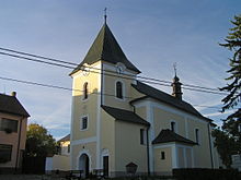
- Baroque parish church of St. Nikolaus, built in 1731 at the expense of the County of Namiescht and the Saar abbot Wenzel Weymluwa in place of a previous Gothic building from the 14th century
- Rectory, built in 1799
- Atonement Cross, on the road to Křižanov
- Heřmanov nature reserve , south of the village on the road to Skřinářov. The 1.89 hectare protected area, which has been in existence since October 19, 1979, is an important mineral site and so far the only place where the so-called Heřmanovské koule (German: Hermanover spheres or Hermanova spheres ), an egg-shaped aggregate of phlogopite core and anthophyllite crust, was found.
Individual evidence
- ↑ http://www.uir.cz/obec/595608/Hermanov
- ↑ Český statistický úřad - The population of the Czech municipalities as of January 1, 2019 (PDF; 7.4 MiB)
- ^ Gregor Wolny : The Margraviate of Moravia, presented topographically, statistically and historically . Volume III: Znojmo District, Brno 1837, p. 451
- ↑ Chytilův místopis ČSR, 2nd updated edition, 1929, p. 354 Heřmánky - Hiadeľ
- ↑ Mineral Atlas: Hermanover Kugel


