Horbach (Westerwald)
| coat of arms | Germany map | |
|---|---|---|

|
Coordinates: 50 ° 22 ' N , 7 ° 51' E |
|
| Basic data | ||
| State : | Rhineland-Palatinate | |
| County : | Westerwaldkreis | |
| Association municipality : | Montabaur | |
| Height : | 305 m above sea level NHN | |
| Area : | 3.93 km 2 | |
| Residents: | 658 (Dec. 31, 2019) | |
| Population density : | 167 inhabitants per km 2 | |
| Postal code : | 56412 | |
| Area code : | 06439 | |
| License plate : | WW | |
| Community key : | 07 1 43 034 | |
| Association administration address: | Konrad-Adenauer-Platz 8 56410 Montabaur |
|
| Website : | ||
| Local Mayor : | Christoph Büttner | |
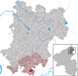
| Location of the local community Horbach in the Westerwaldkreis | ||
Horbach is a municipality in the Westerwaldkreis in Rhineland-Palatinate . It belongs to the Montabaur community .
Geographical location
The community is located in the Westerwald south of Montabaur in the Nassau Nature Park in the so-called Buchfinkenland .
history
Horbach was first mentioned in a document in 1486.
politics
Municipal council
The council in Horbach consists of twelve council members, who in the local elections on May 26, 2019 in a majority vote were elected, and the honorary mayor as chairman.
mayor
Christoph Büttner became the local mayor of Horbach in 2009. In the direct election on May 26, 2019, he was confirmed in office for a further five years with a share of 78.49% of the votes.
coat of arms
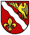
| Blazon : "In red a silver sloping bar, above a soaring, golden chaffinch with an outstretched right wing, below a heraldic lily " | |
| Justification of the coat of arms: The location of Horbach in the so-called Buchfinkenlandchen is represented by the chaffinch . The sloping wave symbolizes one of the source tributaries of the Daubach, which rises in Horbach. The heraldic lily , which the swamp lily served as a model, refers to the defining word of the place name: horo = swamp. The colors red and silver are the colors of the Electorate of Trier coat of arms. |
history
Horbach was first mentioned in a document around 1477. The place was part of the parish of Kirchähr with later seat in Gackenbach . The oldest survey from 1563 indicates 18 fire places in the place. In 1589, twelve families are recorded, with 176 inhabitants in 1786 and 246 in 1810.
The districts of the two desert areas of Nentzingen and Wilchenhausen have merged into the Horbach district. Nentzingen is located around 1200 meters north-north-west of Hübingen and 700 meters south-south-west of Horbach. The place, first mentioned in 1383, is given in 1563 with a size of two hearths. Presumably the village was abandoned during the Thirty Years War . Wilchenhausen was around 400 meters northwest of Horbach. It was first mentioned in 1408. In 1489 it was mentioned as having recently fallen.
Culture and sights
See list of cultural monuments in Horbach (Westerwald)
traffic
The next motorway junction is Montabaur on the A3 Cologne - Frankfurt , about nine kilometers away.
literature
- Hellmuth Gensicke : The parish Kirchähr . In: Nassauische Annalen , 77th Volume, 1966. pp. 328-337.
Web links
Individual evidence
- ↑ State Statistical Office of Rhineland-Palatinate - population status 2019, districts, communities, association communities ( help on this ).
- ^ The Regional Returning Officer Rhineland-Palatinate: Local elections 2019, city and municipal council elections
- ^ Annual review 2009. Christoph Büttner - New local mayor of Horbach. Verbandsgemeinde Montabaur, 2010, accessed on June 21, 2020 .
- ^ The Regional Returning Officer Rhineland-Palatinate: direct elections 2019. see Montabaur, Verbandsgemeinde, eleventh line of results. Retrieved June 21, 2020 .


