
Bad Endbach
| coat of arms | Germany map | |
|---|---|---|

|
Coordinates: 50 ° 45 ' N , 8 ° 30' E |
|
| Basic data | ||
| State : | Hesse | |
| Administrative region : | to water | |
| County : | Marburg-Biedenkopf | |
| Height : | 297 m above sea level NHN | |
| Area : | 39.84 km 2 | |
| Residents: | 7917 (Dec. 31, 2019) | |
| Population density : | 199 inhabitants per km 2 | |
| Postal code : | 35080 | |
| Primaries : | 02776, 06464 | |
| License plate : | MR, BID | |
| Community key : | 06 5 34 003 | |
| LOCODE : | DE BD6 | |
| Community structure: | 8 districts | |
| Address of the municipal administration: |
Herborner Str. 1 35080 Bad Endbach |
|
| Website : | ||
| Mayor : | Julian Schweitzer ( SPD ) | |
| Location of the municipality of Bad Endbach in the Marburg-Biedenkopf district | ||
  |
||

Bad Endbach is a municipality in the central Hessian district of Marburg-Biedenkopf , in the administrative district of Gießen . It is located 20 kilometers west of Marburg , 15 kilometers east of Dillenburg and 21 kilometers north of Wetzlar (both as the crow flies) in the so-called Hessian hinterland . The as Kneipp - spa recognized place with the Thermal ( Lahn-Dill-Bergland-Therme ) is embedded in the center of gladenbach uplands in the nature park Lahn-Dill-Bergland . It is characterized by the wooded hilly landscape, the gently undulating Bottenhorn plateau in the north (on average 500 m above sea level ) and the valley opening to the east on the upper reaches of the salt flats . To the south, the Salzbödetal merges into the ridge of the Zollbuche with the Endbacher Platte .
Bad Endbach has a large forest, 42.9% (1702 ha) of the municipality (3964 ha) is covered with forest .
In the community area, which was permanently settled relatively early (6th to 8th centuries), important trade and messenger routes ran until the late High Middle Ages , namely the formerly very important "Leipzig-Cologne long-distance trade route", called " Brabanter Strasse ", which ran through the Bottenhorn plateaus crossed and the " Westfalenweg " running south-north in the west . The high medieval "Marburg-Dillenburger / Herborner Amtsweg" (Botenweg), in the area of the upper Salzbödetal ( Weidenhausen and Bad Endbach municipality) also called "Obergerichtsweg", was even used until the construction of the new country road (1865), today's national road L 3050, in use.
In the middle of the 20th century, the Hinterland women 's costume worn in the municipality with the "Dell Mutsche" as headgear with the last wearer died out. The "Dell-Mutsche" was a variant within the common costume landscape of the former Blankenstein office , which was worn in the so-called "Blankensteiner Obergericht" (today the municipality of Bad Endbach).
In the municipality, Hinterländer Platt is spoken in the variant of the "Blankensteiner Obergericht", but with a decreasing tendency.
geography


Geographical location
The landscape in which Bad Endbach is located is spacious, part of the south-east slope of the Rhenish Slate Mountains and forms the transition to the red sandstone area of the West Hessian Basin . Bad Endbach is located at the junction of different natural areas of the Gladenbacher Bergland , the Bottenhorn plateaus , the Schelderwald and the Zollbuche (natural area) , in a varied low mountain range west of Marburg , east of Dillenburg and north of Wetzlar . The community is a member of the Lahn-Dill-Bergland Nature Park .
On a small scale, the northern municipal area is part of the southern roofing of the Bottenhorn plateaus (on average 500 m), a plateau that is part of the geologically ancient Angelburg (mountain) massif in the Schelderwald. That was a formerly much higher single elevation (clod elevation) from the Tertiary , which in the course of the earth's history up to today's max. Height of 609 m was removed. The Bottenhorn plateaus are one of the oldest land surfaces in the Rhenish Slate Mountains.
South of the upper reaches of the salt flats is the ridge named after a historic customs beech cross . The district of Günterod is located on this south-eastern ridge on the municipal boundary .
The Bottenhorn plateaus are both a source area and a watershed at the same time. In addition to many smaller watercourses, the larger brooks arise here (clockwise, starting in the west): Schelde (flows into the Dill ), Gansbach , Perf , Dautphe , Allna , Salzböde (flows into the Lahn ) and Siegbach (flows into the Aar / Dill ). They break up the ridges with their cones, peaks and valleys into individual settlement areas. Everywhere nature (forest) reaches close to the settlements and encloses the individual districts.
The mountain Hiemerk (357 m), in the southeast of the municipality between Wommelshausen -Hütte and Weidenhausen , lies like a bolt in the middle of the Salzbödetal and closes off the natural area Zollbuche with the "Upper Salzbödetal" to the east to the Lower Salzbödetal at the interface of three natural areas . Here in the Salzbödetal, east of the district of Hütte, just before the mountain Hiemerk (Hiemerich) lies the lowest point in the area at 268 m.
The municipal areas of Hartenrod, Endbach and the district of Hütte extend along the Salzböde brook, which rises in the Schlierbach district.
mountains
The highest elevations in the municipality are, starting clockwise in the west: Hirschhohl 502.4 m; Steiger 542.8 m; Würgeloh 563.9 m (highest point in the municipality); Schindeberg 553.2 m; Free mountain 528.1 m; Kreuz-Berg 532.8 m; Hils-Berg 525.9 m; Scheid 538.9 m (there is an elevated drinking water tank here); Pig's head 519.2 m; Ebersberg (in the center of the municipality) 507.8 m and south of the salt flats: Endbacher Platte 467.1 m; west of it without a name 487.7 m; Mell-Berg 472.1 m; Kissel Mountain 439.1 m; Schönscheid 490.2 m and the nameless summit, 250 m northeast of it, 498.0 m.
Altitude of the districts
The district of Hülshof is at 495 m, Bottenhorn at 485 m and Dernbach at 470 m (all three locations of the Bottenhorn plateaus); Günterod at 410 m (on the Zollbuche ridge), Schlierbach at 370 m, Wommelshausen at 350 m, Hartenrod at 335 m, Endbach at 300 m and Wommelshausen Hut at 285 m in the Salzbödetal. (Heights refer to the center of the village)
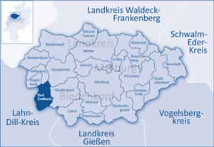
Neighboring communities
Neighboring communities of Bad Endbach are starting clockwise in the north: the communities Angelburg , Steffenberg and Dautphetal and in the east the city of Gladenbach . All of these communities and the city are, like Bad Endbach itself, in the Marburg-Biedenkopf district . The municipality of Bischoffen borders in the south and the municipality of Siegbach in the west . Both belong to the Lahn-Dill district .
Community structure
The municipality of Bad Endbach is divided into eight districts .
| District | description |
|---|---|
|
|
approx. 1150 inhabitants, first mentioned in 1253. Historical forms of name: 1253 Budehorn, 1304 Botinhorne, 1324 Buttinhorn, 1491 Bettehorn, 1502 Bottenhorn. Bottenhorn is the oldest town in this area. |
|
|
approx. 300 inhabitants. Historical forms of name: 1363 Therinbach, 1398 Derenbach, 1411 Dernbach. From 1350 to 1748 Dernbach was the seat of the noble family of the same name " von und zu Dernbach " in Neu-Dernbach Castle . |
|
|
approx. 2300 inhabitants, eponymous capital. First mentioned in 1261. Historical forms of name: 1261 Endebach, 1577 Ennebach |
|
|
approx. 1000 inhabitants, historical forms of name: 1294 Gunterode, 1343/47 Günterrode, 1416 Günterade, 1479 Gonterodde, 1502 Gunteroide, 1564 Günterode |
|
|
approx. 2350 inhabitants, largest district. First mentioned in 1311. Historical forms of name: 1311 Harprehenzrode, 1364 Harterode, 1380 Harprachterode, 1397 Hartenrade, 15th century Hirtprachterode, 1466 Hartenrode, 1502 Harteroide, 1630 Hartenroda. Hartenrod has had market rights since 1684 (four markets per year). |
|
|
approx. 20 residents who live on four farms, the smallest and highest located district (495 m), also in the district. First mentioned in 1284. Historical forms of name: 1284 Hulsbahc, 1304 Halespecher marca, 1304 Hulisbach, 1344 Hultzpach, 1354 Hulzbach, 1397 Holspach, 1630 Hulß Hoff. Until 1463, Hülshof belonged to the Altenberg monastery . |
|
|
approx. 400 inhabitants. First mentioned in 1318 as Slirbach (Slir-Lehm). The stream of the same name flows through the village. Historical forms of name: 1318 Slirbach, 1359 Sclirbach, 1448 Slierbach, 1630 Schlirbach. |
|
|
approx. 850 inhabitants. First mentioned in 1336 as a double place Womoldishusin superior et inferior (the village of Ober- and Nieder-Wommelshausen). Historical forms of name: 1340 Womulshusen, imprecise dating Wommeldishoffen, 1400 Waneboltshusen, 1536 Wumolzhusen, 1707 Womelshausen. The Romanesque chapel ( Old Church Wommelshausen ) was rebuilt as early as 1268 . Accordingly, the village already existed at that time.
The hut district belongs to Wommelshausen . Formerly district Wommelshausen, today 80 percent district Endbach. Hut is not identical to the submerged village of Nieder-Wommelshausen . The district emerged from a late medieval ironworks / forest smithy , called 1496, 1499. Historical forms of name: 1570 uf der Hutten, 1703 the hut. |
The municipality and its formation in the Middle Ages


The extent of the municipality is essentially determined by the Landheegen (see also Landwehr ), the "Inner" and the "Outer", which were created by the Hessian Landgraves 700 and 650 years ago, respectively. The area enclosed by the Heegen, within which the districts are still located today, formerly corresponded to the administrative district "Obergericht" of the Blankenstein (Gladenbach) office. It was congruent with the parish of Hartenrod. This administrative district has been preserved for over 650 years and today forms the large municipality of Bad Endbach.
The border in the northeast of the municipality of Bad Endbach is congruent with the eastern border of Bottenhorn, which is based on the route of the high medieval "Heerstraße" on the ridge between Bottenhorn and Holzhausen (Hünstein). The military road branched to the house of the Cologne-Leipzig trade route (also Brabant street called) and moved northward along the watershed between Perf and Dautphe , continue towards bagpipe .
From the district of Dernbach, the eastern border follows exactly the course of the " Innenheege " laid out between 1297 and 1307 under Landgrave Heinrich I , except for the southern section between the districts of Wommelshausen and Weidenhausen (from the Salzböde to the "Endbacher Platte"). . The Innenheege was also the border between the administrative districts of the upper court and lower court of the former office of Blankenstein and at the same time the border between the two parishes of Hartenrod and Gladenbach . Today it is the border between Gladenbach and Bad Endbach. It is also the dialect of the dialect (e.g. Hink / Huink for "honey", Emer / Äimer for "bucket", Läder / Lädder for ladder) and was a traditional costume border (Dellmutsche / Schneppekapp, see Hinterländer traditional costumes ).
The course of the north-west, the west and the south border is based on the route of the “ Außenheege ” built between 1359 and 1374 under Landgrave Heinrich II . It began in the north on the Kreuzberg (between Bottenhorn and Steinperf) and ran over the Aar / Salzböde watershed towards the Zollbuche . Günterod was then outside the Heege, in the county of Solms . The north and north-east boundaries of the Günterod district corresponded to the course of the external hedge. It was not until 1443 that Günterod, which had belonged to the Lords von und zu Dernbach from 1354 , became part of the Hessian community and was integrated into the Blankenstein High Court .
Since Günterod's incorporation, its western border, together with the western borders of the communities of Hartenrod and Schlierbach, formed the former state border between Hessen-Darmstadt and Nassau , and later the district border between the Dill district and the Biedenkopf district. Today it is the border between the new districts of Marburg-Biedenkopf and Lahn-Dill in the municipality.
geology

Geologically, the area belongs to the eastern part of the Rhenish Slate Mountains , to the so-called Hessian Synklinorium , which has the most complicated structure of the Rhenish Slate Mountains.
Three large geological structures, Dillmulde , Hörre-Zone and Lahnmulde , are separated from each other by far-reaching faults. The Hörre-Nordrand thrust delimits Dillmulde and Hörre from each other, the Weidbacher thrust the Hörre against the Lahnmulde. Over long periods of time, the Dill and Lahn basins on the one hand and Hörre on the other hand went through various sedimentation developments, which is documented in the facials' formation.
The rocks of the municipality come from the Devonian and Carboniferous . It is predominantly slate , sandstone , greywacke , limestone , claystone , silica slate and diabase (Hinterland green stone ). Mineral-containing thermal waters, which rose in the Middle and Upper Devonian, led to ore deposits in the crevices and crevices of the diabase and the carbonic Kulm schist (see mining and metallurgy in the Lahn-Dill area ). There are also an unusually large number of ores and mineral substances here: iron , copper , nickel , manganese , lead , silver , zinc , malachite and traces of: titanium , vanadium , cobalt , chromium and barite , limestone, diabase and slate .
The municipality of Bad Endbach is located in the strongly indented southwest flank of the Dillmulde, on the border with the Hörre . This transition zone is characterized by numerous thrusts and tectonic scales . The rocks of the Hörre as well as those of the Gießener blanket , which is further south near Wetzlar and Gießen, are of very different formation compared to those of the Dill and Lahn basins. A non-local development of the entire Hörre and the thrust as a tectonic blanket over several tens of kilometers on the Dill and Lahn basins is discussed.
Bad Endbach itself is located in the so-called Endbach Scale, consisting of slates means Devon , Devonian and volcanic rocks of the sub-Karbon (Deckdiabas) together with shales (Kulmtonschiefer) and graywackes (Kulmgrauwacken) consists. Rocks from the Lower Devonian occur in association with the Middle Devonian schists. Similar rocks at Günterod were interpreted as submarine slide masses from the Lahnmulde area. The districts of Hartenrod, Schlierbach, Hülshof and Bottenhorn are in the area of the Eiternhöll-Schuppe (Oberdevon, Unterkarbon in Kulm-Fazies), which are separated from the Endbacher Schuppe by a strip of diabase and Kulmton schist with the districts of Wommelshausen and Dernbach.
The slate mountains were leveled in the Tertiary . Today's river networks developed by cutting into the old turf. From this time old land surfaces have been preserved, especially at Bottenhorn ( Bottenhorn plateau ) and to the west of it, as well as at Holzhausen / Hünstein and Weidenhausen. They belong to the oldest generation of land surfaces in the Rhenish Slate Mountains.
Deposits and mining
Mining has a long tradition in the region and the municipality and is likely to go back to the early days. It can be assumed that Celtic and Germanic tribes already used the hematite (over 70% iron, e.g. in the quarry near Rachelshausen ) for their weapons production in this area in the narrow crevices of the cover diabase . Mining was practiced throughout the Middle Ages until the recent past.
The "Hüttner Hut" near Wommelshausen
Forest blacksmiths, who processed turf iron and others, bear witness to medieval iron ore processing in the upper Salzbödetal . a. the late medieval ironworks at Weidenhausen (Gladenbach) (location: Waldmühle ) and at the hut district of the municipality of Wommelshausen. In 1496 a forest smithy is mentioned in the district of Hütte, approx. 1.5 km southeast of the main town Wommelshausen, and in 1499 a “Schyluckemoller uss der moelen uff der schmytten”. (Location: Hüttner-Mühle , at the confluence of the Dernbach in the salt flats , evidenced by slag finds). The processed ores came from Wommelshausen, Endbach, Bottenhorn and Dernbach. The steelworks existed from around the middle of the 15th century to the end of the 16th / beginning of the 17th century. It is assumed that the work was abandoned because the price of bar iron fell rapidly at this time and also the local charcoal due to overuse the groves became scarce. To produce one ton of iron you needed four tons of charcoal, for which about eight times the amount of wood had to be charred. Around 8000 m² of well-stocked coppice had to be cleared for this. The rulers were forced to close smaller iron smelters and concentrate production in a few places, near large forests. The ore was brought to the wood.
As early as 1660, iron ore was transported from Wommelshausen to the Bieberhütte near Rodheim-Bieber in order to maintain the smelting operation. The Hüttner hut no longer existed at that time.
The hut district of the municipality of Wommelshausen emerged from the small settlement of ironworkers .
Eisenstein drives
When the Hüttner hut was closed, the residents of Bottenhorner had to bring ore to the Ludwig hut near Biedenkopf from 1668/1677 . A list from this time shows which municipality had to drive how much iron ore to Ludwigshütte “for cheap wages”: Bottenhorn 126 Maß, Günterod 102 Maß, Endbach 100 Maß, Hartenrod 91 Maß, Schlierbach 45 Maß and Wommelshausen 85 Maß. A trip to Eisenstein (there and back) with a wooden box van and driving cows or driving oxen as draft animals lasted longer than a day.
The log of a Möllerung (blast furnace filling) of the Ludwigshütte from 1849 leads, among other things, z. B. also six carts of iron stones from Dernbach.
Iron, copper, zinc, lead, nickel, barite
The following list illustrates the extent and importance of mining in today's municipal area. Only known ore mining sites are mentioned. Of the other numerous unnamed sites from the early and high Middle Ages today testify only devolved adit holes, pits and dumps and final syllables in place names such as -kaute or -griww = pit.
From 1674 to 1878 copper and lead ore were mined in the Grüner Baum mine in Hartenrod; From 1775 to 1830 iron, copper, nickel, zinc and malachite were excavated at the Eisenberg . From 1733, Hesse had five new mines built in the upper court of the Blankenstein office (today's municipal area), two of them in Hartenrod and one in Wommelshausen. From 1783 copper ore was mined from the Jakobsgrube and from 1800 to 1846 from the Hirschhohl and Holde Eintracht mines copper and zinc ore. During this time there was also a bronze foundry in Hartenrod.
In Günterod, Am Schönscheid was dug for copper and lead from 1775 and also for heavy spar in the 19th century. From 1977 to 1982 the Federal Institute for Geosciences and Raw Materials had exploration drillings carried out at Am Schönscheid for barite, copper and silver. The falling metal price prevented expansion.
Barite ( barite ) had been discovered as early as 1828 , but initially nothing could be done with it. It was not until 1884 that the Bismarck mine, north-west of Hartenrod , began to mine barite and copper. This mine remained in operation until 1957. The spar from the Koppe pit, located directly on the border (municipality of Wallenfels in the Schelderwald ), was also processed in the adjoining spar mill . The pit and mill were connected by a cable car from 1925 to 1943. The barite deposit in Hartenrod was one of the most important in Germany and at times gave up to 180 employees work and bread.
Iron, copper and nickel ore were mined in the Bottenhorn Mine Reconciliation in 1845; in 1858, Roteisenstein was mined at Kreuzberg and in 1870, a barite deposit was excavated, which was activated again in 1956 with the Barbara shaft . In two tunnels "am Brühl", at the western foot of the "Räschert", in the hut district, nickel ore and copper ore were mined from 1865/66 , but stopped again after a few years due to the low yield.

In Dernbach, iron ore mining goes back to the Middle Ages, for example from the pits in the Ruremark (Red Mark) district above the Hintermühle directly on the former Dernbach / Wommelshausen boundary, which were exploited until the second half of the 19th century. In the 1930s, attempts were made to resume mining here. The Elisabeth mine (east of Dernbach), which was put into operation in the middle of the 19th century, produced iron ore and barite. In the 1920s, the Germania shaft was sunk northeast of Dernbach , from which Spat was also extracted.
Wommelshausen also has a mining history that goes back far into the Middle Ages, as evidenced by the former Wommelshausen hut (15th / 16th century). The numerous field names with the ending -griww (pit) indicate this. Roteisenstein still appears in many places today. From 1654 iron ore mining was intensified again. In 1733 the landgrave had a new pit built here (location and name not known). Several former mining sites have been handed down orally. But only the Rainborn mine is known by name.
From an economic point of view, all deposits mentioned in the list are no longer worth mining today.
Diabase


When ore mining ended, the quarrying of diabase , especially the paleopicrit variety, has been an alternative to local livelihoods since the end of the 19th century. This diabase variety is known as the Hinterländer Grünstein . It mainly consists of the minerals olivine and augite . From the former small and medium-sized quarries in Günterod, Schlierbach and Wommelshausen you can still find the outcrops and the spoil heaps. The large quarries in Dernbach, Bottenhorn and Wommelshausen have left deep scars in the landscape and have changed it significantly in some areas.
Today only the large “Hahnkopf” quarry, which was opened in 1902, is still in operation. He is on two markings; the actual quarry in the Wommelshausen district and the administration with the crusher and the concrete mixing plants in the Hartenrod district. The Grenzbach Hülsbach separates the two parts of the company. The oldest part of the quarry site has meanwhile been filled with garbage, rubble and overburden.
Mineral and thermal water resources
The Lahn-Dill area and with it the area around Bad Endbach is located on the western edge of the European rift zone , a tectonic weak zone in the earth's crust. This zone begins in Europe at the mouth of the Rhone , continues via the Burgundian Gate , through the Upper Rhine Rift, the West Hessian Basin and northern Germany (Lüneburg, Gorleben) into the North Sea to the oil fields off Norway. It is part of the Mediterranean-Mjosen zone . A second arm stretches along the Rhine to its mouth. In Germany and the Netherlands, natural gas and oil have been or are being produced along these zones. Almost all of the major German mineral water resources (conveyor systems) can also be found in this area.
From the south, via Wiesbaden, Selters , Neuselters / Biskirchen, Löhnberg, a deep underground chloride water flow (deep water deposits) moves north towards Dillmulde , Hörre-Zone , Salzböde , Lahnmulde . It is not known where it ends.
Satellite images show significantly more recent geological fault zones / faults in the upper Salzbödetal, which are ideal for thermal and / or mineral water drilling. Due to the geothermal gradient ( geothermal depth ), i. H. An increase in temperature of 3 ° C per 100 m depth is to be expected at an average temperature of 7 ° C in the Endbach area at a depth of 1000 meters, a temperature of 37 ° C. This is the basis for the thermal water drilling in Bad Endbach, whose water has been used since 2009.
The salt flat , which rises in the municipality and on whose upper course the municipality is located, has its origin in the salt marshes north of Hartenrod in the municipality of Schlierbach.
climate
General
In terms of large climates, the Bad Endbach area belongs to the climate boundary region between southwest Germany, northwest Germany and western central Germany, with the maritime climate component of northwest Germany being somewhat predominant. In terms of landscape, Bad Endbach clearly belongs to the Westerwald climate, which is mainly expressed in the abundant rainfall of almost 890 mm (long-term annual mean). The municipality can be counted among the regions with high rainfall. It has a water balance surplus. On the other hand, persistent dryness quickly becomes noticeable in the thin crumb . Most of the precipitation falls in June / July and November / December.
Snowfall can be expected on 40 to 50 days. A closed snow cover is 60 days, in Hülshof and Bottenhorn up to 90 days. In Hartenrod there is therefore also a ski slope with a lift and floodlights . A challenging trail is regularly groomed on the Bottenhorn plateau in winter .
Mild winters and warm summers prevail. The following applies to the districts of Endbach, Hartenrod, Schlierbach and Wommelshausen including Hütte in the core area: The mean minimum temperature in January is given as around −1.2 ° C, with fluctuations between +3.6 ° C and −8.0 ° C can occur depending on the severity of winter. In April the mean temperature is +6.1 ° C, in July +15.0 ° C and the annual average +7.0 ° C. The mean annual fluctuation is +16.5 ° C. Different dates apply to the villages of Günterod, Dernbach, Hülshof and Bottenhorn. This can also be seen in the fruit and grain ripening in Hülshof and Bottenhorn approx. 10 to 14 days later compared to the lower-lying districts.
In the higher-lying districts of Bottenhorn, Hülshof, Dernbach, Günterod and Wommelshausen, uncomfortable humidity and persistent fog play practically no role compared to the somewhat more vulnerable districts in the Salzbödetal (Endbach, Hütte and Hartenrod). Winter cold air from the east hits them almost unhindered; however, its outflow is always guaranteed so that it cannot stagnate.
storm
On the evening of September 17, 2006, over 100 mm of rain fell in the municipality of Bad Endbach in just a few hours (long-term annual average: 890 mm), causing salt flats , Endebach and the other tributaries to rise over their banks. During this hitherto most severe storm (since 1826 in Schlierbach and Bottenhorn) in the history of the municipality, the cellars of the houses near the bank filled up within a few minutes.
The area around the Bad Endbacher Kurpark was hit worst. Here the water dammed up in front of the narrow passage under Herborner Straße. Within a few minutes, the tides rose to around 1.60 meters. The water masses destroyed the safety glass of the windows on the ground floor of the Kur- und Bürgerhaus and destroyed u. a. the archive and a restaurant.
The hurricane Kyrill uprooted or destroyed areally numerous Nadelbaumwaldungen on 18 and 19 January 2007, particularly in the private and community-owned forests on the Bottenhorner plateau. Beech forests were also heavily devastated, e. B. in the state forest east of the Dernbacher sports field.
history
prehistory
The prehistory of Bad Endbach starts with the oldest traces of human activity that have been found. In the upper Salzbödetal, the beginnings of human culture that we can recognize go back to the Stone Age . Strangely worked flint stones from the Neolithic era were found in the district of Hartenrod after 1920 , which were perhaps used as weapons (clubs, hand axes , stone knives and spearheads) or agricultural implements. Stone implements for hunting and agriculture were also found in other parts of the district, including flint stones weighing two kilograms that could have served as ploughshare.
Jade hatchet and double ax (amazon ax)
During excavation work for the aqueduct in Günterod, a stone ax (jade ax) made of jadeite was found , which is attributed to the Neolithic Age (5300 to 3000 BC). This ax is an extremely rare find for the local area and was certainly a prestige or cult symbol in the past. Jadeite occurs only in two places in Europe, several hundred kilometers away on Monte Viso and Monte Beigua in the western Alps.
In the district of Wommelshausen, an approximately nine centimeter long trapezoidal ax from the Neolithic was found in a field on the Äwwelt .
A big surprise and an important find for the local history was the old, broken stone half of a double ax made of diorite , a so-called Amazon ax - probably a status symbol with cultic significance. It was discovered during excavation work in 1973 in Wommelshausen in the new building area on the Gewenn (field name). This double ax from the early third millennium BC Chr. ( Neolithic , Beaker culture , megalithic , barrows ) is the most southerly Fund a decorated with grooves ax and the only copy in Hesse. An almost similar unbroken double-edged ax was found as an addition in a single grave in Wertle / Emmeln Krs. Meppen.
In Endbach in 1952 a pit with storage vessels from the La Tène period was cut on the road to Hartenrod (Debus nursery) .
However, these few individual finds do not necessarily suggest an early settlement. Due to its location in the southern roofing of the Bottenhorn plateaus and its geomorphology , the upper Salzbödetal was not unfriendly to settlement. The abundance of forests and water and the side valleys running from north to south with their sunny peripheral locations offered potential settlement areas sufficient protection against both the cold, wet west wind and the dry east wind. There were also ideal locations for living spaces on the plateau at Hülshof and Bottenhorn ( Bottenhorn plateaus ). There are still no concrete references to prehistoric or early historical settlement sites.
Early history
Around 500 BC The Lahn-Dill area and the Rothaargebirge were settled by Celts from the south (e.g. Dünsberg ) and southeast (e.g. Kirchain-Niedernwald and Amöneburg ) . The incentive was certainly the easily accessible ore deposits (iron and copper) with usable quality. This also created the first permanent living spaces during the late Hallstatt period . Numerous place, river and mountain names can be traced back to these settlers, for example the names with the endings -lar (Wetzlar, Weimar), -phe (Lasphe, Banfe), -a (Laisa, Eifa) or the Lahn and the Brooks Perf and Dautphe and the endings -merk and -merich in field names that stand for "mountain" or mountain slope.
In the decades before and after the birth of Christ, Elbe Germanic ethnic groups (Suebi?) Immigrated to Central Hesse from the northeast and east and settled here. At the same time the Romans tried to bring the area from the Rhine to the Elbe under their rule. Using the old long-distance routes, they penetrated the Central Hessian area and built military camps, e.g. B. near Niederweimar and Dorlar, and began to build a town near Waldgirmes (see Roman Forum Lahnau-Waldgirmes ), as recent excavations show. These facilities fell into disrepair after 9 AD, probably as a result of the catastrophic defeat of the Romans against the Teutons in the battle of the Teutoburg Forest.
It is no longer possible to determine exactly which ethnic group settled here up to the time of the Great Migration, most likely a Celtic-Germanic mixed population, which can be assigned to the Chatt tribe . During the migration period , the area does not seem to have been completely evacuated, large parts of the population stayed in the settlement chambers and thus preserved the linguistic continuity.
Proselytizing
The hinterland was not repopulated during the Franconian conquest from the 6th century, but only colonized by the king, the Gau - counts , monasteries and monasteries and Franconian nobles. The missionary work went hand in hand with this. The Franconian cent limits and Gau limits were set by which the church organization largely orientated itself during missionary work. Iro-Scottish wandering monks ( Iroschottische Mission ) had already done missionary work here since the beginning of the 7th century and founded the first bases and thus churches in the Central Hessian area (e.g. Amöneburg , Büraberg , Wetter , Schotten , Wüstung Hausen . Near Lich and Naunheim (Wetzlar) ). Boniface built on this iro-Scottish organization during his mission and reformed it according to the Roman model. The division and limits of the Roman church organization of that time have partially been preserved to this day. They can also be reconstructed in some places if one takes into account the old church responsibilities, such as parish districts (Urkirchen, Mutterkirchen, Taufkirchen, Sendkirchen), archdeaconate boundaries and diocese boundaries (between Mainz and Trier).
middle Ages
Many places in the Upper Salt Flats settlement area already existed in the 8th century. Today's ‑hausen places in the southern hinterland, such as Rachelshausen, Runzhausen, Römershausen, Erdhausen, Weidenhausen and Wommelshausen, are likely to have originated during the Frankish colonization , in the period from 650 to 950 AD. Endbach, Schlierbach and Hülshof (formerly Hülsbach) are to be set at the same time, while Eisemroth, Günterod and Hartenrod, as clearing settlements, belong to an expansion period towards the end of the first millennium. Bottenhorn is probably the oldest settlement in the community, while Dernbach can only be mentioned as a settlement with the construction of the castle in 1350. The early medieval settlement consisted of individual courtyards, courtyard groups, scattered settlements in the form of hamlets , as open, loose courtyards.
Settlements are only mentioned in documents if legal transactions have been made that are related to the place, such as B. donations to monasteries or churches, feudal or judicial rights acquired, residents appeared as witnesses or taxes had to be paid. All places in the upper Salzbödetal are first mentioned in documents in the 13th and 14th centuries.
Documents are evidence of such legal transactions obtained purely by chance and say nothing about the real age of a settlement; they only attest to the first mention.
As early as the 7th century, the area was firmly integrated into the Franconian state association as part of the Lahngau . Around 1200, the area on the upper salt flat belonged to the Hundreds district or Cent Gladenbach (later Blankenstein office), to the sub- county of Ruchesloh (court seat: southeast of Oberweimar ). The owners of this county were the lords of Merenberg with their seat at Gleiberg Castle . In 1325 the Landgraviate of Hesse was able to acquire court rights from the Merenbergers.
In the former administrative district of the office of Blankenstein and the adjacent areas, the diocese of Worms ( Hochstift Worms ) and also the Walpurgis monastery in Weilburg as an imperial monastery had extensive property (including bailiwick and judicial rights), which the Counts of Nassau administered as bailiffs of the cathedral monastery of Worms and in the course of the process the time could take hold.
The Landgraves of Thuringia (Hesse) had inherited the property and the rights of the Counts Giso ( Gisonen ) through marriage and thus also the feudal sovereignty of the empire over large parts of an area that reached from the Burgwald to the Westerwald . This made them the overlords of the Counts of Nassau. The later disputes with the aspiring Count House, which was supported by the bishop in Mainz, were preprogrammed. The later Landgraves of Hesse only succeeded in a long and tough struggle with the Counts of Nassau, known as the "Hundred Years of Dernbacher Feud " (approx. 1230 to 1336), the hinterland, in particular the Blankenstein office with its two administrative districts, "Obergericht" and "Untergericht", finally to be won for Hessen.
The Upper Court administrative district with the suburb of Hartenrod did not mean a higher court; this is a geographical name. The district was seen from Gladenbach (official seat) on the upper reaches of the Salzböde, so further up and was therefore called the upper court. The former judicial district of the upper court is now congruent with the municipality of Bad Endbach. The lower court was on the lower reaches of the salt flats, i.e. below and today includes the area of today's city of Gladenbach. The distinction between upper and lower court is also available in other places z. B. in Breidenbacher Grund .
The upper and lower courts also corresponded to the former parishes of Hartenrod and Gladenbach. The border ran along the Hessian Inneheege.
After this area came to Hesse, it was secured in the west against Nassau by the Außenheege (1359 to 1374), a 30 to 50 meter wide impenetrable wood strip, the Central Hessian Landwehr . The inner enclosure, which separated the Blankenstein lower court from the upper court , was laid out by Hesse as early as 1297 to 1307. The area between the two Heegen then formed the higher court (Bad Enbach). Since then, the Außenheege, formerly the state border between Hesse and Nassau, today's western border of the Bad Endbach community and Ist remained the district border between the Lahn-Dill district and the Marburg-Biedenkopf district to this day.
The knight family of the Lords of Dernbach, who had borne the brunt of the long struggle, had to give up all their rights and possessions in the Herborn Mark and their ancestral seat in Alt-Dernbach west of Herbornseelbach and sell them to the Counts of Nassau after the end of the feuds . With the support of the Lords of Bicken and the Hessian Landgrave, they built Neu-Dernbach Castle in the Dernbach district, which they gave the Landgrave as a fief and who gave it back to them in 1350.
Over 650 years of shared history
Today's municipality of Bad Endbach is congruent with the former administrative district of the Upper Court of Blankenstein ( Gladenbach ), with the exception of Günterod, which was officially added in 1443. Until then, Günterod (since 1354) had been subordinate to the lords of and zu Dernbach as a Hessian fief .
This political and ecclesiastical structure, which has grown over six and a half centuries, was not smashed as it was elsewhere during the regional / community reform, but has been preserved to this day. The large community of Bad Endbach can therefore look back on a shared history of over 650 years .
Church affiliation
In the pre-Reformation period, the border between two dioceses, Trier and Mainz , ran through what is now the municipality . Before 1350, Endbach and Günterod belonged to the mother church Altenkirchen, Archipresbyterat Wetzlar, Archidiakonat Dietkirchen an der Lahn and thus to the diocese of Trier . Both places were formerly part of the County of Solms . The parish Hartenrod with Hartenrod, Schlierbach, Bottenhorn, Dernbach and Wommelshausen with hut belonged to the mother church in Gladenbach, Archidiakonat St. Stephan (Mainz) in Mainz and thus to the diocese of Mainz . The former border ran along the municipal boundaries between Günterod and Hartenrod over the Schön-scheid (> Scheide = border), Endbach and Hartenrod as well as Endbach and Wommelshausen. It ran between Wommelshausen and Endbach via Wade (waiting) and Mud-scherd (derived from Scheide = border or crossroads).
With the exception of Günterod (who did not join until the beginning of the 16th century), all the localities of today's parish (Hülshof belonged to the Altenberg monastery until 1463 ) from 1367 at the latest belonged to the parish of Hartenrod. The first pastor in Hartenrod known by name was Peter von Buchenau . The elimination of the parish Gladenbach must be previously done only a few years and go probably related to the formation of the new administrative district of the Superior Court of the Office Blankenstein as a result of dernbacher feud . This happened in the course of the final determination of the border in the west with the county of Nassau after 1352. The parish of Hartenrod (the parish of Hartenrod) and the administrative district of the upper court of the Blankenstein office were congruent since then.
Modern times
After the division of Hesse in 1567 into Hesse-Kassel , Hesse-Darmstadt , Hesse-Rheinfels and Hesse-Marburg , the Blankenstein (Gladenbach) office came to Hesse-Marburg. When the Marburg Landgrave Line died out in 1604, Hessen-Darmstadt inherited the southern part of its territory with Giessen and the Hessian hinterland . After long internal Hessian disputes ( Hessian War ), the Blankenstein office with its provincial capital Gießen, the hinterland and thus also the area of the municipality of Bad Endbach, after the end of the Thirty Years War , remained with Hesse-Darmstadt from 1648 to 1866.
Gladenbach even became a district council in 1821 , but was absorbed eleven years later in the newly founded district of Biedenkopf , also known as the "Hinterland district". As a result of the March Revolution of 1848, with the "Law on the Relationships of the Classes and Noble Court Lords" of April 15, 1848, the special rights of the class were finally repealed. In addition, in the provinces, the districts and the administrative districts of the Grand Duchy were abolished on July 31, 1848 and replaced by "administrative districts", whereby the previous district of Biedenkopf was added to the administrative district of Biedenkopf . Just four years later, in the course of the reaction era, they returned to the old division into circles.
The statistical-topographical-historical description of the Grand Duchy of Hesse reports in 1830 about the district of Endbach:
"Endbach (L. Bez. Gladenbach) evangel. Branch village; is 1 3 ⁄ 4 St. from Gladenbach in a rough area, has 63 houses 348 Protestant inhabitants, 1 chapel and 4 mills. The knitting of the stockings and the trade in them is a main source of food for the inhabitants. In the 15th century the place belonged to the Gladenbacher church area. "

During the Austro-Prussian War in 1866, Hessen-Darmstadt sided with Austria and after the victory of Prussia had to cede the Biedenkopf district to the Kingdom of Prussia . The district of Biedenkopf and with it the districts of today's Bad Endbach belonged from 1867, together with the former Duchy of Nassau and the Electorate of Hesse (had also been on the side of Austria), both of which were annexed by Prussia, to the new Prussian province of Hesse-Nassau , Wiesbaden district . The Electorate of Hesse became the administrative district of Kassel. The residents then referred to themselves as “Must-Prussians”. From 1918 the Kingdom of Prussia became the Free State of Prussia .
In 1932 the Biedenkopf district was dissolved and it was merged with the Dill district . Because of excessive protests (with the "Nassauers" (Dillkreis) they did not want to be united under any circumstances) from the population, however, it was restored on October 1, 1933 in a reduced form. The area of the former Battenberg office and the 10 southern localities from the former district of Gießen were lost. The term hinterland then stuck to the Biedenkopf district.
The province of Hessen-Nassau was divided on April 1, 1944 into the two provinces " Nassau " and " Kurhessen ". The district and thus the districts of the Bad Endbach community then belonged to the new Prussian province of Nassau , administrative district of Wiesbaden, until 1945 .
After the American invasion in March 1945, all previous higher-level political structures were dissolved. With Proclamation No. 2 of September 19, 1945, the American occupation forces created the new entity Greater Hesse , which in 1949 became today's State of Hesse . The hinterland district remained within the old borders and belonged to the Wiesbaden administrative district . The Wiesbaden administrative district was dissolved in 1968 and added to the Darmstadt administrative district.
As part of the regional reform in Hesse , the previous districts of Marburg and Biedenkopf were merged to form the new district of Marburg-Biedenkopf on July 1, 1974 . This politically reunited the two areas, which also belong together from a historical point of view. Due to the family policy of the Hessian rulers, they were separated for 325 years. The two former districts are also to be regarded as belonging together in terms of their natural environment.
In 1981 the administrative district of Gießen ( Central Hesse ) was re-established, which also includes the district of Marburg-Biedenkopf.
End of war, invasion of the Americans
On March 28, 1945, what is now the municipality was taken by the Americans without a fight.
In Wommelshausen z. For example, at around 1:00 p.m., a jeep with four soldiers and a heavy machine gun assembled into the village. These were probably members of the 83rd US Reconnaissance Battalion, an advance guard of the 3rd US Armored Division (Major General Maurice Rose ) of the 1st US Army (General H. Hodges). Shortly afterwards, more vehicles came, confiscated houses and occupied the village for three days.
The Americans had penetrated from the west almost at the same time in a fan shape from Bischoffen to Günterod, via Eisemroth to Hartenrod and via Tringenstein, Hohe Straße and Wallenfels to Bottenhorn. They came from the Remagen bridgehead over the Westerwald, following roughly today's B 255 and on March 27th had advanced to the Dill. A German munitions column from Wommelshausen and Hülshof that had arrived the day before did not leave until around 11:00 a.m. Several vehicles were broken down due to a lack of fuel. The German soldiers surrendered to the Americans about four hours later between Dernbach, Bottenhorn and Holzhausen im Wald (on the "Haus").
Very early in the morning on March 29, Maundy Thursday, the 3rd US Panzer Division, which had advanced to a line Dillenburg - Marburg the day before, swiveled on four separate routes, mostly on side roads, north towards Paderborn, around the Ruhr basin (from the German Wehrmacht so called) to enclose quickly from the south. Route one led from Dillenburg via Nanzenbach, Simmersbach, Eibelshausen (there had been a battle with a German tank there the day before), Fischelbach, Laasphe, Berleburg, Winterberg; Route two from Dillenburg via Oberscheld, Lixfeld, Breidenbach, Ludwigshütte, Sackpfeife, Hallenberg; Route three , coming from Bischoffen and Hartenrod, via Wommelshausen, Hülshof, Bottenhorn, Eisenhausen, Hommerthausen, Buchenau, Münchhausen; Route four from Marburg via Wetter, Frankenberg, Bad Wildungen, Fritzlar. A never-ending column of military vehicles (tanks, half-track vehicles, large and small trucks and jeeps ) traveled north for a day on route three through the municipality of Bad Endbach (via Wommelshausen and Bottenhorn).
Desolation and ruins
There are three deserted areas and a ruined castle in the municipality. Two more devastations are suspected: Ismerode (west of Günterod) and Eckmersrod (west of Hartenrod).
There are five other deserted areas in the immediate vicinity, namely Seibertshausen (southeast of the district of Hütte near Weidenhausen), Ober- and Unter-Mörlenbach (south of Endbach near Ober-Weidbach), Ober-Bischoffen (south of Günterod) and Ober-Eisemroth ( west of Hartenrod am Siegbach).
All of these localities ceased to exist in the 14th, or at the latest in the 15th century, mostly as a result of famines due to deterioration in the climate, epidemics such as the plague and armed forces, etc. a. the Dernbach feud . Contrary to some suspicions, none of the towns mentioned became desolate as a result of the Thirty Years' War . Their former locations are no longer recognizable in the area today.
Desert localities and ruins within today's municipal area:
- "Elwertshausen", was between Schlierbach and Wommelshausen am Hulsbach, north of today's farm road, called Elpershausen in 1237 and was already desolate at the end of the 14th century; In 1628 the Elwertshaus tenth was sold.
- "Frommerode", was south of Günterod on the Frommröder Bach on the road to Bischoffen. The name developed as follows: 1294 Frummelderade, 1356 Frommulderode, 1403 Frombderode, 1588 Frommerode is already desolate.
- "Nieder- (Unter-) Wommelshausen", was located at the confluence of the Dernbach and Wommelshäuser Bach, northwest of the New Settlement, called Womoldishusin inferior in 1336 , deserted after around 1350.
- "Burgruine Dernbach": The castle Neu-Dernbach of the lords von und zu Dernbach , Dernbach (aristocratic family) , was completed in 1350, it is already in decline in 1571. Today there are only rudiments of two corner towers (shell towers) in the extremely meager remains of the outer wall.
Optimum climate and small ice age, causes of desertification
A moderate climatic period up to the beginning of the 10th century was followed by an extremely fertile climatic optimum ( Medieval Warm Period ), which lasted until the end of the 13th century. In 1186 there was even no winter; the fruit trees bloomed in January and the fruit was harvested in May. Viticulture is said to have been carried out up to the Kassel area. The population increased rapidly, settlements spread, new clearing settlements (e.g. Hartenrod, Günterod, Frommerod, Eisemroth, Ober-Eisemroth) were founded in previously uninhabited low mountain ranges. In addition, so that the residents could be fed, clearing tongues and islands had to be created in forests (e.g. " Rödern ", between Wommelshausen and Römershausen) in order to gain additional arable land and meadows
From 1306 the climate deteriorated dramatically. The " Little Ice Age " began and lasted until around the middle of the 19th century. It was getting colder and it was raining a lot. 1306, 1315, 1316, 1342 and 1352 were very wet years with the millennium flood of 1342, called Magdalenenhochwasser , an extreme flood in all of Europe with large-scale soil runoff on the mountain slopes and ravine-like depressions on mountain slopes, called gorge cracks.
The long winters and short summers shortened the growing season, and food became scarce. Famine was the result, epidemics broke out and the population could no longer feed itself adequately. The feuds of the counts and knights (including the Dernbacher feud ) also decimated them, with the residential buildings and stables being destroyed and the fields devastated. The returning crusaders brought the plague around 1350 (see also History of the Plague ), which wiped out the weakened population. By the middle of the 14th century, more than a third of all residents died. As a result, settlements became deserted, the remaining population, sometimes only old people and children, moved to neighboring communities. Their former villages fell into disrepair and gradually became desolate.
Historic streets and paths
In the past, the municipal area was not as isolated from long-distance and through traffic as it is today. From the early to the late Middle Ages, important trade routes once passed through this area. They followed, mostly remote from settlements, along the solid and dry ridges of the watersheds, either directly on the ridge or parallel to the slope. Again and again they touched the source horizons of brooks as watering places for the draft animals. The routes were not paved and, when a lane was left, changed to a parallel lane that was right next to it or up to several hundred meters further away.
Brabanter Strasse
The most important old street in the municipality was the east-west long-distance trade route, which connected the trade fair cities of Leipzig and Cologne . It came from the direction of Ockershausen Marburg , crossed the Allna below Hermershausen and ran in the direction of Willershausen and then further along today's B 255 , passed Ammenhausen ( Gladenbach ) north, climbed the Bottenhorn plateau near Rachelshausen (at the house the Heerstraße branched into Direction bagpipe and Biedenkopf ), led north near Hülshof past the Angelburg (mountain) . At this formerly important intersection of old paths in the Scheldt Forest , it met the Hohen Straße coming from the north via Nieder-Eisenhausen , which moved further south-west towards Burg Alt-Dernbach (near Herbornseelbach ) and Herborn and the south-north running one out of the area Giessen coming Westfalenweg . The long-distance trade route of Cologne-Leipziger Strasse ran from the Angelburg intersection via Hirzenhain, (a shortcut went via Lixfeld ) Simmersbach, Steinbrücken, Ewersbach, Kalteiche, Siegen to Cologne and beyond to the Duchy of Brabant in today's Belgium . Hence it was also called Brabanter Straße . As early as 1261, the landgrave obliged the knight Ernst von Rodheim to protect his castle man at Blankenstein Castle, the “strada publica” (public road) in this area.
In the 14th century, the Hessian Landgrave expressly assigned the protection of this important highway to the castle men of the landgrave castles Blankenstein, Dernbach and Wallenfels.
Westfalenweg
The area of the later district of Biedenkopf , called the Hessian hinterland , came to Hessen-Darmstadt from 1604 to 1866 after the division of Hesse . A very narrow strip of territory connected it from the customs beech with its provincial capital Gießen ( Upper Hesse ). In order to be able to transport goods duty-free (the customs borders were not lifted until 1854) within the state borders to the former capital Darmstadt south of the Main , you had to use the old Westfalenweg from the customs beech , which ran exclusively on Hesse-Darmstadt territory, except for a short one Solms piece at the lonely rest house / Gasthaus Eiserne Hand.
This once very important long-distance route (Westfalenweg) ran on the Lahn-Dill watershed or on the Aar-Salzböde watershed. He came from the direction of Gießen , passed the Dünsberg to the Zollbuche , following roughly the route of today's L 3047, then through Günterod and further west past Hartenrod and Schlierbach parallel to the slope to the intersection with Brabanter Straße at Angelburg (Berg) . There it also crossed the Herborner Hohe Straße , continued to the north, united west of Quotshausen with the Heerstraße and moved further north on the watersheds, past Biedenkopf over the bagpipe and from Battenberg merged with the old long-distance path that continued towards Paderborn led to Bremen .
From the customs beech a branch / shortcut of the Westfalenweg ran to the north over the Heul-Eiche (with a branch to Endbach / Hartenrod / Schlierbach), Wommelshausen-Hütte, Wommelshausen, Hülshof, Bottenhorn and further through the Perftal over the bagpipe to Battenberg . South of Wommelshausen, at the Dicken Eiche , a path joins this route, which came from the north, from Holzhausen (Dautphetal) over the house , past Dernbach, over the Rödern and the Härdtchen (sports field Wommelshausen). In the center of Wommelshausen the “Läisfäller Pädche” (Lixfeld Paths) was added. That was a footpath that ran from Lixfeld through the Schelderwald . The inhabitants of the Hesse-Darmstadt towns north of Lixfeld also came to Gießen and Darmstadt via this path.
Because of the unfavorable long north-south extension of the hinterland, the "Westfalenweg" was the shortest, most direct and most importantly, the formerly duty-free route to the provincial capital of Giessen and the state capital of Darmstadt. This was the route taken by the servants (house maids) to his employers in Gießen and in the Frankfurt area , the traders (stocking sellers) from the hinterland to their customers in the Darmstadt, Worms and Heidelberg area , the soldiers to the barracks in Gießen and Darmstadt and the harvest workers (reapers, thresher) to the farmers in the Wetterau , as far as Dreieich and the Palatinate .
Obergerichtsweg
An important traffic connection created as a valley path and used since the High Middle Ages was the Obergerichtsweg , as it was called in the Bad Endbach municipality (formerly "Obergericht") and in the city of Gladenbach (formerly "Untergericht"). It was a regionally and nationally important trade, official and messenger route. This road was until 1865 used to build the forerunner of today's L 3050. He was previously the only integrated regional road link between Nassau administrative headquarters in Dillenburg / Herborn and the Hessian in Marburg , also known as Marburg Dillenburger-Amtsweg known . The route of the Obergerichtsweg led from Marburg via Gladenbach and Blankenstein Castle (official seat of the Hessian office of Blankenstein) south of Kehlnbach and north of Weidenhausen , crossed the Innenheege (see Mittelhessische Landheegen ) at Schloog vier de Lache (turnpike / pathway, former customs station and gallows site , Flurname ohm Halbgalje ) southeast of Wommelshausen, continue on the dinne Här, Wegwaiser, Schoofponz, light-chef , then hang parallel to Mudschert and Woade over Imbaicher Fjäld (north of Endbach) passing until shortly before Hartenrod by Hartenrod through over the saddle ( Salzbödesattel ) and crossed the outer hedge with the newer customs station. The official route branched out at Eisemroth . The southern route led in the direction of Herborn, the northern route to Dillenburg.
This route, the Marburg-Dillenburg official route , was also used by Arnoldus Buchelius (humanist and archaeologist) in 1591 when he was traveling to Cologne from Treysa. He names the individual travel stops (day segments) and mentions u. a. Kirchhain, Marburg, Gladenbach, Dillenburg and Siegen on his way to Cologne. Accordingly, the official route at that time was a section / variant of the important long-distance route Brabanter Straße .
Parish of Hartenrod
The parish of Hartenrod formerly comprised all the localities that belong to today's municipality. It was congruent with the old administrative district of the upper court of the Blankenstein office.
Already in the Middle Ages, probably after the end of the Dernbach feud in 1333/1336, the great mother parish of Gladenbach was divided. After the end of the hostilities, the Landgraviate of Hesse finally prevailed in this area. The boundaries between the Hessian office of Blankenstein and the county of Nassau-Dillenburg were finally determined. Two parishes were created, one for the judicial district "Untergericht" of the Blankenstein office with the old baptismal church of the upper Salzbödetal, the Martinskirche in Gladenbach and a new parish for the "Obergericht" with the mother church in Hartenrod. The first pastor to be named in Hartenrod when he died in 1367 was Peter von Buchenau. The right of patronage belonged to the Counts of Nassau.
The parish of Hartenrod formerly belonged to Bottenhorn, Dernbach, Hülshof, Wommelshausen with the district of Hütte, Endbach, Schlierbach and Hartenrod itself. The parish of Günterod, which was independent until the Reformation and separated from Hartenrod, was not connected to Hartenrod by the parish until 1526. Until the Reformation, the parish of Hartenrod belonged to the Archdiocese of Mainz, Archidiakonat St. Stephan in Mainz. Günterod, as a former part of the County of Solms, was parish in Altenkirchen, which belonged to the Archidiakonat Dietkirchen / Lahn in the Archdiocese of Trier.
In addition to Gladenbach, Hartenrod received central, regional importance for centuries and was at that time the most important settlement in the upper court. In 1455 a new church was built in Hartenrod. Why and what happened to the previous building is unknown. Both the new and the old church are said to have been consecrated to St. Christopher.
The Reformation was introduced in 1526 . Two years later, Hartenrod got Johannes Faber, the first Protestant pastor. Over time, however, the church proved to be too small for the growing number of church visitors. For this reason and because of its dilapidation, this important church was torn down in 1845. In 1858, today's new Protestant church in Hartenrod was consecrated. It is the largest church in the Deanery Gladenbach, a spacious hall church with a high west tower.
All dead from the parish used to have to be buried in the churchyard in the immediate vicinity of the Hartenroder church. Only after the political communities established their own cemeteries at the end of the 18th and beginning of the 19th century, this regulation was abandoned. Up until then, unbaptized or not yet confirmed children were also buried outside on the walls of the branch churches / chapels, on the eaves. Confirmation classes were formerly held centrally in Hartenrod (this was true for Schlierbach and Wommelshausen with the Hut district until 1968). The confirmands of the branch locations therefore had to cover long distances (approx. 2.5 to almost 5 km), which was particularly difficult in winter.
All branch communities with the exception of Hülshof formerly had their own churches / chapels. The buildings in Schlierbach and Dernbach were dilapidated, demolished and not rebuilt due to war events and / or poverty in the communities. Only in Günterod and Wommelshausen did the high mediaeval church buildings from the 10th to 12th centuries remain almost unchanged in their original form; in all other districts including Dernbach there are new buildings from the 19th and 20th centuries.
In Wommelshausen there have been two Protestant church buildings since 1965 , namely the over 900 year old renovated Old Church (former Marienkapelle ) and the New Church with its idiosyncratic egg-shaped floor plan.
In the parish of Hartenrod, women used to wear the very old, peculiar black "Dell Mutsche costume" ( Hinterland traditional costumes ). It died out in the middle of the last century.
Division of the parish
Bottenhorn became an independent parish in 1848, u. a. also because of the long Kirchenweg (approx. 4.7 km), but still belonged to the parish of Hartenrod. Hülshof and Dernbach came to Bottenhorn as a parish priest in 1934. In 1929 Günterod became independent again and raised to a parish together with Endbach. After that, only the places Wommelshausen with hut, Schlierbach and Hartenrod belonged to the parish of Hartenrod. Günterod was connected to the parish of bishops from 1974 to 1995, separated and since then has had the status of an independent parish with a pastor. The parishes of Wommelshausen and Endbach were combined in 1969 to form a separate parish. Both parishes have had the status of an independent parish since 1971. Since then, the parish of Hartenrod only includes the places Hartenrod and Schlierbach.
- Pictures of the Protestant churches
Bad Endbach, inaugurated in 1929
Bottenhorn, inaugurated in 1887

Dernbach, inaugurated in 1951

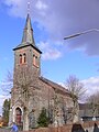
Günterod, presumably construction time 12./13. Century

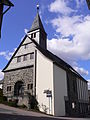
Hartenrod, inaugurated in 1858

Wommelshausen, Old Ev. Church, repair work 1269/1274 documented

Wommelshausen, New Ev. Church with an egg-shaped floor plan, consecrated in 1965
.jpg)


.JPG)


History of the school system
Source:
At the Homberg Synod in Homberg (Efze) in 1526 , with the introduction of the Reformation in the Landgraviate of Hesse, the establishment of village schools was also decided. Landgrave Philip I decided in 1537 that all village children should receive catechism instruction. As a prerequisite for the general confirmation introduced from 1574, school lessons, however modest, had to be carried out. That year the Hessische Agende was published, a book with prayers and regulations for worship services. In 1634 compulsory school attendance was introduced. The church and school visits, which were prescribed from 1627/29, strictly observed compliance with the sovereign requirements. (The spiritual school supervision was not lifted until November 27, 1918.) The parish candidates had to hold the lessons to be carried out in the parish. Whoever wanted to become a pastor had to prove himself in school service. Latin lessons must also have been given at that time, a requirement for the course. For example, Albert von Dernbach studied at the University of Marburg in 1532 and Johannes from Hartenrod in 1563 .
Already in 1623 Johannes Strauss (candidate for a parish office) can be proven as a teacher for the entire parish in Hartenrod. Reinhard Paul followed him in 1639. Since the distances were too long and dangerous for the children, especially in winter, the communities of Bottenhorn and Wommelshausen hired their own teachers. In Bottenhorn this was Jakob Paul and in Wommelshausen Lorenz Hopmann, who did school service there from 1665 to 1720. From the beginning of the 18th century, the communities Günterod and Endbach also hired their own teachers. The general compulsory education in Hessen was established on July 28, 1733 to eight years. Schoolhouses didn't exist back then. Classes took place either in the teacher's house or in turn in the other houses. It was not until the beginning of the 18th century that the government issued an ordinance that the municipalities had to build school houses. However, it took years for everyone to comply with this order.
The children from Dernbach and Hülshof went to school in Wommelshausen; the Hülshofer until 1926, from then to Bottenhorn. From 1822 to 1844 Dernbach had his own teacher. School service was carried out again from Wommelshausen until the school was built in 1878. From then on Dernbach had his own teacher again.
Due to the common school lessons that lasted for many decades, an almost identical dialect developed in Hülshof, Dernbach and Wommelshausen .
The Sütterlin script was introduced from the school year 1924/26 . Due to an order from the Reich leadership of January 3, 1941, it had to be replaced by today's normal script. Gothic letters (block letters) were also banned afterwards.
With the invasion of the Americans on Wednesday, March 28, 1945, school lessons were canceled until September 30. It began again on October 1, 1945 at 8:00 a.m. to the ringing of the church bells.
Continuing education schools as precursors of the vocational school
After the hinterland (former Biedenkopf district) became Prussian in 1867, elementary schooling was given special support. So one led u. a. In 1868 gymnastics lessons started. The communities of Hartenrod and Wommelshausen established compulsory advanced training schools from 1878 onwards, which were attended by male adolescents between the ages of 14 and 17. Günterod followed in 1899. Such a school was also established in Bottenhorn. The local teachers held classes in the evenings. Lessons were mostly canceled in the summer months. The bricklayer apprentices working outside could only take part during the construction break in winter. The aim was to provide advanced training for rural businesses and agriculture.
On April 1, 1934, the district merged all previous local advanced training schools into one district vocational school in Biedenkopf.
Making a living in the past
Development of the spa business
In 1947 the DRK sister Elfriede Geißler laid the foundation stone for a sanatorium with the construction of the “ooth ”rest home in Endbach. During a medical treatment in Giessen she got to know the head of the orthopedic clinic - Hans Storck. With his help, she set up a Kneipp bathing department in her Endbach home. Before the corresponding rooms were completed, the first treatments were carried out in the laundry room by Ms. Emilie Schmidt. An ordinary watering can served as the treatment device.
From 1950 onwards, Prof. Storck and his assistant, Dr. Nebel, with his drug-free, primarily physical-diet therapy, treating patients in Endbach with a doctor. That was the actual beginning of the Kneipp spa.
In 1950, under the leadership of Mayor Theodor Becker, a Kneipp and tourist association was established in Endbach. The community fathers of the neighboring communities of Bottenhorn, Hartenrod and Wommelshausen observed this development initially with skepticism, then with growing interest. From 1953, traffic and beautification associations were formed in these neighboring towns with the aim of participating in the emerging tourism, the "white industry". They were actively supported by the state government. The then still independent localities of Hartenrod on December 4, 1962, Wommelshausen on December 20, 1962 and Bottenhorn 1964 were each given the title of state-recognized resort .
The community of Endbach took a different path. She consistently strived for the goal of a Kneipp spa , which she achieved in 1955 and in 1970 led to the title of Kneipp spa .
The health resort in Endbach itself and the tourism in the three resorts developed in the 1950s and early 1960s always upwards and very satisfactorily. In some old agricultural outbuildings, guest rooms were set up or converted into pensions. New pensions were also created. The number of overnight stays in Wommelshausen alone rose from 5,300 in 1960 to 13,080 in 1964. After that, the number of holiday guests in the three state-approved resorts (Bottenhorn, Hartenrod and Wommelshausen) continued to decline. Endbach was initially spared.
Reasons were supra-regional influences, increasing long-distance travel, increased demands of the guests for living comfort (toilets and showers in the rooms), unattractive leisure time offers, inadequate adaptation of the restaurants to the wishes of the holiday guests as well as less willingness of the landlords to invest. The holiday guests no longer wanted to spend their 18 days minimum vacation, which has been documented since 1963, in converted barns and cow stalls , as they put it drastically. Austria and especially the dream destination Italy lured and had more to offer. Despite intensive efforts, the trend could not be reversed. In the district of Wommelshausen z. B. only operated one hotel and two holiday apartments.
The number of overnight stays in Bad Endbach (two hotels, several guest houses and holiday apartments) has now settled at a level between 58,000 and 60,000 per year.
Medicinal water and thermal water drilling
In 1890, Johannes Becker from Mornshausen (Gladenbach) had a 150 meter deep hole drilled in the valley of the salt flats northwest of the Mappesmühle and a few years later another one to the northwest of the Götzenmühle . Both wells produced sodium chloride medicinal water, which is a good prerequisite for bathing. Years of discussion about the expansion followed, which ended without result in the mid-1920s. In addition, the Staatsbad Nauheim sensed competition and thwarted all expansion plans. (see salt flats # mineral water source )
In the middle of the 1980s and the beginning of the 1990s, Bad Endbach had specific considerations to drill a well on thermal water in order to consolidate and increase the spa business . The geological conditions for this are basically given. The deep borehole in Salzbödetal, west of Bad Endbach, carried out from November 22, 2001 to April 17, 2002 with the support of the State of Hesse and the Marburg-Biedenkopf district, with a final depth of 952 m, achieved the desired success, both in terms of temperature and ingredients (Salts). A high quality thermal water was developed. The origin of the salts that rise from the fissured rock has not yet been clearly established ( Zechstein ?, Tertiary salt deposits of the Upper Rhine Rift ?). Although the amount of water is not as great as hoped, it is completely sufficient to fill the bath and compensate for the losses. In addition, there is still enough left over for other therapeutic purposes.
On the basis of a detailed usage concept, the planning for a new building was drawn up to replace the previous bathing facilities. The new thermal bath , the “Lahn-Dill-Bergland-Therme” was inaugurated in October 2009.
Bad Endbach municipality
Parish mergers
On February 1, 1971, as part of the regional reform in Hesse, the two then still independent communities of Endbach and Wommelshausen voluntarily merged (merger) to form a new community with the name Endbach. With Günterod, the third community came voluntarily on April 1, 1972.
The predicate bathroom
On October 11, 1973, the Hessian interior minister awarded the community of Endbach the rating of bath . At that time the community consisted of the three districts Endbach, Günterod and Wommelshausen.
In addition to the existing Kneipp bath title, the Hessian Minister of Economics presented the certificate of appointment to the spa on May 31, 2017 in Wiesbaden. This makes Bad Endbach the 20th spa in Hesse and, besides Bad Wilhelmshöhe, the only Hessian municipality with two spa ratings .
Incorporations
On December 31, 1971, the Schlierbach community was incorporated into the Hartenrod community. In the course of municipal reform the municipalities Bad Endbach, Bottenhorn, Dernbach, Hartenrod and Hülshof were extended to the July 1, 1974 by virtue of state law large village called Bad Endbach together .
Population development
|
|

politics
Community representation
The local elections on March 6, 2016 produced the following results, compared to previous local elections:
| Parties and constituencies |
% 2016 |
Seats 2016 |
% 2011 |
Seats 2011 |
% 2006 |
Seats 2006 |
% 2001 |
Seats 2001 |
||
|---|---|---|---|---|---|---|---|---|---|---|
| CDU | Christian Democratic Union of Germany | 36.3 | 8th | 40.1 | 10 | 36.0 | 11 | 30.6 | 9 | |
| SPD | Social Democratic Party of Germany | 42.6 | 10 | 37.8 | 9 | 35.5 | 11 | 35.0 | 11 | |
| FWG | Free community of voters | 21.1 | 5 | 18.3 | 5 | 22.5 | 7th | 23.3 | 7th | |
| UBL | Independent citizen list Bad Endbach | - | - | 3.8 | 1 | 6.0 | 2 | 5.5 | 2 | |
| FDP | Free Democratic Party | - | - | - | - | - | - | 5.5 | 2 | |
| total | 100.0 | 23 | 100.0 | 25th | 100.0 | 31 | 100.0 | 31 | ||
| Voter turnout in% | 40.5 | 39.1 | 36.6 | 44.8 | ||||||
mayor
On October 8, 2017, Julian Schweitzer was elected Mayor of Bad Endbach. In the election on September 24, 2017, none of the candidates received more than half of the votes. In the runoff election , Schweitzer, who belongs to the SPD, was able to prevail against Karina Schlemper-Latzel (non-party) with 59.5% of the vote. He replaced Markus Schäfer (CDU), who had held the office since 2005.
coat of arms
The coat of arms was approved on November 3rd, 1988 by the Hessian Ministry of the Interior.
Blazon : "In green, a silver brook running obliquely to the left between a shining golden sun breaking out of the upper right corner and an inclined golden jug at the bottom left." The coat of arms was awarded to the local community of Endbach on August 24, 1956. Since no historical coats of arms were known, the coat of arms was redesigned in 1955. Derivation: The community is an important medicinal bath, which is symbolized by the sun (fresh and healthy air and sun) and the watering can (the baths). The sloping wave band stands for the salt flats that flows through the community.
The coat of arms described above has been approved for the municipality, which was used by the former municipality of Bad Endbach until the municipalities Bad Endbach, Bottenhorn, Dernbach, Hartenrod and Hülshof merged on July 1, 1974.
Town twinning
- Ambt Montfort , (The Netherlands ) since April 18, 1988
Culture and sights
Christian communities
| local community | Districts |
|---|---|
| Protestant church | Bad Endbach / Bottenhorn / Günterod / Hartenrod / Wommelshausen |
| Free evangelical community | Bad Endbach / Günterod / Hartenrod-Schlierbach / Wommelshausen |
| Catholic Church | Hartenrod |
| Evangelical Community e. V. and EC youth work | Hartenrod |
| Christian Congregation ("Free Brotherhood") | Bad Endbach / Günterod |
| Christian Congregation ("closed brothers") | Dernbach / Günterod |
| Plymouth Brethren IV ( Raven Brothers ) | Bad Endbach |
Museums
- Art and culture house "Old School":
The art and culture house "Alte Schule" was officially opened in 1998 and is divided into three areas: the Kneipp museum, the room for temporary exhibitions and events and the gallery of the artist Brigitte Koischwitz.
The Kneipp Museum is located on the 1st floor of the house and does not cost any admission. The exhibition focuses on the history of the place after 1947. The focus is on the presentation of the upheaval and visible change from the early 1950s to the 1970s, when the poor hinterland "Kuhdorf" slowly developed into a spa village.
- Rheumatic:
A permanent exhibition on the common disease rheumatism and its therapies has been on view in the foyer of the Rheumazentrum Mittelhessen since 2008.

- Local history museum Wommelshausen:
The local history museum is housed in the former town hall / bakery in the Wommelshausen district and does not cost any admission. The kitchen as well as a living room and bedroom provide an insight into the rural world. Some groups of traditional costumes and various parts of traditional costumes document the different versions of the Evangelical Marburg and the Hinterland costume . A picture room is furnished with various sacred objects from the old church, pictures of traditional costumes from the region and some small collections. The history of the village is presented using photos, old land registers and account books. A shoemaker's workshop is reminiscent of village craftsmanship. In addition to various baking accessories, there are agricultural and forestry equipment and a wide variety of tools in the bakery.
- Natural science room in the Wommelshausen-Hütte citizens' meeting place
music
In addition to the well-known Musikverein Bad Endbach e. V. "Hinterländer Blasmusik " there are numerous church and community choirs in the municipality . a. the choral society 1875 Hartenrod e. V., the men's choir "Eintracht" 1878 Günterod, the men's choir 1884 and mixed choir Bottenhorn e. V., the men's choir "Liederkranz" Wommelshausen 1907 e. V. (dissolved), the youth harmonica orchestra Hartenrod e. V. and the CVJM Trombone Choir Wommelshausen.
Buildings

In the district of Wommelshausen stands with the old Ev. Church at the southeast entrance to the village is a remarkable building in terms of architectural history. The over 900 year old chapel is of Romanesque origin and was renovated in the early Gothic style in the 13th century . It is considered a culturally and historically significant sacred building, as it has remained almost unchanged in its epoch-typical simplicity to this day.
The rectangular building has a basic size of approx. 13.00 x 9.30 m with an average eaves height of 6.00 m and is covered with a 45 ° pitched roof with a ridge height of 5.00 m . The roof is dominated by a 10.00 m high, slim octagonal roof turret with a Gothic pointed helmet. An originally existing, transversely drawn in 6.10 m × 3.50 m choir was demolished in 1720.

The floor plan of the chapel with the excavated and proven former choir fits perfectly into the image of the simple churches from the Carolingian era, as it was with simple village churches until the 11th century. It is possible that the building was created under the influence of the Worms construction works , as it is similar to the - albeit larger and essentially much older - Magnus Church (Worms) . In the region, the bishopric of Worms (Diocese of Worms) once had many rights and extensive possessions. The Wommelshausen chapel is also very similar to the somewhat larger Romanesque Ev. Margarethenkirche (Krofdorf) , which was rebuilt in Gothic style in the Middle Ages.
The building consists of plastered double-shell quarry stone masonry made of greywacke (no hewn stone) in ample mortar bedding. The south side is still in its original condition when it was built. It has two narrow, high-lying windows with round arches on the inside and unusually compact pointed arches on the outside, which is a sign of renovation. There is another window in the west wall, which, like the once very small window in the north wall, was enlarged during earlier renovations. The former priest's gate is in the front part of the south wall and is clearly Romanesque. It was walled up and opened again during the renovation. Today it is the entrance to the chapel. The main entrance, formerly a lay entrance, is on the north side, below the rectangular window, which was later enlarged again. In the course of the extensive renovation from 1720 to 1726, the choir was demolished and its opening to the interior walled up. A striking clock from 1726 is now in working order in the Wommelshausen local history museum.
The Marburg-Biedenkopf district is the owner of the old chapel . He has given the parish of Wommelshausen the use for worship and cultural purposes.
- Ev. Church in Günterod, formerly St. Peter:
The building is a choir tower church with a parish hall of the same height. The choir tower is the oldest component, probably already in the 12th / 13th centuries. Century originated. The very thick masonry of the choir tower indicates its former function as a defense tower. The medieval ship was attached later, as with the church in Niederweidbach. Choir tower churches were the predominant building type in the Lahn-Dill area in the Middle Ages. The basement of the choir tower serves as a chancel, in the low pointed helmet roof hang two bells from the years 1452 and 1453. The medieval nave with a pseudo-mansard roof has been rebuilt and expanded several times. The entire structure consists of irregular quarry stone masonry (greywacke). The pulpit dates from 1662; the galleries were built in 1664, 1680, 1731 and 1804–1809, expanded and rebuilt in 1954–1956. The art-historically significant parapet paintings were created in 1809.
.jpg)
- Viaducts and tunnels of the former Aar-Salzböde Railway
The Aar-Salzböde Railway runs over three viaducts at Wommelshausen-Hütte, Endbach and in Hartenrod as well as through a tunnel between Hartenrod and Eisemroth.
The so-called Salzbödeviadukt near Endbach (km 16.9) has nine arches, is 165 meters long and 15 meters high. The viaduct is now a landmark of Bad Endbach and is illuminated at night.
The 150 meter long and 13 meter high viaduct over the Schlierbachtal in Hartenrod (km 20.1) was built using the same construction method. It also has nine arches.
The viaduct at Wommelshausen-Hütte (km 16.5) is about 25 meters long, 11 meters high and has three arches.
The strongly curved tunnel below the Salzböde / Aar or Lahn / Dill watershed between Hartenrod and Eisemroth (km 21.6 to 22.3) is 700 meters long.
.jpg)
- Observation tower
An observation tower has been installed since March 2014, offering a good view of Bad Endbach and far into the surrounding area
See also: List of cultural monuments in Bad Endbach
Parks
.JPG)
- Kneipp spa park:
The Bad Endbacher Kneipp spa park extends from the health center in the west along the Grundweg and the salt flats to the community center in the east. There is a pond, a 550 meter long barefoot path , a modern Kneipp treading pool , a herb garden, a roller skating rink and a playground.
- Hintermühle spa park:
At Wommelshausen on the edge of the forest in the Dernbach Valley, the Hintermühle spa park with another Kneipp treading pool offers the opportunity to explore the effects of the clear stream water.
Forest cemetery

In the district of Wommelshausen there has been a forest cemetery ( funeral forest ) for urn burials right next to the new cemetery since 2012 . It was laid out on the oldest part of the "Old Cemetery", which was closed in 1926 and was now covered with trees, in its northwest corner, directly opposite the Memorial to the Fallen (war memorial).
Natural monuments

-
Howling Oak:
 "Heul-Eiche", on the left the old direct high path ( Westfalenweg ) from the hinterland to Giessen

On a 425 meter high mountain saddle in the natural area of the Zollbuche , on the old direct and until 1854 only duty-free route from the Hessian hinterland to the former provincial capital Gießen, there is an oak that is around 350 to 400 years old. It has a height of 25 meters and a crown diameter of about 24 meters. The trunk circumference is 4.25 meters (measured at a height of 1 m). Its location approx. 10 meters behind the municipal boundary of Bad Endbach (Wommelshausen district) in the Gladenbach municipality (Weidenhausen district) identifies it as a former border tree. In the past and up until the construction of the Aar-Salzböde Railway , traveling merchants (“stocking men”), traveling workers (mowers, reapers and threshers on their way to the Wetterau) and drafted soldiers were tearful from their relatives and soldiers Farewell to friends. Hence its name "howling oak".


The oak stands on the formerly important Fernweg ( Westfalenweg ), which until 1866 connected the Hesse-Darmstadt hinterland by the shortest route with its provincial capital Gießen, the southern parts of the state and the state capital Darmstadt. The L3047 (Zollbuche - Gießen) largely runs along the old route.
During the First and Second World Wars, the howling oak was once again a farewell tree, this time in the opposite direction. For the soldiers called up from Bischoffen-Oberweidbach, the train station in Wommelshausen-Hütte was the closest.
- Thick oak:
In the new development area Am Gewenn in Wommelshausen, on Weidenhäuser Weg opposite the entrance to the sports field and at the junction of the crossbar from Landstrasse, there is another remarkable oak. It has a crown oval of 20/16 meters and a trunk circumference of almost five meters (at a height of one meter). Their age is estimated to be 450 to 500 years. A lightning strike around 90/100 years ago is said to have lost its large southern fork.
- Fan Linden:
The linden tree at the monument to the fallen in Wommelshausen was named after its growth / appearance as a result of a strong cut back about 60/70 years ago. It was planted on the occasion of the inauguration of the memorial on October 22, 1933.
- Kaiserlinde:
South of Wommelshausen an der Landstrasse, opposite the cemetery at the old Dreschplatz, is the imperial linden tree, which was planted in the three Emperor's year of 1888 .
- Hermann Löns beech:
The Hermann Löns Beech between Schlierbach and Bottenhorn was "inaugurated" on August 2nd, 1953. Today, however, the place is hardly signposted, as it is forbidden to stay under the tree due to falling branches.
Sports
hike
The wooded, hilly natural landscape around Bad Endbach is ideal for hiking. In addition to a predicate hiking trail, there are 24 other hiking trails, including a. Circular hiking trails available. There are also Nordic walking trails and bike paths (e.g. Salzböderadweg).
From various high places there are remarkably good round and far views (panoramic views) z. B. to Dünsberg (15 km), to Marburg (20 km), to the Frauenberg castle ruins (21 km) and on a clear day to the Fuchskaute (29 km) in the Westerwald , to the Knüllköpfchen (68 km) in the Knüllgebirge, to the Hoherodskopf (60 km) in the Vogelsberg, to the Feldberg (64 km) in the Taunus, to the Hohen Wurzel (83 km) near Wiesbaden, to the Ederkopf (26 km), to the Sackpfeife (18.5 km) near Biedenkopf, to the Kahler Asten (44 km) Winterberg and with extremely good visibility even as far as the Wasserkuppe in the Rhön (100 km).
These lookout points are the Endbacher Platte (forest restaurant closed since 2006), the Schönscheid near Günterod, the Wade between Wommelshausen and Endbach, the Green Stone (Omisseberg) near Dernbach, the southern edge of the Bottenhorn plateau north of Wommelshausen, near Hülshof, here e.g. B. the refuge "Am Stein" northwest of Wommelshausen and especially the Scheid (538.7 m) 1 km east of Bottenhorn (location of a drinking water reservoir).
Nordic Walking Park
The Bad Endbach Nordic Walking Park comprises a route network of around 30 km with a total of 6 selected tours between 2.5 km and 11.7 km in length.
Mountain bike / flow trail
To the west of Bad Endbach there is a so-called "flow trail" - a designated mountain bike route with special obstacles.
Winter sports
On the Bottenhorn plateau, at Hülshof and Bottenhorn, cross- country trails are groomed in winter . In Hartenrod there is a winter sports area with a downhill slope and ski lift . In summer the slope is used by grass skiers .
Regular events
hike
Whitsun and autumn hiking week, GPS-guided day hikes, themed hiking tours, extra tours in the Lahn-Dill-Bergland, Nordic walking, hiking wellness days from April to October and the Bad Endbach hiking marathon on the first Sunday in November
Others
Music days, spa concerts, skat evenings, dance evenings, tea dance, tours, video presentations, chess evenings, embroidery circle, “A woman's theater”, shooting for guests
Sons and daughters of the church
- Bernd Fischer (* 1936), mathematician
- Egon Vaupel (* 1950), Lord Mayor of Marburg from 2005 to 2015
Economy and Infrastructure
Land use
In 2015, the municipal area covered a total of 3964 hectares, of which the following were accounted for in hectares :
| Type of use | 2011 | 2015 | |
|---|---|---|---|
| Building and open space | 264 | 265 | |
| from that | Living | 164 | 165 |
| Business | 14th | 14th | |
| Operating area | 21st | 23 | |
| from that | Mining land | 12 | 12 |
| Recreation area | 25th | 26th | |
| from that | Green area | 10 | 11 |
| traffic area | 336 | 336 | |
| Agricultural area | 1585 | 1581 | |
| from that | moor | 0 | 0 |
| pagan | 0 | 0 | |
| Forest area | 1702 | 1702 | |
| Water surface | 28 | 28 | |
| Other use | 28 | 28 | |
Economic structure
As a health resort, Bad Endbach lives today mainly from health resorts and tourism . Two hospitals / rehabilitation centers are important, namely the Hessische Berglandklinik and the Rheumazentrum Mittelhessen , as well as senior citizens' homes and nursing homes. There are no larger industrial and commercial enterprises in the municipality.
Health and hiking tourism are therefore an important economic factor. In 2007 there were more than 60,000 overnight stays in health and hiking tourism; in 2019 there were 57,234.
Health resort and tourism


The Kneipp spa has therapeutic indications for the following diseases:
- Heart, vascular and circulatory diseases
- Diseases of the postural and locomotor organs
- Digestive system diseases
- Nervous system disorders
In particular, special compact cures against migraines and chronic headaches are carried out in Bad Endbach , which is so far unique in Germany. A total of around 550 beds and 14 doctors are available for the spa operation. Today Bad Endbach offers specialized offers for migraine therapy and vein cure as well as clinic aftercare. The health offers include Schroth cures , food combining , drinking cures , aromatherapy , post-accident treatment, active vacation , fitness week , back program, therapy for osteoarthritis , all-inclusive cures , Kneipp pedaling equipment , geriatric treatment and various wellness programs.
Health center "Lahn-Dill-Bergland-Therme"
The Bad Endbach health center was opened in 1976 and was in operation until autumn 2009 with an exercise pool , sauna area , steam baths, solariums, therapy center, fitness and wellness studio and a cafeteria.
Since May 2008 the thermal baths , the new Lahn-Dill-Bergland-Therme, have been built next to the existing health center. The commissioning took place in October 2009. The old center was demolished and the area freed up as a result was partly used as a parking area and the rest was integrated into the green area. In the new health center of the Lahn-Dill-Bergland-Therme there are five pools (thermal water from over 900 m depth), hot tubs with massage jets, neck jets, bubble beds with a water temperature of up to 34 ° C. In addition, the health center offers wellness, fitness and beauty worlds. The sauna landscape includes five saunas between 60 ° C and 100 ° C and steam baths. There is also a Dead Sea salt grotto. A cafe-restaurant with beer garden is integrated into the health center.
Streets
In the years 1817 to 1825 the oldest art road from Biedenkopf via Gladenbach, Weidenhausen to the Zollbuche was built. From the customs beech , the old Westfalenweg was expanded in the direction of Gießen into a modern street. He had already been chaused in parts during the reign of Napoleon (1796-1813).
The most important old road connection in the municipality, which was used from the high Middle Ages until 1865, was the Obergerichtsweg, also called the Botenweg or Amtsweg , between Marburg, Gladenbach and Dillenburg / Herborn . It was laid out as a valley road and ran south from Gladenbach (Blankenstein Castle) to Kehlnbach and north to Weidenhausen, Hütte and Endbach past through Hartenrod over the Salzböde-Siegbach watershed towards Eisemroth. There it branched in the direction of Dillenburg and a southern route to Herborn. In the course of the Obergerichtsweg the Schoofponz Bridge over the Dernbach above Wommelshausen-Hütte was renewed again in 1852.
Today's road (L 3050) from Weidenhausen via Hütte and Endbach to Hartenrod was built between 1860 and 1865. The Bottenhorn – Steinperf road in the Hausebachtal was built between 1878 and 1880. In the years 1906/07 the road between Endbach and Günterod was built. From 1912 to 1913, the roads from Hütte via Wommelshausen and Hülshof to Bottenhorn and the branch to Dernbach were built.
Between 1923 and 1925, the Prussian state had the Günterod – Bischoffen road built as an emergency work for the unemployed. The extension of the country road from Hartenrod to Eisemroth (L 3050) on the old route of the Marburg-Herborner Amtstraße in the years 1924 to 1926 was carried out as an emergency measure.
All roads used to have only a water-bound gravel cover, including all inner-city paths. This remained so until the 1950s. Only the road from Weidenhausen via Hartenrod to the Dillkreis was covered with tar before the Second World War. The gray-green sand from the top layers of the diabase and green quarries was used as the cover sand for rolling the water-bound gravel roads. It is particularly suitable for this purpose, as it becomes very solid when sprinkled with water. From today's perspective, the subordinate direct local connection routes and the few dirt roads in front of the land consolidations were almost all in poor to very poor condition, as they were subject to the sole care of the municipalities.
Along the edges of the “Vizinalwege” - as the country and district roads were formerly called - the municipalities had to plant fruit trees (apple, pear or cherry trees) by order of the government. The fruit was auctioned by the municipalities at the highest bidder in autumn. These trees were gradually felled from the end of the 1950s, when they were sacrificed for road construction and were also held responsible for numerous fatal road accidents. Above Wommelshausen, on the roads to Dernbach and Hülshof / Bottenhorn, for example, there were many cherry trees, a widely known cherry tree avenue.
It was not until 1952 to 1956 that the long-desired connection via Rachelshausen, “Landratskreuz” to Bottenhorn was built. In 1961/62 the alignment of the route from the Landratskreuz via Dernbach to the branch north of to Wommelshausen was decisively improved .
The L 3050, which runs from east to west in the Salzbödetal, is the main road through Endbach . Via the connection to the B 255 in Weidenhausen, it represents the link to the national traffic. The road section from Weidenhausen to Wommelshausen-Hütte was generously expanded in 1968/69 and Wommelshausen-Hütte was relieved by a bypass.
In the Hut district, the 3049 road branches off from the L 3050 and connects the Bottenhorn, Hülshof and Wommelshausen districts to the north. Dernbach can be reached via the L 3049 - Landratskreuz link .
train


As early as 1850, the Bergisch-Märkische Eisenbahn-Gesellschaft wanted to build a railway line from Altenhundem via Laasphe and Bottenhorn to Giessen . The execution failed u. a. also in the fierce resistance of the Bottenhorn mayor and his community board with the argument: This would bring too many foreign people to here .
Until the construction of the Aar-Salzböde Railway , the nearest train stations were in Fronhausen an der Lahn and in Dillenburg . From 1890 work began on the new route, the first section Niederwalgern – Weidenhausen was opened to traffic on May 12, 1894. From 1898 to 1902 the line to Herborn was continued. The section from Wommelshausen to Eisemroth was very complex because of the three viaducts at Wommelshausen-Hütte, Endbach and in Hartenrod and the 700 m long tunnel between Hartenrod and Eisemroth.
On July 24, 1899 the foundation stone was laid for the Salzbödeviadukt near Endbach. “The entrepreneur had almost only Polish workers for the excavation work, while almost only Italian workers for the masonry and other work. Despite the different languages spoken by the workers, the work has so far proceeded consistently and without disturbance. “The viaduct has nine arches, is 175 meters long and 18 meters high. The building, which lies in a curve, was planned by the iron construction inspectors Hentzen and Pietig. Today the viaduct is a landmark of Bad Endbach.
The approx. 155 m long, imposing viaduct over the Schlierbachtal in Hartenrod was built using the same construction method. The approximately 25 m long viaduct at Wommelshausen-Hütte had been completed beforehand. In addition, a 700 m long tunnel had to be dug below the Salzböde / Aar and Lahn / Dill watershed between Hartenrod and Eisemroth.
On July 15, 1901, the Weidenhausen – Hartenrod section was opened to traffic. On August 1, 1902, the first train ran from Niederwalgern to Herborn, connecting the hinterland with the national rail traffic on the Main-Weser Railway and the Dill route .
At the end of March 1945 a mysterious train crossed the southern hinterland on the Aar-Salzböde Railway. It was the almost 1.5 km long military train, pulled and pushed by four locomotives, a mobile V2 rocket artillery unit with launching ramps, which was to be relocated from the Westerwald to a new northeast launch position. It reached Bischoffen on March 22nd. The train reached the tunnel near Hartenrod with difficulty under enemy fire in the evening, from where it was driven on two days later. In Bromskirchen the Americans stopped the train on March 29, he went to Antwerp and then shipped the captured 10 missiles into the United States.
At the beginning of the 1950s, blasting chambers were built into the two bridge piers of the Salzbödeviadukt between Endbach and Wommelshausen-Hütte to the left and right of the country road. In the event of a feared attack from the former Eastern Bloc states, the bridge should B. be blown up by the Red Army . This was intended to hinder a rapid advance of opposing troops. Blasting chambers were built in almost all important rail and road connections during the “Cold War”, especially when the routes were east-west.
On June 9, 2001 the railway line was shut down and the rails were dismantled in sections in the following years.
air traffic
Within the municipality there is an airfield in the district of Bottenhorn with a 525 m long grass runway . It is designated as a special landing site and has the ICAO code EDGT. The operator is the Luftsportgemeinschaft Bottenhorn e. V.
schools
As a result of the Hessian school reform, the local elementary schools were to be dissolved in favor of central schools from 1960. A new center school in Hartenrod began teaching on April 18, 1966. The primary schools in Wommelshausen, Dernbach and Günterod were gradually dissolved. Today not all pupils from the community go to the central school in Hartenrod, the districts of Dernbach, Günterod and Wommelshausen have to send their children to the school in neighboring Weidenhausen .
There are still primary schools in Bad Endbach (Berglandschule) and Bottenhorn (primary school at Lindebaum). The central school Hartenrod is a primary , secondary and secondary school with a special level .
There are kindergartens in the five larger districts of Bad Endbach, Bottenhorn, Günterod, Hartenrod and Wommelshausen .
energy
The Hilsberg wind farm was built in the municipal area and is fully municipal owned. With this, the municipality is also pursuing the goal of generating at least 20% of its electricity from renewable energies by 2020 and increasing energy efficiency by 20%. The first year of operation of the wind farm made a significant contribution to the fact that Bad Endbach can call itself a “climate protection community”.
Others
Mills
“No bread without a mill” was what they used to say. Therefore, if the local geographic conditions allowed (watercourse with sufficient water quantity), every village had at least one, often even several mills one after the other on the same creek. The construction of a mill always had to be approved by the sovereign / landowner. In addition to private mills, there were also landgrave mills that were given as fiefs.
A mill in Endbach is mentioned for the first time on April 13, 1366, which Landgrave Heinrich I lent to the knight Rudolf Scheurenschloß. In 1496 the "Schillingsmühle" appears in documents in Wommelshausen-Hütte, which in 1499 is also referred to as a blacksmith's (forest forge) (location: today's Hüttner-Mühle ), in 1571 the "Burgmühle" of the Lords of Dernbach near Dernbach, in 1577 the "Plockemühle" appears in Wommelshausen-Hütte, in 1586 a mill in Hartenrod, the upper “Hankopfsmühle” is mentioned and in 1703 the “Hintermühle” in Wommelshausen at the confluence of the Lembach and the Dernbach .
Twelve mills are documented for the year 1630 in today's municipal area. Of these, three were in Bottenhorn on the upper reaches of the Perf below the local situation, namely: the mills of Theis Möller, of Endres Meyer and by Jaeckel and Kunz Pfeiffer. In the district of Dernbach the "Burgmühle" stood at the confluence of the Dorfbach in the Dernbach , southeast below the castle hill and the former lower fish pond. Wommelshausen had two mills (probably both on the salt flat ). The two mills in Hartenrod were on the lower reaches of the Hulsbach ; these were the upper (later called “Daniels mill”) and the lower Hahnkopf mill . There were four mills in Endbach on the Salzböde, namely the "Heckenmühle", "Dörrmühle", "Hohkäppersmühle" and "Krebsmühle".
In 1830 the statistics look as follows: Bottenhorn one mill ("Feldesmühle"), Wommelshausen three ("Hintermühle", "Hüttner-Mühle" and "Plockemühle"), Hartenrod three ("Obere Hahnkopfsmühle", "Untere Hahnkopfsmühle" and "Schmidtsmühle" at the confluence of the Hulsbach in the Salzböde) and the aforementioned four mills in Endbach. This list does not mention the mills that only existed for a short period of time, were shut down or not leased at the time of the inventory, such as the "Schillingsmühle" (shut down for a long time, later called Hüttner mill ) at Hütte, or have become desolate . Furthermore, the mill with an unknown name at Mehlmerk (field name "Mehlwess"> Mühlwiese) in Wommelshausen below the village, at the location of the Nieder-Wommelshausen desert, at the confluence of Dernbach and Wommelshäuser Dorfbach , which was knocked off by its last owner in 1725. There is also no windmill belonging to the Lords von und zu Dernbach south of Neu-Dernbach Castle on the mountain nose, today's house name Wendmellersch . No further data are known from her.
All mills that were not on the salt flats were dependent on water reservoirs (mill ponds) because of the low flow of water in the streams, that is, they could only grind if they emptied their ponds (between 150 and 500 m³) or if there was enough water in the stream raft. Then the ponds had to be refilled until the next grinding cycle. This also explains why two mills were often located on the same stream at these locations, for example in Bottenhorn or Hartenrod (upper and lower Hankopfsmühle). The lower mill used the running water from the upper mill.
The millers kept donkeys as sack-carriers for the transport of the grain and flour. In Wommelshausen-Hütte, for example, there was the field name "Eselspädche" (donkey path). That was the path on which the donkeys went to the customers in Römershausen.
Today all mills are shut down.
Bakehouses
Each district used to have its own bakery , Bottenhorn and Wommelshausen even two. The Plocke mill and the four farmsteads on the Hülshof had their own small bakeries. The upper floor of the community bakeries was often used by the mayors and the community council (e.g. Dernbach, Bottenhorn and Wommelshausen) as an office and a meeting room. There were an oven or two in the basement.
Baking used to have a very special meaning; Bread was the main food. Almost every family with enough flour baked their own bread. The sourdough bread dough was prepared at home, shaped into loaves and carried to the bakery on baking boards. The order of who was allowed to bake and when was determined by drawing lots one week in advance and written on a board in the bakery. Even the Sunday cake (usually the so-called sheet cake ) was baked here on Saturday, if you didn't let the baker bake it. The bakeries were still in frequent use well into the 1960s. They were then shut down, fell into disrepair and were torn down, with a few exceptions.
- Bakehouses

Backhaus Bottenhorn, formerly also the town hall, is used sporadically

Backhaus Dernbach, formerly also town hall, now private property

Backhaus Wommelshausen, formerly also town hall, today local museum
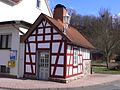
Backhaus, Wommelshausen-Hütte, is used sporadically


As part of a reconsideration, citizens have renovated some bakeries. Today the Backes , as the bakeries are called in the dialect, is used sporadically again in Bottenhorn and Wommelshausen-Hütte. In Dernbach it has become an attractive holiday home and the local museum is housed there in Wommelshausen.
Ortsnecknames
All of the localities in the Bad Endbach community have village names, mock names or nicknames , as can be found everywhere in Germany . The naming is mostly in the dark. It is said to be based on special circumstances, prominent characteristics or habits of the residents and are usually derived from the dialect , i.e. the hinterland Platt . Every inhabitant of the place was given the village nickname during teasing or quarreling.
The nicknames of the individual districts are:
- Bottenhorn: Nonn (fools)
- Dernbach: Waaldradde (Wald = rats Siebenschläfer ) or robbery Ridder = Raubritter
- Endbach: Rasselbäck (rascals)
- Günterod: Foiselongsschesser (Sockenschisser, Foiselong = foot part of the stocking)
- Hartenrod: mice (mice)
- Hülshof: Kräbbel (flour or potato pancakes, called "Schäbbkräbbel")
- Hut (district of Wommelshausen): Schnappsaik (Schnappsäik = shoulder bags for dry food when traveling)
- Schlierbach: Härekernsweschde (heather grain sausages , heather grain = buckwheat )
- Wommelshausen: Rendviehcher (cattle)
House names
The tradition of house names lives on in the community of Bad Endbach to this day. House names are names for a house, an estate / yard including all the buildings there. All residents living there are assigned the house name. When naming a person, the house name is always placed in front of the nickname z. B. "Gehanns Walter" (house name Gehanns ) or "Lisbets Hilde" (house name Lisbets ). A house name is an epithet, quasi a second family name in the local dialect, which is only used orally and passed on. The most popular first name for men was formerly Johannes (Johann), for women Elisabeth and its variants in the dialect.
House names originated at a time when house numbers did not yet exist. For the sovereign and his administration, however, it was important to mark the individual homes of the subjects by name, so that they could be used for taxes and duties. Did a subject live B. with a Born, the tax collector kept him in his documents z. B. as Johann near Born , someone else who lived on the mountain as Heinrich am Berg or someone who lived in the valley as Adam in der Tal or as Velten am Ende , because he lived at the end of the village. From this z. B. the family names: Beimborn , Amberger> Bamberger , Intertal and Amend . In more recent times, family names have been and are becoming house names again (e.g. Beimborns, Innerdols, Menn, Schmitts). House names also arose from field names, e.g. B. Former living space in the hallway Hahnkopf , mdal. Hohkopp> Hohkäppersch or special features of the living space in connection with the family name, e.g. B. Living space in a narrow valley> Schmitts im Loch or Kochs who lived on the heights were called> Hiekochs (Höhenkochs).
Most of today's house names, however, can be traced back to the first names and their short forms or derivatives (in dialect form) of the first owner. In addition, professions are eponymous and their combination with existing house names.
- Examples: Adam → Orm → Orms ; Johann-Adam → Hannorm → Hannorms ; Christian → Chress , from it e.g. B. also double name → Chressgehanns ; Georg → Jerch → Jerje ; Johann-Georg → Hannjer → Gehannjersch ; Johannes → Gehann → Gehanns , also → Handes ; Johann-Jakob → Hanikob → Hanikobches ; Johann-Daniel → Hanndingel → Gehanndingels ; Johann-Philipp → Hannphilipp → Hannphilipps ; Johann-Peter → Hannpirrer → Gehannpirrersch ; Jost-Jakob → Jukob → Jukobs ; ; Heinrich → Henner → Hinn → Hennrichs → Hinnersch ; Peter → Pirrer → Pirrersch → Pirrerches ; Valentin → Velten → Veltes → Fäldes ;
- Elisabeth (a) → Lisbeth → Lisbets , Elbet or Elwert (modified forms) → Elwerts , or → Bettche → Bettches ; Katharina → Kottche → Kottches or → Kottreis or Katharina → Kathrein → Crain / Krein (old form) → Krein ; Margaretha → Moigreh → Moigrits or Moigrehs ; Anna → Ännche → Ennches ; Luise → Lu'wies → Wies'che → Wies'ches or Wiese ; Emilie → Mielche → Mielesch
- Wagner → Warsch , also shortened by Gehanns-Warsch → Hannwarsch ; Carpenter → Schreinesch ; Köhler → Kählesch , Koch → Kochs ; Blacksmith → Schmidde → Schmidden
If someone from the village built their own new house / property in the village, the woman usually took the house name with her, which was then given attributes (in dialect) in front of the old name such as: old, new, above, below, back, front , depending on the location of the new property to the parent company, z. B. "onne Elwerts", "owe Schreinesch", "henne Handes", or "ahle Gehanns", when referring to the parent company.
Today every older property in the individual districts still has its own house name, which in most cases is independent of the family name. In the case of new buildings, one helps oneself with paraphrasing until a new name has solidified.
The house names are still in common use. If someone died in the village, it is said e.g. B. not "Karl Schneider died", house name "Hannorms", but "Hannorms Kall died", because he is only known by this house name. The family name is secondary. If he is not known what happens more often, one asks: "How does (family name) actually write?".
- House names in Bottenhorn and Hülshof


The tradition was revived in Bottenhorn , Hülshof and Wommelshausen , also in the neighboring village of Rachelshausen . Here homeowners have put their house names on the house on the street side.
literature
Writings on local anniversaries
- Alfred Bastian: Looking for traces in the history of Günterod . Ed. Festival committee “700 Years Günterod”, 1998.
- Local festival 675 years Schlierbach 1318–1983 . Edited by the Festival Committee 675 Years of Schlierbach GBR, Bad Endbach 1983.
- Horst W. Müller: Wommelshausen 1336–1986 A village book . Hrsg. Heimat- und Verschönerungsverein Wommelshausen e. V. Bad Endbach. 2nd edition, 262 pages, Marburg 1995.
- Karl Heinrich Staus, Hannelore Kautzsch: Bottenhorn 1253-2003 . Ed. Association for the Promotion of Charitable Tasks Bottenhorn e. V. 2003.
- Walter Zimmermann: 700 years of Hülshof . Lecture on July 7, 1984, published. in the community bulletin of the community Bad Endbach No. 30, Bad Endbach 1984, pp. 2-4.
- 675 years Wommelshausen 1336–2011, historical overview and life pictures from the middle of the last century. Published by Dorfgemeinschaft Wommelshausen e. V., “Chronicle” working group. L&W Druck, Bad Endbach 2011.
- Hartenrod, Through the ages 1311–2011. Ed. Festival Committee 700 Years Hartenrod. L&W Druck, Bad Endbach 2011.
- Ulrich Stork: 750 years of Bad Endbach, from a small village to a respected health resort. Edited by Förderverein Bad Endbach e. V. L&W Druck, Bad Endbach 2011.
- Horst W. Müller: 675 years of Wommelshausen. In: Hinterland history sheets. Biedenkopf, No. 3, September 2011, pp. 145–150.
Local history
- Karl Huth : Endbach. Kneipp spa for veins and joints. Wetzlarer Verlag-Druckerei, Wetzlar 1963.
- Karl Huth: Hartenrod in the past and present. Ed. Community board of the community of Hartenrod. 1974.
- Karl Huth: The community of Bad Endbach and its 8 districts through the centuries. Published by the community council of Bad Endbach. 1985.
- Gerald Bamberger: “Leave the church in the village”. The history of the churches and chapels in the old parish of Hartenrod. Edited by the Ev. Parish Bad Endbach, Bottenhorn with Dernbach and Hülshof, Günterod, Hartenrod with Schlierbach and Wommelshausen. Gladenbach 1997.
- Gerald Bamberger: 150 years of the Evangelical Church in Hartenrod 1858–2008. Festschrift for the anniversary week, contributions to the history of the church buildings and the parish in Hartenrod. Ed. Evangelical Church Community Hartenrod. Druckhaus Marburg, 2008.
- Theodor Becker: Bad Endbach in old views. Zaltbommel / Netherlands 1979.
- Old Churches Support Group : Abandoned Church of Wommelshausen. Edited by the old churches sponsorship group. Marburg 1985.
- Hans Griesing: 125 years of the Evangelical Church in Hartenrod: 1858–1983. Festschrift for the anniversary week from 3 to 11 September 1983. Published by the parish council of the Evangelical parish of Hartenrod. Hartenrod 1983.
- Hildemarie Grünewald: Evangelical Church Wommelshausen. Festschrift for the inauguration on August 29, 1965. Ed. D. Grünewald, H. Grünewald. Weidenau (victory) 1965.
- Horst W. Müller: 50 years of the Heimat- und Beautification Association Wommelshausen e. V. Wommelshausen as a tourist destination. Hrsg. Heimat- und Beautification Association Wommelshausen. Wommelshausen 2003.
- Chronicle of the Wommelshausen School 1870–1969. handwritten; Editing and text transfer of the facsimile edition: Volker Schneider, Wolfgang Pfeifer, layout: Volker Schneider; Ed. Chronicle Working Group, Dorfgemeinschaft Wommelshausen e. V., Bad Endbach 2011.
- Rudolf Klein, add. Jakob Pfeifer: Village chronicle of the community Wommelhausen. handwritten 1964; Editing and text transfer of the facsimile edition: Volker Schneider, Wolfgang Pfeifer, layout: Volker Schneider; Ed. Chronicle Working Group, Dorfgemeinschaft Wommelshausen e. V., Bad Endbach 2011.
- Literature about Bad Endbach in the Hessian Bibliography
Cross-community sources
- "Hinterland history sheets". different years, publisher Hinterländer Geschichtsverein e. V., Biedenkopf.
- Elsa Blöcher : The hinterland, a home book. revised and supplemented new edition. Stephani, Biedenkopf 1981. DNB 820377600 (first edition 1953)
- Dieter Blume, Jürgen Runzheimer : Gladenbach and Blankenstein Castle. Ed. Kur- und Verkehrsgesellschaft Gladenbach mbH. Dr. W. Hitzeroth Verlag, Marburg 1987.
- Hans Friebertshäuser : The women's costume of the old office Blankenstein. (= Contributions to the folklore of Hesse. Volume 5). NG Elwert Verlag, Marburg 1966.
- Ute Gerst, Brigitte Bieber-Burk: 700 years of Bischoffen 1299–1999. Ed. Festival Committee “700 Years of Bischoffen”. 1999.
- Hans Werner Koob, Margot Lipp: Weidbach 1200 years 802-2002. Ed. Interest group Weidbacher Vereine e. V. Marburg 2002.
- Ulrich Lennarz: The territorial history of the Hessian hinterland. Hessisches Landesamt für historical Landeskunde in connection with the Hinterland history association. Marburg 1973.
- Horst W. Müller: Living conditions in the hinterland - The southwestern hinterland at the end of the 18th to the beginning of the 20th century. In: Hinterland history sheets. Biedenkopf, No. 1, March 2016, pp. 97–101.
- Ulrich Reuling : Historical local dictionary Biedenkopf, former District. Booklet 4, published by the Hessian State Office for Historical Regional Studies. Marburg 1986.
- Dieter Stoppel: Looking for ore, on the history of silver, copper and heavy spar mining in the Biedenkopf-Dillenburg area. D. Bode Verlag, Haltern 1988, ISBN 3-925094-19-9 .
Web links
- Bad Endbach, Marburg-Biedenkopf district. Historical local dictionary for Hessen. In: Landesgeschichtliches Informationssystem Hessen (LAGIS).
- Link catalog on Bad Endbach at curlie.org (formerly DMOZ )
Individual evidence
- ↑ Hessian State Statistical Office: Population status on December 31, 2019 (districts and urban districts as well as municipalities, population figures based on the 2011 census) ( help ).
- ↑ Predicates put to the test - awakening from slumber. In: Oberhessische Presse , accessed on March 25, 2016.
- ↑ a b Hessian Statistical Information System In: Statistics.Hessen.
- ↑ Otto Schäfer: Traces of old settlements in the southwestern hinterland ; Hinterland history sheets, Biedenkopf. No. 1, 1966, pp. 33-35
- ↑ Hans Friebertshäuser : The women's costume of the old office Blankenstein , NG Elwert Verlag, Marburg 1966
- ↑ Hans Friebertshäuser: Language and history of northwestern Althessen (= German dialect geography. (DDG). Bd. 46, ZDB -ID 504227-6 ). Elwert, Marburg 1961.
- ^ Hans Friebertshäuser: Country and City in Transition. Dialect and rural working world in the Marburg Biedenkopf district. Sparkasse Marburg-Biedenkopf, Marburg 1991
- ^ Ulrich Lennarz: The territorial history of the Hessian hinterland. Ed. Hessian State Office for Historical Regional Studies, NG Elwertsche Verlagsbuchhandlung, Marburg 1973, p. 31.
- ↑ Horst W. Müller: "Dernbach 1255?" On the first mention of Dernbach, Bad Endbach community. In: Hinterland history sheets. Biedenkopf, No. 3, November 2013.
- ↑ Horst W. Müller: Dernbach and the 'von Dernbach'. In: Hinterland history sheets. Biedenkopf, No. 3, October 2005, No. 4, December 2005, No. 1, March 2006 and No. 2, June 2006.
- ↑ Main State Archive Wiesbaden W 170 Urk .; Koch and Wille No. 1672
- ↑ Main State Archives Wiesbaden W 171 C825, 826 f. 475 u. 478
- ↑ Horst W. Müller: The Central Hessian Landheegen. In: Hinterland history sheets. Biedenkopf, Volume 89, No. 4 December 2010.
- ↑ Friedrich Uhlhorn : Border formations in Hessen, The development of the western border of the district of Biedenkopf. In: Boundary factors in history. ( Research reports of the "Historical Spatial Research" committee. Volume 48). Edited by the Academy for Spatial Research and Regional Planning. Gebr. Jänecke Verlag, Hanover 1969.
- ↑ Peter Bender, Hans-Joachim Lippert, Heinz-Dieter Nestor: Explanations for the Geological Map of Hesse 1: 25000, sheet no. 5216 Oberscheld. 2nd, revised edition. Hessian State Office for Soil Research, Wiesbaden 1997, ISBN 3-89531-061-1 .
- ↑ W. Franke: Rhenohercynian foldbelt: autochthonous and nonmetamorphic nappe units - stratigraphy. In: D. Dallmeyer, W. Franke, K. Weber (Eds.): Pre-Permian Geology of Central and Western Europe. Springer, Berlin / Heidelberg 1995, pp. 33-49.
- ↑ H. Huckriede et al. a .: Plate tectonic setting of allochthonous units in the Rhenohercynian belt: new insights from detritus analysis of synorogenic sediments. In: Terra Nostra. 99/1, Cologne 1999, p. 109.
- ↑ H. Huckriede: The Barytlager of Günterod in dill trough (Rhenish Massif, Germany): an allochthonous plaice in give-Nazi debris flow sediments. Geol. Jahrbuch Hessen 120, Wiesbaden 1992, pp. 117-144.
- ↑ Main State Archive Wiesbaden, Certificate W 171 C 825
- ↑ Horst W. Müller: The "Hüttner Hütte", a contribution to the settlement history of Wommelshausen-Hütte. In: Hinterland history sheets. Biedenkopf, No. 1 March 1983, p. 23; Addendum No. 2 June 1983, p. 32.
- ↑ Main State Archives Wiesbaden, Certificate W 171 C 825, 826 f. 475 u. 478
- ↑ Ph. E. Klippstein: Mineralogical letters. Giessen 1781, p. 57.
- ↑ Hiking on historical paths - GRENZGANG Reimar Debus guides history lovers around Schlierbach www.mittelhessen.de
- ^ Horst W. Müller: Wommelshausen - a village book. Edited by Heimat- u. Beautification Association Wommelshausen e. V., Marburg 1995, pp. 5–8, excerpt from: Bioclimatic report of the German Weather Service 1962
- ^ Horst W. Müller: Wommelshausen 1336–1986 - A village book . Hrsg. Heimat- und Verschönerungsverein Wommelshausen e. V. Bad Endbach. 2nd Edition. Marburg 1995, OCLC 174007311 ; Pp. 9, 10 and Picture side, contribution by Albrecht Jockenhövel
- ↑ Norbert Gebauer: The fragment of a double ax of the north German funnel cup culture near Bad Endbach-Wommelshausen. In: Hinterland history sheets. Biedenkopf, No. 1, March 1991, p. 58 and 59, history supplement of the Hinterländer Anzeiger.
- ↑ Traces of the Millennia, Archeology and History in Germany , Ed. Uta von Freeden, Siegmar von Schnurbein, Konrad Theiss Verlag, Stuttgart 2002, Fig. 256, p. 149; ISBN 3-8062-1337-2
- ↑ ARCHAEOLOGY in Germany, 04, 2017, August-September, pp. 8-13, Celtic river bridge in the 2nd / 3rd century BC. Chr.
- ^ Ulrich Lennarz: The territorial history of the Hessian hinterland. Hessisches Landesamt für historical Landeskunde in connection with the Hinterland history association. Marburg 1973, pp. 9, 7) Dittmayer; Böttger: settlement history of the Siegerland. 1951.
- ^ Otto Schäfer: The hinterland was settled early on ; Hinterland history sheets, Biedenkopf. 1970, No. 2, pp. 37-41
- ↑ Otto Schäfer: Monuments to prehistoric and early historical settlements ; Hinterländer Geschichtsblätter, Biedenkopf, 1974, No. 4, pp. 179-180
- ↑ Michael Gockel, Matthias Werner : The document of the Beatus von Honau from 778. In: Waldemar Küther : Die Wüstung Hausen. Gießen 1971, pp. 137–167, p. 155, note 88.
- ↑ Ulrich Lennarz, The Territorial History of the Hessian Hinterland , Ed. Hessisches Landesamt für Geschichtliche Landeskunde, NG Elwertsche Verlagsbuchhandlung Marburg 1973, p. 31.
- ^ Norbert Gebauer: Castle, court and old law: The Gladenbacher area in the 13th century ; in: Region and history, commemorative publication on the 100th anniversary of the Hinterland Geschicvhtsverein eV, contributions to the history of the hinterland, Volume IX, Marburg 2008, pp. 97-107, ISBN 978-3-00-024569-5
- ↑ Law on the Conditions of the Class Lords and Noble Court Lords of August 7, 1848 . In: Grand Duke of Hesse (ed.): Grand Ducal Hessian Government Gazette. 1848 no. 40 , p. 237–241 ( online at the information system of the Hessian state parliament [PDF; 42,9 MB ]).
- ^ Grand Ducal Hessian Government Gazette . No. 30, 1852. ( online at the Bavarian State Library )
- ^ Georg Wilhelm Justin Wagner : Statistical-topographical-historical description of the Grand Duchy of Hesse: Province of Upper Hesse . tape 3 . Carl Wilhelm Leske, Darmstadt August 1830, OCLC 312528126 , p. 61 ( online at google books ).
- ↑ Horst W. Müller, childhood memories of the last days of the war and post-war years in Wommelshausen , Hinterländer Geschichtsblätter, Biedenkopf, No. 1 March 1965, p. 6 and 7th
- ↑ Friedrich Gerhard Hohmann: The end of the Second World War in the Paderborn area , extended version of a lecture before the Association for the History and Antiquity of Westphalia, Department Paderborn, on January 15, 1980, 48 pages
- ↑ Horst W. Müller: Wüstungen in the Bad Endbach area , Hinterländer Geschichtsblätter, Biedenkopf, No. 1, April 2009.
- ↑ Horst W. Müller: Notes on the High Middle Ages, traces of settlement between Römershausen and Wommelshaudsen ; Hinterland history sheets, Biedenkopf, No. 2, June 2007. p. 14.
- ↑ Gerald Bamberger: “Leave the church in the village”. The history of the churches and chapels in the old parish of Hartenrod. Edited by the Ev. Parish Bad Endbach, Bottenhorn with Dernbach and Hülshof, Günterod, Hartenrod with Schlierbach and Wommelshausen. Peter 199
- ↑ Horst W. Müller: Old Church Wommelshausen, building history and reconstruction of the building design. In: Hinterland history sheets. Biedenkopf, No. 4, December 2012 and No. 1, April 2013.
- ↑ Festschrift 50 Years, 1965–2015, New Evangelical Church Wommelshausen , Ed. Evangelical Church Community Wommelshausen, Bad Endbach 2015.
- ↑ Horst W. Müller: From the parish school to the MPS , A contribution to the school history in the former parish Hartenrod, today Bad Endbach , In: Hinterländer Geschichtsblätter, 97th year, No. 2, July 2018, Biedenkopf
- ↑ Horst W. Müller: Living conditions in the hinterland - The southwestern hinterland at the end of the 18th to the beginning of the 20th century. In: Hinterland history sheets. Biedenkopf, No. 1, March 2016, pp. 97–101.
- ^ Municipal reform: mergers and integration of municipalities from January 20, 1971 . In: The Hessian Minister of the Interior (ed.): State Gazette for the State of Hesse. 1971 No. 6 , p. 248 , item 328, para. 51 ( online at the information system of the Hessian state parliament [PDF; 6.2 MB ]).
- ↑ a b Federal Statistical Office (ed.): Historical municipality register for the Federal Republic of Germany. Name, border and key number changes for municipalities, counties and administrative districts from May 27, 1970 to December 31, 1982 . W. Kohlhammer, Stuttgart / Mainz 1983, ISBN 3-17-003263-1 , p. 350 and 351 .
- ^ Bad Endbach turns 20. Hessian spa | Hessian Ministry for Economic Affairs, Energy, Transport and State Development. Retrieved August 6, 2018 .
- ↑ Law on the reorganization of the Biedenkopf and Marburg districts and the city of Marburg (Lahn) (GVBl. II 330-27) of March 12, 1974 . In: The Hessian Minister of the Interior (ed.): Law and Ordinance Gazette for the State of Hesse . 1974 No. 9 , p. 154 , § 18 ( online at the information system of the Hessian state parliament [PDF; 3.0 MB ]).
- ↑ 1502–1961: Bad Endbach, Marburg-Biedenkopf district .. Historical local dictionary for Hesse. In: Landesgeschichtliches Informationssystem Hessen (LAGIS). 2000-2005: Hessian Statistical Office ( . Population of the Hessian municipalities Statistik-Hessen.de, archived from the original on April 21, 2008 , accessed May 12, 2011 . )
- ^ Population by nationality group: Bad Endbach. In: Zensus2011. Bavarian State Office for Statistics , accessed in March 2020 .
- ^ Households by family: Bad Endbach. In: Zensus2011. Bavarian State Office for Statistics , accessed in March 2020 .
- ^ Religious affiliation : Bad Endbach. In: Zensus2011. Bavarian State Office for Statistics , accessed in March 2020 .
- ^ Result of the municipal election on March 6, 2016. Hessian State Statistical Office, accessed in April 2016 .
- ^ Hessian State Statistical Office: Result of the municipal elections on March 27, 2011
- ^ Hessian State Statistical Office: Result of the municipal elections on March 26, 2006
- ↑ http://statistik.hessen.de/direktwahlen/daten/gemeinden/bad-endbach/2363l (link not available)
- ^ Approval of a coat of arms of the Bad Endbach community, Marburg-Biedenkopf district from November 3, 1988 . In: The Hessian Minister of the Interior (ed.): State Gazette for the State of Hesse. 1988 No. 47 , p. 2524 , point 1098 ( online at the information system of the Hessian state parliament [PDF; 5.4 MB ]).
- ↑ Bad Endbach coat of arms ( Memento from March 4, 2008 in the Internet Archive ) In: International archive of city and community arms
- ↑ Eckart Roloff , Karin Henke-Wendt: A whole village for pastor Kneipp. (The Kneipp Museum Bad Endbach) In: Visit your doctor or pharmacist. A tour through Germany's museums for medicine and pharmacy. Volume 2: Southern Germany. Verlag S. Hirzel, Stuttgart 2015, ISBN 978-3-7776-2511-9 , pp. 169-171.
- ↑ Eckart Roloff, Karin Henke-Wendt: Everything about rheumatism - not only for those affected. (Rheumatikum, Bad Endbach) In: Visit your doctor or pharmacist. A tour through Germany's museums for medicine and pharmacy. Volume 2: Southern Germany. Verlag S. Hirzel, Stuttgart 2015, ISBN 978-3-7776-2511-9 , pp. 172-173.
- ^ A b Georg Dehio: Handbuch der Deutschen Kunstdenkmäler, Hessen I. Deutscher Kunstverlag, Munich / Berlin 2008, ISBN 978-3-422-03092-3 , p. 986.
- ↑ Horst W. Müller: "Old Church Wommelshausen, building history and reconstruction of the building design". Hinterland history sheets, No. 4, December 2012 and No. 1, April 2013, Biedenkopf
- ↑ Horst W. Müller: "Old Church Wommelshausen, building history and reconstruction of the building design". Hinterland history sheets, No. 4, December 2012 and No. 1, April 2013, Biedenkopf
- ↑ Hinterland Anzeiger . May 8, 2000 and January 18, 2002
- ↑ Disused railway lines around Korbach and Marburg ( Memento from June 5, 2010 in the Internet Archive )
- ↑ Bad Endbach has a lookout tower - OP-Marburg
- ↑ Source: Information board "Die Heuleiche" ( The text on the information board on site is incorrect! ) Live the Lahn-Dill-Bergland intensely and hike like a dream
- ↑ Horst W. Müller: Heul-Eiche and Thick Oak. In: Hinterland history sheets. Biedenkopf, No. 3, October 2002.
- ↑ Chronicle. (No longer available online.) Gesangsverein 1875 Hartenrod e. V, archived from the original on January 12, 2012 ; Retrieved May 12, 2011 .
- ↑ www.flowtrail-bad-endbach.de
- ↑ Randolf Fügen: Highlights in Central Hesse. 1st edition. Wartenberg Verlag, Gudensberg-Gleichen 2003, ISBN 3-8313-1044-0 , p. 53.
- ^ Good year for local tourism In: Oberhessische Presse. April 2, 2008.
- ^ Lahn-Dill-Bergland-Therme: Timetable , accessed on May 14, 2009.
- ^ Certificate of laying the foundation stone, July 24, 1899, quoted from: 100 Years of the Bad Endbach Railway Viaduct. Leaflet of the Bad Endbach community, 1999.
- ↑ Horst W. Müller: A mysterious train crossed the hinterland in 1945, Hinterländer Geschichtsblätter No. 1, March 2005, p. 12
- ↑ Karsten Porezag: Geheime Kommandosache, history of V-weapons and secret military actions of the Second World War on Lahn, Dill and in the Westerwald , documentation, 2nd expanded and revised edition 1997. 7th thousand: July 2003, pp. 35–37 and 326 -344, Verlag Wetzlardruck, Wetzlar 2003, ISBN 3-926617-20-9
- ↑ Horst W. Müller: From the parish school to the MPS , A contribution to the school history in the former parish Hartenrod, today Bad Endbach , In: Hinterländer Geschichtsblätter, 97th year, No. 2, July 2018, Biedenkopf
- ↑ Interview on renewable energies. (PDF) bad-endbach.de, accessed on December 24, 2015 .
- ↑ Reuter: "Hilsberg was the right decision". op-marburg.de, March 17, 2016, accessed on September 25, 2016 .
- ↑ Thomas Rink: The mills in Wommelshausen . Hinterländer Geschichtsblätter, Biedenkopf, No. 1, 2010, pp. 97-103
- ↑ Helmut Mankel: The grain mills in Hartenrod, in the upper Salzbödetal, ten plants worked simultaneously in three places. Hinterländer Geschichtsblätter, Biedenkopf, No. 2, 2011, pp. 137–141

Amöneburg | Fishing castle | Bad Endbach | Biedenkopf | Breidenbach | Cölbe | Dautphetal | Ebsdorfergrund | Fronhausen | Gladenbach | Kirchhain | Lahn valley | Lohra | Marburg | Munchausen | Neustadt (Hessen) | Rauschenberg | Stadtallendorf | Steffenberg | Weimar (Lahn) | Weather (Hessen) | Wohratal
Bottenhorn | Dernbach | Endbach | Günterod | Hartenrod | Hülshof | Schlierbach | Wommelshausen